|
1949 Texas Hurricane
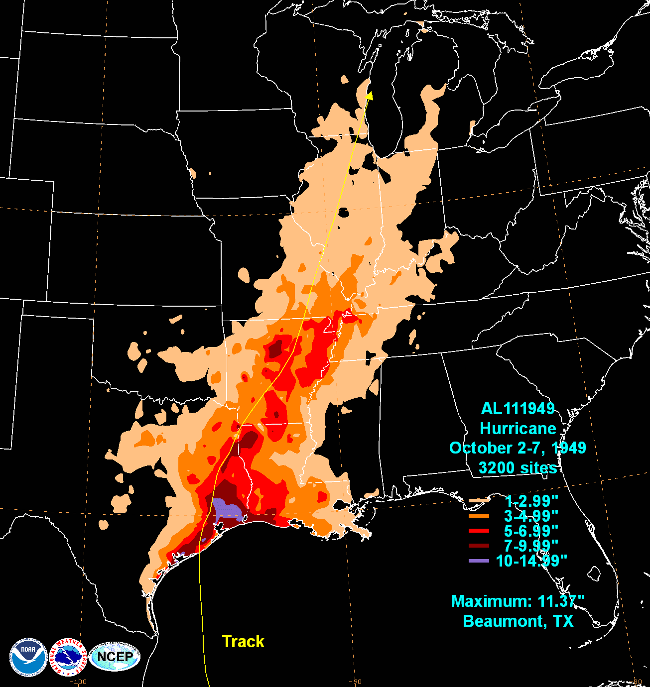
The 1949 Texas hurricane was a tropical cyclone that crossed over from the eastern Pacific to the Atlantic, contributing to extensive flooding in Guatemala and impacting East Texas. Forming in the Pacific Ocean on September 27, the storm meandered across Central America and southern Mexico as a tropical depression. Rainfall from the developing storm helped exacerbate a flooding event over southern Guatemala that may have killed as many as 40,000 people. The storm then crossed into the Gulf of Mexico on October 1 and began to intensify. It ultimately peaked as a high-end Category 2-equivalent hurricane on the modern-day Saffir–Simpson hurricane scale and made landfall near Freeport, Texas, on the morning of October 4. It rapidly weakened after moving inland and dissipated several days later. Damage from the storm was moderate, although the hurricane temporarily cut off the city of Galveston from the mainland. Rice crops suffered extensive damage in Texas ... [...More Info...] [...Related Items...] OR: [Wikipedia] [Google] [Baidu] |
Coordinated Universal Time
Coordinated Universal Time (UTC) is the primary time standard globally used to regulate clocks and time. It establishes a reference for the current time, forming the basis for civil time and time zones. UTC facilitates international communication, navigation, scientific research, and commerce. UTC has been widely embraced by most countries and is the effective successor to Greenwich Mean Time (GMT) in everyday usage and common applications. In specialised domains such as scientific research, navigation, and timekeeping, other standards such as Universal Time, UT1 and International Atomic Time (TAI) are also used alongside UTC. UTC is based on TAI (International Atomic Time, abbreviated from its French name, ''temps atomique international''), which is a weighted average of hundreds of atomic clocks worldwide. UTC is within about one second of mean solar time at 0° longitude, the currently used prime meridian, and is not adjusted for daylight saving time. The coordination of t ... [...More Info...] [...Related Items...] OR: [Wikipedia] [Google] [Baidu] |
East Texas
East Texas is a broadly defined cultural, geographic, and ecological region in the eastern part of the U.S. state of Texas that consists of approximately 38 counties. It is roughly divided into Northeast Texas, Northeast, Southeast Texas, Southeast, and Deep East Texas. Most of the region consists of the Piney Woods ecoregion. East Texas can sometimes be defined only as the Piney Woods. At the fringes, towards Central Texas, the forests expand outward toward sparser trees and eventually into open plains. According to the ''Handbook of Texas'', the East Texas area "may be separated from the rest of Texas roughly by a line extending from the Red River of the South, Red River in north-central Lamar County, Texas, Lamar County southwestward to east-central Limestone County, Texas, Limestone County and then southeastward towards eastern Galveston Bay". Most sources separate the Gulf Coast area into a separate region. The East Texas region includes Kilgore, Texas, Kilgore, Tyler, Te ... [...More Info...] [...Related Items...] OR: [Wikipedia] [Google] [Baidu] |
HURDAT
The Hurricane Databases (HURDAT), managed by the National Hurricane Center (NHC), are two separate databases that contain details on tropical cyclones that have occurred within the Atlantic Ocean and Eastern Pacific Ocean since 1851 and 1949 respectively. The Eastern Pacific database was originally compiled at the NHC during 1976 to help with the initialization with two tropical cyclone forecast models. Initially, tracks for the Central Pacific region and tracks for tropical depressions that did not develop into tropical storms or hurricanes were not included within the database. Over the next few years tracks were archived best track data from the Eastern Pacific Hurricane Center (EPHC) were archived by the NHC on an annual basis. During 1982, the NHC started to include data on Central Pacific tropical storms and hurricanes within the database, before they took over the responsibility for issuing advisories during 1988. The format of the Eastern Pacific database was subsequently ... [...More Info...] [...Related Items...] OR: [Wikipedia] [Google] [Baidu] |
Caribbean Sea
The Caribbean Sea is a sea of the Atlantic Ocean, North Atlantic Ocean in the tropics of the Western Hemisphere, located south of the Gulf of Mexico and southwest of the Sargasso Sea. It is bounded by the Greater Antilles to the north from Cuba to Puerto Rico, the Lesser Antilles to the east from the Virgin Islands to Trinidad and Tobago, South America to the south from the Venezuela, Venezuelan coastline to the Colombia, Colombian coastline, and Central America and the Yucatán Peninsula to the west from Panama to Mexico. The Geopolitics, geopolitical region around the Caribbean Sea, including the numerous islands of the West Indies and adjacent coastal areas in the mainland of the Americas, is known as the Caribbean. The Caribbean Sea is one of the largest seas on Earth and has an area of about . The sea's deepest point is the Cayman Trough, between the Cayman Islands and Jamaica, at below sea level. The Caribbean coastline has many gulfs and bays: the Gulf of Gonâve, the Gul ... [...More Info...] [...Related Items...] OR: [Wikipedia] [Google] [Baidu] |
Tropical Wave
A tropical wave (also called easterly wave, tropical easterly wave, and African easterly wave), in and around the Atlantic Ocean, is a type of atmospheric trough, an elongated area of relatively low air pressure, oriented north to south, which moves from east to west across the tropics, causing areas of cloudiness and thunderstorms. Tropical waves form in the easterly flow along the equatorial side of the subtropical ridge or belt of high air pressure which lies north and south of the Intertropical Convergence Zone (ITCZ). Tropical waves are generally carried westward by the prevailing easterly winds along the tropics and subtropics near the equator. They can lead to the formation of tropical cyclones in the north Atlantic and northeastern Pacific basins. A tropical wave study is aided by Hovmöller diagrams, a graph of meteorological data. West-moving waves can also form from the tail end of frontal zones in the subtropics and tropics, and may be referred to as easterly ... [...More Info...] [...Related Items...] OR: [Wikipedia] [Google] [Baidu] |
Low Pressure Area
In meteorology, a low-pressure area (LPA), low area or low is a region where the atmospheric pressure is lower than that of surrounding locations. It is the opposite of a high-pressure area. Low-pressure areas are commonly associated with inclement weather (such as cloudy, windy, with possible rain or storms), while high-pressure areas are associated with lighter winds and clear skies. Winds circle anti-clockwise around lows in the northern hemisphere, and clockwise in the southern hemisphere, due to opposing Coriolis forces. Low-pressure systems form under areas of wind divergence that occur in the upper levels of the atmosphere (aloft). The formation process of a low-pressure area is known as cyclogenesis. In meteorology, atmospheric divergence aloft occurs in two kinds of places: * The first is in the area on the east side of upper troughs, which form half of a Rossby wave within the Westerlies (a trough with large wavelength that extends through the troposphere). * A sec ... [...More Info...] [...Related Items...] OR: [Wikipedia] [Google] [Baidu] |
Tropical Cyclogenesis
Tropical cyclogenesis is the development and strengthening of a tropical cyclone in the atmosphere. The mechanisms through which tropics, tropical cyclogenesis occur are distinctly different from those through which temperate cyclogenesis occurs. Tropical cyclogenesis involves the development of a warm core, warm-core cyclone, due to significant convection in a favorable atmospheric environment. Tropical cyclogenesis requires six main factors: sufficiently warm sea surface temperatures (at least ), atmospheric instability, high humidity in the lower to middle levels of the troposphere, enough Coriolis force to develop a low-pressure area, low-pressure center, a pre-existing low-level focus or disturbance, and low vertical wind shear. Tropical cyclones tend to develop during the summer, but have been noted in nearly every month in tropical cyclone basins, most basins. Climate cycles such as ENSO and the Madden–Julian oscillation modulate the timing and frequency of tropical c ... [...More Info...] [...Related Items...] OR: [Wikipedia] [Google] [Baidu] |
Galveston, Texas
Galveston ( ) is a Gulf Coast of the United States, coastal resort town, resort city and port off the Southeast Texas coast on Galveston Island and Pelican Island (Texas), Pelican Island in the U.S. state of Texas. The community of , with a population of 53,695 at the 2020 United States census, 2020 census, is the county seat of surrounding Galveston County, Texas, Galveston County and second-largest municipality in the county. It is also within the Greater Houston, Houston–The Woodlands–Sugar Land metropolitan area at its southern end on the northwestern coast of the Gulf of Mexico. Galveston, or Galvez's town, was named after 18th-century Spanish military and political leader Bernardo de Gálvez y Madrid, Count of Gálvez, Bernardo de Gálvez, 1st Count of Gálvez (1746–1786), who was born in Macharaviaya, Málaga, in the Kingdom of Spain. Galveston's first European settlements on the Galveston Island were built around 1816 by Kingdom of France, French pirate Louis-Miche ... [...More Info...] [...Related Items...] OR: [Wikipedia] [Google] [Baidu] |
Freeport, Texas
Freeport is a city in Brazoria County, Texas, United States, located on the Gulf of Mexico, founded in 1912. According to the 2020 United States census, 2020 census, the city population was 10,696, down from 12,049 in 2010, where Hispanic (U.S. Census), Hispanic or Latino (U.S. Census), Latino were 52% of the population. Freeport's economic growth began in 1939 with the construction of Dow Chemical Company facilities, which remain its largest employer and are the largest integrated chemical manufacturing facility in the United States. In 2002, Freeport LNG was founded; an LNG export terminal was developed in the early 2010s after the US shale gas revolution and came online in 2019. In June 2022 a pipeline rupture and explosion closed the terminal until February 2023. History Freeport was founded as a European-American settlement in November 1912 by the Freeport Sulphur Company. The population was 300. However, by 1929, that population had grown to 3,500, and to 4,100 by 19 ... [...More Info...] [...Related Items...] OR: [Wikipedia] [Google] [Baidu] |
Gulf Of Mexico
The Gulf of Mexico () is an oceanic basin and a marginal sea of the Atlantic Ocean, mostly surrounded by the North American continent. It is bounded on the northeast, north, and northwest by the Gulf Coast of the United States; on the southwest and south by the Mexican states of Tamaulipas, Veracruz, Tabasco, Campeche, Yucatán, and Quintana Roo; and on the southeast by Cuba. The coastal areas along the Southern U.S. states of Texas, Louisiana, Mississippi, Alabama, and Florida, which border the Gulf on the north, are occasionally referred to as the "Third Coast" of the United States (in addition to its Atlantic and Pacific coasts), but more often as "the Gulf Coast". The Gulf of Mexico took shape about 300 million years ago (mya) as a result of plate tectonics. The Gulf of Mexico basin is roughly oval and is about wide. Its floor consists of sedimentary rocks and recent sediments. It is connected to part of the Atlantic Ocean through the Straits of Florida between the ... [...More Info...] [...Related Items...] OR: [Wikipedia] [Google] [Baidu] |


