Lærdalsøyri on:
[Wikipedia]
[Google]
[Amazon]
Lærdalsøyri is the

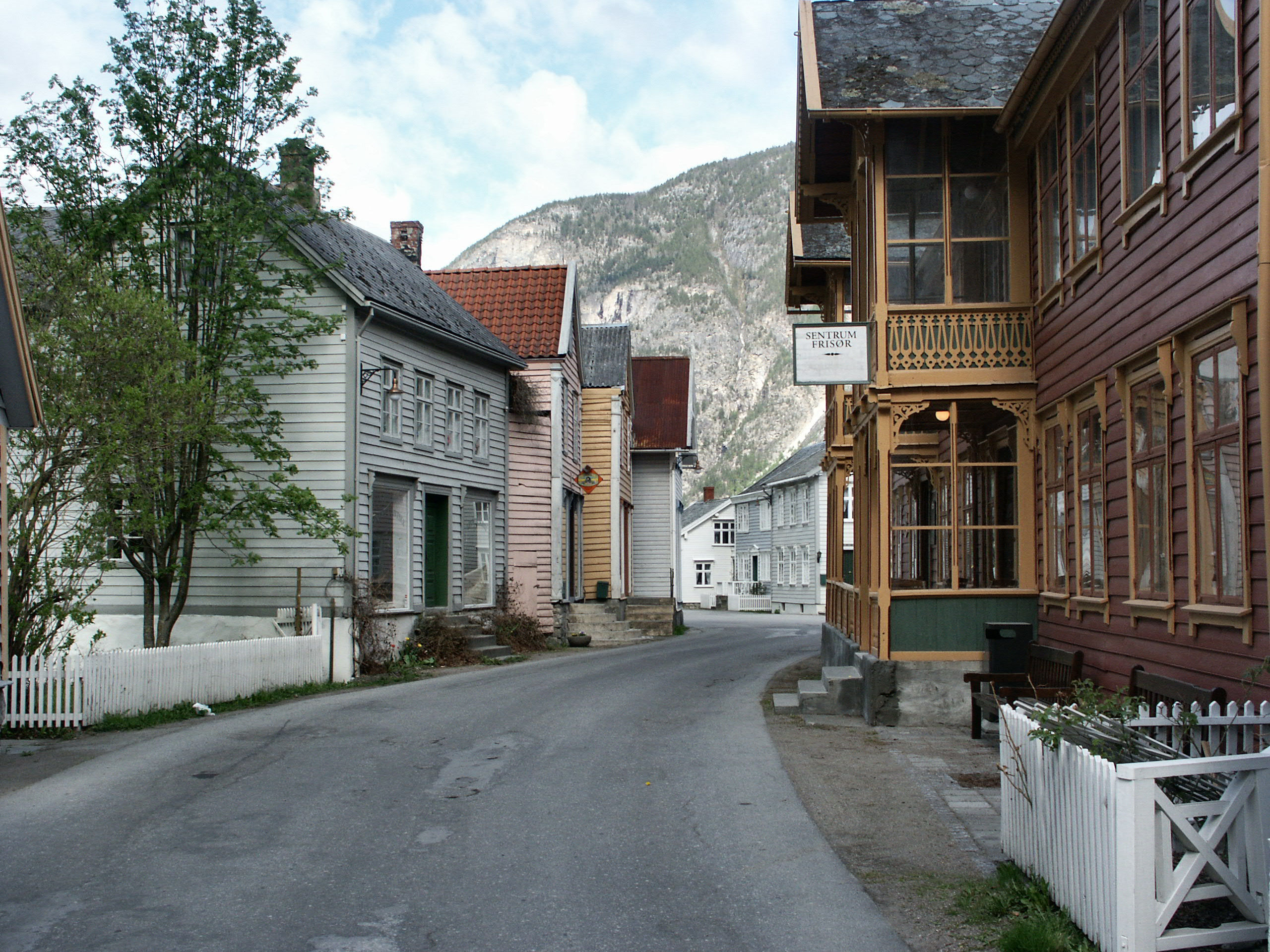
 The village center is listed as a national "heritage village" and tourists come to see the old city center with its 161 wooden houses that date from 1700 to 1800. Old Lærdalsøyri used to be a trading port between east and west in Norway. It is located near the head of
File:Laerdalsoyri03.jpg, Some old houses in Lærdalsøyri
File:Laerdal.JPG, Street in Lærdalsøyri
File:Themistokles von Eckenbrecher Utsikt over Lærdalsøren.jpeg, Painting of Lærdalsøyri in 1901
File:P1000416Norsk Villakssenter.JPG, Norsk Villakssenter
File:Laerdal Oyragata 20.07.2008 1.jpg, View of a building on Oyragata
File:Laerdalsoyri04.jpg, Another historic building
Pictures: Lærdalsoyri
{{DEFAULTSORT:Laerdalsoyri Villages in Vestland Lærdal
administrative centre
An administrative centre is a seat of regional administration or local government, or a county town, or the place where the central administration of a commune, is located.
In countries with French as the administrative language, such as Belgi ...
of Lærdal Municipality
Lærdal is a municipality in Vestland county, Norway. It is located on the south side of the Sognefjorden in the traditional district of Sogn. The administrative center of the municipality is the village of Lærdalsøyri. The old Filefjell Kon ...
in Vestland
Vestland is a Counties of Norway, county in Norway. The county is located in Western Norway, and its administrative centre is Bergen, where the executive and political leadership is based. The County governor (Norway), County Governor is based in ...
county, Norway
Norway, officially the Kingdom of Norway, is a Nordic countries, Nordic country located on the Scandinavian Peninsula in Northern Europe. The remote Arctic island of Jan Mayen and the archipelago of Svalbard also form part of the Kingdom of ...
. The village is located along the Lærdalselvi river where it empties into the Lærdalsfjorden, a branch off of the main Sognefjorden
The Sognefjord or Sognefjorden (, ), nicknamed the King of the Fjords (), is the longest and deepest fjord in Norway. Located in Vestland county in Western Norway, it stretches inland from the ocean to the small village of Skjolden in the muni ...
. The village is located about north of the village of Tønjum
Tønjum is a village in Lærdal Municipality in Vestland county, Norway. The village is located along the river Lærdalselvi, about southeast of the municipal centre of Lærdalsøyri. The eastern end of the Lærdal Tunnel (part of the European ...
at the east end of the Lærdal Tunnel which is part of the European route E16
European route E16 is the designation of a main west–east road through Northern Ireland, Scotland, Norway and Sweden, from Derry to Gävle, via Belfast, Glasgow, Edinburgh, previously by ferry to Bergen, Voss, through the Gudvanga Tunnel and ...
highway. It sits about northwest of the village of Borgund and about across the fjord
In physical geography, a fjord (also spelled fiord in New Zealand English; ) is a long, narrow sea inlet with steep sides or cliffs, created by a glacier. Fjords exist on the coasts of Antarctica, the Arctic, and surrounding landmasses of the n ...
from the village of Kaupanger
Kaupanger is a village situated along the northern shore of the Sognefjorden in the municipality of Sogndal in Vestland county, Norway. It sits along the Norwegian National Road 5, about southeast of the municipal centre of Sogndalsfjøra and a ...
in Sogndal Municipality
Sogndal is a List of municipalities of Norway, municipality in Vestland Counties of Norway, county, Norway. It is located on the northern shore of the Sognefjorden in the Districts of Norway, traditional district of Sogn. The village of Hermansv ...
. Hauge Church
Hauge Church () is a parish church of the Church of Norway in Lærdal Municipality in Vestland county, Norway. It is located in the village of Lærdalsøyri. It is the church for the Hauge parish which is part of the Sogn prosti (deanery) in the D ...
is located in the village, and serves as the main church for the parish.
The village has a population (2019) of 1,135 and a population density
Population density (in agriculture: Standing stock (disambiguation), standing stock or plant density) is a measurement of population per unit land area. It is mostly applied to humans, but sometimes to other living organisms too. It is a key geog ...
of .
Name
The name ''Lærdalsøyri'' is derived from the local river which flows through the village. The first element is the genitive case of the old name of the river ''Lærr'' (now the river is called Lærdalselvi) and the last element is ''dalr'' which means "valley" or "dale." The meaning of the old river name is unknown. The last element ''-øyri'' is the finite form of ''øyr'' which means " sandbank"; it is similar to the wordayre
Ayre ( ; ) is one of the six sheadings of the Isle of Man.
It is located in the north of the island (part of the traditional ''North Side'' division) and consists of the three historic parishes of Andreas, Bride and (Kirk Christ) Lezayre.
T ...
which is used in Scotland
Scotland is a Countries of the United Kingdom, country that is part of the United Kingdom. It contains nearly one-third of the United Kingdom's land area, consisting of the northern part of the island of Great Britain and more than 790 adjac ...
and Orkney
Orkney (), also known as the Orkney Islands, is an archipelago off the north coast of mainland Scotland. The plural name the Orkneys is also sometimes used, but locals now consider it outdated. Part of the Northern Isles along with Shetland, ...
.
History

Sognefjord
The Sognefjord or Sognefjorden (, ), nicknamed the King of the Fjords (), is the list of Norwegian fjords, longest and deepest fjord in Norway. Located in Vestland county in Western Norway, it stretches inland from the ocean to the small village ...
, one of the longest fjords in Norway, which meant sea-going ships could carry goods deep inland before landing them at the village for the over-land journey into eastern Norway.
Historically, several of the County Governors of Nordre Bergenhus lived in Lærdalsøyri while in office including Christian Ulrik Kastrup
Christian Ulrik Kastrup (1784 – 6 September 1850) was a Norwegian jurist, military officer and politician.
A jurist by education, from Stavanger, he worked as a military officer until 1811, when he became chief of customs in Vardø. In 1817 he ...
, Michael Conrad Sophus Emil Aubert, and Johan Collett Falsen.
2014 fire
At 22:56 (10:56 pm) on 18 January 2014, local fire departments were alerted to a fire in a residence on the ''Kyrkjegata'' road. Winds fanned the flames towards the town center, and the fire spread to a nearby forest, threatening the Old Lærdalsøyri heritage area. The town was evacuated at 00:30 (12:30 am), with residents evacuated to a hotel in the nearby municipality ofAurland
Aurland () is a List of municipalities of Norway, municipality in the Counties of Norway, county of Vestland, Norway. It is located on the south side of the Sognefjorden in the Districts of Norway, traditional district of Sogn. The administrativ ...
. By 04:00 in the morning, over thirty houses were in flames.
Notable residents
Media gallery
References
External links
Pictures: Lærdalsoyri
{{DEFAULTSORT:Laerdalsoyri Villages in Vestland Lærdal