Bagrot Valley on:
[Wikipedia]
[Google]
[Amazon]
Bagrot Valley () is a valley in the
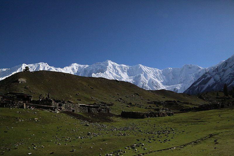
 Bagrot Valley is 38 km from Gilgit and traveling time is two hours plus till Gasunar valley. Geographically it has Rakaposhi ( Raki poshi) and its glacier from where people from Gilgit fetch ice for commercial purposes. This valley was rather inaccessible even for the local population due to the road condition. Now, 2/3rd of the road is metalled and the rest is in a condition that even a small car can travel on it. The valley is blessed with numerous springs, gushing rivers, lofty peaks, glaciers, and the best part is organic fruits and vegetables. The last village is known as Sath Gasunar (also known as Gasunar valley, must-visit point). It has a jumping point for trekkers to traverse Haramosh Valley. From Gasunar valley

 The
The 


 Populated places in Gilgit District
Valleys of Gilgit-Baltistan
{{GilgitBaltistan-geo-stub
Karakoram
The Karakoram () is a mountain range in the Kashmir region spanning the border of Pakistan, China, and India, with the northwestern extremity of the range extending to Afghanistan and Tajikistan. Most of the Karakoram mountain range is withi ...
range in the Gilgit-Baltistan
Gilgit-Baltistan (; ), formerly known as the Northern Areas, is a region administered by Pakistan as an administrative units of Pakistan, administrative territory and consists of the northern portion of the larger Kashmir region, which has b ...
region of northern Pakistan
Pakistan, officially the Islamic Republic of Pakistan, is a country in South Asia. It is the List of countries and dependencies by population, fifth-most populous country, with a population of over 241.5 million, having the Islam by country# ...
. River Bagrot flows through the valley from the north to the southwest, supplying water to the settlements of Jalalabad
Jalalabad (; Help:IPA/Persian, ͡ʒä.lɑː.lɑː.bɑːd̪ is the list of cities in Afghanistan, fifth-largest city of Afghanistan. It has a population of about 200,331, and serves as the capital of Nangarhar Province in the eastern part ...
and Oshikhandass before merging with the Gilgit River
The Gilgit River () is a tributary of the Indus River, flowing through various districts of Pakistan's Gilgit-Baltistan region, including Gupis-Yasin, Ghizer and Gilgit. The Gilgit River originates from Shandur Lake and proceeds to join the I ...
.
Geography
Bagrot valley extends between 2,500 and 4,500 meters above sea level. The principal locality of the valley is Farfu (formerly called Furpui), also known for its landscape and high mountains such asRakaposhi
Rakaposhi (; ) also known as Dumani () is a mountain within the Karakoram range in Gilgit-Baltistan in Pakistan. It is situated in the middle of the Nagar and Bagrote valleys. The mountain is extremely broad, measuring almost from east to west ...
(7,788 m), Diran
Diran () is a mountain in the Karakoram range in Bagrot Valley, Gilgit-Baltistan, Pakistan. This , pyramid-shaped mountain lies to the east of Rakaposhi (7,788m).
Diran was first climbed in 1968 by three Austrian mountaineers: Rainer Goeschl ...
(7,266 m), Bilchar Dobani (6,138 m) , Miar Peak, Godeli and many other peaks that surpass 6,000 meters above sea level. Doboi glaciers, Gargo, Yunay, Boi Pharai, Hurangi, and Raka Poshi surround the valley from where the rivulets forming the Bagrot River are traced. The River Bagrot passes by all the villages of the valley, including Jalalabad
Jalalabad (; Help:IPA/Persian, ͡ʒä.lɑː.lɑː.bɑːd̪ is the list of cities in Afghanistan, fifth-largest city of Afghanistan. It has a population of about 200,331, and serves as the capital of Nangarhar Province in the eastern part ...
and Oshikhandass and merges with the Gilgit River
The Gilgit River () is a tributary of the Indus River, flowing through various districts of Pakistan's Gilgit-Baltistan region, including Gupis-Yasin, Ghizer and Gilgit. The Gilgit River originates from Shandur Lake and proceeds to join the I ...
.
Rakaposhi
Rakaposhi (; ) also known as Dumani () is a mountain within the Karakoram range in Gilgit-Baltistan in Pakistan. It is situated in the middle of the Nagar and Bagrote valleys. The mountain is extremely broad, measuring almost from east to west ...
is visible.
History
Bagrot Valley has long been a cradle of ancient traditions and culture. Rich in history, the valley continues to preserve its cultural heritage and festivals to this day. According to local accounts, the first settler of the valley was Cholok (or Chalok) according to the Peter Snoy. Following him, Tais, Raki, Dodo, and Shoro became the ancestors of many of the present-day inhabitants. Some extinct families of the valley, as mentioned by locals, include Hau Bajiting, Milay Dosay, and Milik Maluway.Geology
The Bagrote valley in Gilgit Baltistan, Pakistan, belonging to the Kohistan island arc and southwestern domain of the Karakorum metamorphic complex, respectively, is a location of regional placer gold mining. The geology of Bagrote valley is mainly composed of the rocks of the Chalt Group. In the study area, the chalt metavolcanic of this group are mainly covering the study area along the eastern and western part of the Bagrote river. However, a small exposure of ultramafic rocks is also exposed in the south-eastern portion of the study area. The terraces of glacial fluvial and fluvial sediments generally cover the Chalt volcanic in the area. The Chalt group consists of a very heterogeneous sequence and is commonly exposed in the surroundings of the upper Gilgit and lower Hunza area. It consists of alternating meta-sediments and volcanic. The association of meta-sediments with tuffs and basaltic to andesitic lavas is well observed in the Bagrote valley. A large number of diorites and granites, which belong to the younger igneous phase, are intruded into the Chalt group. In the upper reaches of the Bulchi and Chirah villages, the Chalt group consists of thinly bedded slates and yellowish pyrite-bearing schists chlorite-epidote hornblende schist with intercalation of this beds of grey to yellowish carbonates and marbles. Towards the north, there is a succession of phyllites, quartzite-phyllites, and sericite schist, which show a continuous transition from basaltic lavas tuff to the chlorite and sericites schist. In Bagrote valley north of Datuche village and near the Gutumi glacier a formation of metamorphic rocks strikes approximately E-W and dips towards the south. It consists of phyllites, sericite-chlorite schists with quartz stringers, and lenses carrying sulfides. These rocks also attained higher metamorphic grades, such as garnet-staurolite schists and gneisses in certain places of Bagrote valley.Demography

 The
The Shina language
Shina ( , ) is a Dardic languages, Dardic language of Indo-Aryan languages, Indo-Aryan language family spoken by the Shina people. In Pakistan, Shina is the major language in Gilgit-Baltistan spoken by an estimated 1,146,000 people living mainl ...
is spoken and understood in all villages of Bagrote. The vernacular language of the Bagrote Valley is distinctive, and so is the local lifestyle, food, and culture. The Bagoreh form an ethnic group.

Tourism and economy
Tourists visit this valley mostly in summer. The valley is about half an hour's drive fromGilgit
Gilgit (; Shina language, Shina: ; ) is a city in Pakistani-administered Gilgit-Baltistan, Gilgit–Baltistan in the disputed Kashmir region.The application of the term "administered" to the various regions of Kashmir and a mention of the Kas ...
city. This is the nearest tourist destination to Gilgit. The side of the Rakaposhi mountain towards Bagrot valley is better for camping due to the lush green forests and less crowd. This valley is known for its fruits and vegetables, also for the glaciers and high peaks. Vegetables, fruits, and other seasonal crops and Ice from the Glaciers during summers is transported from the valley to the capital Gilgit
Gilgit (; Shina language, Shina: ; ) is a city in Pakistani-administered Gilgit-Baltistan, Gilgit–Baltistan in the disputed Kashmir region.The application of the term "administered" to the various regions of Kashmir and a mention of the Kas ...
..
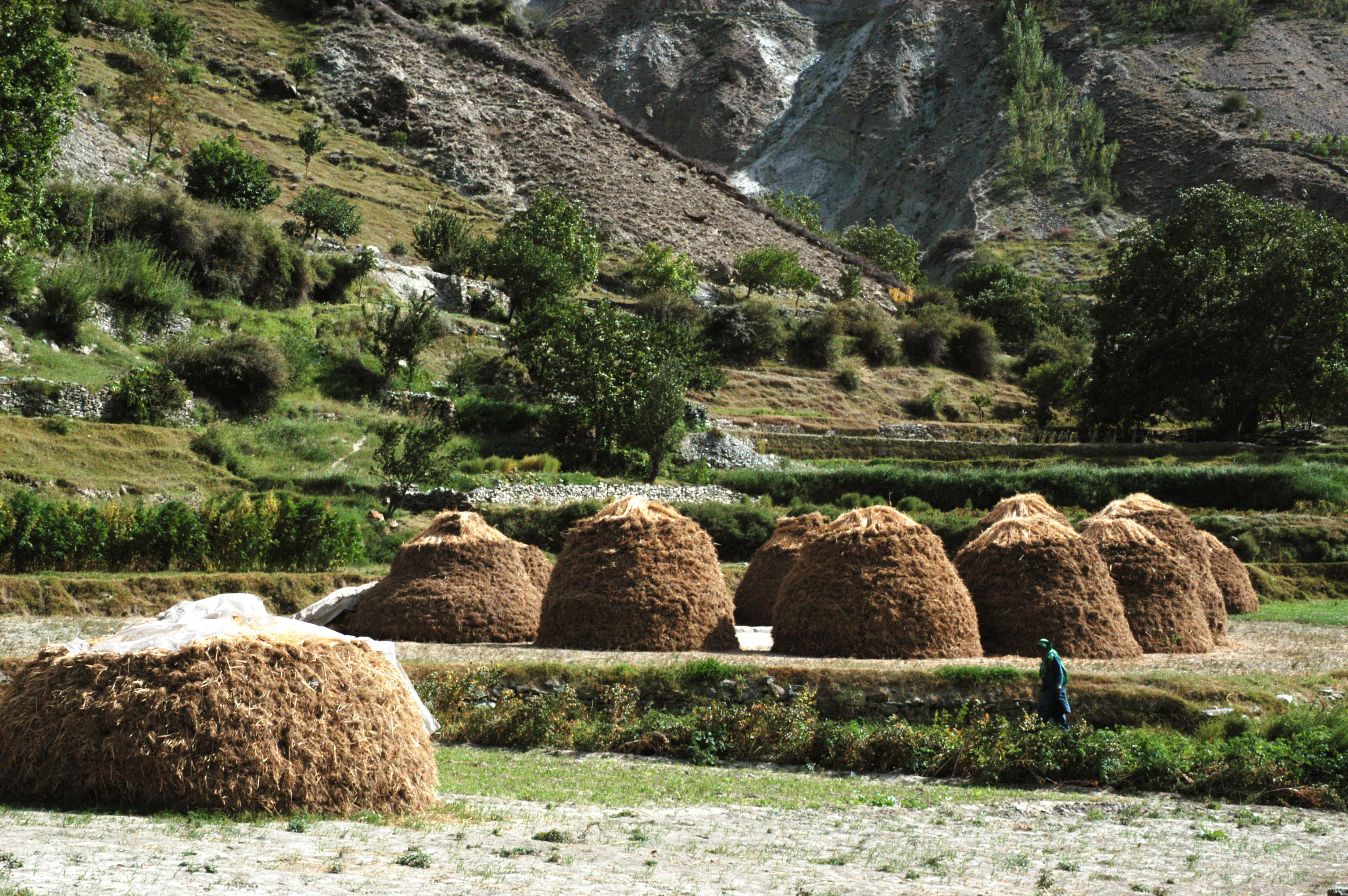
The villages that lie in the valley are interconnected by an unmetalled road. Villages on either side of the valley are linked via cable cars (allowing for easy transport of goods and livestock) and wooden bridges, the river passes underneath which comes from glaciers
A glacier (; or ) is a persistent body of dense ice, a form of rock, that is constantly moving downhill under its own weight. A glacier forms where the accumulation of snow exceeds its ablation over many years, often centuries. It acquires ...
of Karakoram Range. The means of the economy is agriculture. However, with the recent construction of the Karakoram Highway
The Karakoram Highway (, ), also known as the KKH, National Highway 35 (), N-35, and the ChinaPakistan Friendship Highway, is a National Highways of Pakistan, national highway which extends from Hasan Abdal in the Punjab, Pakistan, Punjab p ...
, the area has been exposed to western civilization, with small cinemas, retail outlets for mountain equipment and apparel, and small hotels opening to facilitate visitors.
Locals grow wheat
Wheat is a group of wild and crop domestication, domesticated Poaceae, grasses of the genus ''Triticum'' (). They are Agriculture, cultivated for their cereal grains, which are staple foods around the world. Well-known Taxonomy of wheat, whe ...
, tomato
The tomato (, ), ''Solanum lycopersicum'', is a plant whose fruit is an edible Berry (botany), berry that is eaten as a vegetable. The tomato is a member of the nightshade family that includes tobacco, potato, and chili peppers. It originate ...
es, potato
The potato () is a starchy tuberous vegetable native to the Americas that is consumed as a staple food in many parts of the world. Potatoes are underground stem tubers of the plant ''Solanum tuberosum'', a perennial in the nightshade famil ...
es, apple
An apple is a round, edible fruit produced by an apple tree (''Malus'' spp.). Fruit trees of the orchard or domestic apple (''Malus domestica''), the most widely grown in the genus, are agriculture, cultivated worldwide. The tree originated ...
s, pear
Pears are fruits produced and consumed around the world, growing on a tree and harvested in late summer into mid-autumn. The pear tree and shrub are a species of genus ''Pyrus'' , in the Family (biology), family Rosaceae, bearing the Pome, po ...
s, apricot
An apricot (, ) is a fruit, or the tree that bears the fruit, of several species in the genus ''Prunus''.
Usually an apricot is from the species '' P. armeniaca'', but the fruits of the other species in ''Prunus'' sect. ''Armeniaca'' are also ...
s, etc. in the valley.
Nearby cities and valleys
*Hunza Valley
The Hunza Valley (; ) is a mountainous valley located in the northern region of the Gilgit-Baltistan, Pakistan.
Geography
The valley stretches along the Hunza River and shares borders with Ishkoman Valley, Ishkoman to the northwest, Shigar Val ...
* Nagar Valley
* Gilgit City
*Naltar Valley
The Naltar Valley is a valley situated about from the city of Gilgit in Gilgit-Baltistan, Pakistan. It is a forested area distinguished by its three lakes, Strangi Lake, Blue Lake, and Bodlok Lake, as well as by the mountainous landscape.
...
* Shigar valley
References

 Populated places in Gilgit District
Valleys of Gilgit-Baltistan
{{GilgitBaltistan-geo-stub