|
Whanganui
Whanganui, also spelt Wanganui, is a city in the Manawatū-Whanganui region of New Zealand. The city is located on the west coast of the North Island at the mouth of the Whanganui River, New Zealand's longest navigable waterway. Whanganui is the 19th most-populous urban area in New Zealand and the second-most-populous in Manawatū-Whanganui, with a population of as of . Whanganui is the ancestral home of Te Āti Haunui-a-Pāpārangi and other Whanganui Māori tribes. The New Zealand Company began to settle the area in 1840, establishing its second settlement after Wellington. In the early years, most European settlers came via Wellington. Whanganui greatly expanded in the 1870s, and freezing works, woollen mills, phosphate works and wool stores were established in the town. Today, much of Whanganui's economy relates directly to the fertile and prosperous farming hinterland. Like several New Zealand urban areas, it was officially designated a city until an administrative r ... [...More Info...] [...Related Items...] OR: [Wikipedia] [Google] [Baidu] |
Whanganui River
The Whanganui River is a major river in the North Island of New Zealand. It is the country's third-longest river, and has special status owing to its importance to the region's Māori people. In March 2017 it became the world's second natural resource (after Te Urewera) to be given its own Environmental personhood, legal identity, with the rights, duties and liabilities of a Legal personality, legal person. The Whanganui Treaty settlement brought the longest-running litigation in New Zealand history to an end. Geography With a length of , the Whanganui is the country's third-longest river. Much of the land to either side of the upper reaches is part of the Whanganui National Park, though the river itself is not part of the park. The river rises on the northern slopes of Mount Tongariro, one of the three active volcanoes of the North Island Volcanic Plateau, central plateau, close to Lake Rotoaira. It flows to the north-west before turning south-west at Taumarunui. From he ... [...More Info...] [...Related Items...] OR: [Wikipedia] [Google] [Baidu] |
Whanganui District Council
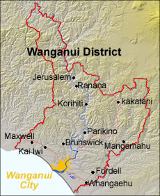
The Whanganui District Council, formerly spelled Wanganui District Council, is the territorial authority for Whanganui District, New Zealand, comprising the city of Whanganui and its surrounding areas. The council is made up of a mayor and 12 councillors, all elected at-large. They are elected using a first-past-the-post system in triennial elections, with the most recent elections having been held in 2022. The current mayor is . History Local government in Whanganui began with the creation of the Wanganui Town Board, within Wellington Province, in 1862. Following the abolishment of the Wellington Province, Wanganui County was founded in 1876. The town board was elevated to a borough council in 1872, and then to a city council in 1924 following amalgamation with the town boards of Wanganui East, Gonville and Castlecliff. Wanganui District Council formed after the 1989 local government reforms with the amalgamation of the Wanganui City Council with the Wanganui C ... [...More Info...] [...Related Items...] OR: [Wikipedia] [Google] [Baidu] |
Putiki Pā, Whanganui (17191005777)
Putiki is a settlement in the Whanganui District and Manawatū-Whanganui region of New Zealand's North Island, located across the Whanganui River from Whanganui city. It includes the intersection of State Highway 3 and State Highway 4. The settlement was established around Pūtiki Pā, a tribal meeting ground of Ngāti Tumango and Ngāti Tupoho. It features Te Paku o Te Rangi meeting house, also known as Aotea meeting house. History 19th century Pūtiki Pā, recorded variously as Putiki Wharanui, Putiki Wharenui, Putiki Warenui, or by its full name Putiki-wharanui-a-Tamatea-pokai-whenua, as a well established pā well before European arrival. The settlement was attacked by Ngāti Toa in a bloody two-month siege in 1828 or 1829. About 400 locals were killed in the encounter. Pūtiki was the main Māori settlement at the Whanganui River mouth when Europeans began settling on the river in the 1840s. Māori from Pūtiki signed a deed of purchase with Edward Gibbon Wakefi ... [...More Info...] [...Related Items...] OR: [Wikipedia] [Google] [Baidu] |
Territorial Authorities Of New Zealand
Territorial authorities ( Māori: ''mana ā-rohe'') are a tier of local government in New Zealand, alongside regional councils. There are 67 territorial authorities: 13 city councils, 53 district councils and the Chatham Islands Council. District councils serve a combination of rural and urban communities, while city councils administer the larger urban areas.City councils serve a population of more than 50,000 in a predominantly urban area. Auckland, Gisborne, Nelson, Tasman and Marlborough each have a unitary authority, which performs the functions of both a territorial authority and a regional council. The Chatham Islands Council is a ''sui generis'' territorial authority that is similar to a unitary authority. Territorial authority districts are not subdivisions of regions, and some of them fall within more than one region. Regional council areas are based on water catchment areas, whereas territorial authorities are based on community of interest and road access. ... [...More Info...] [...Related Items...] OR: [Wikipedia] [Google] [Baidu] |
List Of New Zealand Urban Areas By Population
This article lists urban areas of New Zealand—as defined by Statistics New Zealand—ranked by population. Only the 150 largest urban areas are listed. Urban areas are defined by the Statistical Standard for Geographic Areas 2018 (SSGA18). See also * List of cities in New Zealand * List of towns in New Zealand References {{DEFAULTSORT:New Zealand urban areas Lists of urban areas Lists of populated places in New Zealand, Urban areas Populated places in New Zealand, Urban areas by population ... [...More Info...] [...Related Items...] OR: [Wikipedia] [Google] [Baidu] |
List Of Cities In New Zealand
The word ''city'' took on two meanings in New Zealand after the 1989 New Zealand local government reforms, local government reforms of 1989. Before the reforms, a borough that had a population of 20,000 or more could be proclaimed a city. The boundaries of councils tended to follow the edge of the built-up area, so there was little difference between the urban area and the local government area. In 1989, the structure of local government in New Zealand was significantly reorganised. Almost all the new districts of New Zealand, district councils and city councils were much larger in land area, and they covered both urban land and the surrounding rural land. Many locations that once had a "city council" are now governed by a "district council". Since 2002, an urban area must have at least 50,000 residents to be proclaimed a city. The word ''city'' is used in a general sense to identify the urban areas of New Zealand, independent of local body boundaries. This informal usage is je ... [...More Info...] [...Related Items...] OR: [Wikipedia] [Google] [Baidu] |
Whanganui Māori
Whanganui Māori are the Māori ''iwi'' (tribes) and ''hapū'' (sub-tribes) of the Whanganui River area of New Zealand. They are also known as Ngāti Hau. One group of Whanganui Māori, Whanganui Iwi, includes Te Āti Haunui-a-Pāpārangi and other who signed the Ruruku Whakatupua Treaty of Waitangi settlement in 2015. Awa FM is the radio station of Te Āti Haunui-a-Pāpārangi, Ngāti Hāua and Ngāti Hauiti. It began as Te Reo Irirangi O Whanganui 100FM on 17 June 1991. Between July 1992 and June 1993 it also operated a separate station in Ohakune, known as Te Reo Irirangi Ki Ruapehu or Nga Iwi FM, combining local programmes with shows from 100FM. It is available on in Whanganui, in Ruapehu, and in Taumarunui. Notable people * Kāwana Pitiroi Paipai See also *List of Māori iwi This is a list of iwi (New Zealand Māori tribes). List of iwi This list includes groups recognised as iwi (tribes) in certain contexts. Many are also hapū (sub-tribes) of larger iwi ... [...More Info...] [...Related Items...] OR: [Wikipedia] [Google] [Baidu] |
Wellington
Wellington is the capital city of New Zealand. It is located at the south-western tip of the North Island, between Cook Strait and the Remutaka Range. Wellington is the third-largest city in New Zealand (second largest in the North Island), and is the administrative centre of the Wellington Region. It is the world's southernmost capital of a sovereign state. Wellington features a temperate maritime climate, and is the world's windiest city by average wind speed. Māori oral tradition tells that Kupe discovered and explored the region in about the 10th century. The area was initially settled by Māori iwi such as Rangitāne and Muaūpoko. The disruptions of the Musket Wars led to them being overwhelmed by northern iwi such as Te Āti Awa by the early 19th century. Wellington's current form was originally designed by Captain William Mein Smith, the first Surveyor General for Edward Wakefield's New Zealand Company, in 1840. Smith's plan included a series of inter ... [...More Info...] [...Related Items...] OR: [Wikipedia] [Google] [Baidu] |
North Island
The North Island ( , 'the fish of Māui', historically New Ulster) is one of the two main islands of New Zealand, islands of New Zealand, separated from the larger but less populous South Island by Cook Strait. With an area of , it is the List of islands by area, world's 14th-largest island, constituting 43% of New Zealand's land area. It has a population of which is % of New Zealand's residents, making it the most populous island in Polynesia and the List of islands by population, 28th-most-populous island in the world. Twelve main urban areas (half of them officially cities) are in the North Island. From north to south, they are Whangārei, Auckland, Hamilton, New Zealand, Hamilton, Tauranga, Rotorua, Gisborne, New Zealand, Gisborne, New Plymouth, Napier, New Zealand, Napier, Hastings, New Zealand, Hastings, Whanganui, Palmerston North, and New Zealand's capital city Wellington, which is located at the south-west tip of the island. Naming and usage The island has been known ... [...More Info...] [...Related Items...] OR: [Wikipedia] [Google] [Baidu] |
Regions Of New Zealand
New Zealand is divided into sixteen regions for local government in New Zealand, local government purposes. Eleven are administered by regional councils, and five are administered by Unitary authority#New Zealand, unitary authorities, which are territorial authorities of New Zealand, territorial authorities that also perform the functions of regional councils. Although technically a district but classed as a territory, The Chatham Islands Territory is outside the regions and is administered by the Chatham Islands Council, which is similar to a unitary authority, authorised under its own legislation. Current regions History and statutory basis The regional councils are listed in Part 1 of Schedule 2 of the Local Government Act 2002, along with reference to the ''New Zealand Gazette, Gazette'' notices that established them in 1989. The act requires regional councils to promote sustainable developmentthe social, economic, environmental and cultural well-being of their communitie ... [...More Info...] [...Related Items...] OR: [Wikipedia] [Google] [Baidu] |


