|
Warleggan
Warleggan or Warleggon () is a hamlet and civil parish on the southern edge of Bodmin Moor in Cornwall, England. The parish is roughly oblong in shape and includes the hamlet of Mount, southwest of Warleggan hamlet. The River Warleggan, a tributary of the River Fowey, runs through the parish, forming its western boundary in places. The population was 203 in the 2001 census, and had increased to 208 at the 2011 census. The population in 1801 was 116. A road was built in 1953 linking Warleggan to the A38; until then it had been regarded as one of the most remote areas of Cornwall. Parish church The parish church (dedicated to St Bartholomew) is partly Norman and partly 15th century in date. It formerly had a spire but this fell down in 1818 and was not rebuilt. The church consists of a chancel, nave and south aisle with a granite arcade. From 1931 until his death the Rev. Frederick W. Densham was Rector of Warleggan: he was unworldly and eccentric. The film ''A Congregation of G ... [...More Info...] [...Related Items...] OR: [Wikipedia] [Google] [Baidu] |
Mount, Cornwall
Mount is a village in the parish of Warleggan in east Cornwall Cornwall (; or ) is a Ceremonial counties of England, ceremonial county in South West England. It is also one of the Celtic nations and the homeland of the Cornish people. The county is bordered by the Atlantic Ocean to the north and west, ..., England. It lies south-west of Warleggan village.Ordnance Survey ''One-inch Map of Great Britain; Bodmin and Launceston, sheet 186''. 1961 References Villages in Cornwall {{Cornwall-geo-stub ... [...More Info...] [...Related Items...] OR: [Wikipedia] [Google] [Baidu] |
Bodmin Moor
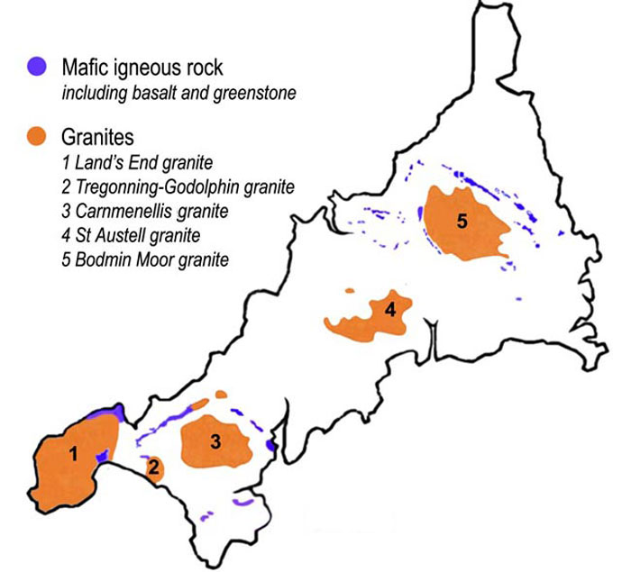
Bodmin Moor () is a granite moorland in north-eastern Cornwall, England, United Kingdom. It is in size, and dates from the Carboniferous period of geology, geological history. It includes Brown Willy, the highest point in Cornwall, and Rough Tor, a slightly lower peak. Many of Cornwall's rivers have their sources here. It has been inhabited since at least the Neolithic era, when early farmers started clearing trees and farming the land. They left their megalithic monuments, hut circles and cairns, and the Bronze Age culture that followed left further cairns, and more stone circles and stone rows. By medieval and modern times, nearly all the forest was gone and livestock rearing predominated. The name Bodmin Moor is relatively recent. An early mention is in the ''Royal Cornwall Gazette'' of 28 November 1812. The upland area was formerly known as Fowey Moor after the River Fowey, which rises within it. Geology Bodmin Moor is one of five granite plutons in Cornwall that make up pa ... [...More Info...] [...Related Items...] OR: [Wikipedia] [Google] [Baidu] |
Civil Parishes In Cornwall
A civil parishes in England, civil parish is a country subdivision, forming the lowest unit of local government in England, local government in England. There are 218 civil parishes in the ceremonial county of Cornwall, which includes the Isles of Scilly. The county is effectively parished in its entirety; only the unpopulated Wolf Rock, Cornwall, Wolf Rock is unparished. At the United Kingdom Census 2001, 2001 census, there were 501,267 people living in the current parishes, accounting for the whole of the county's population. The final unparished areas of mainland Cornwall, around St Austell, were parished on 1 April 2009 to coincide with the 2009 structural changes to local government in England, structural changes to local government in England. Population sizes within the county vary considerably, Falmouth, Cornwall, Falmouth is the most populous with a population of 26,767, recorded in 2011, and St Michael's Mount the least with 29 residents. The county is governed by two ... [...More Info...] [...Related Items...] OR: [Wikipedia] [Google] [Baidu] |
Civil Parishes In England
In England, a civil parish is a type of administrative parish used for local government. It is a territorial designation which is the lowest tier of local government. Civil parishes can trace their origin to the ancient system of parishes, which for centuries were the principal unit of secular and religious administration in most of England and Wales. Civil and religious parishes were formally split into two types in the 19th century and are now entirely separate. Civil parishes in their modern form came into being through the Local Government Act 1894 ( 56 & 57 Vict. c. 73), which established elected parish councils to take on the secular functions of the parish vestry. A civil parish can range in size from a sparsely populated rural area with fewer than a hundred inhabitants, to a large town with a population in excess of 100,000. This scope is similar to that of municipalities in continental Europe, such as the communes of France. However, unlike their continental Europ ... [...More Info...] [...Related Items...] OR: [Wikipedia] [Google] [Baidu] |
Cornwall
Cornwall (; or ) is a Ceremonial counties of England, ceremonial county in South West England. It is also one of the Celtic nations and the homeland of the Cornish people. The county is bordered by the Atlantic Ocean to the north and west, Devon to the east, and the English Channel to the south. The largest urban area is the Redruth and Camborne conurbation. The county is predominantly rural, with an area of and population of 568,210. After the Redruth-Camborne conurbation, the largest settlements are Falmouth, Cornwall, Falmouth, Penzance, Newquay, St Austell, and Truro. For Local government in England, local government purposes most of Cornwall is a Unitary authorities of England, unitary authority area, with the Isles of Scilly governed by a Council of the Isles of Scilly, unique local authority. The Cornish nationalism, Cornish nationalist movement disputes the constitutional status of Cornwall and seeks greater autonomy within the United Kingdom. Cornwall is the weste ... [...More Info...] [...Related Items...] OR: [Wikipedia] [Google] [Baidu] |
River Fowey
The River Fowey ( ; ) is a river in Cornwall, England, United Kingdom. Its source (river), source is at Fowey Well (originally , meaning ''spring of the river Fowey'') about north-west of Brown Willy on Bodmin Moor, not far from one of its tributaries rising at Dozmary Pool and Colliford Lake, passes Lanhydrock House, Restormel Castle and Lostwithiel, then broadens below Milltown, Lanlivery, Milltown before joining the English Channel at Fowey. The estuary is called Uzell (, meaning ''howling place''). It is only navigable by larger craft for the last . From Fowey, there is a passenger ferry to Polruan and a car ferry to Bodinnick. The first road crossing going upstream is in Lostwithiel. The river has seven tributaries, the largest being the Lerryn, River Lerryn. The section of the Fowey Valley between Doublebois and Bodmin Parkway railway station is known as the Glynn Valley (, meaning ''deep wooded valley''). The valley is the route of both the A38 trunk road and the railway l ... [...More Info...] [...Related Items...] OR: [Wikipedia] [Google] [Baidu] |
Methodism
Methodism, also called the Methodist movement, is a Protestant Christianity, Christian Christian tradition, tradition whose origins, doctrine and practice derive from the life and teachings of John Wesley. George Whitefield and John's brother Charles Wesley were also significant early leaders in the movement. They were named ''Methodists'' for "the methodical way in which they carried out their Christian faith". Methodism originated as a Christian revival, revival movement within Anglicanism with roots in the Church of England in the 18th century and became a separate denomination after Wesley's death. The movement spread throughout the British Empire, the United States and beyond because of vigorous Christian mission, missionary work, and today has about 80 million adherents worldwide. Most List of Methodist denominations, Methodist denominations are members of the World Methodist Council. Wesleyan theology, which is upheld by the Methodist denominations, focuses on Sanc ... [...More Info...] [...Related Items...] OR: [Wikipedia] [Google] [Baidu] |
Site Of Special Scientific Interest
A Site of Special Scientific Interest (SSSI) in Great Britain, or an Area of Special Scientific Interest (ASSI) in the Isle of Man and Northern Ireland, is a conservation designation denoting a protected area in the United Kingdom and Isle of Man. SSSI/ASSIs are the basic building block of site-based nature conservation legislation and most other legal nature/geological conservation designations in the United Kingdom are based upon them, including national nature reserve (United Kingdom), national nature reserves, Ramsar Convention, Ramsar sites, Special Protection Areas, and Special Area of Conservation, Special Areas of Conservation. The acronym "SSSI" is often pronounced "triple-S I". Selection and conservation Sites notified for their Biology, biological interest are known as Biological SSSIs (or ASSIs), and those notified for geological or Physical geography, physiographic interest are Geological SSSIs (or ASSIs). Sites may be divided into management units, with some a ... [...More Info...] [...Related Items...] OR: [Wikipedia] [Google] [Baidu] |
Flora And Fauna Of Cornwall
Cornwall is the county that forms the tip of the southwestern peninsula of England; this area has a mild and warm climate regulated by the Gulf Stream. The mild climate allows rich plant cover, such as palm trees in the far south and west of the county and in the Isles of Scilly, due to Subtropics, sub-tropical conditions in the summer. On Cornwall's moors and high ground areas the high elevation makes tree cover impossible because of the wind, so these areas are populated by shrubs and bushes such as gorse and Calluna, heather. Ferns, mosses, liverworts, lichens and fungi can all be found in the county. In the wettest areas of Bodmin Moor, sphagnum or bog moss can be found. Cornwall is home to many rare flower species, especially at the southern end of the Lizard, due to its Geology of Lizard, Cornwall, unique soil and geology. On the Lizard Peninsula, Cornish heath – the floral emblem of Cornwall – mesembryanthemums, butcher's broom, early meadow grass and a wide range of ... [...More Info...] [...Related Items...] OR: [Wikipedia] [Google] [Baidu] |
Natural England
Natural England is a non-departmental public body in the United Kingdom sponsored by the Department for Environment, Food and Rural Affairs. It is responsible for ensuring that England's natural environment, including its land, flora and fauna, freshwater and marine environments, geology and soils, are protected and enhanced. It also has a responsibility to help people enjoy, understand and access the natural environment. Natural England focuses its activities and resources on four strategic outcomes: * a healthy natural environment * enjoyment of the natural environment * sustainable use of the natural environment * a secure environmental future Roles and responsibilities As a non-departmental public body (NDPB), Natural England is independent of government. However, the Secretary of State for Environment, Food & Rural Affairs has the legal power to issue guidance to Natural England on various matters. Its powers include defining ancient woodlands, awarding grants, designatin ... [...More Info...] [...Related Items...] OR: [Wikipedia] [Google] [Baidu] |


