|
River Fowey
The River Fowey ( ; ) is a river in Cornwall, England, United Kingdom. Its source (river), source is at Fowey Well (originally , meaning ''spring of the river Fowey'') about north-west of Brown Willy on Bodmin Moor, not far from one of its tributaries rising at Dozmary Pool and Colliford Lake, passes Lanhydrock House, Restormel Castle and Lostwithiel, then broadens below Milltown, Lanlivery, Milltown before joining the English Channel at Fowey. The estuary is called Uzell (, meaning ''howling place''). It is only navigable by larger craft for the last . From Fowey, there is a passenger ferry to Polruan and a car ferry to Bodinnick. The first road crossing going upstream is in Lostwithiel. The river has seven tributaries, the largest being the Lerryn, River Lerryn. The section of the Fowey Valley between Doublebois and Bodmin Parkway railway station is known as the Glynn Valley (, meaning ''deep wooded valley''). The valley is the route of both the A38 trunk road and the railway l ... [...More Info...] [...Related Items...] OR: [Wikipedia] [Google] [Baidu] |
Bodmin Moor
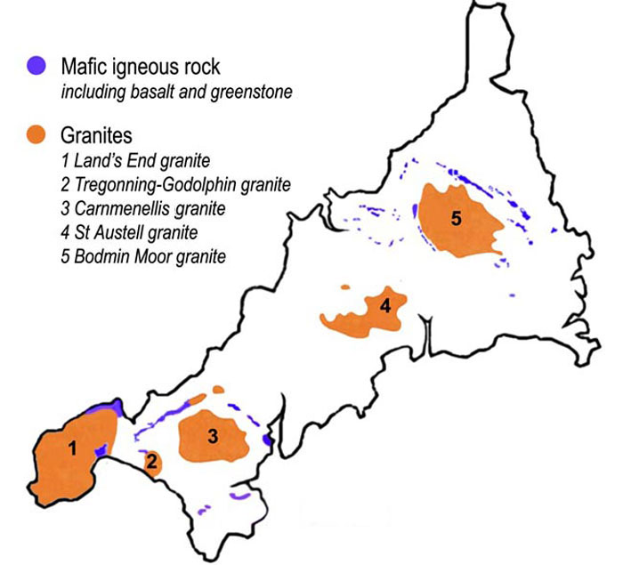
Bodmin Moor () is a granite moorland in north-eastern Cornwall, England, United Kingdom. It is in size, and dates from the Carboniferous period of geology, geological history. It includes Brown Willy, the highest point in Cornwall, and Rough Tor, a slightly lower peak. Many of Cornwall's rivers have their sources here. It has been inhabited since at least the Neolithic era, when early farmers started clearing trees and farming the land. They left their megalithic monuments, hut circles and cairns, and the Bronze Age culture that followed left further cairns, and more stone circles and stone rows. By medieval and modern times, nearly all the forest was gone and livestock rearing predominated. The name Bodmin Moor is relatively recent. An early mention is in the ''Royal Cornwall Gazette'' of 28 November 1812. The upland area was formerly known as Fowey Moor after the River Fowey, which rises within it. Geology Bodmin Moor is one of five granite plutons in Cornwall that make up pa ... [...More Info...] [...Related Items...] OR: [Wikipedia] [Google] [Baidu] |
Ferry
A ferry is a boat or ship that transports passengers, and occasionally vehicles and cargo, across a body of water. A small passenger ferry with multiple stops, like those in Venice, Italy, is sometimes referred to as a water taxi or water bus. Ferries form a part of the public transport systems of many waterside cities and islands, allowing direct transit between points at a capital cost much lower than bridges or tunnels. Ship connections of much larger distances (such as over long distances in water bodies like the Baltic Sea) may also be called ferry services, and many carry vehicles. History The profession of the ferryman is embodied in Greek mythology in Charon, the boatman who transported souls across the River Styx to the Underworld. Speculation that a pair of oxen propelled a ship having a water wheel can be found in 4th century Roman literature "''Anonymus De Rebus Bellicis''". Though impractical, there is no reason why it could not work and such a ferry, mod ... [...More Info...] [...Related Items...] OR: [Wikipedia] [Google] [Baidu] |
Civil Parish
In England, a civil parish is a type of administrative parish used for local government. It is a territorial designation which is the lowest tier of local government. Civil parishes can trace their origin to the ancient system of parishes, which for centuries were the principal unit of secular and religious administration in most of England and Wales. Civil and religious parishes were formally split into two types in the 19th century and are now entirely separate. Civil parishes in their modern form came into being through the Local Government Act 1894 ( 56 & 57 Vict. c. 73), which established elected parish councils to take on the secular functions of the parish vestry. A civil parish can range in size from a sparsely populated rural area with fewer than a hundred inhabitants, to a large town with a population in excess of 100,000. This scope is similar to that of municipalities in continental Europe, such as the communes of France. However, unlike their continental Euro ... [...More Info...] [...Related Items...] OR: [Wikipedia] [Google] [Baidu] |
St Cleer
St Cleer () is a civil parishes in England, civil parish and village in east Cornwall, England, United Kingdom. The village is situated on the southeast flank of Bodmin Moor approximately two miles (3 km) north of Liskeard. The population of the parish in 2001 numbered 3257. This includes Common Moor and had increased to 3,297 at the 2011 census. An electoral ward also exists. The population at the 2011 census is 4,366. Parish church St Cleer parish church, at an elevation of approximately 690 feet (210 metres), is dedicated to Saint Clarus. Its three-stage tower is 97 feet (30 metres) high and contains a ring of six church bells, bells. First built in 800 but rebuilt in the 13th century, the tower suffered damage and was repaired in the 15th century. The church is a Grade I listed building, having been so designated on 21 August 1964. It is of Norman origin, with early fifteenth century additions, further substantial additions in the late fifteenth century and late ninet ... [...More Info...] [...Related Items...] OR: [Wikipedia] [Google] [Baidu] |
King Doniert's Stone
King Doniert's Stone () consists of two pieces of a decorated 9th-century cross, near St Cleer on Bodmin Moor, Cornwall. The inscription is believed to commemorate Dungarth, King of Cornwall, who died around 875. History In the 5th century, Christianity was first brought to Cornwall by monks from Wales and Ireland. The early missionaries are believed to have erected wooden crosses to show places in which they had won victories for Christ. In time these places became sanctified and the wooden crosses were replaced by stone ones. The site The site consists of the remains of two granite cross-shaft fragments dating from the 9th–11th century, and an underground passage and cross-shaped chamber below the crosses, thought to be either the remains of tin workings or a possible oratory. The northern cross, the Doniert Stone, is high with panels of interlace decoration on three sides and inscription ' carved in half uncial or insular script. The inscription translates as "Donier ... [...More Info...] [...Related Items...] OR: [Wikipedia] [Google] [Baidu] |
History Of Cornwall
The history of Cornwall goes back to the Paleolithic, but in this period Cornwall only had sporadic visits by groups of humans. Continuous occupation started around 10,000 years ago after the end of the Younger Dryas, last ice age. When recorded history started in the first century Common Era, BCE, the spoken language was Common Brittonic, and that would develop into Southwestern Brittonic languages, Southwestern Brittonic and then the Cornish language. Cornwall was part of the territory of the tribe of the Dumnonii that included modern-day Devon and parts of Somerset. After a period of Roman Empire, Roman rule, Cornwall reverted to rule by independent Romano-British culture, Romano-British leaders and continued to have a close relationship with Brittany and Wales as well as southern Ireland, which neighboured across the Celtic Sea. After the collapse of Dumnonia, the remaining territory of Cornwall came into conflict with neighbouring Wessex. By the middle of the ninth ce ... [...More Info...] [...Related Items...] OR: [Wikipedia] [Google] [Baidu] |
Donyarth
Donyarth () or Dungarth (died 875) was the last recorded king of Cornwall. He was probably an under-king, paying tribute to the West Saxons. He is thought to be the 'Doniert' recorded on an inscription on King Doniert's Stone, a 9th-century cross shaft which stands in St Cleer parish in Cornwall, although he is not given any title in the inscription. According to the ', he drowned in 875. His death may have been an accident, but it was recorded in Ireland as a punishment for collaboration with the Vikings, who were harrying the West Saxons and briefly occupied Exeter in 876 before being driven out by Alfred the Great following the victory of Odda, Ealdorman of Devon at the Battle of Cynwit in 878. Philip Payton Philip John Payton is a British-Australian historian and emeritus professor of Cornish and Australian studies. Payton is also Vice-President of the British Australian Studies Association at the University of Exeter and formerly director of the ... states that on ... [...More Info...] [...Related Items...] OR: [Wikipedia] [Google] [Baidu] |
Cornwall Railway Viaducts
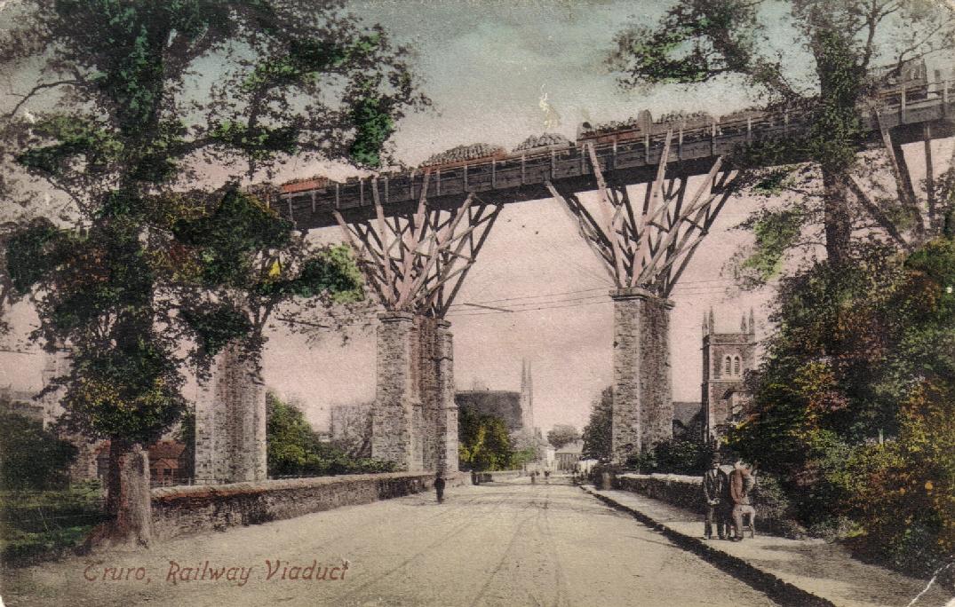
The Cornwall Railway company constructed a railway line between Plymouth and Truro in the United Kingdom, opening in 1859, and extended it to Falmouth in 1863. The topography of Cornwall is such that the route, which is generally east–west, cuts across numerous deep river valleys that generally run north–south. At the time of construction of the line, money was in short supply due to the collapse in confidence following the railway mania, and the company sought ways of reducing expenditure. On the advice of the Victorian railway engineer Isambard Kingdom Brunel, they constructed the river crossings in the form of wooden viaducts, 42 in total, consisting of timber deck spans supported by fans of timber bracing built on masonry piers. This unusual method of construction substantially reduced the first cost of construction compared to an all-masonry structure, but at the cost of more expensive maintenance. Replacement of the timber viaducts by all-masonry structures began in ... [...More Info...] [...Related Items...] OR: [Wikipedia] [Google] [Baidu] |
Cornwall Railway
The Cornwall Railway was a broad gauge railway from Plymouth in Devon to Falmouth, Cornwall, Falmouth in Cornwall, England, built in the second half of the nineteenth century. It was constantly beset with shortage of capital for the construction, and was eventually forced to sell its line to the dominant Great Western Railway. The Cornwall Railway was famous for building the majestic Royal Albert Bridge over the River Tamar and, because of the difficult terrain it traversed, it had a large number of viaducts, built as Cornwall Railway viaducts, timber trestles because of the shortage of money. They proved to be iconic structures, but were a source of heavy maintenance costs, eventually needing to be reconstructed in more durable materials. Its main line was the key route to many of the holiday destinations of Cornwall, and in the first half of the 20th century it carried holidaymakers in summer, as well as vegetables, fish and cut flowers from Cornwall to markets in London an ... [...More Info...] [...Related Items...] OR: [Wikipedia] [Google] [Baidu] |
Bodmin Parkway Railway Station
Bodmin Parkway railway station () is on the Cornish Main Line that serves the nearby town of Bodmin and other parts of mid-Cornwall, England. It is situated south-east of the town of Bodmin in the civil parish of St Winnow, from measured via and . Network Rail’s National Rail Timetable dated May 2023 records the distance from London Paddington to Bodmin Parkway as 252.50 miles. Great Western Railway (train operating company), Great Western Railway manages the station and operates most of the train services, although CrossCountry operates some long-distance services. The Bodmin and Wenford Railway operates a heritage service on the branch to the town on certain days. History Drawings held by Network Rail show that the Liskeard Contract section of Cornwall Railway’s Plymouth to Falmouth scheme, within which Bodmin Road Station was eventually situated, had reached the detailed design stage by June 1854. Original proposals to build a branch to Bodmin, then the most important ... [...More Info...] [...Related Items...] OR: [Wikipedia] [Google] [Baidu] |
Doublebois
Doublebois () (pronounced ), is a village in south Cornwall, England, United Kingdom. It is in the civil parish of Dobwalls approximately three miles (5 km) west of Liskeard.Ordnance Survey: Landranger map sheet 201 ''Plymouth & Launceston'' Doublebois formerly had a railway station on the Cornish Main Line which closed on 5 October 1964. Today the main transport link is the adjacent A38 Plymouth to Bodmin Bodmin () is a town and civil parish in Cornwall, England, United Kingdom. It is situated south-west of Bodmin Moor. The extent of the civil parish corresponds fairly closely to that of the town so is mostly urban in character. It is bordered ... trunk road. References Villages in Cornwall {{Caradon-geo-stub ... [...More Info...] [...Related Items...] OR: [Wikipedia] [Google] [Baidu] |


