|
Vlinder Seamount
Vlinder Guyot (also known as Alba Seamount) is a guyot in the Western Pacific Ocean. It rises to a depth of and has a flat top covering an area of . On top of this flat top lie some volcanic cones, one of which rises to a depth of below sea level. Vlinder Guyot has noticeable rift zones, including an older and lower volcano to the northwest and Oma Vlinder seamount south. Vlinder Guyot formed about 95 million years ago, presumably as a consequence of hotspot (geology), hotspot volcanism. The volcanic island became an atoll with active reefs that eventually drowned in the Albian-Cenomanian, although renewed volcanic activity until the Miocene sometimes sustained shallow water environments. The guyot is currently settled by numerous types of animals and is part of an area leased for mining purposes. Name The seamount is officially known as Alba Guyot, after Francisco Alba, companion of Ferdinand Magellan. Other names are Dalmorgeo, MAGL-3, MA-15, or Vlinder. Geography and geo ... [...More Info...] [...Related Items...] OR: [Wikipedia] [Google] [Baidu] |
Guyot
In marine geology, a guyot (), also called a tablemount, is an isolated underwater volcanic mountain (seamount) with a flat top more than below the surface of the sea. The diameters of these flat summits can exceed . Guyots are most commonly found in the Pacific Ocean, but they have been identified in all the oceans except the Arctic Ocean. They are analogous to tables (such as mesas) on land. History Guyots were first recognized in 1945 by Harry Hammond Hess, who collected data using echo-sounding equipment on a ship he commanded during World War II. His data showed that some undersea mountains had flat tops. Hess called these undersea mountains "guyots", after the Department of Geosciences building at Princeton. Hess postulated they were once volcanic islands that were beheaded by wave action, yet they are now deep under sea level. This idea was used to help bolster the theory of plate tectonics. Formation Guyots show evidence of having once been above the surface, with gr ... [...More Info...] [...Related Items...] OR: [Wikipedia] [Google] [Baidu] |
Caroline Islands
The Caroline Islands (or the Carolines) are a widely scattered archipelago of tiny islands in the western Pacific Ocean, to the north of New Guinea. Politically, they are divided between the Federated States of Micronesia (FSM) in the central and eastern parts of the group, and Palau at the extreme western end. Historically, this area was also called ''Nuevas Filipinas'' or New Philippines, because they were part of the Spanish East Indies and were governed from Manila in the Philippines. The Carolines are scattered across a distance of approximately , from the westernmost island, Tobi (island), Tobi, in Palau, to the easternmost island, Kosrae, a Administrative divisions of the Federated States of Micronesia, state of the FSM. Description The group consists of about 500 small coral islands, east of the Philippines, in the Pacific Ocean. The distance from Yap (one of the larger Caroline islands) to Manila is . Most of the islands are made up of low, flat atoll, coral ato ... [...More Info...] [...Related Items...] OR: [Wikipedia] [Google] [Baidu] |
Piton De La Fournaise
Piton de la Fournaise (; ) is a shield volcano on the eastern side of Réunion island, a French overseas department and region, in the Indian Ocean. It is currently one of the most active volcanoes in the world, along with Kīlauea in the Hawaiian Islands, Stromboli and Etna in Italy and Mount Erebus in Antarctica. A previous eruption began in August 2006 and ended in January 2007. The volcano erupted again in February 2007, on 21 September 2008, on 9 December 2010, which lasted for two days, and on 1 August 2015. The most recent eruption began on 15 September 2022. The volcano is located within Réunion National Park, a World Heritage Site. Residents of Réunion sometimes refer to Piton de la Fournaise simply as ''le Volcan'' ("the Volcano"). It is a major tourist attraction. Geology The uppermost section of the volcano is occupied by the Enclos Fouqué, a caldera wide. High cliffs, known as ''remparts'' in French, form the caldera's rim. The caldera is breached to the s ... [...More Info...] [...Related Items...] OR: [Wikipedia] [Google] [Baidu] |
Sector Collapse
A sector collapse or lateral collapse is the structural failure and subsequent collapse of a minimum volume of of a volcano. Unlike smaller flank collapses, a sector collapse can involve the central volcanic pipe and historically this term had been restricted by some writers to such events in arc stratovolcanoes, but is now used for large events in any volcano. Sector collapses are one of the most hazardous volcanic events, often resulting in lateral blasts, landslides, and changes in volcanic eruptive behavior. Sector collapse can be caused by earthquakes, volcanic eruptions, gradual volcanic deformation, and other processes. Sector collapse events can occur on volcanoes at convergent and divergent plate boundaries. Sector collapses are generally very sudden; however, some attempts have been made to predict collapse events. Causes Internal Sector collapse can result from internal volcanic processes. Volcanic eruption can damage originally stable magma chambers, caus ... [...More Info...] [...Related Items...] OR: [Wikipedia] [Google] [Baidu] |
Rejuvenated Stage Volcanism
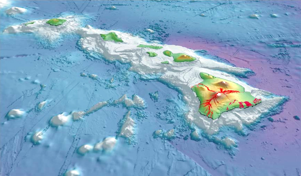
The evolution of Hawaiian volcanoes occurs in several stages of growth and decline. The fifteen volcanoes that make up the eight principal islands of Hawaii are the youngest in a chain of more than 129 volcanoes that stretch across the North Pacific Ocean, called the Hawaiian–Emperor seamount chain. Hawaii's volcanoes rise an average of to reach sea level from their base. The largest, Mauna Loa, is high. As shield volcanoes, they are built by accumulated lava flows, growing a few meters or feet at a time to form a broad and gently sloping shape. Hawaiian islands undergo a systematic pattern of submarine and subaerial growth that is followed by erosion. An island's stage of development reflects its distance from the Hawaii hotspot. Background The Hawaiian–Emperor seamount chain is remarkable for its length and its number of volcanoes. The chain is split into two subsections across a break, separating the older Emperor Seamount Chain from the younger Hawaiian Ridge; the V- ... [...More Info...] [...Related Items...] OR: [Wikipedia] [Google] [Baidu] |
Pelagic Sediment
Pelagic sediment or pelagite is a fine-grained sediment that accumulates as the result of the settling of particles to the floor of the open ocean, far from land. These particles consist primarily of either the microscopic, calcareous or siliceous shells of phytoplankton or zooplankton; clay-size siliciclastic sediment; or some mixture of these, along with detritus (marine snow) included. Trace amounts of meteoric dust and variable amounts of volcanic ash also occur within pelagic sediments. Based upon the composition of the ooze, there are three main types of pelagic sediments: siliceous oozes, Calcareous#Marine sediments, calcareous oozes, and Pelagic red clay, red clays.Rothwell, R.G., (2005) ''Deep Ocean Pelagic Oozes'', Vol. 5. of Selley, Richard C., L. Robin McCocks, and Ian R. Plimer, Encyclopedia of Geology, Oxford: Elsevier Limited. HüNeke, H., and T. Mulder (2011) ''Deep-Sea Sediments''. Developments in Sedimentology, vol. 63. Elsiever, New York. 849 pp. The composi ... [...More Info...] [...Related Items...] OR: [Wikipedia] [Google] [Baidu] |
Ogasawara Fracture Zone
Ogasawara (written: 小笠原) is a Japanese surname. It may also refer to: Locations * Ogasawara Islands, also known as the Bonin Islands, an archipelago of over 30 islands about 1000 km south of Tokyo, Japan * Ogasawara National Park, an island national park located on that archipelago * Ogasawara Subprefecture, a subprefecture of Tokyo, Japan * Ogasawara, Tokyo, a village in Ogasawara Subprefecture, Tokyo, Japan, that governs the Bonin Islands People with the surname *, a Japanese voice actress *, a Japanese anime director from Chiba, Japan *, a Japanese Olympic Curler *, a Japanese baseball player *, Japanese speed skater *, a Japanese football (soccer) player *, Japanese baseball player *, Japanese rower Fictional *, a fictional main character in the ''Maria-sama ga Miteru'' media series *, a character from ''Hibike! Euphonium'' Historical *, a Japanese samurai clan *, a Japanese retainer of the Minamoto clan during the Heian period *, the 6th and final daimyō of Karat ... [...More Info...] [...Related Items...] OR: [Wikipedia] [Google] [Baidu] |
Lineament
''See also Line (geometry)'' A lineament is a linear feature in a landscape which is an expression of an underlying geological structure such as a fault. Typically a lineament will appear as a fault-aligned valley, a series of fault or fold-aligned hills, a straight coastline or indeed a combination of these features. Fracture zones, shear zones and igneous intrusions such as dykes can also be expressed as geomorphic lineaments. Lineaments are often apparent in geological or topographic maps and can appear obvious on aerial or satellite photographs. There are for example, several instances within Great Britain. In Scotland the Great Glen Fault and Highland Boundary Fault give rise to lineaments as does the Malvern Line in western England and the Neath Disturbance in South Wales. The term 'megalineament' has been used to describe such features on a continental scale. The trace of the San Andreas Fault might be considered an example.Whitten & Brooks, The Penguin Dictionary of G ... [...More Info...] [...Related Items...] OR: [Wikipedia] [Google] [Baidu] |
Samoa Hotspot
The Samoa hotspot is a volcanic hotspot located in the south Pacific Ocean. The hotspot model describes a hot upwelling plume of magma through the Earth's crust as an explanation of how volcanic islands are formed. The hotspot idea came from J. Tuzo Wilson in 1963 based on the Hawaiian Islands volcanic chain. In theory, the Samoa hotspot is based on the Pacific Tectonic Plate travelling over a fixed hotspot located deep underneath the Samoan Islands. The Samoa hotspot includes the Samoan Islands (American Samoa and Samoa), and extends to the islands of Uvea or Wallis Island (Wallis and Futuna) and Niulakita (Tuvalu), as well as the submerged Pasco banks and Alexa Bank. As the Pacific Plate moves slowly over the hotspot, thermal activity builds up and is released in magma plume spewing through the Earth's crust, forming each island in a chain. The Samoa islands generally lie in a straight line, east to west, in the same direction of the tectonic plate 'drifting' over the ... [...More Info...] [...Related Items...] OR: [Wikipedia] [Google] [Baidu] |
Rarotonga Hotspot
The Rarotonga hotspot is a volcanic hotspot in the southern Pacific Ocean. The hotspot is claimed to be responsible for the formation of Rarotonga and some volcanics of Aitutaki but an alternative explanation for these islands most recent volcanics has not been ruled out. Recently alternatives to hotspot activity have been offered for several other intra-plate volcanoes that may have been associated with the Rarotonga hotspot hypothesis. In addition to these volcanoes in the Cook Islands, the composition of volcanic rocks in Samoa and in the Lau Basin may have been influenced by the Rarotonga hotspot, and some atolls and seamounts in the Marshall Islands may have formed on the hotspot as well. Geology Oceanic plateaus and linear volcanic chains dot the floor of the Pacific Ocean. Their formation has been explained with mantle plumes which rise from the core-mantle boundary and spread out when they rise, forming a large "head" that causes intense volcanic activity once it hi ... [...More Info...] [...Related Items...] OR: [Wikipedia] [Google] [Baidu] |
Ita Mai Tai
Ita Mai Tai is a Cretaceous-early Cenozoic seamount northwest of the Marshall Islands and north of Micronesia. One among a number of seamounts in the Pacific Ocean, it is part of the Magellan Seamounts which may have a hotspot origin although Ita Mai Tai itself may not have formed on a hotspot. The seamount is formed by volcanic rocks which form two adjacent volcanic centres that erupted between the Aptian-Albian and possibly as late as the Pliocene. Reef systems developed on the seamount after its formation and led to the deposition of limestones. Especially during the Oligocene the seamount subsided and lies now at depth below sea level. Ferromanganese crusts as well as pelagic oozes were deposited on the submerged rocks. Name and research history The name ''Ita Mai Tai'' comes from the Tahitian language and means "no damn good". The name was coined by Bruce C. Heezen and is probably a reference to unsuccessful attempts to obtain drill cores during the early research hist ... [...More Info...] [...Related Items...] OR: [Wikipedia] [Google] [Baidu] |


