|
Caroline Islands
The Caroline Islands (or the Carolines) are a widely scattered archipelago of tiny islands in the western Pacific Ocean, to the north of New Guinea. Politically, they are divided between the Federated States of Micronesia (FSM) in the central and eastern parts of the group, and Palau at the extreme western end. Historically, this area was also called ''Nuevas Filipinas'' or New Philippines, because they were part of the Spanish East Indies and were governed from Manila in the Philippines. The Carolines are scattered across a distance of approximately , from the westernmost island, Tobi (island), Tobi, in Palau, to the easternmost island, Kosrae, a Administrative divisions of the Federated States of Micronesia, state of the FSM. Description The group consists of about 500 small coral islands, east of the Philippines, in the Pacific Ocean. The distance from Yap (one of the larger Caroline islands) to Manila is . Most of the islands are made up of low, flat atoll, coral ato ... [...More Info...] [...Related Items...] OR: [Wikipedia] [Google] [Baidu] |
Mau Piailug
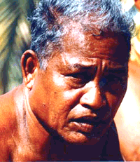
Pius "Mau" Piailug (pronounced ; 1932 – 12 July 2010) was a Micronesian navigator from the Carolinian island of Satawal, best known as a teacher of traditional, non-instrument wayfinding methods for open-ocean voyaging. Mau's Carolinian navigation system, which relies on navigational clues using the Sun and stars, winds and clouds, seas and swells, and birds and fish, was acquired through rote learning passed down through teachings in the oral tradition. He earned the title of master navigator (''palu'') by the age of eighteen, around the time the first American missionaries arrived in Satawal. As he neared middle age, Mau grew concerned that the practice of navigation in Satawal would disappear as his people became acculturated to Western values. In the hope that the navigational tradition would be preserved for future generations, Mau shared his knowledge with the Polynesian Voyaging Society (PVS). With Mau's help, PVS used experimental archaeology to recreate and ... [...More Info...] [...Related Items...] OR: [Wikipedia] [Google] [Baidu] |
Nett
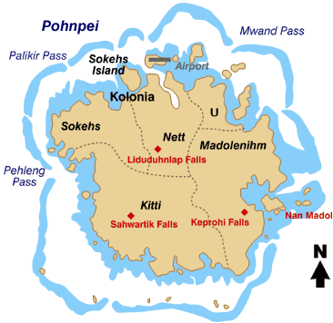
Nett also written as Net, is one of the administrative divisions of Pohnpei State, Federated States of Micronesia. Description Nett is one of the six municipalities located in the main island of Pohnpei. It corresponds to the north-central sector of the island. The population was 6,639 as of 2010. Nett municipality formerly included Kolonia, now a separate administrative division. Nett has been historically subdivided into 23 sections, districts, or villages (''kousapw''): Parempei, Lenger, Leprohi, Sekeren, Weipowe, Diadi, Tomwara, Dolokei, Lewetik, Takaieu, Paliais, Seinwar, Meitik, Paremkep, Nansokasok (Nan Sokasok), Eirike (Eirke), Nanipil, Kahmar, Doaroapop, Pohndien, Dolakapw, Mesenieng, and Lehdau. This includes ''Mesenieng'', which is the traditional name of the now separate municipality Kolonia, which is still claimed by Nett municipality as one of its ''kousapw''. The ''kousapw'' are or were further subdivided into peliensapw (farmsteads). Education Pohnpei Stat ... [...More Info...] [...Related Items...] OR: [Wikipedia] [Google] [Baidu] |
Ngulu Atoll
Ngulu Atoll is a coral atoll of three islands in the Caroline Islands in the Pacific Ocean, and forms a legislative district in Yap State in the Federated States of Micronesia. Ngulu extends for by with 18 reef segments enclosing a deep central lagoon of . The eastern portion of the reef is deeply submerged. Its total land area of the nine islets is only . Nugulu is located approximately south-southwest of Yap and is the westernmost atoll in the Federated States of Micronesia. The population of Ngulu was 26 in 2000. History First recorded sighting of Ngulu Atoll was by the Spanish navigator Alonso de Arellano on 23 January 1565 on board of the patache ''San Lucas''.Sharp, Andrew ''The discovery of the Pacific Islands'' Oxford, 1960, p.36. In 1802 it was explored by Spanish naval officer Don Juan Lafita. As with all of the Caroline Islands, sovereignty was sold by Spain to the Empire of Germany in 1899. The island came under the control of the Empire of Japan after W ... [...More Info...] [...Related Items...] OR: [Wikipedia] [Google] [Baidu] |
Kanifay
Kanifay () is a village and municipality in the state of Yap, Federated States of Micronesia The Federated States of Micronesia (, abbreviated FSM), or simply Micronesia, is an island country in Micronesia, a region of Oceania. The federation encompasses the majority of the Caroline Islands (excluding Palau) and consists of four Admin .... ReferencesStatoids.com retrieved December 8, 2010 Municipalities of Yap {{Micronesia-geo-stub ... [...More Info...] [...Related Items...] OR: [Wikipedia] [Google] [Baidu] |
Maap
Maap () is an island and village and municipality in the state of Yap, Federated States of Micronesia. It lies on the north east of the archipelago An archipelago ( ), sometimes called an island group or island chain, is a chain, cluster, or collection of islands. An archipelago may be in an ocean, a sea, or a smaller body of water. Example archipelagos include the Aegean Islands (the o ... of Yap. References Statoids.com retrieved February 13, 2015 Municipalities of Yap {{Micronesia-geo-stub ... [...More Info...] [...Related Items...] OR: [Wikipedia] [Google] [Baidu] |
Rumung
Rumung is a village and municipality in the state of Yap, Federated States of Micronesia The Federated States of Micronesia (, abbreviated FSM), or simply Micronesia, is an island country in Micronesia, a region of Oceania. The federation encompasses the majority of the Caroline Islands (excluding Palau) and consists of four Admin .... It is also the northernmost main island. ReferencesStatoids.com retrieved December 8, 2010 Municipalities of Yap {{Micronesia-geo-stub ... [...More Info...] [...Related Items...] OR: [Wikipedia] [Google] [Baidu] |
Weno
Weno, formerly Moen, is an island municipality of Chuuk State of the Federated States of Micronesia (FSM). It is the largest town in the FSM and the capital of Chuuk. It has an estimated area of 20 square kilometers. Population The population was 13,856 at the census taken in 2010. Geography It is located in the Chuuk Lagoon. Its villages are on the coast (Sapuk, Penia, Peniesene, Tunnuk, Mechitiw, Iras, Nantaku, Nepukos, Mwan, Neiwe, and Wichap, Epinup) and serve as the center of commerce. Weno is the state capital and the second-most populous island of the FSM (if the complex of Tol/Wonei, Polle and Patta is counted as one island), with a population of 13,856 at the 2010 census. The highest point is Mount Teroken, elevation 364 m (1,214 ft). Transportation Weno has the only airport in the state, Chuuk International Airport. The road system is not well established in some parts of the island. No public transportation exists, but visitors can use a small taxi ... [...More Info...] [...Related Items...] OR: [Wikipedia] [Google] [Baidu] |
Nomoi Islands
The Nomoi Islands, also known as the Mortlock Islands, are a group of three atolls in the state of Chuuk, Federated States of Micronesia. They are located approximately southeast of Chuuk Lagoon. Islands The Mortlock Islands are made up of the islands Ettal, Namoluk, Ta, Nama, Oneop, Losap, Moch, Picemwar, Satawan, Lukunor (Likinioch), and Kuttu (KuKuttu). Losap, Nama, and Namoluk are clustered to the northwest of the other islands, and are also called the Upper Mortlock Islands or Eastern Islands. Satawan, the southern atoll, is the largest. Both Etal, to the north, and Lukunor to the northeast are significantly smaller. They are located between of each other. History The Namoi Islands have thought to have been initially settled eight to nine hundred years ago by natives moving eastward from the Chuuk Lagoon.Odango, Emerson. 2015Afféú Fangani ‘Join Together’: A Morphophonemic Analysis Of Possessive Suffix Paradigms And A Discourse-Based Ethnography Of Th ... [...More Info...] [...Related Items...] OR: [Wikipedia] [Google] [Baidu] |
Hall Islands
The Hall Islands are a group of two large atolls in the northern part of the state of Chuuk, Federated States of Micronesia. In the broader sense, a third and smaller atoll is included. Nomwin, the western atoll, and Murilo, the eastern one, are located about 9 km apart, being the emergent parts of a twin-lobed seamount. Murilo and Nomwin each harbor a population of more than 1,000 peoplThey lie roughly 100 km to the north of Chuuk Lagoon Chuuk Lagoon, previously Truk Atoll, is an atoll in the central Pacific Ocean. It lies about 1,800 kilometres (970 nautical miles) northeast of New Guinea and is part of Chuuk State within the Federated States of Micronesia (FSM). A protective .... Uninhabited East Fayu, lying 30+ km to the west of Nomwin, is sometimes included in the HallThe three atolls together account for a dry surface of about 3.5 km2 over more than 50 islets or motu (geography), motus. References Islands of Chuuk State Atolls of the Federated St ... [...More Info...] [...Related Items...] OR: [Wikipedia] [Google] [Baidu] |
Namonuito Atoll
Namonuito Atoll, also called Namonweito, Weito, or Magur Islands, is the largest atoll of the Federated States of Micronesia and of the Caroline Islands with a total area of , unless one considers the still larger Chuuk (Truk) Lagoon as a type of atoll in an early stage of development. In Micronesia, only Kwajalein Atoll of the Marshall Islands is still larger. Namonuito Atoll lies in the northwestern region (''Oksoritod'') of Chuuk State, the largest federal state of the Federated States of Micronesia, about northwest of Chuuk Lagoon (measured from Pisaras Islet to the northern and western parts of the fringing reef of Chuuk Lagoon. It is roughly triangular in shape, with the base running along its southern side. The southwest corner of the triangle is marked by Onoun islet, the main island (largest and most populated), also called Ulul. The other islets lie mostly on the northeast side, from Piherarh (Pisaras) in the southeast corner to Makur (Magur) islet in the north ... [...More Info...] [...Related Items...] OR: [Wikipedia] [Google] [Baidu] |
Faichuk
Faichuk (also Faichuuk, Tol, or the Western Islands) is a group of four islands separated from one another by narrow canals in the western part of Truk Lagoon, Chuuk, Micronesia Micronesia (, ) is a subregion of Oceania, consisting of approximately 2,000 small islands in the Northwestern Pacific Ocean. It has a close shared cultural history with three other island regions: Maritime Southeast Asia to the west, Poly .... The tightly knit islands are considered as one for statistical and administrative purposes. The islands are Paata (Pata), Polle, Wonei (Onei), and Tol (these four, because of their proximity, are sometimes collectively subsumed under the island name Tol), Eot, Fanapanges, Romanum and Udot. Their aggregate area is 41.90 or 49.63 km2, according to different sources. The population is 16,000. The islands are mostly hilly and peak at 443 meters above sea level (Mount Winipot on Tol Island). Mount Winipot is also the highest point of the Chuuk Stat ... [...More Info...] [...Related Items...] OR: [Wikipedia] [Google] [Baidu] |


