|
Vaalserberg
The Vaalserberg (; ) is a hill with a height of above Amsterdam Ordnance Datum, NAP and is the highest point in the Netherlands#Geography, European part of the Netherlands. The Vaalserberg is located in the province of Limburg (Netherlands), Limburg, at the south-easternmost edge of the country, near the town of Vaals (after which it is named). The Vaalserberg was the highest point anywhere in the Netherlands until the Caribbean island of Saba (island), Saba, with its Mount Scenery, volcano, was incorporated into the country as a "special municipality" in 2010. Three-country point The Vaalserberg is also the location of the tripoint between Germany, Belgium and the Netherlands and so its summit is called the ''Drielandenpunt'' ("three country point") in Dutch, ''Dreiländereck'' ("three country corner") in German and ''Trois Frontières'' ("three borders") or ''Trois Bornes'' ("three border stones") in French. On the Belgian side, the tripoint borders the region of Wallon ... [...More Info...] [...Related Items...] OR: [Wikipedia] [Google] [Baidu] |
Aachen
Aachen is the List of cities in North Rhine-Westphalia by population, 13th-largest city in North Rhine-Westphalia and the List of cities in Germany by population, 27th-largest city of Germany, with around 261,000 inhabitants. Aachen is located at the northern foothills of the High Fens and the Eifel Mountains. It sits on the Wurm (Rur), Wurm River, a tributary of the Rur (river), Rur, and together with Mönchengladbach, it is the only larger German city in the drainage basin of the Meuse. It is the westernmost larger city in Germany, lying approximately west of Cologne and Bonn, directly bordering Belgium in the southwest, and the Netherlands in the northwest. The city lies in the Meuse–Rhine Euroregion and is the seat of the Aachen (district), district of Aachen ''(Städteregion Aachen)''. The once Celts, Celtic settlement was equipped with several in the course of colonization by Roman people, Roman pioneers settling at the warm Aachen thermal springs around the 1st cen ... [...More Info...] [...Related Items...] OR: [Wikipedia] [Google] [Baidu] |
Neutral Moresnet
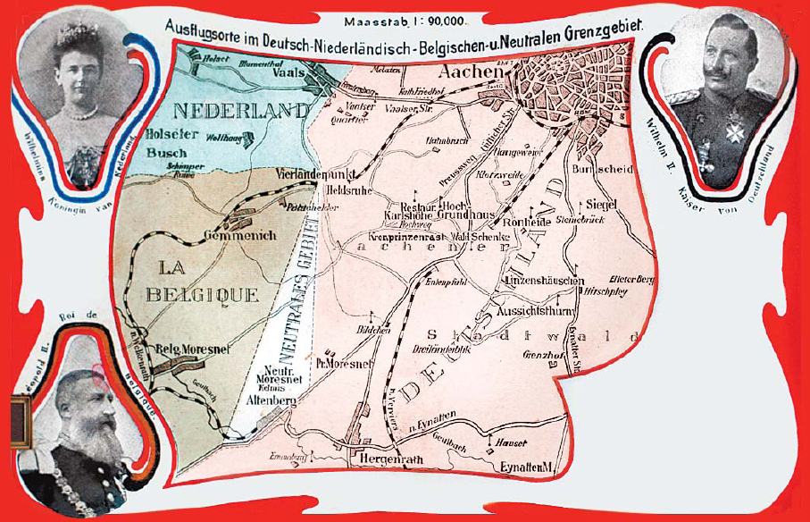
Neutral Moresnet (, , , ) was a small Belgian–Prussian condominium in western Europe that existed from 1816 to 1921 and was administered jointly by the United Kingdom of the Netherlands (Belgium after its independence in 1830) and the Kingdom of Prussia. It was wide and long, with an area of . After 1830, the territory's northernmost border point at Vaalserberg connected it to a quadripoint shared additionally with the Dutch Province of Limburg, the Prussian Rhine Province, and the Belgian Liège Province. That border point's position is currently represented by the Three-Country Point, the meeting place of the borders of Belgium, Germany, and the Netherlands. During the First World War, Neutral Moresnet was annexed by Germany. The armistice between France and Germany in November 1918 forced Germany to withdraw from Belgium and Neutral Moresnet. A year later, the Treaty of Versailles awarded Neutral Moresnet to Belgium, as from 10 January 1921, when it become the munic ... [...More Info...] [...Related Items...] OR: [Wikipedia] [Google] [Baidu] |
Vaals
Vaals (; ) is a town in the extreme southeastern part of the Dutch province of Limburg, itself in the southeast of the Netherlands. The municipality covers an area of .It is situated in the western foothills of the Ardennes–Eifelrange and lies some east of Maastricht and west of the German city of Aachen. Vaals directly adjoins both Belgium and Germany. As such three national borders meet at a point known as the Drielandenpunt and very near the highest point in the Netherlands, the Vaalserberg. The Vaalserberg was previously known as " Hubertusberg", so named for the eighth century St.Hubertus. History Vaals' name is derived from Latin, one of very few such geographical names in the Netherlands. The south of the Dutch province of Limburg, which included 'Vallis', was previously part of the Roman Empire, the local region having been centred on the present day German city of Cologne (Colonia Claudia Ara Agrippinensium). Vaals is first mentioned in historical docu ... [...More Info...] [...Related Items...] OR: [Wikipedia] [Google] [Baidu] |
Moresnet
Neutral Moresnet (, , , ) was a small Belgium, Belgian–Prussian condominium (international law), condominium in western Europe that existed from 1816 to 1921 and was administered jointly by the United Kingdom of the Netherlands (Belgium after its independence in 1830) and the Kingdom of Prussia. It was wide and long, with an area of . After 1830, the territory's northernmost border point at Vaalserberg connected it to a quadripoint shared additionally with the Dutch Limburg (Netherlands), Province of Limburg, the Prussian Rhine Province, and the Belgian Liège Province. That border point's position is currently represented by the Three-Country Point, the meeting place of the borders of Belgium, Germany, and the Netherlands. During the First World War, Neutral Moresnet was annexed by Germany. The Armistice with Germany (Compiègne), armistice between France and Germany in November 1918 forced Germany to withdraw from Belgium and Neutral Moresnet. A year later, the Treaty of V ... [...More Info...] [...Related Items...] OR: [Wikipedia] [Google] [Baidu] |
Quadripoint
A quadripoint is a point on Earth where four distinct political territories meet. The territories can be of different types, such as national and provincial. In North America, several such places are commonly known as Four Corners (other), Four Corners. Several examples exist throughout the world that use other names. Usage The word ''quadripoint'' does not appear in the ''Oxford English Dictionary'' or ''Merriam-Webster, Merriam-Webster Online'', though it has been used since 1964 by the Office of the Geographer of the United States Department of State, and appears in the ''Encyclopædia Britannica'', as well as in the ''The World Factbook, World Factbook'' articles on Botswana, Namibia, Zambia, and Zimbabwe, dating as far back as 1990. History An early instance of four political divisions meeting at a point is the Four Shire Stone in Moreton-in-Marsh, England (attested in the Domesday Book, 1086, and mentioned since 969 if not 772); until 1931, it was the meeting poi ... [...More Info...] [...Related Items...] OR: [Wikipedia] [Google] [Baidu] |
Tripoint
A triple border, tripoint, trijunction, triple point, or tri-border area is a geography, geographical point at which the boundaries of three countries or Administrative division, subnational entities meet. There are 175 international tripoints as of 2020. Nearly half are situated in rivers, lakes or seas. On dry land, the exact tripoints may be indicated by markers or pillars, and occasionally by larger monuments. Usually, the more neighbours a country has, the more international tripoints that country has. China with 16 international tripoints and Russia with 11 to 14 lead the list of states by number of international tripoints. Other countries, like Brazil, India, and Algeria, have several international tripoints. Argentina has four international tripoints. South Africa, Pakistan and Nigeria have three international tripoints, Guatemala has two: one with Mexico and Belize, and one with Honduras and El Salvador; while Bangladesh and Mexico have one. Within Europe, landlocked Au ... [...More Info...] [...Related Items...] OR: [Wikipedia] [Google] [Baidu] |
Limburg (Netherlands)
Limburg (; ), also known as Dutch Limburg, is the southernmost of the twelve provinces of the Netherlands. It is bordered by Gelderland to the north and by North Brabant to the west. Its long eastern boundary forms the border with the German state of North Rhine-Westphalia. To the west is the border with the Belgian province of Limburg, part of which is delineated by the river Meuse. To the south, Limburg is bordered by the Belgian province of Liège. The Vaalserberg is the extreme southeastern point, the tripoint of the Netherlands, Germany, and Belgium. Limburg had a population of about 1,128,000 in January 2023. Its main municipalities are the provincial capital Maastricht (population 120,837 as of January 2022), Venlo (population 102,176) in the northeast, as well as Sittard-Geleen (population 91,760, bordering both Belgium and Germany) and Heerlen (population 86,874) in the south. More than half of the population, approximately 650,000 people, live in the south of Limb ... [...More Info...] [...Related Items...] OR: [Wikipedia] [Google] [Baidu] |
Netherlands
, Terminology of the Low Countries, informally Holland, is a country in Northwestern Europe, with Caribbean Netherlands, overseas territories in the Caribbean. It is the largest of the four constituent countries of the Kingdom of the Netherlands. The Netherlands consists of Provinces of the Netherlands, twelve provinces; it borders Germany to the east and Belgium to the south, with a North Sea coastline to the north and west. It shares Maritime boundary, maritime borders with the United Kingdom, Germany, and Belgium. The official language is Dutch language, Dutch, with West Frisian language, West Frisian as a secondary official language in the province of Friesland. Dutch, English_language, English, and Papiamento are official in the Caribbean Netherlands, Caribbean territories. The people who are from the Netherlands is often referred to as Dutch people, Dutch Ethnicity, Ethnicity group, not to be confused by the language. ''Netherlands'' literally means "lower countries" i ... [...More Info...] [...Related Items...] OR: [Wikipedia] [Google] [Baidu] |
Mount Scenery
Mount Scenery (pronounced like the word 'scenery') is a dormant volcano in the Caribbean Netherlands. Its lava dome forms the summit of the Saba island stratovolcano. At an elevation of , it is the highest point in both the Kingdom of the Netherlands, and, since the dissolution of the Netherlands Antilles on 10 October 2010, the highest point in the Netherlands proper. The Saba volcano is potentially dangerous. It is currently classified as "dormant", which means it is an active volcano that is not erupting now, but could erupt in the future. The last eruption was in or around the year 1640 and included explosions and pyroclastic flows. The most recent major eruption was at least 5,000 years ago. According to the U.S. Global Volcanism Program, Saba's volcano is the northernmost active volcano in the Caribbean. On 2 September 2019, Mount Scenery Nature Park was elevated to the status of national park. It has a hiking trail to the summit of the volcano, which is one of Saba's big ... [...More Info...] [...Related Items...] OR: [Wikipedia] [Google] [Baidu] |
List Of Mountains And Hills In North Rhine-Westphalia
This list of the mountains and hills in North Rhine-Westphalia shows a selection of high or well-known mountains and hills in the German state of North Rhine-Westphalia (''in order of height''). Highest points of the North Rhine-Westphalian provinces The following table gives the highest hill or point in the five provinces (''Regierungsbezirke'') of North Rhine-Westphalia. By clicking on the word "List" in the "Lists" column you will be taken to a list of other hills in the respective region or hill range (some of which lie partly outside of North Rhine-Westphalia). The table is listed in order of height, but can be sorted by other columns by clicking on the symbol at the head. *The highest point in the Province of Detmold is on the flank of the Totenkopf (Sauerland), Totenkopf in the Sauerland near Bad Wünnenberg. The provincial boundary runs up to a height of . Highest points of the North Rhine-Westphalian regions In the following table are the highest mountains and hi ... [...More Info...] [...Related Items...] OR: [Wikipedia] [Google] [Baidu] |
Mountains And Hills Of The Eifel
A mountain is an elevated portion of the Earth's crust, generally with steep sides that show significant exposed bedrock. Although definitions vary, a mountain may differ from a plateau in having a limited summit area, and is usually higher than a hill, typically rising at least above the surrounding land. A few mountains are isolated summits, but most occur in mountain ranges. Mountains are formed through tectonic forces, erosion, or volcanism, which act on time scales of up to tens of millions of years. Once mountain building ceases, mountains are slowly leveled through the action of weathering, through slumping and other forms of mass wasting, as well as through erosion by rivers and glaciers. High elevations on mountains produce colder climates than at sea level at similar latitude. These colder climates strongly affect the ecosystems of mountains: different elevations have different plants and animals. Because of the less hospitable terrain and climate, mountains t ... [...More Info...] [...Related Items...] OR: [Wikipedia] [Google] [Baidu] |


