|
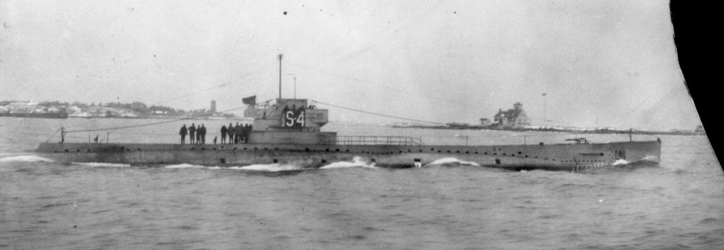
USS S-4 (SS-109)
USS ''S-4'' (SS-109) was an S-class submarine of the United States Navy. In 1927, she was sunk by being accidentally rammed by a United States Coast Guard destroyer with the loss of all hands but was raised and restored to service until stricken in 1936. Construction ''S-4''s keel was laid down on 4 December 1917 by the Portsmouth Navy Yard in Portsmouth, New Hampshire, and Kittery, Maine. She was launched on 27 August 1919 sponsored by Mrs. Herbert S. Howard, and commissioned on 19 November 1919. Service Following acceptance trials, a visit to Havana, Cuba from 14 to 19 January 1920, and subsequent operations along the Gulf of Mexico and New England coasts, ''S-4'' departed New London, Connecticut on 18 November to rendezvous off New Hampshire with her assigned unit – Submarine Divisions 12 ( SubDiv 12) – and SubDiv 18. The two divisions were about to embark on a historic voyage which, at that time, was to be the longest cruise undertaken by American submarines. Assigne ... [...More Info...] [...Related Items...] OR: [Wikipedia] [Google] [Baidu] |
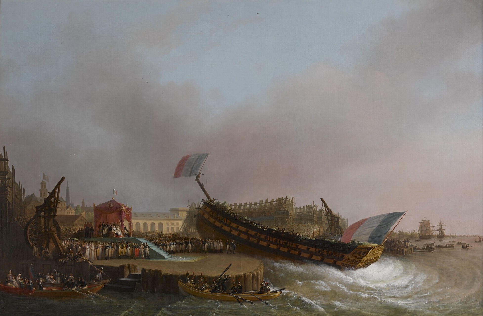
Ship Naming And Launching
Ceremonial ship launching involves the performing of ceremonies associated with the process of transferring a vessel to the water. It is a nautical tradition in many cultures, dating back millennia, to accompany the physical process with ceremonies which have been observed as public celebration and a solemn blessing, usually but not always, in association with the launch itself. Ship launching imposes stresses on the ship not met during normal operation and in addition to the size and weight of the vessel represents a considerable engineering challenge as well as a public spectacle. The process also involves many traditions intended to invite good luck, such as christening by breaking a sacrificial bottle of champagne over the bow as the ship is named aloud and launched. Methods There are three principal methods of conveying a new ship from building site to water, only two of which are called "launching". The oldest, most familiar, and most widely used is the end-on la ... [...More Info...] [...Related Items...] OR: [Wikipedia] [Google] [Baidu] |
Panama Canal
The Panama Canal () is an artificial waterway in Panama that connects the Caribbean Sea with the Pacific Ocean. It cuts across the narrowest point of the Isthmus of Panama, and is a Channel (geography), conduit for maritime trade between the Atlantic and Pacific Oceans. Lock (water navigation), Locks at each end lift ships up to Gatun Lake, an artificial fresh water lake Above mean sea level, above sea level, created by damming the Chagres River and Lake Alajuela to reduce the amount of excavation work required for the canal. Locks then lower the ships at the other end. An average of of fresh water is used in a single passing of a ship. The canal is threatened by low water levels during droughts. The Panama Canal shortcut greatly reduces the time for ships to travel between the Atlantic and Pacific oceans, enabling them to avoid the lengthy, hazardous route around the southernmost tip of South America via the Drake Passage, the Strait of Magellan or the Beagle Channel. Its ... [...More Info...] [...Related Items...] OR: [Wikipedia] [Google] [Baidu] |
Philippine Islands
The Philippines, officially the Republic of the Philippines, is an Archipelagic state, archipelagic country in Southeast Asia. Located in the western Pacific Ocean, it consists of List of islands of the Philippines, 7,641 islands, with a total area of roughly 300,000 square kilometers, which are broadly categorized in Island groups of the Philippines, three main geographical divisions from north to south: Luzon, Visayas, and Mindanao. With a population of over 110 million, it is the world's List of countries and dependencies by population, twelfth-most-populous country. The Philippines is bounded by the South China Sea to the west, the Philippine Sea to the east, and the Celebes Sea to the south. It shares maritime borders with Taiwan to the north, Japan to the northeast, Palau to the east and southeast, Indonesia to the south, Malaysia to the southwest, Vietnam to the west, and China to the northwest. It has Ethnic groups in the Philippines, diverse ethnicities and Culture o ... [...More Info...] [...Related Items...] OR: [Wikipedia] [Google] [Baidu] |
Cavite
Cavite, officially the Province of Cavite (; Chavacano: ''Provincia de Cavite''), is a Provinces of the Philippines, province of the Philippines located in the Calabarzon region. On the southern shores of Manila Bay and southwest of Manila, it is one of the most industrialized and fastest-growing provinces in the Philippines. As of 2020, Cavite is one of the List of Philippine provinces by population, largest province in the country in terms of population, which had 4,344,829 people if the Cities of the Philippines, independent cities of Cebu are excluded from Cebu's population figure. The ''de facto'' capital and seat of the government of the province is Trece Martires, although Imus is the official (''de jure'') capital while the Dasmariñas, City of Dasmariñas is the largest city in the province. For over 300 years, the province played an important role in both the country's colonial past and eventual fight for independence, earning it the title "Historical Capital of the ... [...More Info...] [...Related Items...] OR: [Wikipedia] [Google] [Baidu] |
United States Asiatic Fleet
The United States Asiatic Fleet was a fleet of the United States Navy during much of the first half of the 20th century. Before World War II, the fleet patrolled the Philippine Islands. Much of the fleet was destroyed by the Japanese by February 1942, after which it was dissolved, and the remnants incorporated into the naval component of the South West Pacific Area command, which eventually became the Seventh Fleet. The fleet was created when its predecessor, the Asiatic Squadron, was upgraded to fleet status in 1902. In early 1907, the fleet was downgraded and became the First Squadron of the United States Pacific Fleet. However, on 28 January 1910, it was again organized as the Asiatic Fleet. Thus constituted, the Asiatic Fleet, based in the Philippines, was organizationally independent of the Pacific Fleet, which was based on the United States West Coast until it moved to Pearl Harbor in the Territory of Hawaii in 1940. Although much smaller than any other U.S. Navy fleet ... [...More Info...] [...Related Items...] OR: [Wikipedia] [Google] [Baidu] |
Flotilla
A flotilla (from Spanish, meaning a small ''flota'' ( fleet) of ships), or naval flotilla, is a formation of small warships that may be part of a larger fleet. Composition A flotilla is usually composed of a homogeneous group of the same class of warship, such as frigates, destroyers, torpedo boats, submarines, gunboats, or minesweepers. Groups of larger warships are usually called squadrons, but similar units of non-capital ships may be called squadrons in some instances, and flotillas in others. Formations including more than one capital ship, e.g. men-of-war, battleships, and aircraft carriers, typically alongside smaller ships and support craft, are typically called fleets, each portion led by a capital ship being a squadron or task force. A flotilla is usually commanded by a rear admiral, a commodore or a captain, depending on the importance of the command (a vice admiral would normally command a squadron). A flotilla is often divided into two or more divisions, ... [...More Info...] [...Related Items...] OR: [Wikipedia] [Google] [Baidu] |
SubDiv
A submarine squadron (SUBRON) is a naval formation or unit in such states such as the United Kingdom, United States, and Russia/Soviet Union. In France the equivalent unit is the ' (ESNA), part of the French submarine forces (and before the Second World War, '). Royal Navy Submarine flotillas became submarine divisions in 1952. was a ''Porpoise''-class submarine belonging first to Faslane's 3rd Submarine Squadron and then to Singapore's 7th Submarine Squadron (United Kingdom). From the early 1960s the structure was: *1st Submarine Squadron – *2nd Submarine Squadron – Plymouth *3rd Submarine Squadron – Faslane *4th Submarine Division – Sydney (established 1948, disbanded 1969) *5th Submarine Division – Malta. It was announced on 31 July 1964, that British submarines were to leave Malta. Captain C.H. Hammer was last Captain S.M. 5. HMS ''Ausonia'', the division depot ship, set sail for the UK on 7 August 1964, and then paid off. Submarine depot ships at Malta were ''F ... [...More Info...] [...Related Items...] OR: [Wikipedia] [Google] [Baidu] |
New Hampshire
New Hampshire ( ) is a U.S. state, state in the New England region of the Northeastern United States. It borders Massachusetts to the south, Vermont to the west, Maine and the Gulf of Maine to the east, and the Canadian province of Quebec to the north. Of the List of states and territories of the United States, 50 U.S. states, New Hampshire is the List of U.S. states and territories by area, seventh-smallest by land area and the List of U.S. states and territories by population, tenth-least populous, with a population of 1,377,529 residents as of the 2020 United States census, 2020 census. Concord, New Hampshire, Concord is the List of capitals in the United States, state capital and Manchester, New Hampshire, Manchester is the List of municipalities in New Hampshire, most populous city. New Hampshire's List of U.S. state mottos, motto, "Live Free or Die", reflects its role in the American Revolutionary War; its state nickname, nickname, "The Granite State", refers to its ext ... [...More Info...] [...Related Items...] OR: [Wikipedia] [Google] [Baidu] |
New London, Connecticut
New London is a seaport city and a port of entry on the northeast coast of the United States, located at the outlet of the Thames River (Connecticut), Thames River in New London County, Connecticut, which empties into Long Island Sound. The city is part of the Southeastern Connecticut Planning Region, Connecticut, Southeastern Connecticut Planning Region. New London is home to the United States Coast Guard Academy, Connecticut College, Mitchell College, and The Williams School. The Coast Guard Station New London and New London Harbor is home port to both the Coast Guard's Cutter (boat), cutter ''Coho'' and their tall ship USCGC Eagle (WIX-327), ''Eagle''. The city had a population of 27,367 at the 2020 census. The Norwich, Connecticut, Norwich–New London metropolitan area includes 21 towns and 274,055 people. History Colonial era The area was called Nameaug by the Pequot Native Americans of the United States, Indians. John Winthrop, Jr. founded the first English settlemen ... [...More Info...] [...Related Items...] OR: [Wikipedia] [Google] [Baidu] |
New England
New England is a region consisting of six states in the Northeastern United States: Connecticut, Maine, Massachusetts, New Hampshire, Rhode Island, and Vermont. It is bordered by the state of New York (state), New York to the west and by the Canadian provinces of New Brunswick to the northeast and Quebec to the north. The Gulf of Maine and Atlantic Ocean are to the east and southeast, and Long Island Sound is to the southwest. Boston is New England's largest city and the capital of Massachusetts. Greater Boston, comprising the Boston–Worcester–Providence Combined Statistical Area, houses more than half of New England's population; this area includes Worcester, Massachusetts, the second-largest city in New England; Manchester, New Hampshire, the largest city in New Hampshire; and Providence, Rhode Island, the capital of and largest city in Rhode Island. In 1620, the Pilgrims (Plymouth Colony), Pilgrims established Plymouth Colony, the second successful settlement in Briti ... [...More Info...] [...Related Items...] OR: [Wikipedia] [Google] [Baidu] |
Gulf Of Mexico
The Gulf of Mexico () is an oceanic basin and a marginal sea of the Atlantic Ocean, mostly surrounded by the North American continent. It is bounded on the northeast, north, and northwest by the Gulf Coast of the United States; on the southwest and south by the Mexican states of Tamaulipas, Veracruz, Tabasco, Campeche, Yucatán, and Quintana Roo; and on the southeast by Cuba. The coastal areas along the Southern U.S. states of Texas, Louisiana, Mississippi, Alabama, and Florida, which border the Gulf on the north, are occasionally referred to as the "Third Coast" of the United States (in addition to its Atlantic and Pacific coasts), but more often as "the Gulf Coast". The Gulf of Mexico took shape about 300 million years ago (mya) as a result of plate tectonics. The Gulf of Mexico basin is roughly oval and is about wide. Its floor consists of sedimentary rocks and recent sediments. It is connected to part of the Atlantic Ocean through the Straits of Florida between the ... [...More Info...] [...Related Items...] OR: [Wikipedia] [Google] [Baidu] |


