|
Thin-skinned Deformation
Thin-skinned deformation is a style of deformation in plate tectonics at a convergent boundary which occurs with shallow thrust faults that only involves cover rocks (typically sedimentary rocks), and not deeper basement rocks. The thin-skinned style of deformation is typical of many fold and thrust belts developed in the foreland of a collisional zone or back arc of a continental volcanic arc. This is particularly the case where a good basal decollement exists, usually in a weaker layer like a shale, evaporite, or a zone of high pore fluid pressure. This was first described in Rocky Mountains of the United States, as part of the Sevier Orogeny. Rubey. W. and Hubbert. M. Role of fluid pressure in mechanics of overthrust faulting II. Overthrust belt in geosynclinal area of western Wyoming in light of fluid-pressure hypothesis. Bulletin of the Geological Society of America, 1959. v. 70. p. 167-206. In the rock record, this will increase the influence of more surficial rocks, ... [...More Info...] [...Related Items...] OR: [Wikipedia] [Google] [Baidu] |
Shale
Shale is a fine-grained, clastic sedimentary rock formed from mud that is a mix of flakes of Clay mineral, clay minerals (hydrous aluminium phyllosilicates, e.g., Kaolinite, kaolin, aluminium, Al2Silicon, Si2Oxygen, O5(hydroxide, OH)4) and tiny fragments (silt-sized particles) of other minerals, especially quartz and calcite.Blatt, Harvey and Robert J. Tracy (1996) ''Petrology: Igneous, Sedimentary and Metamorphic'', 2nd ed., Freeman, pp. 281–292 Shale is characterized by its tendency to split into thin layers (Lamination (geology), laminae) less than one centimeter in thickness. This property is called ''Fissility (geology), fissility''. Shale is the most common sedimentary rock. The term ''shale'' is sometimes applied more broadly, as essentially a synonym for mudrock, rather than in the narrower sense of clay-rich fissile mudrock. Texture Shale typically exhibits varying degrees of fissility. Because of the parallel orientation of clay mineral flakes in shale, it breaks in ... [...More Info...] [...Related Items...] OR: [Wikipedia] [Google] [Baidu] |
Thick-skinned Deformation
Thick-skinned deformation is a geological term which refers to crustal shortening that involves basement rocks and deep-seated faults as opposed to only the upper units of cover rocks above the basement which is known as thin-skinned deformation. While thin-skinned deformation is common in many different localities, thick-skinned deformation requires much more strain to occur and is a rarer type of deformation. Definition Different processes can deform rocks, the deformation is almost always the result of stress. This stress leads to the formation of fault and fold structures, both can either extend or shorten of the Earth's crust. Thick-skinned deformation specifically affects deep crystalline rock of the basement and may extend deeper into the lower crust. Thin-skinned deformation affects the upper crustal layers and does not deform the deeper basement. Causes Thick-skinned deformation is most commonly a result of crustal shortening and occurs when the region is undergoin ... [...More Info...] [...Related Items...] OR: [Wikipedia] [Google] [Baidu] |
Lithic Sandstone
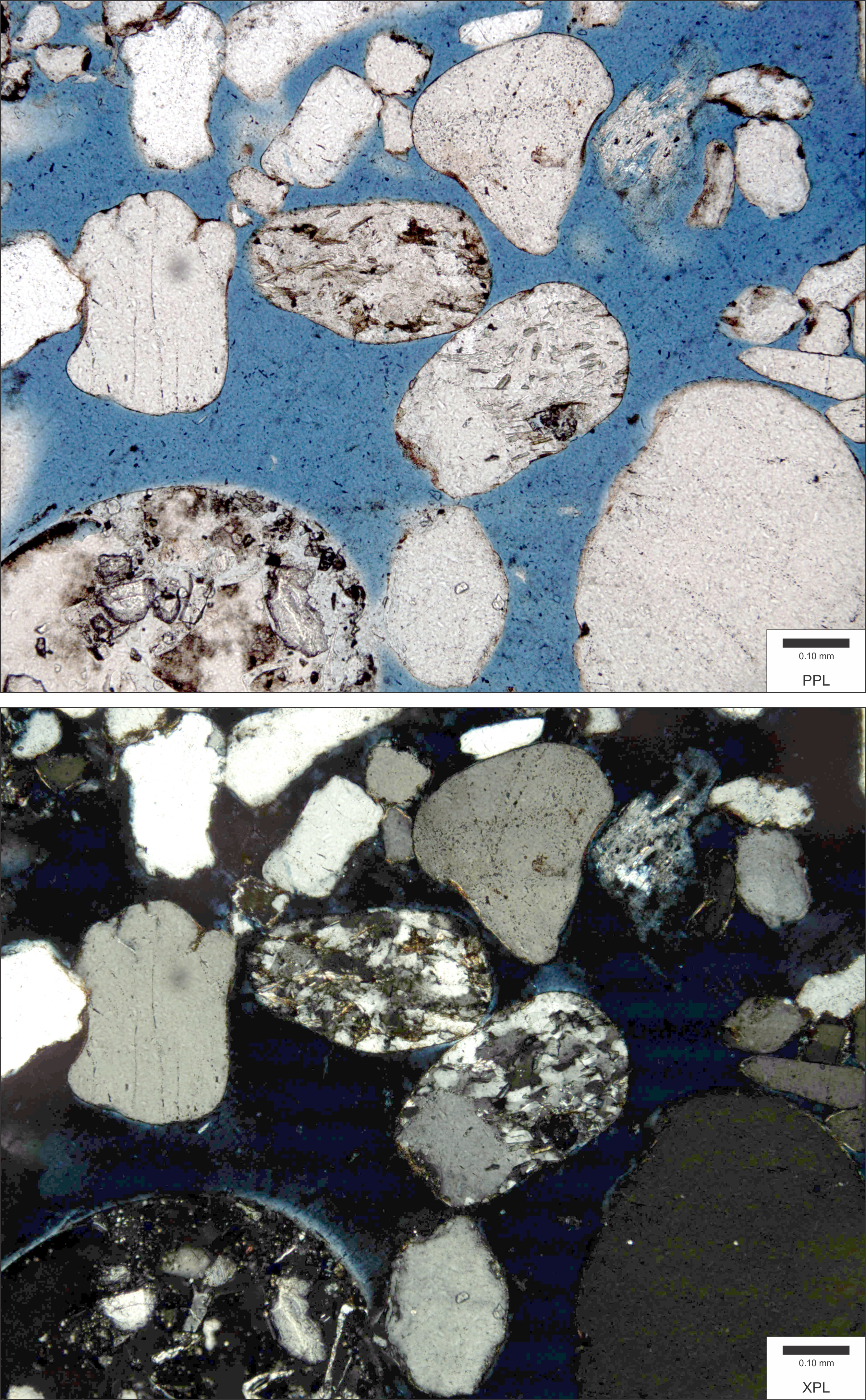
Lithic sandstones, or lithic arenites, or litharenites, are sandstones with a significant (>5%) component of lithic fragments, though quartz and feldspar are usually present as well, along with some clayey matrix. Lithic sandstones can have a speckled (salt and pepper) or gray color, and are usually associated with one specific type of lithic fragment (i.e., igneous, sedimentary, or metamorphic).Prothero, D. R. and Schwab, F., 1996, Sedimentary Geology, pg. 100, Tectonically, lithic sandstones often form in a wide variety sedimentary depositional environments (including fluvial, deltaic, and alluvial sediments) associated with active margins. This tectonic Tectonics ( via Latin ) are the processes that result in the structure and properties of the Earth's crust and its evolution through time. The field of ''planetary tectonics'' extends the concept to other planets and moons. These processes ... setting provides the source of the lithic fragments, either through ... [...More Info...] [...Related Items...] OR: [Wikipedia] [Google] [Baidu] |
Sevier Orogeny
The Sevier orogeny was a mountain-building event that affected western North America from northern Canada to the north to Mexico to the south. The Sevier orogeny was the result of convergent boundary tectonic activity, and deformation occurred from approximately 160 million years (Ma) ago to around 50 Ma. This orogeny was caused by the subduction of the oceanic Farallon Plate underneath the continental North American Plate. Crustal thickening that led to mountain building was caused by a combination of compressive forces and conductive heating initiated by subduction, which led to deformation. The Sevier River area of central Utah is the namesake of this event. Extent The Sevier Fold and Thrust Belt extends from southern California near the Mexican border to Canada. Basin and Range faults cut the older Sevier thrust faults. The Sevier orogeny was preceded by several other mountain-building events including the Nevadan orogeny, the Sonoman orogeny, and the Antler orogeny, ... [...More Info...] [...Related Items...] OR: [Wikipedia] [Google] [Baidu] |
United States
The United States of America (USA), also known as the United States (U.S.) or America, is a country primarily located in North America. It is a federal republic of 50 U.S. state, states and a federal capital district, Washington, D.C. The 48 contiguous states border Canada to the north and Mexico to the south, with the semi-exclave of Alaska in the northwest and the archipelago of Hawaii in the Pacific Ocean. The United States asserts sovereignty over five Territories of the United States, major island territories and United States Minor Outlying Islands, various uninhabited islands in Oceania and the Caribbean. It is a megadiverse country, with the world's List of countries and dependencies by area, third-largest land area and List of countries and dependencies by population, third-largest population, exceeding 340 million. Its three Metropolitan statistical areas by population, largest metropolitan areas are New York metropolitan area, New York, Greater Los Angeles, Los Angel ... [...More Info...] [...Related Items...] OR: [Wikipedia] [Google] [Baidu] |
Rocky Mountains
The Rocky Mountains, also known as the Rockies, are a major mountain range and the largest mountain system in North America. The Rocky Mountains stretch in great-circle distance, straight-line distance from the northernmost part of Western Canada, to New Mexico in the Southwestern United States. Depending on differing definitions between Canada and the U.S., its northern terminus is located either in northern British Columbia's Terminal Range south of the Liard River and east of Rocky Mountain Trench, the Trench, or in the northeastern foothills of the Brooks Range/British Mountains that face the Beaufort Sea coasts between the Canning River (Alaska), Canning River and the Firth River across the Alaska-Yukon border. Its southernmost point is near the Albuquerque metropolitan area, Albuquerque area adjacent to the Rio Grande rift and north of the Sandia–Manzano Mountains, Sandia–Manzano Mountain Range. Being the easternmost portion of the North American Cordillera, the Rockie ... [...More Info...] [...Related Items...] OR: [Wikipedia] [Google] [Baidu] |
Evaporite
An evaporite () is a water- soluble sedimentary mineral deposit that results from concentration and crystallization by evaporation from an aqueous solution. There are two types of evaporite deposits: marine, which can also be described as ocean deposits, and non-marine, which are found in standing bodies of water such as lakes. Evaporites are considered sedimentary rocks and are formed by chemical sediments. Formation Although all water bodies on the surface and in aquifers contain dissolved salts, the water must evaporate into the atmosphere for the minerals to precipitate. For this to happen, the water body must enter a restricted environment where water input into this environment remains below the net rate of evaporation. This is usually an arid environment with a small drainage basin fed by a limited input of water. When evaporation occurs, the remaining water is enriched in salts, and they precipitate after the water becomes saturated. Depositional environments ... [...More Info...] [...Related Items...] OR: [Wikipedia] [Google] [Baidu] |
Deformation (engineering)
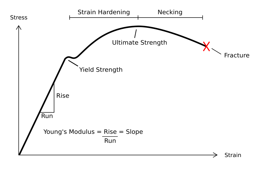
In engineering, deformation (the change in size or shape of an object) may be ''elastic'' or ''plastic''. If the deformation is negligible, the object is said to be ''rigid''. Main concepts Occurrence of deformation in engineering applications is based on the following background concepts: * ''Displacements'' are any change in position of a point on the object, including whole-body translations and rotations ( rigid transformations). * ''Deformation'' are changes in the relative position between internals points on the object, excluding rigid transformations, causing the body to change shape or size. * ''Strain'' is the ''relative'' ''internal'' deformation, the dimensionless change in shape of an infinitesimal cube of material relative to a reference configuration. Mechanical strains are caused by mechanical stress, ''see stress-strain curve''. The relationship between stress and strain is generally linear and reversible up until the yield point and the deformation is ... [...More Info...] [...Related Items...] OR: [Wikipedia] [Google] [Baidu] |
Volcanic Arc
A volcanic arc (also known as a magmatic arc) is a belt of volcanoes formed above a subducting oceanic tectonic plate, with the belt arranged in an arc shape as seen from above. Volcanic arcs typically parallel an oceanic trench, with the arc located further from the subducting plate than the trench. The oceanic plate is saturated with water, mostly in the form of hydrous minerals such as micas, amphiboles, and serpentines. As the oceanic plate is subducted, it is subjected to increasing pressure and temperature with increasing depth. The heat and pressure break down the hydrous minerals in the plate, releasing water into the overlying mantle. Volatiles such as water drastically lower the melting point of the mantle, causing some of the mantle to melt and form magma at depth under the overriding plate. The magma ascends to form an arc of volcanoes parallel to the subduction zone. Volcanic arcs are distinct from volcanic chains formed over hotspots in the middle of a tecton ... [...More Info...] [...Related Items...] OR: [Wikipedia] [Google] [Baidu] |
Fold And Thrust Belt
A fold and thrust belt is a series of mountainous foothills adjacent to an orogenic belt, which forms due to contractional tectonics. Fold and thrust belts commonly form in the forelands adjacent to major orogens as deformation propagates outwards. Fold and thrust belts usually comprise both folds and thrust fault A thrust fault is a break in the Earth's crust, across which older rocks are pushed above younger rocks. Thrust geometry and nomenclature Reverse faults A thrust fault is a type of reverse fault that has a dip of 45 degrees or less. I ...s, commonly interrelated. They are commonly also known as thrust-and-fold belts, or simply thrust-fold belts. Geometry Fold and thrust belts are formed of a series of sub-parallel thrust sheets, separated by major thrust faults. As the total shortening increases in a fold and thrust belt, the belt propagates into its foreland. New thrusts develop at the front of the belt, folding the older thrusts that have become inactiv ... [...More Info...] [...Related Items...] OR: [Wikipedia] [Google] [Baidu] |


