|
SĂžgneelva
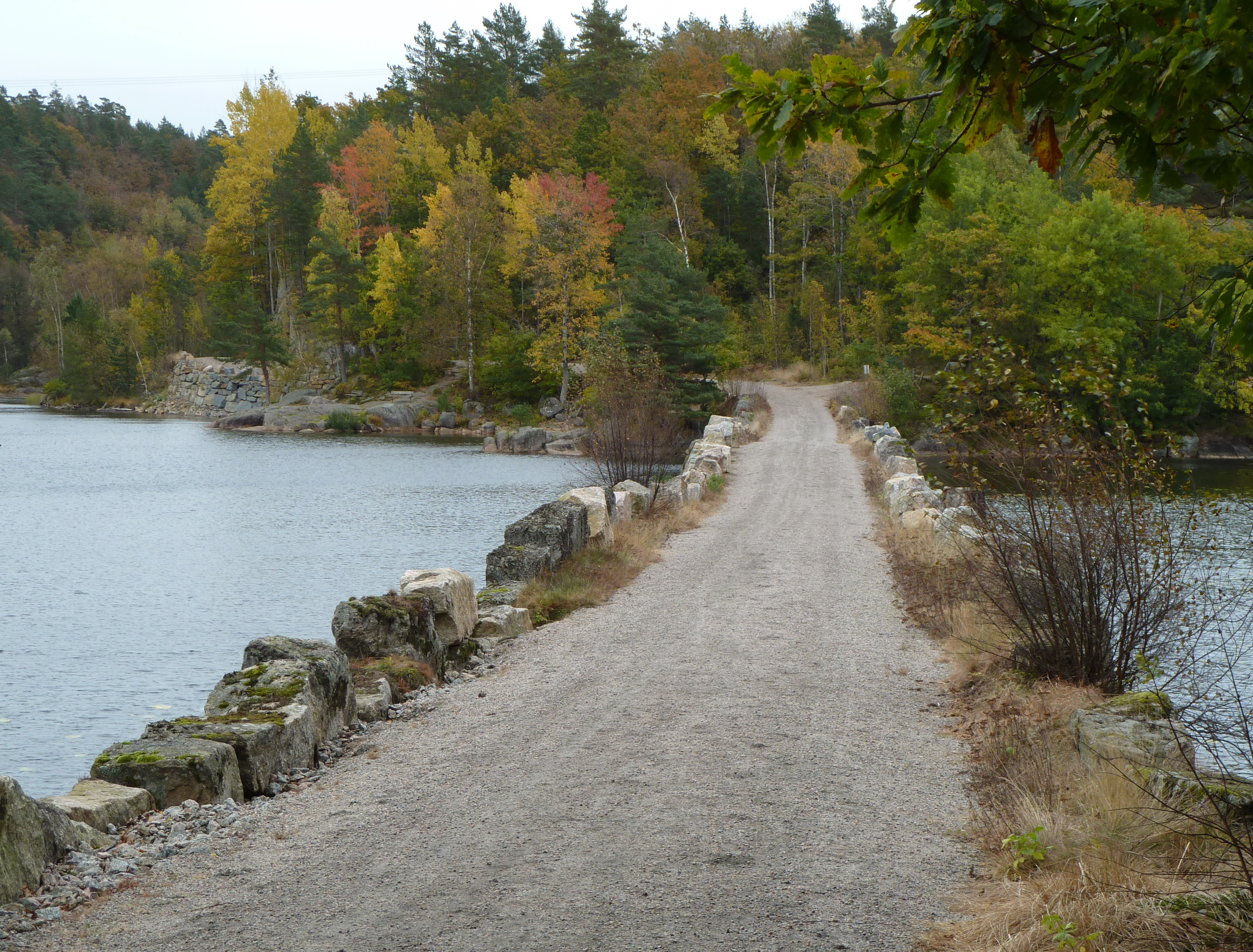
Songdalselva or SÞgneelva or Songa is a river in Agder county, Norway. The long river in the hills between Finsland in Kristiansand municipality and HÊgeland in Vennesla municipality. The catchment area is located between the Otra river and Mandalselva river watersheds. The river runs through the villages of Hortemo, Nodeland, Volleberg, Tangvall, à ros, and HÞllen. The highest hills in the catchment area go up to above sea level. The water flows are normally at their lowest in the summer and they're at their highest levels during the autumn and spring. There are only a few small lakes in the river system. The steep slopes down from the moors can create short and intense flood rapids. The river (here called ''Songa'') flows through the Stallemodalen valley in Vennesla, and then falls into the Songdalen valley through a gorge at UnderÄsen. Once in the Songdalen valley, it is called the ''Songdalselva''. Here it receives more water from the right from the Gumpe ... [...More Info...] [...Related Items...] OR: [Wikipedia] [Google] [Baidu] |
Ă
ros, SĂžgne
Ă ros is a village in Kristiansand municipality in Agder county, Norway. The village is located along the river SĂžgneelva between the village of HĂžllen to the west and Langenes to the east. The west side of Ă ros reaches the HĂžllefjorden. Ă ros Feriesenter is a large recreational area along the fjord. It includes a camping facility and a beach area that is a popular attraction in the summer for residents and tourists alike. Ă rosskogen is the main residential neighborhood in the village. As a part of the greater SĂžgne urban area in Kristiansand, separate population statistics are not tracked for Ă ros. Altogether, the urban area has a population (2015) of 9,147 which gives it a population density Population density (in agriculture: Standing stock (other), standing stock or plant density) is a measurement of population per unit land area. It is mostly applied to humans, but sometimes to other living organisms too. It is a key geog ... of . References Ext ... [...More Info...] [...Related Items...] OR: [Wikipedia] [Google] [Baidu] |
Songdalen
Songdalen is a List of former municipalities of Norway, former municipality in the old Vest-Agder county, Norway. The municipality existed from 1964 until 2020 when it was merged with SÞgne and Kristiansand municipalities to form a new, much larger Kristiansand municipality in what is now Agder county. It was located in the Traditional districts of Norway, traditional district of SÞrlandet, just outside of the city of Kristiansand (town), Kristiansand. The administrative centre of the municipality was the village of Nodeland. Other villages in the municipality included BrennÄsen, Finsland, Kilen, Vest-Agder, Kilen, Nodelandsheia, and Volleberg. The SÞrlandsbanen railway line ran through the municipality, stopping at Nodeland Station. The European route E39 highway also ran through the southern part of the municipality. Prior to its dissolution in 2020, the municipality is the 323rd largest by area out of the 422 municipalities in Norway. Songdalen is the 161st most populous ... [...More Info...] [...Related Items...] OR: [Wikipedia] [Google] [Baidu] |
HĂžllen
HĂžllen is a fishing village in Kristiansand municipality in Agder county, Norway. The village is located at the mouth of the river SĂžgneelva, between the villages of Eig to the west, Tangvall to the north, and Ă ros to the east. HĂžllen is part of the greater SĂžgne urban area. It has a well-protected harbour and over the centuries has had shipyards, a post office, and it was the site of a Thing in the 1500s. There is regular ferry boat service to Ny-Hellesund from HĂžllen. As a part of the greater SĂžgne urban area in Kristiansand, separate population statistics are not tracked for HĂžllen. Altogether, the urban area has a population (2015) of 9,147 which gives it a population density Population density (in agriculture: Standing stock (other), standing stock or plant density) is a measurement of population per unit land area. It is mostly applied to humans, but sometimes to other living organisms too. It is a key geog ... of . References Villages i ... [...More Info...] [...Related Items...] OR: [Wikipedia] [Google] [Baidu] |
Tangvall
Tangvall is a village in Kristiansand municipality in Agder county, Norway. It was the administrative centre of the old SĂžgne municipality which existed until 2020. The village is located along the European route E39 highway and the river SĂžgneelva. The village sits just north of Ă ros and HĂžllen, northeast of the village of Eig, and east of the village of Lunde. Together, Tangvall, Lunde, HĂžllen, Eig, Ă ros, and Langenes all form one large urban area known as ''SĂžgne''. The urban area has a population (2015) of 9,147 a population density Population density (in agriculture: Standing stock (other), standing stock or plant density) is a measurement of population per unit land area. It is mostly applied to humans, but sometimes to other living organisms too. It is a key geog ... of . The Old SĂžgne Church is located in the southeastern part of the urban area, just north of Ă ros and Langenes. The "new" SĂžgne Church is located in Lunde. The municipal governmen ... [...More Info...] [...Related Items...] OR: [Wikipedia] [Google] [Baidu] |
Rivers Of Agder
A river is a natural stream of fresh water that flows on land or inside caves towards another body of water at a lower elevation, such as an ocean, lake, or another river. A river may run dry before reaching the end of its course if it runs out of water, or only flow during certain seasons. Rivers are regulated by the water cycle, the processes by which water moves around the Earth. Water first enters rivers through precipitation, whether from rainfall, the runoff of water down a slope, the melting of glaciers or snow, or seepage from aquifers beneath the surface of the Earth. Rivers flow in channeled watercourses and merge in confluences to form drainage basins, or catchments, areas where surface water eventually flows to a common outlet. Rivers have a great effect on the landscape around them. They may regularly overflow their banks and flood the surrounding area, spreading nutrients to the surrounding area. Sediment or alluvium carried by rivers shapes the landscape ar ... [...More Info...] [...Related Items...] OR: [Wikipedia] [Google] [Baidu] |
Hydropower
Hydropower (from Ancient Greek -, "water"), also known as water power or water energy, is the use of falling or fast-running water to Electricity generation, produce electricity or to power machines. This is achieved by energy transformation, converting the Potential energy, gravitational potential or kinetic energy of a water source to produce power. Hydropower is a method of sustainable energy production. Hydropower is now used principally for Hydroelectricity, hydroelectric power generation, and is also applied as one half of an energy storage system known as pumped-storage hydroelectricity. Hydropower is an attractive alternative to fossil fuels as it does not directly produce Carbon dioxide in Earth's atmosphere, carbon dioxide or other Air pollution, atmospheric pollutants and it provides a relatively consistent source of power. Nonetheless, it has economic, sociological, and environmental downsides and requires a sufficiently energetic source of water, such as a river or ... [...More Info...] [...Related Items...] OR: [Wikipedia] [Google] [Baidu] |
Plastic Waste
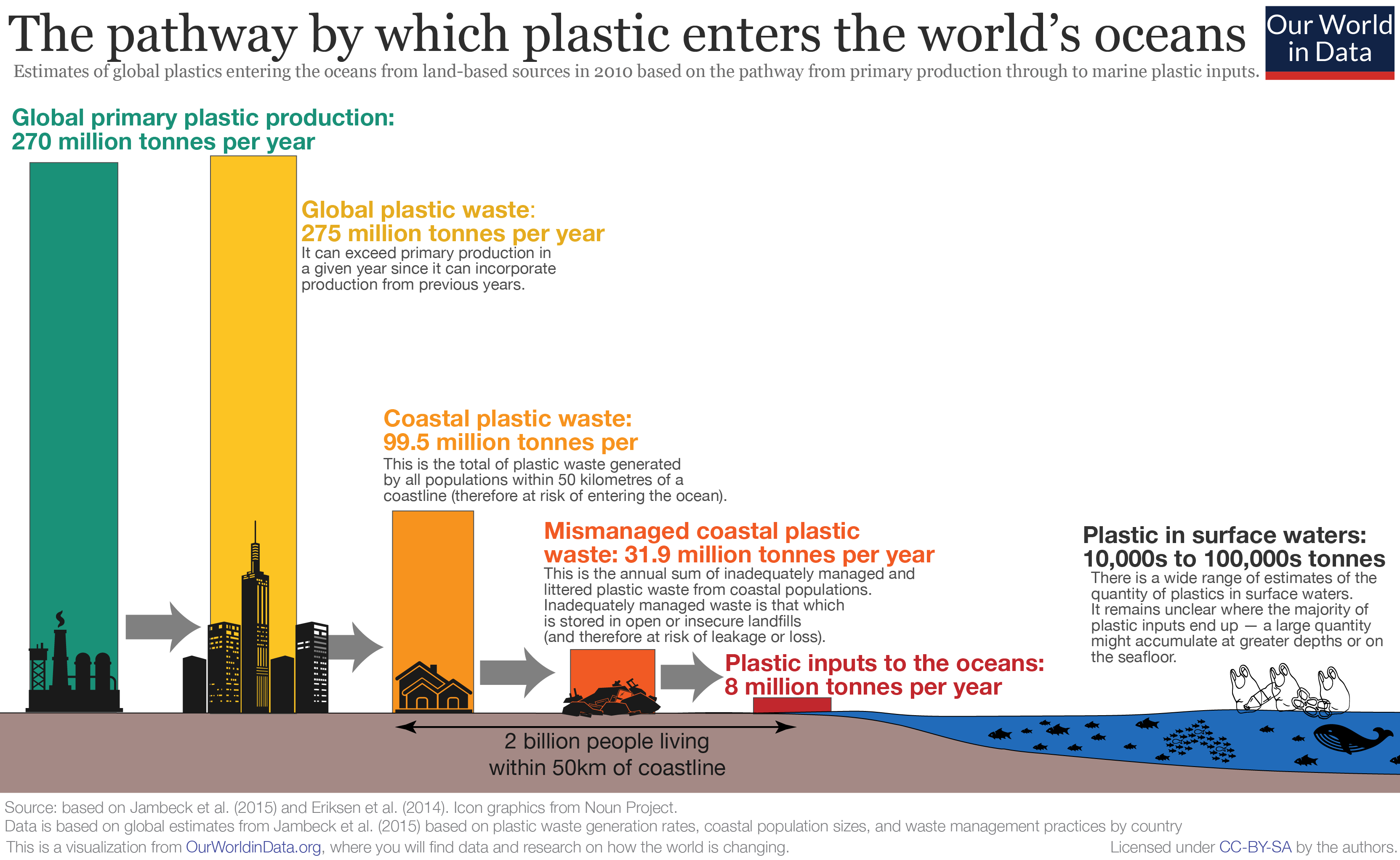
Plastic pollution is the accumulation of plastic objects and particles (e.g. plastic bottles, bags and microbeads) in the Earth's environment that adversely affects humans, wildlife and their habitat. Plastics that act as pollutants are categorized by size into micro-, meso-, or macro debris. Plastics are inexpensive and durable, making them very adaptable for different uses; as a result, manufacturers choose to use plastic over other materials. However, the chemical structure of most plastics renders them resistant to many natural processes of degradation and as a result they are slow to degrade. Together, these two factors allow large volumes of plastic to enter the environment as mismanaged waste which persists in the ecosystem and travels throughout food webs. Plastic pollution can afflict land, waterways and oceans. It is estimated that 1.1 to 8.8'' ''million tonnes of plastic waste enters the ocean from coastal communities each year. It is estimated that there is ... [...More Info...] [...Related Items...] OR: [Wikipedia] [Google] [Baidu] |
Fishing
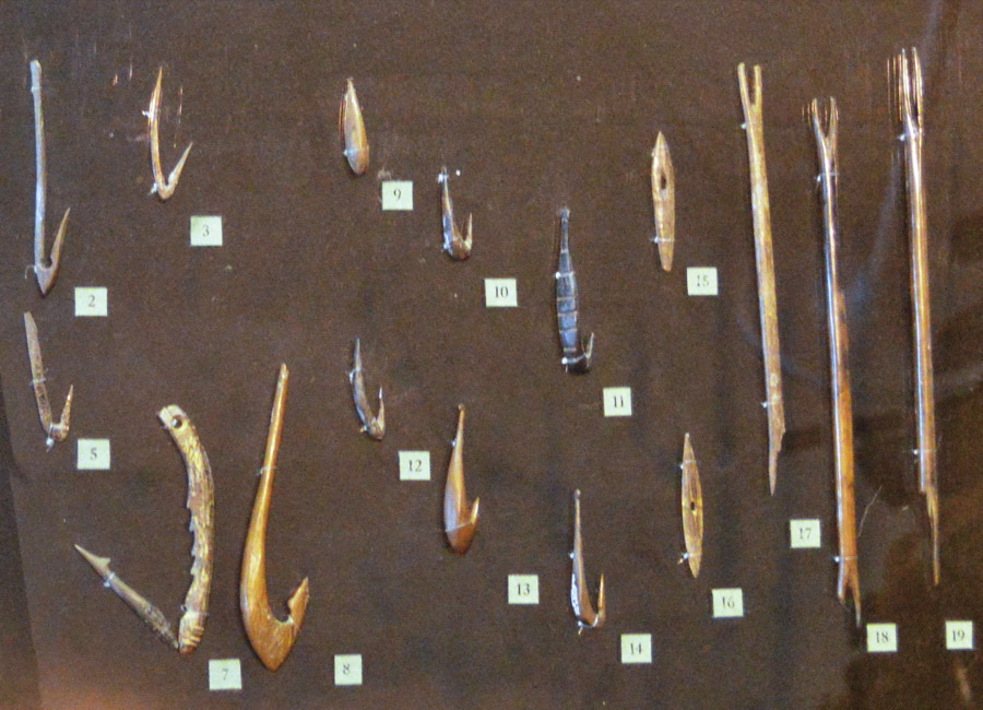
Fishing is the activity of trying to catch fish. Fish are often caught as wildlife from the natural environment (Freshwater ecosystem, freshwater or Marine ecosystem, marine), but may also be caught from Fish stocking, stocked Body of water, bodies of water such as Fish pond, ponds, canals, park wetlands and reservoirs. Fishing techniques include trawling, Longline fishing, longlining, jigging, Fishing techniques#Hand-gathering, hand-gathering, Spearfishing, spearing, Fishing net, netting, angling, Bowfishing, shooting and Fish trap, trapping, as well as Destructive fishing practices, more destructive and often Illegal, unreported and unregulated fishing, illegal techniques such as Electrofishing, electrocution, Blast fishing, blasting and Cyanide fishing, poisoning. The term fishing broadly includes catching aquatic animals other than fish, such as crustaceans (shrimp/lobsters/crabs), shellfish, cephalopods (octopus/squid) and echinoderms (starfish/sea urchins). The term is n ... [...More Info...] [...Related Items...] OR: [Wikipedia] [Google] [Baidu] |
Fishing License
A fishing license (American English, US), fishing licence (British English, UK), or fishing permit is an administrative or legal mechanism employed by state government, state and local governments to regulate fishing activities within their administrative areas. Licensing is one type of fisheries management commonly used in Western countries, and may be required for either commercial fishing, commercial or recreational fishing. Historical licensing In 1765, the Chinese Qing dynasty government required all fishing boat operators to obtain a fishing license under the ''aojia'' system that regulated coastal populations. The Tanka people, Dan boat people of Guangdong had to acquire a fishing license as early as 1729. The wooden license issued by the government was to be displayed on the bow or stern of a boat. The information on the license consisted of the name and age of the boat's owner, the ship's status as either a fishing or commercial vessel, the home port of the boat, cre ... [...More Info...] [...Related Items...] OR: [Wikipedia] [Google] [Baidu] |
Sea Trout
Sea trout is the common name usually applied to anadromous (sea-run) forms of brown trout (''Salmo trutta''), and is often referred to as ''Salmo trutta'' morpha ''trutta''. Other names for anadromous brown trout are bull trout, sewin (Wales), peel or peal (southwest England), mort (northwest England), finnock (Scotland), white trout (Ireland) and salmon trout (culinary). The term "sea trout" is also used to describe other anadromous salmonids, such as coho salmon (''Oncorhynchus kisutch''), coastal cutthroat trout (''Oncorhynchus clarkii clarkii''), brook trout (''Salvelinus fontinalis''), Arctic char (''Salvelinus alpinus alpinus'') and Dolly Varden (''Salvenlinus malma''). Even some non-salmonid fish species are also commonly known as sea trout, such as Northern pikeminnow (''Ptychocheilus oregonensis'') and members of the weakfish family (''Cynoscion''). Range Anadromous brown trout are widely distributed in Europe along the Atlantic and Baltic coasts, the United Kin ... [...More Info...] [...Related Items...] OR: [Wikipedia] [Google] [Baidu] |
Salmon
Salmon (; : salmon) are any of several list of commercially important fish species, commercially important species of euryhaline ray-finned fish from the genera ''Salmo'' and ''Oncorhynchus'' of the family (biology), family Salmonidae, native to tributary, tributaries of the North Atlantic (''Salmo'') and North Pacific (''Oncorhynchus'') basins. ''Salmon'' is a colloquial or common name used for fish in this group, but is not a scientific name. Other closely related fish in the same family include trout, Salvelinus, char, Thymallus, grayling, Freshwater whitefish, whitefish, lenok and Hucho, taimen, all coldwater fish of the subarctic and cooler temperate regions with some sporadic endorheic populations in Central Asia. Salmon are typically fish migration, anadromous: they hatch in the shallow gravel stream bed, beds of freshwater headstreams and spend their juvenile fish, juvenile years in rivers, lakes and freshwater wetlands, migrate to the ocean as adults and live like sea ... [...More Info...] [...Related Items...] OR: [Wikipedia] [Google] [Baidu] |
Ă
ros
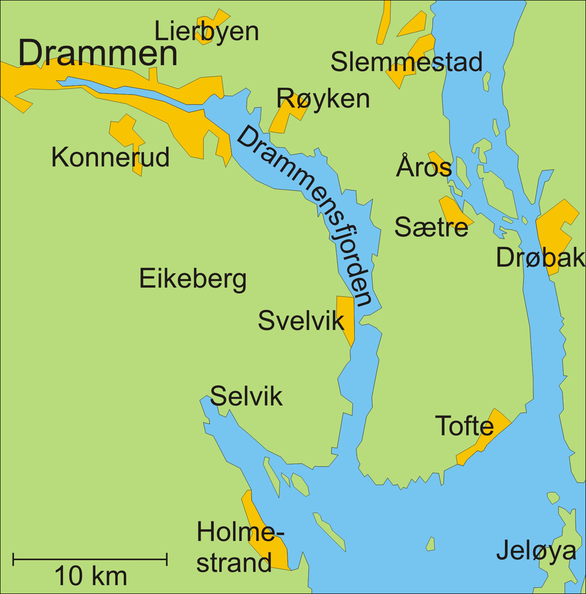
Ă ros is a village in RĂžyken in Asker (municipality), Asker municipality in Akershus, Akershus county, Norway. The population of Ă ros (2020) is about 2137. Location Ă ros is located on the peninsula of Hurumlandet along the western side of the Oslofjord. The river Ă roselva, which has long been a reliable source of power for sawmills, runs through the village. Ă ros is situated north of the village of SĂŠtre, Buskerud, SĂŠtre, about 40 km south of Oslo and 25 km southeast of Drammen. Norwegian County Road 11 (''Fylkesvei 11'') runs through Ă ros from Krokodden to SĂŠtre. The closest railway station is located at RĂžyken. Ă ros Church Ă ros is the location of Ă ros Church (''Ă ros kirke'') which dates from 1903. The chapel is constructed of wood after plans drawn by architect Alfred Christian Dahl. The building has a rectangular nave and 150 seats. Between 1963 and 1965, major improvements were implemented on the church. It is associated with the Diocese of Tunsber ... [...More Info...] [...Related Items...] OR: [Wikipedia] [Google] [Baidu] |


