|
Ă
ros
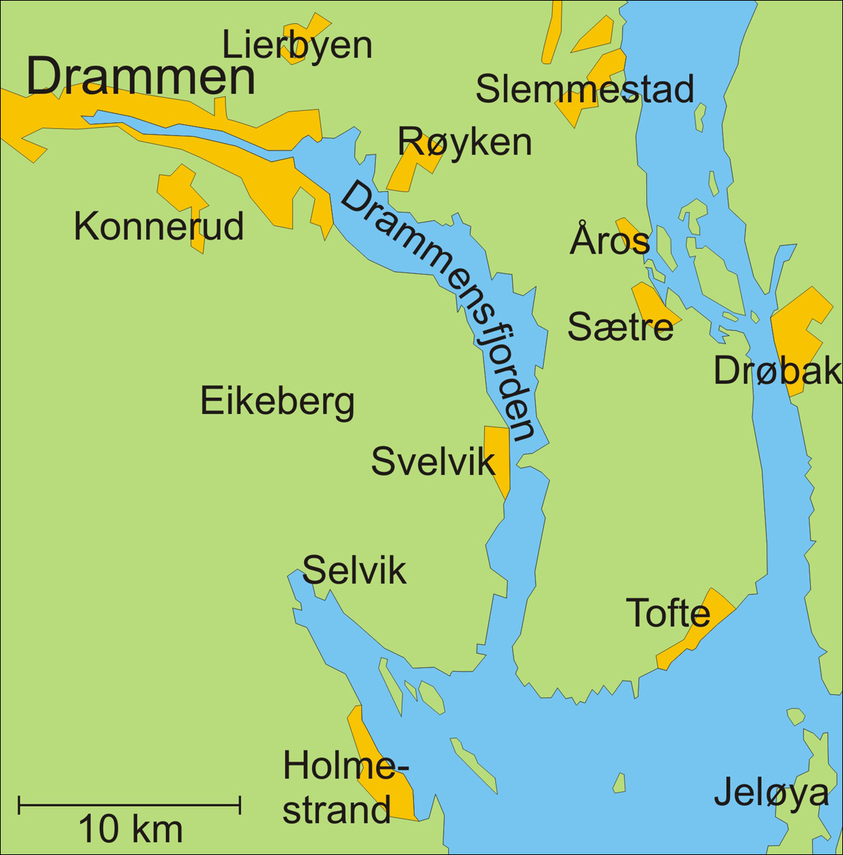
Ă ros is a village in RĂžyken in Asker (municipality), Asker municipality in Akershus, Akershus county, Norway. The population of Ă ros (2020) is about 2137. Location Ă ros is located on the peninsula of Hurumlandet along the western side of the Oslofjord. The river Ă roselva, which has long been a reliable source of power for sawmills, runs through the village. Ă ros is situated north of the village of SĂŠtre, Buskerud, SĂŠtre, about 40 km south of Oslo and 25 km southeast of Drammen. Norwegian County Road 11 (''Fylkesvei 11'') runs through Ă ros from Krokodden to SĂŠtre. The closest railway station is located at RĂžyken. Ă ros Church Ă ros is the location of Ă ros Church (''Ă ros kirke'') which dates from 1903. The chapel is constructed of wood after plans drawn by architect Alfred Christian Dahl. The building has a rectangular nave and 150 seats. Between 1963 and 1965, major improvements were implemented on the church. It is associated with the Diocese of Tunsber ... [...More Info...] [...Related Items...] OR: [Wikipedia] [Google] [Baidu] |
RĂžyken
RĂžyken is a district and village (''bygd'') and a former municipality in Buskerud in Viken County, Norway. In 2020 RĂžyken was merged with the municipalities of Hurum and Asker to form the new Asker Municipality (informally called "Greater Asker") located in the newly formed Viken county. The administrative centre of the municipality is the village of Midtbygda. The parish of ''RĂžken'' was established as a municipality on 1 January 1838 (see formannskapsdistrikt). Oslo ATCC, the Area Control Center for the controlled airspace above Ăstlandet is located here. General information Name The municipality (originally the parish) is named after the old ''RĂžyken'' farm ( Norse ''Raukvin''), since the first church was built there. The first element is ''raukr'' which means "pile, stack; mountain" and the last element is ''vin'' which means "meadow" or "pasture". Coat-of-arms The coat-of-arms is from modern times. They were granted on 15 December 1967. The figure shows a ye ... [...More Info...] [...Related Items...] OR: [Wikipedia] [Google] [Baidu] |
Drammensfjorden
Drammensfjord () is a fjord in along the border of Akershus and Buskerud counties in Norway that connects to Ytre Oslofjord on the west side. It stretches about to the north and northeast. The Drammenselva river discharges into the head of the fjord. The fjord shares its name with the city of Drammen, which is located at the head of the fjord. Drammen Municipality is located on its west and north sides. The land on the east side of the fjord is called ''HurumhalvĂžya'' or the Hurum peninsula and this is located in Asker Municipality. The peninsula lies between the Drammensfjord and the Oslofjord. The fjord narrows to a strait at Svelvik on the west side and Verket in Asker on the east side. The strait is crossed by an automobile ferry. This narrowing, some broad and deep, combined with the large freshwater inflow from the river Drammenselva (one of Norway's largest rivers) and from the river Lierelva, results in the water north of the strait being brackish. On the su ... [...More Info...] [...Related Items...] OR: [Wikipedia] [Google] [Baidu] |
Asker (municipality)
Asker Municipality is a municipality in Akershus county, Norway, that was established in 2020 by the merger of Asker in Akershus and RĂžyken and Hurum in Buskerud Buskerud () is a Counties of Norway, county and a current electoral district in Norway, bordering Akershus, Oslo, Innlandet, Vestland, Telemark and Vestfold. The region extends from the Oslofjord and Drammensfjorden in the southeast to Hardanger ... county. Asker proper (also called ''Askerbygda'') constitutes the northern fourth of the municipality, while RĂžyken and Hurum constitute the southern three quarters. It is part of the Greater Oslo Region. The administrative centre of the municipality is the town of Asker. " Notable people
|
Akershus
Akershus () is a county in Norway, with Oslo as its administrative centre, though Oslo is not located within Akershus. Akershus has been a region in Eastern Norway with Oslo as its main city since the Middle Ages, and is named after the Akershus Fortress in Oslo and ultimately after the medieval farm Aker in Oslo. From the Middle Ages to 1919, Akershus was a main fief and main county that included most of Eastern Norway, and from the 17th century until 2020 and again from 2024, Akershus also has a more narrow meaning as a smaller central county in the Greater Oslo Region. Akershus is Norway's largest county by population with over 716,000 inhabitants. Originally Akershus was one of four main fiefs in Norway and included almost all of Eastern Norway. The original Akershus became a main county (''Stiftamt'' or ''Stift'') in 1662 and was sometimes also known as ''Christiania Stift''. It included several subcounties (''Amt'' or ''Underamt''); in 1682 its most central areas, con ... [...More Info...] [...Related Items...] OR: [Wikipedia] [Google] [Baidu] |
Norway
Norway, officially the Kingdom of Norway, is a Nordic countries, Nordic country located on the Scandinavian Peninsula in Northern Europe. The remote Arctic island of Jan Mayen and the archipelago of Svalbard also form part of the Kingdom of Norway. Bouvet Island, located in the Subantarctic, is a Dependencies of Norway, dependency, and not a part of the Kingdom; Norway also Territorial claims in Antarctica, claims the Antarctic territories of Peter I Island and Queen Maud Land. Norway has a population of 5.6 million. Its capital and largest city is Oslo. The country has a total area of . The country shares a long eastern border with Sweden, and is bordered by Finland and Russia to the northeast. Norway has an extensive coastline facing the Skagerrak strait, the North Atlantic Ocean, and the Barents Sea. The unified kingdom of Norway was established in 872 as a merger of Petty kingdoms of Norway, petty kingdoms and has existed continuously for years. From 1537 to 1814, Norway ... [...More Info...] [...Related Items...] OR: [Wikipedia] [Google] [Baidu] |
Hurumlandet
Hurumlandet is a peninsula in AKershus county, Norway. It is situated west of the Oslofjord and east of the Drammensfjord. It comprises the southern parts of the municipality Asker. It is connected to Follo through the subsea Oslofjord Tunnel. Before 1990, Hurumlandet was the planned location for the new Oslo Airport. Ultimately, the airport was allocated to Gardermoen. History Since the Middle Ages, Hurumlandet was a strategic headland at the entrance to the country's capital. Militarily the peninsula has been of great importance and fortifications date since the Middle Ages. West at the Drammenfjord are fortifications from the 1890s. Geography The bedrock is very varied with the remains of an ancient volcano in the central and Ersvika and a lot of red granite in key areas. Hurum municipality consists mostly of granite deposits in the west and center parties, with deposits of shale and sandstone in a belt in the south and east. In the south there are also some limeston ... [...More Info...] [...Related Items...] OR: [Wikipedia] [Google] [Baidu] |
Oslofjord
The Oslofjord (, ; ) is an inlet in southeastern Norway. The fjord begins at the small village of Bonn in Frogn, Frogn Municipality and stretching northwards to the city of Oslo, and then curving to the east and then south again. It then flows south to an imaginary line running between the TorbjĂžrnskjĂŠr Lighthouse and FĂŠrder Lighthouse where it becomes part of the Skagerrak strait. The Skagerrak connects the North Sea and the Kattegat sea area, which leads to the Baltic Sea. The Oslofjord is not a fjord in the geological sense, butâin the Norwegian language, the term can refer to a wide range of waterways including inlets such as this one. The bay is divided into the inner () and Ytre Oslofjord, outer () Oslofjord, separated by the long by wide DrĂžbak Sound. The innermost part is known as Bunnefjorden. Fjord From 1624 until 1925 the name of the fjord was (or ), since Christiania was the name of the capital during this period (the ''Ch'' was changed to a ''K'' in 1877) ... [...More Info...] [...Related Items...] OR: [Wikipedia] [Google] [Baidu] |
Oslo
Oslo ( or ; ) is the capital and most populous city of Norway. It constitutes both a county and a municipality. The municipality of Oslo had a population of in 2022, while the city's greater urban area had a population of 1,064,235 in 2022, and the metropolitan area had an estimated population of in 2021. During the Viking Age, the area was part of Viken. Oslo was founded as a city at the end of the Viking Age in 1040 under the name Ănslo, and established as a ''kaupstad'' or trading place in 1048 by Harald Hardrada. The city was elevated to a bishopric in 1070 and a capital under Haakon V of Norway around the year 1300. Personal unions with Denmark from 1397 to 1523 and again from 1536 to 1814 reduced its influence. After being destroyed by a fire in 1624, during the reign of King Christian IV, a new city was built closer to Akershus Fortress and named Christiania in honour of the king. It became a municipality ('' formannskapsdistrikt'') on 1 January 1838. ... [...More Info...] [...Related Items...] OR: [Wikipedia] [Google] [Baidu] |
Drammen
Drammen () is a city and municipality in Buskerud county, Norway. The port and river city of Drammen is centrally located in the south-eastern and most populated part of Norway. Drammen municipality also includes smaller towns and villages such as Konnerud, Svelvik, MjĂžndalen and Skoger. Location Drammen is located west of the Oslofjord inlet, situated approximately 44 km (27 mi) southwest of the capital city of Oslo. There are more than 100,000 inhabitants in the municipality, though the city is the regional capital of an area with around 82,000 residents. Drammen, and its adjacent communities, are experiencing more socioeconomic and population growth than ever before. The city makes good use of the Drammensfjord, a waterway utilised for recreation, fishing and other activities, as well as waterfront housing. Name and coat of arms The Old Norse form of the city's name was ''Drafn'', and this was originally the name of the inner part of Drammensfjord. The fjord is, howev ... [...More Info...] [...Related Items...] OR: [Wikipedia] [Google] [Baidu] |
Diocese Of Tunsberg
Tunsberg is a diocese of the Church of Norway. It includes all of the parishes located within the counties of Vestfold and Buskerud, with the cathedral located in the city of TĂžnsberg. The Diocese of Tunsberg consists of the cathedral deanery and eight rural deaneries. History Prior to the establishment of the Diocese of Tunsberg in 1948, then counties of Vestfold and Buskerud belonged to the Diocese of Oslo. In a meeting of the episcopate in 1936, it was made clear that this diocese, which encompasses about a third of Norway's population, could not be managed by a single bishop. Therefore, the episcopate suggested that Vestfold and Buskerud should become their own diocese. But the Second World War intervened; the discussion was resumed after the liberation of Norway in 1945. The result of this was that the Odelsting â the larger of the two divisions of the Storting â decided on November 24, 1947 that Vestfold and Buskerud were to become a new diocese, and that TĂžnsberg w ... [...More Info...] [...Related Items...] OR: [Wikipedia] [Google] [Baidu] |


