|
Shire Of Westonia
The Shire of Westonia is a local government area in the eastern Wheatbelt region of Western Australia, about east of Perth, the state capital. Its seat of government is the small town of Westonia. Although the Shire of Westonia is located in the Wheatbelt region, it is at the eastern limit of land suitable for wheat growing. The most important industries of Westonia today are wheat and sheep, but historically it was a gold mining area. History The Westonia Road District was established on 30 June 1916. On 1 July 1961, it became the Shire of Westonia under the ''Local Government Act 1960'', which reformed all remaining road districts into shires. In April 2012, residents of the Shire of Westonia rejected a proposed merger with the neighbouring larger Shire of Yilgarn, with 82 percent of voters opposing the merger. Wards The Shire initially had a ward system with two elected members representing the north, south, west and town wards (for a total of eight members). However ... [...More Info...] [...Related Items...] OR: [Wikipedia] [Google] [Baidu] |
Western Australia
Western Australia (WA) is the westernmost state of Australia. It is bounded by the Indian Ocean to the north and west, the Southern Ocean to the south, the Northern Territory to the north-east, and South Australia to the south-east. Western Australia is Australia's largest state, with a land area of , and is also the List of country subdivisions by area, second-largest subdivision of any country on Earth. Western Australia has a diverse range of climates, including tropical conditions in the Kimberley (Western Australia), Kimberley, deserts in the interior (including the Great Sandy Desert, Little Sandy Desert, Gibson Desert, and Great Victoria Desert) and a Mediterranean climate on the south-west and southern coastal areas. the state has 2.965 million inhabitants—10.9 percent of the national total. Over 90 percent of the state's population live in the South-West Land Division, south-west corner and around 80 percent live in the state capital Perth, leaving the remainder ... [...More Info...] [...Related Items...] OR: [Wikipedia] [Google] [Baidu] |
Geoscience Australia
Geoscience Australia is a statutory agency of the Government of Australia that carries out geoscientific research. The agency is the government's technical adviser on aspects of geoscience, and serves as the repository of geographic and geological data collated by the Commonwealth. On a user pays basis, the agency offers geospatial services, including topographic maps and satellite imagery. It is also a major contributor to the Australian Government's free, open data collections such as and . Strategic priorities The agency has six strategic priority areas: # building Australia's resource wealth in order to maximise benefits from Australia's minerals and energy resources, now and into the future; # ensuring Australia's community safety so that Australian communities are more resilient to natural hazards; # securing Australia's water resources in order to optimise and sustain the use of Australia's water resources; # managing Australia's marine jurisdictions in order to m ... [...More Info...] [...Related Items...] OR: [Wikipedia] [Google] [Baidu] |
Kalgoorlie
Kalgoorlie-Boulder (or just Kalgoorlie) is a city in the Goldfields–Esperance region of Western Australia, located east-northeast of Perth at the end of the Great Eastern Highway. It is referred to as Kalgoorlie–Boulder as the surrounding urban area includes the historic townsite of Boulder and the local government area is the City of Kalgoorlie–Boulder. Kalgoorlie–Boulder lies on the traditional lands of the Wangkatja group of peoples. The name "Kalgoorlie" is derived from the Wangai word ''Karlkurla'' or ''Kulgooluh'', meaning "place of the silky pears". The city was established in 1893 during the Western Australian gold rushes. It soon replaced Coolgardie as the largest settlement on the Eastern Goldfields. Kalgoorlie is the ultimate destination of the Goldfields Water Supply Scheme and the Golden Pipeline Heritage Trail. The nearby Super Pit gold mine was Australia's largest open-cut gold mine for many years. During August 2021, Kalgoorlie–Boulder ... [...More Info...] [...Related Items...] OR: [Wikipedia] [Google] [Baidu] |
Coolgardie, Western Australia
Coolgardie is a small town in Western Australia located around east of the state capital, Perth; and southwest of Kalgoorlie. It has a population of approximately 850 people. Although Coolgardie is now known to most Western Australians as a tourist town and a mining ghost town, it was once the third largest town in Western Australia (after Perth and Fremantle). At this time, mining of alluvial gold was a major industry and supplied the flagging economy with new hope. Many miners suffered under the harsh conditions, but for a few, their find made the hard work worthwhile. Most men, however, left poorer than they had started off, with their hopes dashed. History Coolgardie was founded in 1892, when gold was discovered in the area known as Fly Flat by prospectors Arthur Wellesley Bayley and William Ford. Australia had seen several major gold rushes over the previous three decades, mostly centred on the east coast, but these had mostly been exhausted by the 1890s. With the d ... [...More Info...] [...Related Items...] OR: [Wikipedia] [Google] [Baidu] |
Eastern Goldfields
The Eastern Goldfields is part of the Western Australian Goldfields in the Goldfields-Esperance region of Western Australia, covering the present and former gold-mining area east of Perth. Extent and name origin The region encompasses the towns of Kalgoorlie, Boulder, Coolgardie, Kambalda, Southern Cross and other smaller settlements within this area. The name is derived in two parts: ''Eastern'' in relation to its location from Perth, and ''Goldfields'' as the name suggests comes from the mining of gold in the region. Vegetation and biological survey In the 1980s, a series of surveys were reported for the broader region. The component areas were designated: * Lake Johnston - Hyden * Edjudina - Menzies * Youanmi - Leonora * Duketon - Sir Samuel * Kurnalpi - Kalgoorlie * Norseman - Balladonia * Sandston - Sir Samuel and Leonora - Laverton * Boorabbin - Southern Cross and Barlee - Menzies Transport The region was the destination of the long-running '' Westland'' overnight r ... [...More Info...] [...Related Items...] OR: [Wikipedia] [Google] [Baidu] |
Mundaring Weir
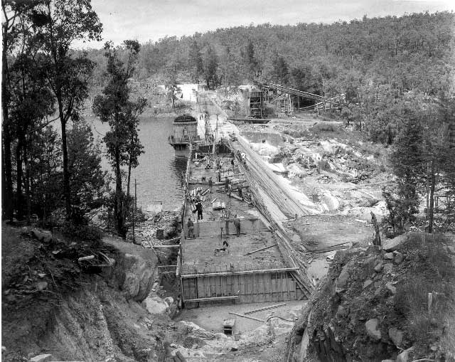
Mundaring Weir is a concrete gravity dam (and historically the adjoining locality) located from Perth, Western Australia in the Darling Scarp. The dam and reservoir form the boundary between the suburbs of Reservoir and Sawyers Valley. The dam impounds the Helena River. History A soldier, Ensign Robert Dale, became the first European to explore the region in 1829. European populations did not grow significantly until construction of the dam in the late 1890s. This involved the building of a Mundaring Weir railway line from Mundaring to the Mundaring Weir site. The Irish Australian engineer C. Y. O'Connor was involved in the design of a scheme that transported water to the Eastern Goldfields of Coolgardie and Kalgoorlie in the eastern part of Western Australia. The weir was completed in 1903. The lake created by the dam was known as the Helena River Reservoir, it was renamed as Lake C.Y. O'Connor in 2004. The owner of the dam, the Water Corporation, refers to th ... [...More Info...] [...Related Items...] OR: [Wikipedia] [Google] [Baidu] |
Goldfields Water Supply Scheme
The Goldfields Water Supply Scheme is a pipeline and dam project that delivers drinking water, potable water from Mundaring Weir in Perth to communities in Western Australia's Eastern Goldfields, particularly Coolgardie, Western Australia, Coolgardie and Kalgoorlie. The project was commissioned in 1896 and completed in 1903. The pipeline continues to operate today, supplying water to over 100,000 people in over 33,000 households as well as mines, farms and other enterprises. Water scarcity During the early 1890s, thousands of settlers had travelled into the barren and dry desert centre of Western Australia seeking gold, but the existing infrastructure for the supply of water was non-existent, and an urgent need arose. Prior to the scheme, water condensers, irregular rain, and Burlong Pool, Western Australia, water trains were part of the range of sources. Railway dams were essential for water to supply locomotives to travel to the goldfields. Origins of the scheme Throughout ... [...More Info...] [...Related Items...] OR: [Wikipedia] [Google] [Baidu] |
State Register Of Heritage Places
The State Register of Heritage Places is the heritage register of historic sites in Western Australia deemed significant at the state level by the Heritage Council of Western Australia. History In the 1970s, following its establishment of the National Trust of Western Australia, the National Trust created a set of classified properties, and following legislation requiring inventories, Local Government authorities in Western Australia produced a subsequent set of Municipal Inventories, which then resulted in items then being included in the state register. As a result, most register records include dates and details from the three different processes. In some cases authorities other than councils had governance over localities such as ''Redevelopment'' authorities, and they also provided Heritage Inventories in that stage of the process. Registration was not always a successful protection. The Mitchells Building on Wellington Street was state heritage listed in 2004 but demoli ... [...More Info...] [...Related Items...] OR: [Wikipedia] [Google] [Baidu] |
Walgoolan, Western Australia
Walgoolan is a small town located in the eastern Wheatbelt region of Western Australia. It is situated between Merredin and Bodallin along the Great Eastern Highway. Originating as a railway siding on the main eastern railway, Walgoolan was established between 1895 and 1899. Land was set aside for a townsite in 1913 and lots were surveyed in 1922. The townsite was gazetted in 1923. The name of the town is Aboriginal in origin and means ''place where the short bushes grow''. Following World War I, nearly 100 settlers took up land in the area, which were cleared and planted with cereal crops, mostly wheat. The town was a thriving community with five schools, tennis courts, a cricket club, Country Women's Association and Wheat Growers Union. Tenders for the construction of a brick and cement hall in the town were called for in 1926. The hall was opened and being used for recitals and other community events the following year. The Westonia Road board held a referendum among ... [...More Info...] [...Related Items...] OR: [Wikipedia] [Google] [Baidu] |


