|
Omanawa Caldera
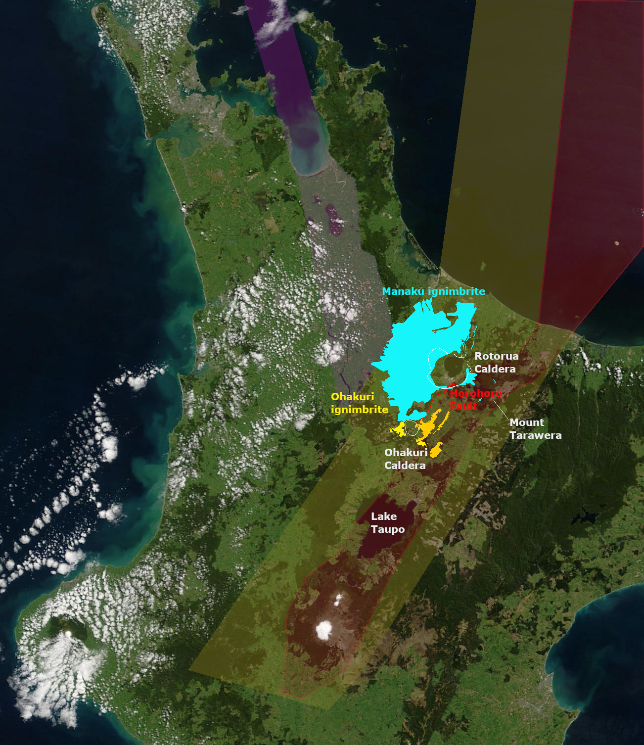
Omanawa Caldera is inferred by an area of magnetic anomaly that exists to the north-west of the Rotorua Caldera. It is also located to the north west of the present boundary of the modern Taupō Volcanic Zone but its existence would be compatible with activity in the area of intersection of Taupo Rift and Hauraki Rift before 1.9 million years ago. The area of the caldera is covered by Mamaku Ignambrite from the Mamaku eruption of 240,000 years ago that formed the Rotorua Caldera. Eruptions from the Omanawa Caldera would explain formations such as the Waiteariki ignimbrite which covers much of the Bay of Plenty and forms the bulk of the Whakamarama Plateau. This would date the major caldera formation to 2.1 million years ago. However, there are at least eight large eruptions that occurred in the Tauranga Volcanic Centre The Tauranga Volcanic Centre is a geologic region in New Zealand's Bay of Plenty. It extends from the southern end of Waihi Beach and from the old volcanoes o ... [...More Info...] [...Related Items...] OR: [Wikipedia] [Google] [Baidu] |
Taupō Volcanic Zone
The Taupō Volcanic Zone (TVZ) is a volcanic area in the North Island of New Zealand that has been active for the past two million years and is still highly active. Mount Ruapehu marks its south-western end and the zone runs north-eastward through the Taupō and Rotorua areas and offshore into the Bay of Plenty. It is part of the larger Central Volcanic Region that extends further westward through the western Bay of Plenty to the eastern side of the Coromandel Peninsula and has been active for four million years. At Taupō the rift volcanic zone is widening east–west at the rate of about 8 mm per year while at Mount Ruapehu it is only 2–4 mm per year but this increases at the north eastern end at the Bay of Plenty coast to 10–15 mm per year. It is named after Lake Taupō, the flooded caldera of the largest volcano in the zone, the Taupō Volcano and contains a large central volcanic plateau as well as other landforms associated with its containing tecton ... [...More Info...] [...Related Items...] OR: [Wikipedia] [Google] [Baidu] |
North Island
The North Island, also officially named Te Ika-a-Māui, is one of the two main islands of New Zealand, separated from the larger but much less populous South Island by the Cook Strait. The island's area is , making it the world's 14th-largest island. The world's 28th-most-populous island, Te Ika-a-Māui has a population of accounting for approximately % of the total residents of New Zealand. Twelve main urban areas (half of them officially cities) are in the North Island. From north to south, they are Whangārei, Auckland, Hamilton, Tauranga, Rotorua, Gisborne, New Plymouth, Napier, Hastings, Whanganui, Palmerston North, and New Zealand's capital city Wellington, which is located at the south-west tip of the island. Naming and usage Although the island has been known as the North Island for many years, in 2009 the New Zealand Geographic Board found that, along with the South Island, the North Island had no official name. After a public consultation, the board offi ... [...More Info...] [...Related Items...] OR: [Wikipedia] [Google] [Baidu] |
Caldera
A caldera ( ) is a large cauldron-like hollow that forms shortly after the emptying of a magma chamber in a volcano eruption. When large volumes of magma are erupted over a short time, structural support for the rock above the magma chamber is gone. The ground surface then collapses into the emptied or partially emptied magma chamber, leaving a large depression at the surface (from one to dozens of kilometers in diameter). Although sometimes described as a crater, the feature is actually a type of sinkhole, as it is formed through subsidence and collapse rather than an explosion or impact. Compared to the thousands of volcanic eruptions that occur each century, the formation of a caldera is a rare event, occurring only a few times per century. Only seven caldera-forming collapses are known to have occurred between 1911 and 2016. More recently, a caldera collapse occurred at Kīlauea, Hawaii in 2018. Etymology The term ''caldera'' comes from Spanish ', and Latin ', mean ... [...More Info...] [...Related Items...] OR: [Wikipedia] [Google] [Baidu] |
Magnetic Anomaly
In geophysics, a magnetic anomaly is a local variation in the Earth's magnetic field resulting from variations in the chemistry or magnetism of the rocks. Mapping of variation over an area is valuable in detecting structures obscured by overlying material. The magnetic variation ( geomagnetic reversals) in successive bands of ocean floor parallel with mid-ocean ridges was important evidence for seafloor spreading, a concept central to the theory of plate tectonics. Measurement Magnetic anomalies are generally a small fraction of the magnetic field. The total field ranges from 25,000 to 65,000 nanoteslas (nT). To measure anomalies, magnetometers need a sensitivity of 10 nT or less. There are three main types of magnetometer used to measure magnetic anomalies: # The fluxgate magnetometer was developed during World War II to detect submarines. It measures the component along a particular axis of the sensor, so it needs to be oriented. On land, it is often oriented vertically ... [...More Info...] [...Related Items...] OR: [Wikipedia] [Google] [Baidu] |
Rotorua Caldera
The Rotorua Caldera, now in filled with Lake Rotorua, is a large rhyolitic caldera. It is one of several large volcanoes located in the Taupō Volcanic Zone on the North Island of New Zealand. Geography The major regional settlement of Rotorua is located in the caldera. There is geothermal activity in the city of Rotorua and the geothermal areas of Tikitere and Whakarewarewa are associated with the caldera. These areas are still associated with small hydrothermal eruptions. Geology Eruption history The caldera was formed in a single event paired major eruption, that lasted only weeks, is now dated about 240,000 years ago, and which ejected more than of rhyolitic Mamaku ignimbrite giving it a Volcanic Explosivity Index of 7. The eruption has been reinterpreted as a paired eruption with a very slightly later, slightly smaller southerly eruption from the same mush body feeding the Ohakuri Caldera. Ignimbrite, up to thick covering about , was deposited in the surrounding area, ... [...More Info...] [...Related Items...] OR: [Wikipedia] [Google] [Baidu] |
Hauraki Rift
The Hauraki Rift is an active NeS-to NWeSE-striking rift valley system in the North Island of New Zealand that has produced the Firth of Thames and the Hauraki Plains. It is approximately wide and long. Geology The rift valley in the north appears to be delimited in the west by the line of the Firth of Thames Fault and to the east by the Hauraki Fault. The mountains of the Coromandel (which include andesitic and basaltic back arc volcanoes) and Kaimai Range to the east and the Hunua Range to the west give it the appearance of a full graben although it has also been described as a simple structure of 2 to 3 half-grabens so the term Hauraki Graben for the low lying portions would be incorrect. However the apparent line in the south of the Firth of Thames Fault no longer follows the apparent horst structure to the west and some believe the line of the Waikato River after it leaves the old Taupō Rift gives a better guide to the western line of the rift as structures have been ... [...More Info...] [...Related Items...] OR: [Wikipedia] [Google] [Baidu] |
Ignimbrite
Ignimbrite is a type of volcanic rock, consisting of hardened tuff. Ignimbrites form from the deposits of pyroclastic flows, which are a hot suspension of particles and gases flowing rapidly from a volcano, driven by being denser than the surrounding atmosphere. New Zealand geologist Patrick Marshall (1869-1950) coined the term ''ignimbrite'' from the Latin ''igni-'' ireand ''imbri-'' ain Ignimbrites are made of a very poorly sorted mixture of volcanic ash (or tuff when lithified) and pumice lapilli, commonly with scattered lithic fragments. The ash is composed of glass shards and crystal fragments. Ignimbrites may be loose and unconsolidated, or lithified (solidified) rock called lapilli-tuff. Near the volcanic source, ignimbrites often contain thick accumulations of lithic blocks, and distally, many show meter-thick accumulations of rounded cobbles of pumice. Ignimbrites may be white, grey, pink, beige, brown, or black depending on their composition and density. Many pale ... [...More Info...] [...Related Items...] OR: [Wikipedia] [Google] [Baidu] |
Bay Of Plenty
The Bay of Plenty ( mi, Te Moana-a-Toi) is a region of New Zealand, situated around a bight of the same name in the northern coast of the North Island. The bight stretches 260 km from the Coromandel Peninsula in the west to Cape Runaway in the east. The Bay of Plenty Region, governed by the Bay of Plenty Regional Council, incorporates several large islands in the bay, in addition to the mainland area. Called ''Te Moana-a-Toi'' (the Sea of Toi) in the Māori language after Toi, an early ancestor, the name 'Bay of Plenty' was bestowed by James Cook in 1769 when he noticed the abundant food supplies at several Māori villages there, in stark contrast to observations he had made earlier in Poverty Bay. History According to local Māori traditions, the Bay of Plenty was the landing point of several migration canoes that brought Māori settlers to New Zealand. These include the '' Mātaatua'', '' Nukutere'', '' Tākitimu'', '' Arawa'' and '' Tainui'' canoes. Many of ... [...More Info...] [...Related Items...] OR: [Wikipedia] [Google] [Baidu] |
Tauranga Volcanic Centre
The Tauranga Volcanic Centre is a geologic region in New Zealand's Bay of Plenty. It extends from the southern end of Waihi Beach and from the old volcanoes of the Coromandel Peninsula that make up the northern part of the Kaimai Range, towards the Taupō Volcanic Zone. It was the site, about 2.1 million years ago, of the large single eruption event of Waiteariki ignimbrite with DRE of . Geology The Tauranga Volcanic Centre is at the intersection of the Hauraki and Taupō Rifts and was active during a period of tectonic transition from 2.95 to 1.9 million years ago when major volcanism moved south in Zealandia from the Coromandel Volcanic Zone. It thus has importance geologically as a region of transition, previously classified as part of the Central Volcanic Region, which appears to have commenced as early as 4.5 million years ago from compositional analysis of sea floor eruptives. Part of it to the north west is sometimes defined separately in the literature as the Kaimai ... [...More Info...] [...Related Items...] OR: [Wikipedia] [Google] [Baidu] |
Rift Volcanoes
In geology, a rift is a linear zone where the lithosphere is being pulled apart and is an example of extensional tectonics. Typical rift features are a central linear downfaulted depression, called a graben, or more commonly a half-graben with normal faulting and rift-flank uplifts mainly on one side. Where rifts remain above sea level they form a rift valley, which may be filled by water forming a rift lake. The axis of the rift area may contain volcanic rocks, and active volcanism is a part of many, but not all, active rift systems. Major rifts occur along the central axis of most mid-ocean ridges, where new oceanic crust and lithosphere is created along a divergent boundary between two tectonic plates. ''Failed rifts'' are the result of continental rifting that failed to continue to the point of break-up. Typically the transition from rifting to spreading develops at a triple junction where three converging rifts meet over a hotspot. Two of these evolve to the point of ... [...More Info...] [...Related Items...] OR: [Wikipedia] [Google] [Baidu] |


