|
Nandail Upazila
Nandail () is an upazila of Mymensingh District in the division of Mymensingh Division, Mymensingh, Bangladesh, and is located roughly 46 kilometers from Mymensingh City. History During the rule of Alauddin Husain Shah, Muazzamabad (currently, Muazzampur) was the administrative headquarters of East Bengal. The British established ''Neel Kuthi'' (Indigo center) in the 18th century at the Razbari Bazaar of Nandail, and the indigo revolt started in the area. In 1971 Nandail suffered many losses. On 21 April, the Pakistan Army, Pakistan army killed 18 people and burned a few hundred houses in the Rajgati, Shuvokhila, and Kaliganj areas. On 17 November, a total of 27 freedom fighters including Illias Uddin Bhuiyan, Shamsul Haque, Zillul Baki, Thana Awami, and Shahnewaz Bhuiyan were killed in a battle with Pakistan. This day is now observed as the ''Nandail Shaheed Day''. Geography Nandail is located at . It has 87,523 households and a total area of 326.37 km2. It is bounded by I ... [...More Info...] [...Related Items...] OR: [Wikipedia] [Google] [Baidu] |
Upazilas Of Bangladesh
An ''upazila'' ( pronounced: ), formerly called ''thana'', is an administrative division in Bangladesh, functioning as a sub-unit of a districts of Bangladesh, district. It can be seen as an analogous to a county or a borough of Western countries. Rural upazilas are further administratively divided into Union councils of Bangladesh, union council areas (union parishads). Bangladesh has 495 upazilas. The upazilas are the second lowest tier of regional administration in Bangladesh. The administrative structure consists of divisions (8), districts (64), upazilas (495) and union parishads (UPs). This system of devolution was introduced by the former military ruler and president of Bangladesh, Hossain Mohammad Ershad, Lt-Gen Hossain Muhammad Ershad, in an attempt to strengthen local government. Below UPs, villages (''gram'') and ''para'' exist, but these have no administrative power and elected members. The Local Government local ordinance, Ordinance of 1982 was amended a year lat ... [...More Info...] [...Related Items...] OR: [Wikipedia] [Google] [Baidu] |
Kendua Upazila
Kendua () is an upazila of Netrokona District in the Division of Mymensingh, Bangladesh. Geography Kendua is located at . It has 66133 households and total area . The upazila is bounded by Netrokona Sadar and Atpara upazilas on the north, Tarail Upazila of Kishoreganj district on the south, Madan upazila on the east, Ishwarganj, Gauripur and Nandail upazilas on the west. Demographics According to the 2011 Census of Bangladesh, Kendua Upazila had 66,133 households and a population of 304,729. 87,575 (28.74%) were under 10 years of age. Kendua has a literacy rate (age 7 and over) of 37.58%, compared to the national average of 51.8%, and a sex ratio of 1031 females per 1000 males. 22,363 (7.34%) lived in urban areas. As of the 1991 Bangladesh census, Kendua had a population of 265628. Males constituted 50.58% of the population, and females 49.42%. This Upazila's eighteen up population was 133969. Kendua had an average literacy rate of 37.1% (7+ years), and the national aver ... [...More Info...] [...Related Items...] OR: [Wikipedia] [Google] [Baidu] |
Mahalla
is an Arabic word variously translated as district, Quarter (country subdivision), quarter, Ward (country subdivision), ward, or neighborhood in many parts of the Arab world, the Balkans, Western Asia, the Indian subcontinent, and nearby nations. History Historically, mahallas were autonomous social institutions built around familial ties and Islamic rituals. Today it is popularly recognised also by non-Muslims as a neighbourhood in large cities and towns. Mahallas lie at the intersection of private family life and the public sphere. Important community-level management functions are performed through mahalle solidarity, such as religious ceremonies, life-cycle rituals, resource management and conflict resolution. It is an official administrative unit in many Middle Eastern countries. The word was brought to the Balkans through Ottoman Turkish language, Ottoman Turkish ''mahalle'', but it originates in Arabic محلة (''mähallä''), from the root meaning "to settle", "to occupy". ... [...More Info...] [...Related Items...] OR: [Wikipedia] [Google] [Baidu] |
Achargaon Union
Achargaon is a union of Nandail Upazila, Mymensingh District, Bangladesh Bangladesh, officially the People's Republic of Bangladesh, is a country in South Asia. It is the List of countries and dependencies by population, eighth-most populous country in the world and among the List of countries and dependencies by .... It is located on the bank on Narasundhar river on area about . About 27,000 people are living here. References Populated places in Mymensingh District {{Mymensingh-geo-stub ... [...More Info...] [...Related Items...] OR: [Wikipedia] [Google] [Baidu] |
Union Parishad
Union council (), also known as union parishad, rural council, rural union and simply union, is the smallest rural administrative and local government unit in Bangladesh, with zila parishads (district councils) being the largest rural authorities and upazila parishads (sub-district council) being the intermediate level. A union council, headed by a chairperson, consists of nine wards. These wards serve the purpose of electing members for general seats, with three additional seats reserved for women, all of which are directly elected. Union councils are formed under the ''Local Government (Union Parishads) Act, 2009''. The boundary of each union council is demarcated by the deputy commissioner of the district. Union councils are responsible for various development tasks, including agriculture, education, health, infrastructure, and sanitation. They also oversee administrative duties like birth registration, census activities, and maintaining civil status registers. Addition ... [...More Info...] [...Related Items...] OR: [Wikipedia] [Google] [Baidu] |
Agricultural Land
Agricultural land is typically land ''devoted to'' agriculture, the systematic and controlled use of other organism, forms of lifeparticularly the rearing of livestock and production of cropsto produce food for humans. It is generally synonymous with both farmland or cropland, as well as pasture or rangeland. The United Nations Food and Agriculture Organization (FAO) and others following its definitions, however, also use ''agricultural land'' or as a term of art, where it means the collection of: * ''arable land'' (also known as ''cropland''): here redefined to refer to land producing crops requiring annual replanting or fallowland or pasture used for such crops within any five-year period * ''permanent cropland'': land producing crops which do not require annual replanting * ''permanent pastures'': natural or artificial grasslands and shrublands able to be used for grazing livestock This sense of "agricultural land" thus includes a great deal of land not devoted to agricultura ... [...More Info...] [...Related Items...] OR: [Wikipedia] [Google] [Baidu] |
1991 Bangladesh Census
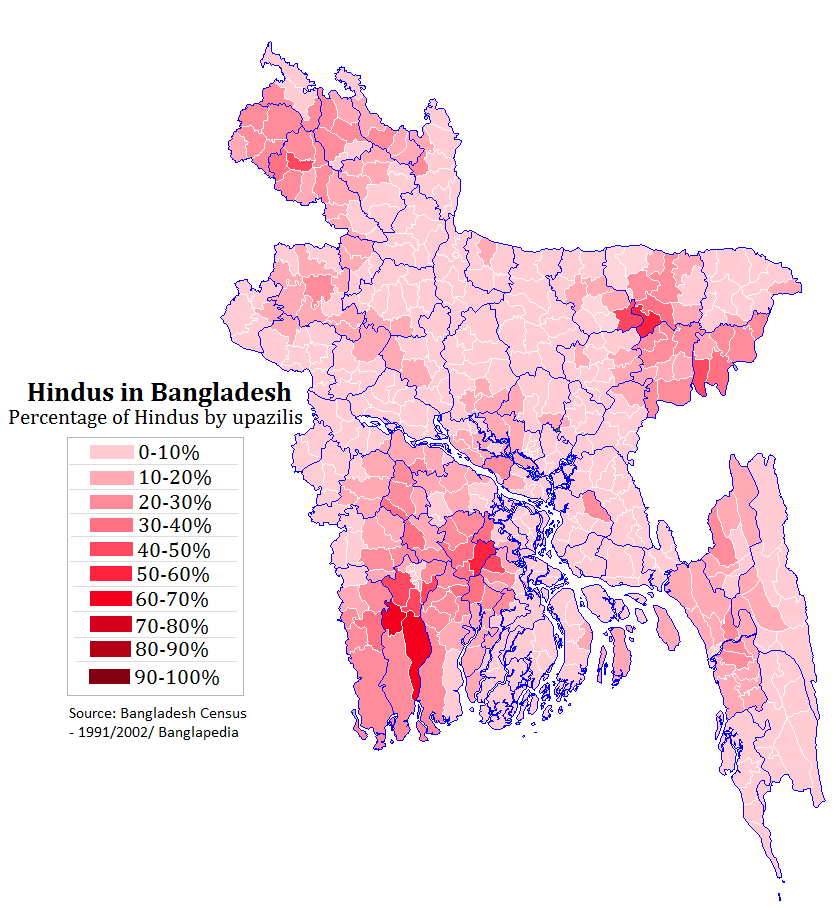
In 1991, the Bangladesh Bureau of Statistics, conducted a national census in Bangladesh. They recorded data from all of the districts and upazilas and main cities in Bangladesh including statistical data on population size, households, sex and age distribution, marital status, economically active population, literacy and educational attainment, religion, number of children etc. According to the census, Hindus were 10.5 per cent of the population, down from 12.1 per cent as of 1981. Bangladesh have a population of 106,314,992 as per the 1991 national census report. As many as 93,886,769 reported that they were Muslims, 11,184,337 reported as Hindus, 616,626 as Buddhists, 350,839 as Christians and 276,418 as others. See also * Demographics of Bangladesh * 2001 Census of Bangladesh * 2011 Census of Bangladesh * 2022 Census of Bangladesh References External links * Bangladesh Bureau of Statistics"Census Reports: Population Census-2001" 2001. The 1991 census figures can be ... [...More Info...] [...Related Items...] OR: [Wikipedia] [Google] [Baidu] |
2011 Bangladesh Census
In 2011, the Bangladesh Bureau of Statistics conducted a national census in Bangladesh, which provided a provisional estimate of the total population of the country as 142,319,000. The previous decennial census was the 2001 census. Data were recorded from all of the districts and upazilas and main cities in Bangladesh, including statistical data on population size, households, sex and age distribution, marital status, economically active population, literacy and educational attainment, religion, number of children etc. Bangladesh and India also conducted their first joint census of areas along their border in 2011. According to the census, Hindus constituted 8.5 per cent of the population as of 2011, down from 9.6 per cent in the 2001 census. Bangladesh has a population of 144,043,697 as per the 2011 census report. The majority of 130,201,097 reported that they were Muslim, 12,301,331 reported as Hindu, 864,262 as Buddhist, 532,961 as Christian and 201,661 as others. See als ... [...More Info...] [...Related Items...] OR: [Wikipedia] [Google] [Baidu] |
Hinduism In Bangladesh
Hinduism is the second largest religion in Bangladesh, as according to the 2022 Census of Bangladesh, approximately 13.1 million people responded as Hindus, constituting 7.95% of the nation. Bangladesh is the third-largest Hindu populated country in the world, after India and Nepal. Hinduism is the Religion in Bangladesh, second-largest religion in 61 of 64 districts in Bangladesh, but there are no Hindu majority districts in Bangladesh. Demographics According to the 2001 Bangladesh census, there were around 11.82 million Hindus in Bangladesh constituting 9.6% of the population, which at the time was 123.15 million. The 2011 Bangladesh census, Bangladesh 2011 census states, that approximately 12.73 million people responded that they were Hindus, constituting 8.54% of the total 149.77 million. While 2022 Census of Bangladesh, put the number of Hindus in Bangladesh at 13.1 million out of total 165.1 million population, thus constituting 7.95% of the population. According to ... [...More Info...] [...Related Items...] OR: [Wikipedia] [Google] [Baidu] |
Islam In Bangladesh
Islam is the largest and the state religion of the People's Republic of Bangladesh. According to the 2022 census, Bangladesh had a population of about 150 million Muslims, or 91.04% of its total population of million. Muslims of Bangladesh are predominant native Bengali Muslims. The majority of Bangladeshis are ''Sunni'', and follow the '' Hanafi'' school of ''Fiqh''. Bangladesh is a ''de facto'' secular country. The Bengal region was a supreme power of the medieval Islamic East. In the late 7th century, Muslims from Arabia established commercial as well as religious connection within the Bengal region before the conquest, mainly through the coastal regions as traders and primarily via the ports of Chittagong. In the early 13th century, Muhammad bin Bakhtiyar Khalji conquered Western and part of Northern Bengal and established the first Muslim kingdom in Bengal. During the 13th century, Sufi missionaries, mystics and saints began to preach Islam in villages. The Islamic ... [...More Info...] [...Related Items...] OR: [Wikipedia] [Google] [Baidu] |
Narsunda River
Narsunda is a river located at Kishoreganj District in Bangladesh. Narsunda River is created from Brahmaputra River at Hossainpur Upazila. After the creation of the river, its course take it through Jangalia Union, Pakundia Upazila and through Kishoreganj town and beside Govt. Gurudayal College. Famous writer Nirad C. Chaudhuri mentioned this river in his autobiography, ''The Autobiography of an Unknown Indian ''The Autobiography of an Unknown Indian'' is the 1951 autobiography of Indian writer Nirad C. Chaudhuri. Written when he was around 50, it records his life from his birth in 1897 in Kishoreganj, a small town in present-day Bangladesh. The book ...''. Length of this river is around 60 km. References {{coord, 24, 27, 44, N, 90, 57, 56, E, display=title, region:BD_type:river Rivers of Bangladesh Rivers of Dhaka Division ... [...More Info...] [...Related Items...] OR: [Wikipedia] [Google] [Baidu] |
Old Brahmaputra River
The Old Brahmaputra River () is a distributary of the Brahmaputra River in north-central Bangladesh. Historically it constituted the main stem of the Brahmaputra, however, the larger river's primary outflow was redirected via the Jamuna River after the 1762 Arakan earthquake. Today, the Old Brahmaputra has been relegated to a minor river with much less flow than its former self. The river branches off from the Brahmaputra in Jamalpur District and Mymensingh then flows southeasterly for approximately before meeting the Meghna River in Kishoreganj District Kishoreganj District () is a district in Dhaka Division, Bangladesh. Earlier it was a ''mahakuma'' (sub-division) under Mymensingh District, Mymensingh district. 2495.07 km2 of land was taken from Mymensingh District, Mymensingh district to fo .... References Rivers of Bangladesh Rivers of Mymensingh Division Rivers of Dhaka Division {{Mymensingh-geo-stub ... [...More Info...] [...Related Items...] OR: [Wikipedia] [Google] [Baidu] |


