|
Matsumoto Pond
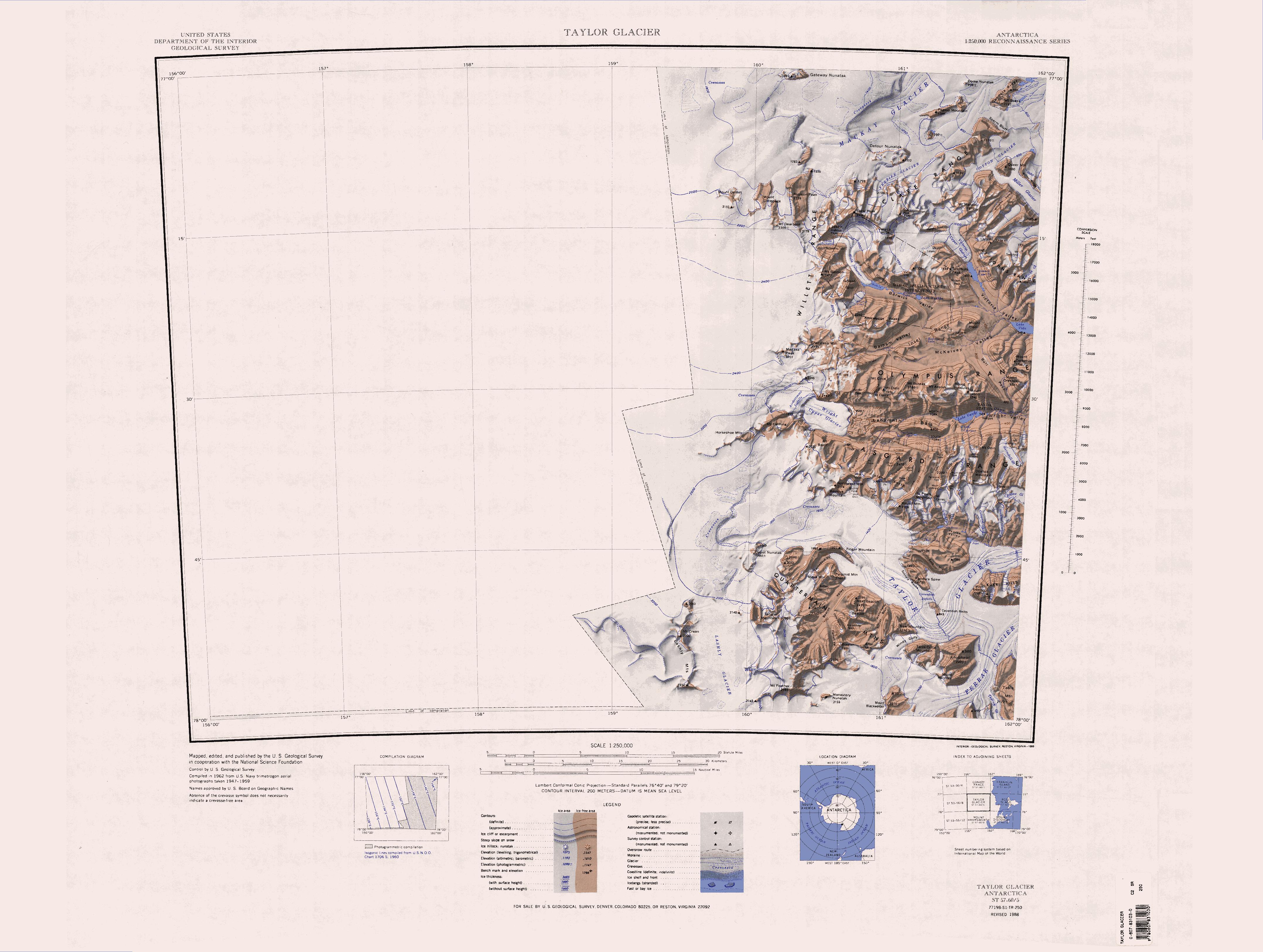
Matsumoto Pond () is a pond south of Dais Col and west of Don Juan Pond in South Fork, Wright Valley, Victoria Land, Antarctica. It was named by the Advisory Committee on Antarctic Names (1997) after Japanese chemist Genki I. Matsumoto, who was a member of four Japanese Antarctic Research Expedition field parties (1976–77, 1981–82, 1983–84, 1985–86) that made geophysical and geochemical studies of ponds in the McMurdo Dry Valleys The McMurdo Dry Valleys are a row of largely Antarctic oasis, snow-free valleys in Antarctica, located within Victoria Land west of McMurdo Sound. The Dry Valleys experience extremely low humidity and surrounding mountains prevent the flow of ..., including investigation of this feature. References Lakes of Victoria Land McMurdo Dry Valleys {{McMurdoDryValleys-geo-stub ... [...More Info...] [...Related Items...] OR: [Wikipedia] [Google] [Baidu] |
Dais Col
The Wright Valley () is a large east–west trending valley, formerly occupied by a glacier but now ice free except for Wright Upper Glacier at its head and Wright Lower Glacier at its mouth, in Victoria Land, Antarctica. It was named by the VUWAE (1958-59) for C. S. WSir Charles Wright, for whom the BrAE (1910-13) named the glacier at the mouth of this valley. The Wright Valley is the central one of the three large McMurdo Dry Valleys in the Transantarctic Mountains, located west of McMurdo Sound. Wright Valley contains the Onyx River, the longest river in Antarctica, Lake Brownworth, the origin of the Onyx River, and Lake Vanda, which is fed by the Onyx River. Its southwestern branch, ''South Fork'', is the location of Don Juan Pond. The upland area known as the Labyrinth (Antarctica), Labyrinth is at the valley's west end. Exploration Although portions of the interconnected valley system were discovered in 1903 by the Discovery Expedition, ''Discovery'' expedition led by ... [...More Info...] [...Related Items...] OR: [Wikipedia] [Google] [Baidu] |
Don Juan Pond
Don Juan Pond is a small and very shallow hypersaline lake in the western end of Wright Valley (South Fork), Victoria Land, Antarctica, west from Lake Vanda. It is wedged between the Asgard Range to the south and the Dais Range to the north. On the west end is a small tributary and a rock glacier. With a salinity level of 45.8%, Don Juan Pond is the saltiest of the Antarctic lakes. This salinity causes significant freezing-point depression, allowing the pond to remain liquid even at temperatures as low as . Don Juan Pond was discovered in 1961. It was named for two helicopter pilots, Lt. Don Roe and Lt. John Hickey, who piloted the helicopter involved with the first field party investigating the pond. Salinity Don Juan Pond is a shallow, flat-bottom, hyper-saline pond. It has the second-highest total dissolved solids on record, 1.3 times greater salinity than the Dead Sea. Salinity varies over time from 200 to 474 g/L, dominated by calcium chloride. It is the only Antarcti ... [...More Info...] [...Related Items...] OR: [Wikipedia] [Google] [Baidu] |
South Fork (Antarctica)
The Wright Valley () is a large east–west trending valley, formerly occupied by a glacier but now ice free except for Wright Upper Glacier at its head and Wright Lower Glacier at its mouth, in Victoria Land, Antarctica. It was named by the VUWAE (1958-59) for Sir Charles Wright, for whom the BrAE (1910-13) named the glacier at the mouth of this valley. The Wright Valley is the central one of the three large McMurdo Dry Valleys in the Transantarctic Mountains, located west of McMurdo Sound. Wright Valley contains the Onyx River, the longest river in Antarctica, Lake Brownworth, the origin of the Onyx River, and Lake Vanda, which is fed by the Onyx River. Its southwestern branch, ''South Fork'', is the location of Don Juan Pond. The upland area known as the Labyrinth is at the valley's west end. Exploration Although portions of the interconnected valley system were discovered in 1903 by the ''Discovery'' expedition led by Captain Robert Falcon Scott, the Wright Valley lo ... [...More Info...] [...Related Items...] OR: [Wikipedia] [Google] [Baidu] |
Wright Valley
The Wright Valley () is a large east–west trending valley, formerly occupied by a glacier but now ice free except for Wright Upper Glacier at its head and Wright Lower Glacier at its mouth, in Victoria Land, Antarctica. It was named by the VUWAE (1958-59) for Sir Charles Wright, for whom the BrAE (1910-13) named the glacier at the mouth of this valley. The Wright Valley is the central one of the three large McMurdo Dry Valleys in the Transantarctic Mountains, located west of McMurdo Sound. Wright Valley contains the Onyx River, the longest river in Antarctica, Lake Brownworth, the origin of the Onyx River, and Lake Vanda, which is fed by the Onyx River. Its southwestern branch, ''South Fork'', is the location of Don Juan Pond. The upland area known as the Labyrinth is at the valley's west end. Exploration Although portions of the interconnected valley system were discovered in 1903 by the ''Discovery'' expedition led by Captain Robert Falcon Scott, the Wright Valle ... [...More Info...] [...Related Items...] OR: [Wikipedia] [Google] [Baidu] |
Victoria Land
Victoria Land is a region in eastern Antarctica which fronts the western side of the Ross Sea and the Ross Ice Shelf, extending southward from about 70°30'S to 78th parallel south, 78°00'S, and westward from the Ross Sea to the edge of the Antarctic Plateau. It was discovered by Captain James Clark Ross in January 1841 and named after Victoria of the United Kingdom, Queen Victoria. The rocky promontory of Minna Bluff is often regarded as the southernmost point of Victoria Land, and separates the Scott Coast to the north from the Hillary Coast of the Ross Dependency to the south. History Early explorers of Victoria Land include James Clark Ross and Douglas Mawson. In 1979, scientists discovered a group of 309 Meteorite, meteorites in Antarctica, some of which were found near the Allan Hills in Victoria Land. The meteorites appeared to have undergone little change since they were formed at what scientists believe was the birth of the Solar System. In 1981, Lichen, lichens fo ... [...More Info...] [...Related Items...] OR: [Wikipedia] [Google] [Baidu] |
Advisory Committee On Antarctic Names
The Advisory Committee on Antarctic Names (ACAN or US-ACAN) is an advisory committee of the United States Board on Geographic Names responsible for recommending commemorative names for features in Antarctica. History The committee was established in 1943 as the Special Committee on Antarctic Names (SCAN). It became the Advisory Committee on Antarctic Names in 1947. Fred G. Alberts was Secretary of the Committee from 1949 to 1980. By 1959, a structured nomenclature was reached, allowing for further exploration, structured mapping of the region and a unique naming system. A 1990 ACAN gazeeter of Antarctica listed 16,000 names. Description The United States does not recognise territorial boundaries within Antarctica, so ACAN assigns names to features anywhere within the continent, in consultation with other national nomenclature bodies where appropriate, as defined by the Antarctic Treaty System. The research and staff support for the ACAN is provided by the United States Geologi ... [...More Info...] [...Related Items...] OR: [Wikipedia] [Google] [Baidu] |
Genki I
Genki may refer to: *Genki (company), a Japanese video game company *Genki (era), a Japanese era name *Genki (given name) Genki (written: 元気, 元喜, 元基, 元規, 源気 or 源基) is a masculine Japanese given name. Notable people with the name include: *, Japanese lawyer, bureaucrat and politician *, Japanese sumo wrestler * Genki Dean (born 1991), Japanese ..., a masculine Japanese given name *'' Genki: An Integrated Course in Elementary Japanese'', a Japanese language textbook {{disambiguation ... [...More Info...] [...Related Items...] OR: [Wikipedia] [Google] [Baidu] |
Japanese Antarctic Research Expedition
The refers to a series of Japanese Antarctic expeditions for scientific research. The first JARE expedition was launched in 1957 to coordinate with the International Geophysical Year. This was the team which left 15 dogs, including Taro and Jiro, behind after an emergency evacuation in February 1958. Expeditions to the Antarctic took place from 1968 to 1977, and ice cores were drilled on these expeditions, mostly at Mizuho Station (Antarctica), Mizuho. A later instance was an ecological expedition studying the ecosystems near Showa Station (Antarctica), Showa Station in Antarctica. The project was first undertaken in February 1986. It was associated with the international BIOTAS program, which also launched in 1986. Taxonomy (biology), Taxonomical studies of some organisms (particularly plants and small animals) were carried out by the expedition. The current research expedition is and began in November 2018 as part of the "Japanese Antarctic Research Project Phase IX". Re ... [...More Info...] [...Related Items...] OR: [Wikipedia] [Google] [Baidu] |
McMurdo Dry Valleys
The McMurdo Dry Valleys are a row of largely Antarctic oasis, snow-free valleys in Antarctica, located within Victoria Land west of McMurdo Sound. The Dry Valleys experience extremely low humidity and surrounding mountains prevent the flow of ice from nearby glaciers. The rocks there are granites and gneisses, and glacial tills dot this bedrock landscape, with loose gravel covering the ground. It is one of the driest places on Earth, though there are several anecdotal accounts of rainfall within the Dry Valleys. The region is one of the world's most extreme deserts, and includes many features including Lake Vida, a saline lake, and the Onyx River, a meltwater stream and Antarctica's longest river. Although no living organisms have been found in the permafrost here, Endolithic lichen, endolithic Photosynthesis, photosynthetic bacteria have been found living in the relatively moist interior of rocks, and anaerobic bacteria, with a metabolism based on iron and sulfur, live under ... [...More Info...] [...Related Items...] OR: [Wikipedia] [Google] [Baidu] |
Lakes Of Victoria Land
A lake is often a naturally occurring, relatively large and fixed body of water on or near the Earth's surface. It is localized in a basin or interconnected basins surrounded by dry land. Lakes lie completely on land and are separate from the ocean, although they may be connected with the ocean by rivers. Lakes, as with other bodies of water, are part of the water cycle, the processes by which water moves around the Earth. Most lakes are fresh water and account for almost all the world's surface freshwater, but some are salt lakes with salinities even higher than that of seawater. Lakes vary significantly in surface area and volume of water. Lakes are typically larger and deeper than ponds, which are also water-filled basins on land, although there are no official definitions or scientific criteria distinguishing the two. Lakes are also distinct from lagoons, which are generally shallow tidal pools dammed by sandbars or other material at coastal regions of oceans or large ... [...More Info...] [...Related Items...] OR: [Wikipedia] [Google] [Baidu] |


