|
Marsimik La
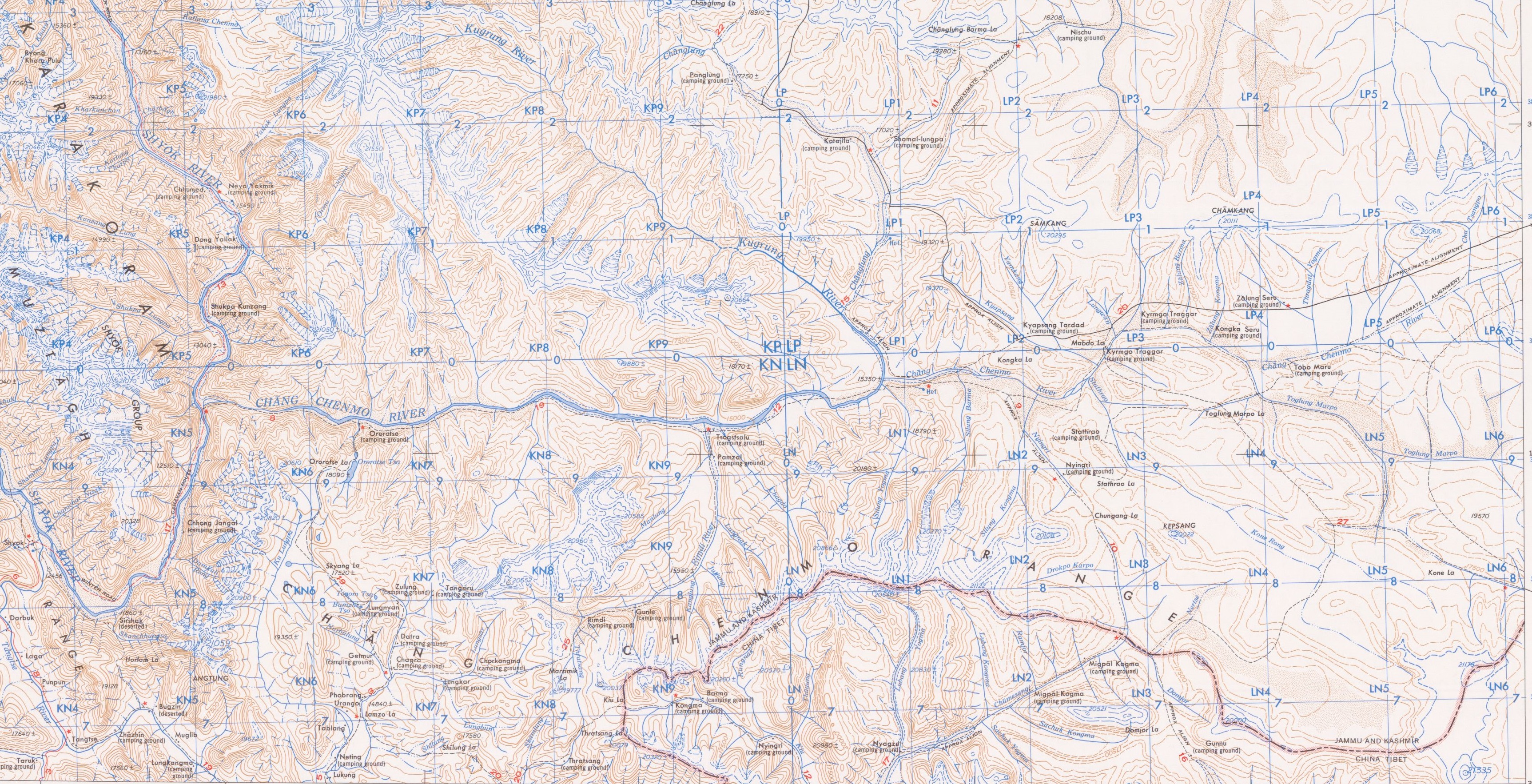
Marsimik La or Marsemik La, also called Lankar La, elevation is a high mountain pass in the Chang Chenmo Range in the Indian union territory of Ladakh, east of Leh as the crow flies. Ladakh's route to the Chang Chenmo Valley traverses the pass. Geography Marsimik La is located about northeast of Lukung at the tip of Pangong Lake, and southwest of Pamzal in the Chang Chenmo Valley. The ridge line of Marsimik La divides the basin of the Pangong Lake from the Chang Chenmo River. The description of Marsimik La in the ''Gazetteer of Kashmir and Ladak'' (1890) states:About 4 km to the east of Marsimik La is another ridge line which divides the western portion of the Pangong Lake basin with the central portion that drains into the lake via the Khurnak Plain. China's claimed border and the present Line of Actual Control runs through this ridge line. The passes Kiu La () and Ane La () lie on this ridge line. The river Kiu Chu flows down from Kiu La and joins Chume ... [...More Info...] [...Related Items...] OR: [Wikipedia] [Google] [Baidu] |
Ladakh
Ladakh () is a region administered by India as a union territory and constitutes an eastern portion of the larger Kashmir region that has been the subject of a Kashmir#Kashmir dispute, dispute between India and Pakistan since 1947 and India and China since 1959.The application of the term "administered" to the various regions of Kashmir and a mention of the Kashmir dispute is supported by the WP:TERTIARY, tertiary sources (a) through (e), reflecting WP:DUE, due weight in the coverage. Although "controlled" and "held" are also applied neutrally to the names of the disputants or to the regions administered by them, as evidenced in sources (h) through (i) below, "held" is also considered politicised usage, as is the term "occupied", (see (j) below). (a) (subscription required) Quote: "Kashmir, region of the northwestern Indian subcontinent ... has been the subject of dispute between India and Pakistan since the partition of the Indian subcontinent in 1947. The northern and wester ... [...More Info...] [...Related Items...] OR: [Wikipedia] [Google] [Baidu] |
Chumesang
Nyagzu or Nagzug () KNAB Place Name Database, retrieved 18 May 2022. is a pasture and campground in the Chumesang river valley to the north of Pangong Lake. It is in Sino-Indian border dispute, territory disputed between India and China, that has been under Chinese administration since 1960–1961. Nyagzu lies at the location where the Ruang Yogma stream debauches into the Chumesang river valley, and has been known to have ample vegetation amidst a barren landscape. Multiple sources during the British Raj, British colonial administration mentioned Nyagzu and the Ruang Yogma stream being the border between Ladakh and Tibet in this region. The Chinese claim line in 1956 can also be seen to follow this border. However, by 1960, China enlarged its claims much f ... [...More Info...] [...Related Items...] OR: [Wikipedia] [Google] [Baidu] |
Tsogtsalu
__NOTOC__ Tsogtsalu or Tsolu is a pasture and campsite in the Ladakh union territory of India, in the Chang Chenmo Valley close India's border with China. It is located at the confluence of the Rimdi Chu river that flows down from Marsemik La and the Chang Chenmo River. During the British Raj, this was a halting spot for travellers to Central Asia via the 'Chang Chenmo route', passing through Aksai Chin. After Indian independence, a border outpost was established here by a border police party headed by Captain Karam Singh. It continues to serve as a base for India's border forces. Within India, it is reachable by two motorable roads, the " Phobrang-Marsimik La-Tsogtsalu-Hot Springs Road" (PMTHR) or "Marsimik La Road" via Phobrang-Marsimik La-Tsogstsalu to Hot Springs, [...More Info...] [...Related Items...] OR: [Wikipedia] [Google] [Baidu] |
Shyok River
The Shyok River (sometimes spelled Shayok) is a major tributary of the Indus River that flows through northern Ladakh in India and into Gilgit-Baltistan in Pakistan. Originating from the Central Rimo Glacier in the eastern Karakoram, it runs for about before joining the Indus near Skardu. Its major tributaries include the Chip Chap River, Chip Chap, Galwan River, Galwan, Chang Chenmo River, Chang Chenmo, Nubra River, Nubra, and Hushe River, Hushe Rivers. Etymology The name ''Shyok'' is most likely derived from the Tibetan ''Sha-gyog'' (ཤ་གཡོག་), a compound of ''shag'' (ཤག་), meaning "gravel", and ''gyog'' (གཡོག་), meaning "to spread". This interpretation—translating to "gravel spreader"—is supported by linguistic sources and reflects the river's geomorphological behavior, particularly the extensive deposits of gravel it leaves during flooding. The form ''Shayog'', a variant closely aligned with this Tibetan origin, may underlie the spelling ... [...More Info...] [...Related Items...] OR: [Wikipedia] [Google] [Baidu] |
Extreme Points Of Earth
This article lists extreme locations on Earth that hold geographical records or are otherwise known for their geophysical or meteorological superlatives. All of these locations are Earth-wide extremes; extremes of individual continents or countries are not listed. Latitude and longitude Northernmost * The northernmost point of land is the northern tip of Kaffeklubben Island, north of Greenland (), which lies slightly north of Cape Morris Jesup, Greenland (). Various shifting gravel bars lie farther north, the most famous being Oodaaq. There have been other islands more northern such as 83-42 and ATOW1996 but they have not been confirmed as permanent. Southernmost * The southernmost continental point of land outside Antarctica is in South America at Cape Froward, Magallanes Region, Chile (). * The southernmost point of (liquid) water is a bay on the Filchner–Ronne Ice Shelf along the coast of Antarctica (), about south of Berkner Island. ** The southernmost point ... [...More Info...] [...Related Items...] OR: [Wikipedia] [Google] [Baidu] |
Border Roads Organisation
The Border Roads Organisation (BRO) is a statutory body under the ownership of the Ministry of Defence of the Government of India. BRO develops and maintains road networks in India's border areas and friendly neighboring countries. This includes infrastructure operations in 19 states and three union territories (including Andaman and Nicobar Islands) and neighboring countries such as Afghanistan, Bhutan, Myanmar, Tajikistan and Sri Lanka. By 2022, BRO had constructed over of roads, over 450 permanent bridges with a total length of over length and 19 airfields in strategic locations. BRO is also tasked with maintaining these infrastructure including operations such as snow clearance.Annual Report 2014–2015. Border Roads Organisation. (Chapter 7)'. Ministry of Road Transport and Highways. Government of IndiaArchivedon 12 February 2021.Annual Report 2015–2016'. Ministry of Defence. Government of India. Accessed on 13 June 2021. Officers from the Border Roads Engineering Serv ... [...More Info...] [...Related Items...] OR: [Wikipedia] [Google] [Baidu] |
Hot Springs, Chang Chenmo Valley
__NOTOC__ Hot Springs (traditional name: Kyam) is a campsite and the location of an Indian border outpost in the Chang Chenmo River valley in Ladakh near the disputed border with China. It is so named because there is a hot spring at this location. The Line of Actual Control near Kongka Pass is only to the east. Name Historically, the name for the hot spring was ''Kyam'' (''Kiam'', ''Kayam''). The Chinese still refer to it by this name. Geography Geologist Frederic Drew states that the Chang Chenmo river flows on a barren gravel bed, with occasional alluvium, alluvial patches where vegetation is found. Hot Springs is one such location. In the vicinity are also other such patches, named Pamzal, Tsogtsalu (or ''Tsolu'') and Gogra, Ladakh, Gogra. They were historical halting places for travellers and trading caravans, with a supply of water, fuel and fodder. Nomadic Ladakhi graziers also used them for grazing cattle. A large tributary called Kugrang River, Kugrang joins t ... [...More Info...] [...Related Items...] OR: [Wikipedia] [Google] [Baidu] |
Tsogstsalu
__NOTOC__ Tsogtsalu or Tsolu is a pasture and campsite in the Ladakh union territory of India, in the Chang Chenmo Valley close India's border with China. It is located at the confluence of the Rimdi Chu river that flows down from Marsemik La and the Chang Chenmo River. During the British Raj, this was a halting spot for travellers to Central Asia via the 'Chang Chenmo route', passing through Aksai Chin. After Indian independence, a border outpost was established here by a border police party headed by Captain Karam Singh. It continues to serve as a base for India's border forces. Within India, it is reachable by two motorable roads, the " Phobrang-Marsimik La-Tsogtsalu-Hot Springs Road" (PMTHR) or "Marsimik La Road" via Phobrang-Marsimik La-Tsogstsalu to Hot Springs, [...More Info...] [...Related Items...] OR: [Wikipedia] [Google] [Baidu] |
Phobrang
Phobrang is a settlement in the Indian union territory of Ladakh. It is near Lukung on the way the Indo-China border at the Hot Springs. It is the last village of Ladakh in this direction, at an elevation of . Phobrang is in the Leh district, Durbuk tehsil. It is the headquarters of a Halqa Panchahat (village administration), which covers the entire Pangong Tso region of Ladakh till Man Pangong. Phobrang was apparently lightly populated in the 19th century, but, at present, there is a small residential area, along with numerous semi-nomadic camping grounds, grazing grounds and farmlands, situated in an alluvial plain watered by a river flowing from the north. There is a Green Himalayas project under way to convert Phobrang to an eco-tourism site. The 84 km-long Marsimik La Road from Lukung to Hot Springs A hot spring, hydrothermal spring, or geothermal spring is a Spring (hydrology), spring produced by the emergence of Geothermal activity, geothermally heated gr ... [...More Info...] [...Related Items...] OR: [Wikipedia] [Google] [Baidu] |
Changlung Lungpa
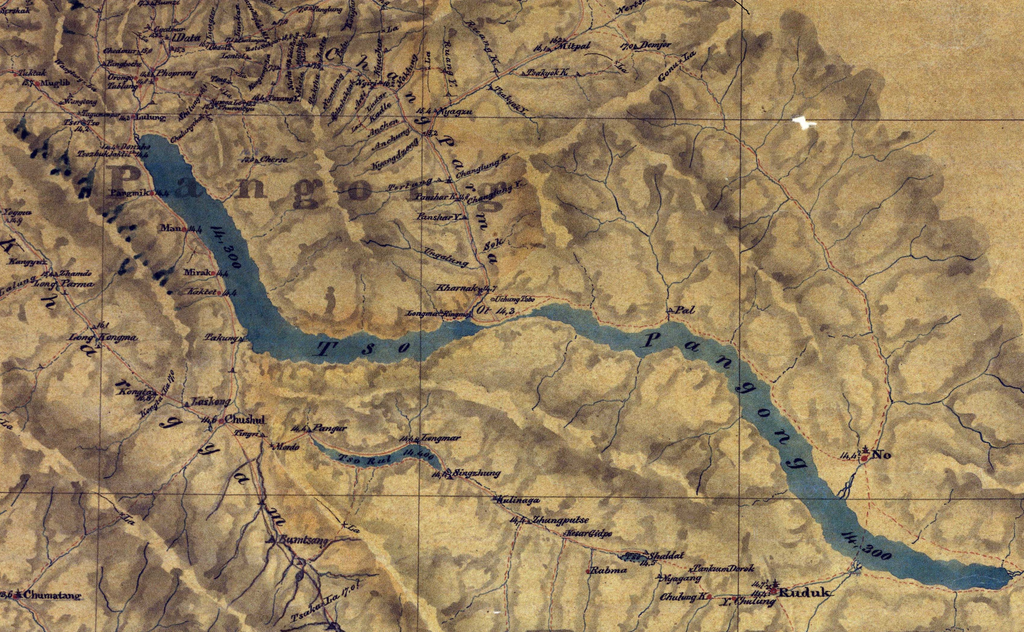
The Khurnak Fort () is a ruined fort on the northern shore of Pangong Lake, which spans eastern Ladakh in India and Rutog County in the Tibet region of China. The area of the Khurnak Fort is disputed by India and China, and has been under Chinese administration since 1958. Though the ruined fort itself is not of much significance, it serves as a landmark denoting the middle of Pangong Lake. The fort lies at the western edge of a large plain formed as the alluvial fan of a river called Changlung Lungpa, which falls into Pangong Lake from the north. The plain itself is called ''Ote Plain'' locally, but is now generally called the Khurnak Plain. Geography The Khurnak Fort stands on a large plain called ''Ot'' or ''Ote'' at the centre of Pangong Lake on its northern bank. In recent times, the plain has come to be called the "Khurnak Plain", after the fort. The plain divides Pangong Lake into two halves: to the west is the ''Pangong Tso'' proper and to the east are a string of ... [...More Info...] [...Related Items...] OR: [Wikipedia] [Google] [Baidu] |
Dambu Guru
Nyagzu or Nagzug () KNAB Place Name Database, retrieved 18 May 2022. is a pasture and campground in the Chumesang river valley to the north of . It is in territory disputed between India and China, that has been under Chinese administration since 1960–1961. Nyagzu lies at the location where the Ruang Yogma stream debauches into the Chumesang river valley, and has been known to have ample vegetation amidst a barren landscape. Multiple sources during the British colonial administration mentioned Nyagzu and the Ruang Yogma s ... [...More Info...] [...Related Items...] OR: [Wikipedia] [Google] [Baidu] |
Line Of Actual Control
The Line of Actual Control (LAC), in the context of the Sino-Indian border dispute, is a notional demarcation lineAnanth KrishnanLine of Actual Control , India-China: the line of actual contest, 13 June 2020: "In contrast, the alignment of the LAC has never been agreed upon, and it has neither been delineated nor demarcated. There is no official map in the public domain that depicts the LAC. It can best be thought of as an idea, reflecting the territories that are, at present, under the control of each side, pending a resolution of the boundary dispute." that separates Indian-controlled territory from Chinese-controlled territory. The concept was introduced by Chinese premier Zhou Enlai in a 1959 letter to Jawaharlal Nehru as the "line up to which each side exercises actual control", but rejected by Nehru as being incoherent. Subsequently, the term came to refer to the line formed after the 1962 Sino-Indian War. The LAC is different from the borders claimed by each count ... [...More Info...] [...Related Items...] OR: [Wikipedia] [Google] [Baidu] |


