|
Marpa, Peru
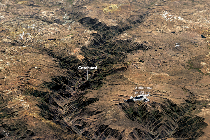
Marpa is a ruined pre-Hispanic town located along the Cotahuasi Canyon in the Andes range of southern Peru. The Cotahuasi River arises in the Wansu mountain range, cutting a route south-west and ending some 300 km later as the Ocoña River The Ocoña River ( es, Río Ocoña) is a river located in the Arequipa region in southern Peru. It helped form Peru's deep canyon walls. See also *List of rivers of Peru *List of rivers of the Americas by coastline This list of rivers of th ... mouthing into the Pacific Ocean. Declared a ''"Zona Reserva Turistica"'' in 1988 very little is known about the canyon and Marpa. Rafting expeditions first ran the canyon in 1994. In pre-Hispanic times the Inca road along the canyon was well-used, and sections have survived, as have the ruins of agricultural terraces, staircases and ancient tombs. The Inca road may have been built along the route of an older road built by the Wari culture, a dominant force in the highlands of central a ... [...More Info...] [...Related Items...] OR: [Wikipedia] [Google] [Baidu] |
La Unión Province, Peru
La Unión is a province of the Arequipa Region in Peru. Its seat is Cotahuasi. Geography The Huanzo mountain range traverses the province. One of the highest peaks of the province is Solimana at . Other mountains are listed below:escale.minedu.gob.pe - UGEL map of the Chumbivilcas Province (Cusco Region) Political division The province is divided into eleven districts which are * Alca * Charcana *Cotahuasi (Province Seat) * Huaynacotas * Pampamarca * Puyca * Quechualla * Sayla * Tauria * Tomepampa * Toro Ethnic groups The people in the province are mainly indigenous citizens of Quechua descent. Quechua is the language which the majority of the population (59.18%) learnt to speak in childhood, 40.06% of the residents started speaking using the Spanish language (2007 Peru Census). INEI, Peru, Censos Naci ... [...More Info...] [...Related Items...] OR: [Wikipedia] [Google] [Baidu] |
Arequipa Region
Arequipa ( ay, Ariqipa; qu, Ariqipa) is a department and region in southwestern Peru. It is the sixth largest department in Peru, after Puno, Cuzco, Madre de Dios, Ucayali, and Loreto, its sixth most populous department, and its eleventh least densely populated department. It is bordered by the departments of Ica, Ayacucho, Apurímac and Cusco in the north, the Department of Puno in the east, the Department of Moquegua in the south, and the Pacific Ocean in the west. Its capital, also called Arequipa, is Peru's second-largest city. Geography This department has a rough topography, which is characterised by heavy layers of volcanic lava covering large areas of its inter- Andean sector. It has deep canyons such as the ones formed by the Ocoña and Majes rivers. Plateaus range in height from medium, such as La Joya, and high-altitude ones such the Arrieros Pampa and those located in the zones of Chivay, Huambo and Pichucolla. Volcanic cones, such as Misti, Chachani ... [...More Info...] [...Related Items...] OR: [Wikipedia] [Google] [Baidu] |
Pre-Columbian
In the history of the Americas, the pre-Columbian era spans from the original settlement of North and South America in the Upper Paleolithic period through European colonization, which began with Christopher Columbus's voyage of 1492. Usually, the era covers the history of Indigenous cultures until significant influence by Europeans. This may have occurred decades or even centuries after Columbus for certain cultures. Many pre-Columbian civilizations were marked by permanent settlements, cities, agriculture, civic and monumental architecture, major earthworks, and complex societal hierarchies. Some of these civilizations had long faded by the time of the first permanent European colonies (c. late 16th–early 17th centuries), and are known only through archaeological investigations and oral history. Other civilizations were contemporary with the colonial period and were described in European historical accounts of the time. A few, such as the Maya civilization, had their own ... [...More Info...] [...Related Items...] OR: [Wikipedia] [Google] [Baidu] |
Cotahuasi Canyon
Cotahuasi Canyon (from Quechua Kutawasi), near the city of Arequipa in Peru, is one of the deepest canyons in the world. With a depth of approximately , as defined as the difference in elevation at river level and the peak of a mountain alongside the canyon, it is more than twice as deep as the Grand Canyon. The Cotahuasi River eroded the canyon between two mountain massifs: the Coropuna ( ) and the Solimana ( ). It extends from spurs of the snow-covered Solimana to the confluence with the Ocoña River near the village of . The Cotahuasi River's source is Lake Wansuqucha, at more than above sea level. It receives the tributaries of the Wayllapaña River in the neighborhood of Pampamarka, to the north, and the Huarcaya near Tumipampa, to the west, and is later joined by the Maran River to form the Ocoña River, which ends at the Pacific Ocean. Location Cotahuasi is located at the highest Andean point of Arequipa, in the south of Peru : UTM 683,370 & 790,415 East & 8’275,5 ... [...More Info...] [...Related Items...] OR: [Wikipedia] [Google] [Baidu] |
Andes
The Andes, Andes Mountains or Andean Mountains (; ) are the longest continental mountain range in the world, forming a continuous highland along the western edge of South America. The range is long, wide (widest between 18°S – 20°S latitude), and has an average height of about . The Andes extend from north to south through seven South American countries: Venezuela, Colombia, Ecuador, Peru, Bolivia, Chile, and Argentina. Along their length, the Andes are split into several ranges, separated by intermediate depressions. The Andes are the location of several high plateaus—some of which host major cities such as Quito, Bogotá, Cali, Arequipa, Medellín, Bucaramanga, Sucre, Mérida, El Alto and La Paz. The Altiplano plateau is the world's second-highest after the Tibetan plateau. These ranges are in turn grouped into three major divisions based on climate: the Tropical Andes, the Dry Andes, and the Wet Andes. The Andes Mountains are the highest mountain ra ... [...More Info...] [...Related Items...] OR: [Wikipedia] [Google] [Baidu] |
Peru
, image_flag = Flag of Peru.svg , image_coat = Escudo nacional del Perú.svg , other_symbol = Great Seal of the State , other_symbol_type = Seal (emblem), National seal , national_motto = "Firm and Happy for the Union" , national_anthem = "National Anthem of Peru" , march = "March of Flags" , image_map = PER orthographic.svg , map_caption = , image_map2 = , capital = Lima , coordinates = , largest_city = capital , official_languages = Peruvian Spanish, Spanish , languages_type = Co-official languages , languages = , ethnic_groups = , ethnic_groups_year = 2017 , demonym = Peruvians, Peruvian , government_type = Unitary state, Unitary Semi-presidential system, semi-presidential republic , leader_title1 = President of Peru, President ... [...More Info...] [...Related Items...] OR: [Wikipedia] [Google] [Baidu] |
Wansu Mountain Range
The Huanzo mountain range (possibly from in the Quechua spelling ''Wansu'') lies in the Andes of Peru. It extends between 14°30 and 15°01'S and 72°10 and 73°15W for about 57 km.usgs.gov USGS, Peruvian Cordilleras (Note: Coordinates 72°50' might be wrong as Waych'awi is the highest mountain in the range according to this site.)Inventario Nacional de Glaciares y Lagunas, Inventario de Glaciares del Perú, ANA (Autoridad Nacional del Agua), Huaraz 2014 (see sketch map of the Waych'awi glaciar under 'Cordillera Huanzo') It is situated in the , |
Ocoña River
The Ocoña River ( es, Río Ocoña) is a river located in the Arequipa region in southern Peru. It helped form Peru's deep canyon walls. See also *List of rivers of Peru *List of rivers of the Americas by coastline This list of rivers of the Americas by coastline includes the major coastal rivers of the Americas arranged by country. A link to a map of rivers with known coordinates is listed at right. The ocean coasts are demarcated as follows: *Arctic O ... References Rivers of Peru Rivers of Arequipa Region {{Peru-river-stub ... [...More Info...] [...Related Items...] OR: [Wikipedia] [Google] [Baidu] |
Pacific Ocean
The Pacific Ocean is the largest and deepest of Earth's five oceanic divisions. It extends from the Arctic Ocean in the north to the Southern Ocean (or, depending on definition, to Antarctica) in the south, and is bounded by the continents of Asia and Oceania in the west and the Americas in the east. At in area (as defined with a southern Antarctic border), this largest division of the World Ocean—and, in turn, the hydrosphere—covers about 46% of Earth's water surface and about 32% of its total surface area, larger than Earth's entire land area combined .Pacific Ocean . '' Britannica Concise.'' 2008: Encyclopædia Britannica, Inc. The centers of both the [...More Info...] [...Related Items...] OR: [Wikipedia] [Google] [Baidu] |
Inca
The Inca Empire (also known as the Incan Empire and the Inka Empire), called ''Tawantinsuyu'' by its subjects, ( Quechua for the "Realm of the Four Parts", "four parts together" ) was the largest empire in pre-Columbian America. The administrative, political and military center of the empire was in the city of Cusco. The Inca civilization arose from the Peruvian highlands sometime in the early 13th century. The Spanish began the conquest of the Inca Empire in 1532 and by 1572, the last Inca state was fully conquered. From 1438 to 1533, the Incas incorporated a large portion of western South America, centered on the Andean Mountains, using conquest and peaceful assimilation, among other methods. At its largest, the empire joined modern-day Peru, what are now western Ecuador, western and south central Bolivia, northwest Argentina, the southwesternmost tip of Colombia and a large portion of modern-day Chile, and into a state comparable to the historical empires of Eura ... [...More Info...] [...Related Items...] OR: [Wikipedia] [Google] [Baidu] |
Wari Culture
The Wari ( es, Huari) were a Middle Horizon civilization that flourished in the south-central Andes and coastal area of modern-day Peru, from about 500 to 1000 AD. Wari, as the former capital city was called, is located north-east of the modern city of Ayacucho, Peru. This city was the center of a civilization that covered much of the highlands and coast of modern Peru. The best-preserved remnants, beside the Wari Ruins, are the recently discovered Northern Wari ruins near the city of Chiclayo, and Cerro Baúl in Moquegua. Also well-known are the Wari ruins of Pikillaqta ("Flea Town"), a short distance south-east of Cuzco ''en route'' to Lake Titicaca. However, there is still a debate whether the Wari dominated the Central Coast or the polities on the Central Coast were commercial states capable of interacting with the Wari people without being politically dominated by them. History Archaeological evidence points toward the Wari empire taking control of a number of s ... [...More Info...] [...Related Items...] OR: [Wikipedia] [Google] [Baidu] |
Archaeological Sites In Peru
Archaeological sites in Peru are numerous and diverse, representing different aspects including temples and fortresses of the various cultures of ancient Peru, such as the Moche and Nazca. The sites vary in importance from small local sites to UNESCO World Heritage sites of global importance. Their nature and complexity of the sites vary from small single-featured sites such as pyramids to entire cities, such as Chan Chan and Machu Picchu. Preservation and investigation of these sites are controlled mainly by the Culture Ministry (MINCUL) ( es, Ministerio de Cultura (Perú)). The lack of funding to protect sites and enforce existing laws, results in large scale looting and illegal trading of artifacts. Sites The following is an alphabetical list of archaeological sites in Peru, it lists the main archaeological sites of touristic importance as published by the Ministry of Foreign Commerce and Tourism. Archaeology of PeruArchaeological sites Retrieved March 3, 2009. See also * ... [...More Info...] [...Related Items...] OR: [Wikipedia] [Google] [Baidu] |


.jpg)
.jpg)

