|
Loch Alsh
Loch Alsh (, "foaming lake") is a sea inlet between the isle of Skye in the Inner Hebrides and the Northwest Highlands of Scotland. The name is also used to describe the surrounding country and the feudal holdings around the loch. The area is rich in history, and is increasingly popular with tourists. The hilly country around Loch Alsh has a temperate, well-watered climate. There is some pasture and woodland, but much of the area is moorland. The rocks are ancient Precambrian Gneiss, some of the oldest in the world, much eroded. Location The loch runs inland about from Kyle of Lochalsh to Ardelve. From there Loch Duich continues southeast another to Shiel Bridge while Loch Long runs deeper into the mountains to the northeast. A narrow strait from the south of Loch Alsh leads to the Sound of Sleat that separates the Isle of Skye from the mainland. The loch is overlooked by Sgurr na Coinnich, which rises to on Skye. The mainland hills to the north reach at the summ ... [...More Info...] [...Related Items...] OR: [Wikipedia] [Google] [Baidu] |
Sea Loch
''Loch'' ( ) is a word meaning "lake" or "inlet, sea inlet" in Scottish Gaelic, Scottish and Irish Gaelic, subsequently borrowed into English. In Irish contexts, it often appears in the anglicized form "lough". A small loch is sometimes called a lochan. Lochs which connect to the sea may be called "sea lochs" or "sea loughs". Background This name for a body of water is Insular Celtic languages, Insular CelticThe current form has currency in the following languages: Scottish Gaelic, Irish language, Irish, Manx language, Manx, and has been borrowed into Scots language, Lowland Scots, Scottish English, Irish English and Standard English. in origin and is applied to most lakes in Scotland and to many sea inlets in the west and north of Scotland. Many of the loughs in Northern England have also previously been called "meres" (a Northern English dialect word for "lake", and an archaic Standard English word meaning "a lake that is broad in relation to its depth"), similar to th ... [...More Info...] [...Related Items...] OR: [Wikipedia] [Google] [Baidu] |
Moorland
Moorland or moor is a type of Habitat (ecology), habitat found in upland (geology), upland areas in temperate grasslands, savannas, and shrublands and the biomes of montane grasslands and shrublands, characterised by low-growing vegetation on Soil pH, acidic soils. Moorland today generally means uncultivated hill land (such as Dartmoor in South West England), but also includes low-lying wetlands (such as Sedgemoor, also South West England). It is closely related to heath, although experts disagree on the exact distinction between these types of vegetation. Generally, moor refers to Highland (geography), highland and high rainfall areas, while heath refers to lowland zones which are more likely to be the result of human activity. Moorland habitats are found mainly in Tropics, tropical Africa, Northern Europe, northern and western Europe, and South America. Most of the world's moorlands are diverse ecosystems. In the extensive moorlands of the tropics, biodiversity can be extremely ... [...More Info...] [...Related Items...] OR: [Wikipedia] [Google] [Baidu] |
Granite
Granite ( ) is a coarse-grained (phanerite, phaneritic) intrusive rock, intrusive igneous rock composed mostly of quartz, alkali feldspar, and plagioclase. It forms from magma with a high content of silica and alkali metal oxides that slowly cools and solidifies underground. It is common in the continental crust of Earth, where it is found in igneous intrusions. These range in size from dike (geology), dikes only a few centimeters across to batholiths exposed over hundreds of square kilometers. Granite is typical of a larger family of ''granitic rocks'', or ''granitoids'', that are composed mostly of coarse-grained quartz and feldspars in varying proportions. These rocks are classified by the relative percentages of quartz, alkali feldspar, and plagioclase (the QAPF diagram, QAPF classification), with true granite representing granitic rocks rich in quartz and alkali feldspar. Most granitic rocks also contain mica or amphibole minerals, though a few (known as leucogranites) conta ... [...More Info...] [...Related Items...] OR: [Wikipedia] [Google] [Baidu] |
Gabbro
Gabbro ( ) is a phaneritic (coarse-grained and magnesium- and iron-rich), mafic intrusive igneous rock formed from the slow cooling magma into a holocrystalline mass deep beneath the Earth's surface. Slow-cooling, coarse-grained gabbro is chemically equivalent to rapid-cooling, fine-grained basalt. Much of the Earth's oceanic crust is made of gabbro, formed at mid-ocean ridges. Gabbro is also found as plutons associated with continental volcanism. Due to its variant nature, the term ''gabbro'' may be applied loosely to a wide range of intrusive rocks, many of which are merely "gabbroic". By rough analogy, gabbro is to basalt as granite is to rhyolite. Etymology The term "gabbro" was used in the 1760s to name a set of rock types that were found in the ophiolites of the Apennine Mountains in Italy. It was named after Gabbro, a hamlet near Rosignano Marittimo in Tuscany. Then, in 1809, the German geologist Christian Leopold von Buch used the term more restrictively in his d ... [...More Info...] [...Related Items...] OR: [Wikipedia] [Google] [Baidu] |
Lewisian Complex
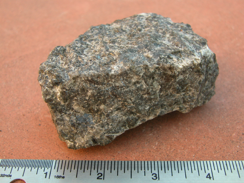
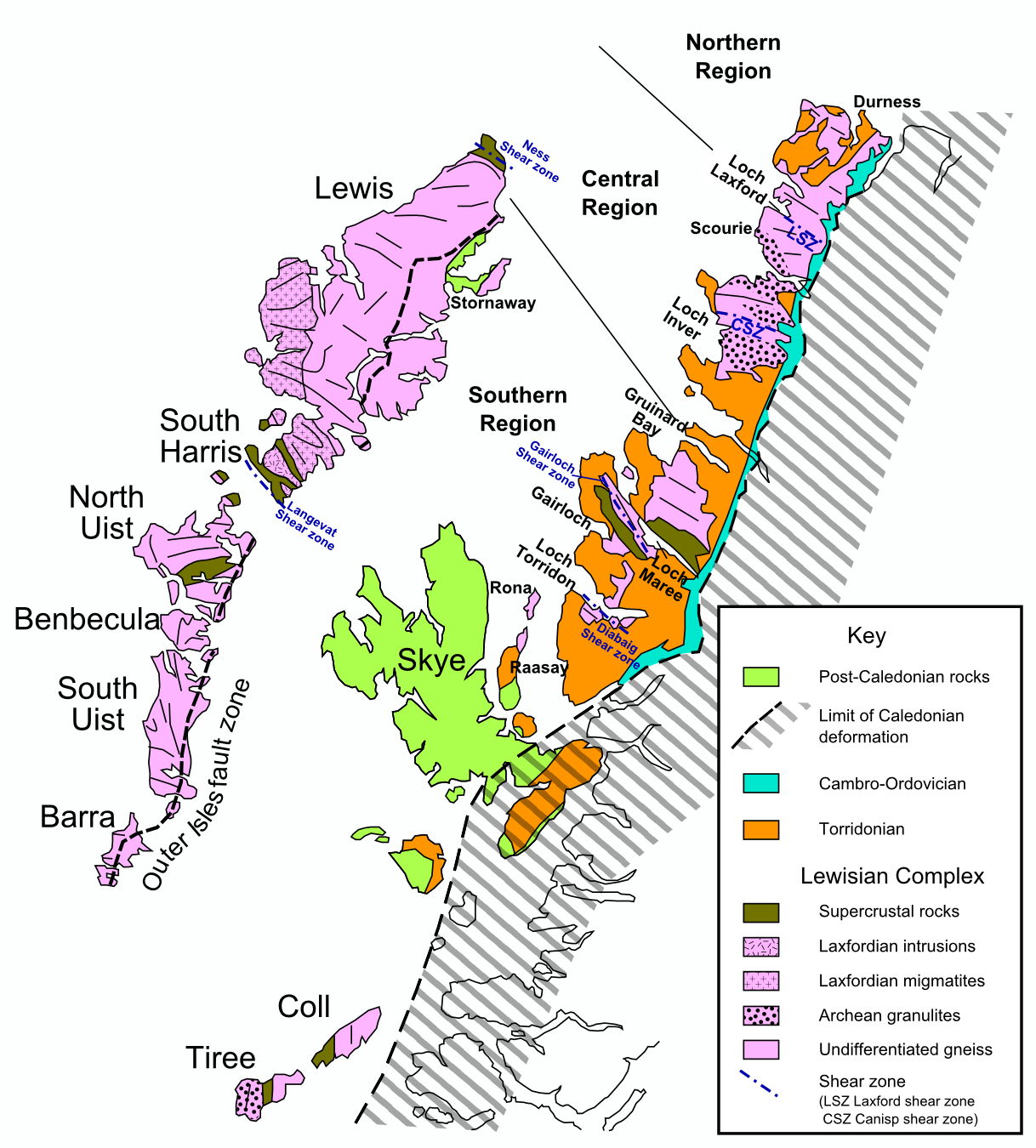
The Lewisian complex or Lewisian gneiss is a suite of Precambrian metamorphic rocks that outcrop in the northwestern part of Scotland, forming part of the Hebridean terrane and the North Atlantic craton, North Atlantic Craton. These rocks are of Archean, Archaean and Paleoproterozoic age, ranging from 3.0–1.7 billion years (Year#SI prefix multipliers, Ga). They form the Basement (geology), basement on which the Stoer Group, Wester Ross Supergroup and probably the Loch Ness Supergroup sediments were deposited. The Lewisian consists mainly of Granite, granitic gneisses with a minor amount of supracrustal rocks. Rocks of the Lewisian complex were caught up in the Caledonian orogeny, appearing in the hanging walls of many of the thrust faults formed during the late stages of this tectonic event. Distribution The main outcrops of the Lewisian complex are on the islands of the Outer Hebrides, including Isle of Lewis, Lewis, from which the complex takes its name. It is also exp ... [...More Info...] [...Related Items...] OR: [Wikipedia] [Google] [Baidu] |
Orogeny
Orogeny () is a mountain-mountain formation, building process that takes place at a convergent boundary, convergent plate margin when plate motion compresses the margin. An or develops as the compressed plate crumples and is tectonic uplift, uplifted to form one or more mountain ranges. This involves a series of geological processes collectively called orogenesis. These include both structural deformation (physics), deformation of existing continental crust and the creation of new continental crust through volcanism. Magma rising in the orogen carries less dense material upwards while leaving more dense material behind, resulting in compositional differentiation of Earth's lithosphere (crust (geology), crust and uppermost mantle (geology), mantle). A synorogenic (or synkinematic) process or event is one that occurs during an orogeny. The word ''orogeny'' comes . Although it was used before him, the American geologist Grove Karl Gilbert, G. K. Gilbert used the term in 1890 to me ... [...More Info...] [...Related Items...] OR: [Wikipedia] [Google] [Baidu] |
Loch Eriboll
__NOTOC__ Loch Eriboll (Scottish Gaelic: "Loch Euraboil") is a long sea loch on the north coast of Scotland, which has been used for centuries as a deep water anchorage as it is safe from the often stormy seas of Cape Wrath and the Pentland Firth. Bronze Age remains can be found in the area, including a souterrain and a very well preserved wheelhouse on the hillside above the west shore. A small scale lime industry developed here in the 19th century and Ard Neakie, a promontory on the eastern shore of the loch, had four large lime kilns developed in around 1870.Ard Neackie, Limekilns, Quarry Canmore. Retrieved 11 April 2021. Before the development of the coast road around the loch in 1890, the Heilam ferry ran from the quay at |
Moine Thrust Belt
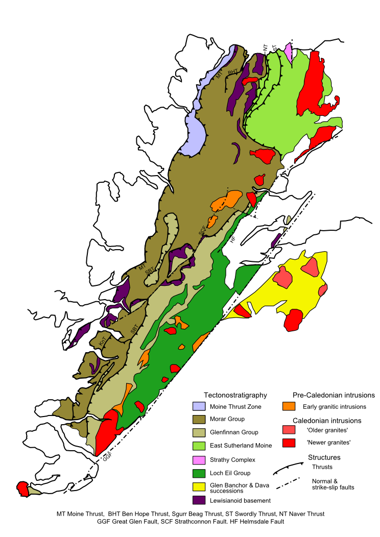
The Moine Thrust Belt or Moine Thrust Zone is a linear tectonic feature in the Scottish Highlands which runs from Loch Eriboll on the north coast southwest to the Sleat peninsula on the Isle of Skye. The thrust belt consists of a series of thrust faults that branch off the Moine Thrust itself. Topographically, the belt marks a change from rugged, terraced mountains with steep sides sculptured from weathered igneous, sedimentary and metamorphic rocks in the west to an extensive landscape of rolling hills over a metamorphic rock base to the east. Mountains within the belt display complexly folded and faulted layers and the width of the main part of the zone varies up to , although it is significantly wider on Skye. Discovery The presence of metamorphic gneisses and schists lying apparently stratigraphically above sedimentary rocks of lower Paleozoic age in the Northwest Highlands had been known since the early 19th century, convincing Roderick Murchison that the change was a ... [...More Info...] [...Related Items...] OR: [Wikipedia] [Google] [Baidu] |
Highland Clearances
The Highland Clearances ( , the "eviction of the Gaels") were the evictions of a significant number of tenants in the Scottish Highlands and Islands, mostly in two phases from 1750 to 1860. The first phase resulted from Scottish Agricultural Revolution, agricultural improvement, driven by the need for landlords to increase their income – many had substantial debts, with actual or potential bankruptcy being a large part of the story of the clearances. This involved the enclosure of the Open-field system, open fields managed on the run rig system and shared grazing. These were usually replaced with large-scale Pastoral farming, pastoral farms on which much higher rents were paid. The displaced tenants were expected to be employed in industries such as fishing, quarrying, or Kelp#Uses, kelp harvesting and processing. Their reduction in status from farmer to Croft (land), crofter was one of the causes of resentment. The second phase involved overcrowded crofting communities from ... [...More Info...] [...Related Items...] OR: [Wikipedia] [Google] [Baidu] |
Croft (land)
A croft is a traditional Scottish term for a fenced or enclosed area of land, usually small and arable, and usually, but not always, with a crofter's dwelling thereon. A crofter is one who has tenure and use of the land, typically as a tenant farmer, especially in rural areas. In Northern England, ''crofter'' was a term connected with tenant farming and rural employment. For example in the textiles industry; someone who bleached cloth prior to dyeing, laying it out in fields or 'crofts'. Etymology The word ''croft'' is West Germanic in etymology, derived from the Dutch term ''kroft'' or ''krocht'' and the Old English ''croft'' (itself of debated origin), meaning an enclosed field. Today, the term is used most frequently in Scotland, most crofts being in the Highlands and Islands area. Elsewhere the expression is generally archaic. In Scottish Gaelic, it is rendered (, plural ). Legislation in Scotland The Scottish croft is a small agricultural landholding of a type ... [...More Info...] [...Related Items...] OR: [Wikipedia] [Google] [Baidu] |
Forestry Commission
The Forestry Commission is a non-ministerial government department responsible for the management of publicly owned forests and the regulation of both public and private forestry in England. The Forestry Commission was previously also responsible for forestry in Wales and Scotland. However, on 1 April 2013, Forestry Commission Wales merged with other agencies to become Natural Resources Wales, whilst two new bodies (Forestry and Land Scotland and Scottish Forestry) were established in Scotland on 1 April 2019. The Forestry Commission was established in 1919 to expand Britain's forests and woodland, which had been severely depleted during the First World War. The Commission bought large amounts of agricultural land on behalf of the state, eventually becoming the largest manager of land in Britain. Today, the Forestry Commission is divided into three divisions: Forestry England, Forestry Commission and Forest Research. Over time the purpose of the Commission broadened to include ... [...More Info...] [...Related Items...] OR: [Wikipedia] [Google] [Baidu] |
Conifer
Conifers () are a group of conifer cone, cone-bearing Spermatophyte, seed plants, a subset of gymnosperms. Scientifically, they make up the phylum, division Pinophyta (), also known as Coniferophyta () or Coniferae. The division contains a single extant class (biology), class, Pinopsida. All Neontology, extant conifers are perennial plant, perennial woody plants with secondary growth. The majority are trees, though a few are shrubs. Examples include Cedrus, cedars, Pseudotsuga, Douglas-firs, Cupressaceae, cypresses, firs, junipers, Agathis, kauri, larches, pines, Tsuga, hemlocks, Sequoioideae, redwoods, spruces, and Taxaceae, yews.Campbell, Reece, "Phylum Coniferophyta". ''Biology''. 7th ed. 2005. Print. p. 595. As of 2002, Pinophyta contained seven families, 60 to 65 genera, and more than 600 living species. Although the total number of species is relatively small, conifers are ecology, ecologically important. They are the dominant plants over large areas of land, most notably ... [...More Info...] [...Related Items...] OR: [Wikipedia] [Google] [Baidu] |


