|
Letterard
Letterard () is a townland located in the parish of Moyrus or Carna, Connemara on the West Coast of the Republic of Ireland. It is located in County Galway. To the west of Letterard is Bertrabhoy Bay. Across the bay from Letterard is Roundstone. The word Letterard itself means high area which is noteworthy as the townland is located on an elevated area on the peninsula. Bordering the Bay area is a cliff on called ''Áill Dá Bhinn''. This translates to the cliff with the two peaks. During the feudal ages a demesne lodge was located in Letterard. This belonged to a tenant in demesne who came under the landlord located in Knockboy House just outside Carna village. The ruins of the lodge are still to be found in the Eastern half of Letterard. Population Letterard has an overall population of 103. It is also located in the Connemara Gaeltacht. Before the Great Famine struck Ireland the population of Letterard was around 800 people and it dramatically dropped to just over 100 by th ... [...More Info...] [...Related Items...] OR: [Wikipedia] [Google] [Baidu] |
Carna, County Galway
Carna is an area in Connemara, County Galway, Ireland. It is located on the country's west coast in the Gaeltacht, about 50 km west of Galway city. Carna is an extremely small area, but as a focal point for the surrounding areas, it contains a Garda Síochána station, a Health Centre including a Rapid Response Ambulance, and an Irish Coastguard lifeboat. Carna is not located close to any villages. The population dramatically dropped from the previous average of 8,000 before the Great Famine (Ireland), Great Famine. The age of the average resident is significantly higher than the Irish national average. The National University of Ireland, Galway, has an Irish language, Irish-language and educational centre (''Áras Shorcha Ní Ghuairim'') in Roisín na Mainiach, near Carna. It also operates a marine biology station Martin Ryan Institute in Maínis and an atmospheric Mace Head Atmospheric Research Station, research station at Mace Head, Carna, which is run by the universit ... [...More Info...] [...Related Items...] OR: [Wikipedia] [Google] [Baidu] |
Townland
A townland (; Ulster-Scots: ''toonlann'') is a traditional small land division used in Ireland and in the Western Isles of Scotland, typically covering . The townland system is of medieval Gaelic origin, predating the Norman invasion, and most have Irish-derived names. However, some townland names and boundaries come from Norman manors, plantation divisions, or later creations of the Ordnance Survey.Connolly, S. J., ''The Oxford Companion to Irish History, page 577. Oxford University Press, 2002. ''Maxwell, Ian, ''How to Trace Your Irish Ancestors'', page 16. howtobooks, 2009. Townlands cover the whole island of Ireland, and the total number of inhabited townlands in Ireland was 60,679 in 1911. The total number recognised by the Placenames Database of Ireland as of 2014 was 61,098, including uninhabited townlands. Etymology The term "townland" in English is derived from the Old English word ''tūn'', denoting an enclosure. The term describes the smallest unit of land di ... [...More Info...] [...Related Items...] OR: [Wikipedia] [Google] [Baidu] |
Republic Of Ireland
Ireland ( ), also known as the Republic of Ireland (), is a country in Northwestern Europe, north-western Europe consisting of 26 of the 32 Counties of Ireland, counties of the island of Ireland, with a population of about 5.4 million. Its capital city, capital and largest city is Dublin, on the eastern side of the island, with a population of over 1.5 million. The sovereign state shares its only land border with Northern Ireland, which is Countries of the United Kingdom, part of the United Kingdom. It is otherwise surrounded by the Atlantic Ocean, with the Celtic Sea to the south, St George's Channel to the south-east and the Irish Sea to the east. It is a Unitary state, unitary, parliamentary republic. The legislature, the , consists of a lower house, ; an upper house, ; and an elected President of Ireland, president () who serves as the largely ceremonial head of state, but with some important powers and duties. The head of government is the (prime minister, ), ... [...More Info...] [...Related Items...] OR: [Wikipedia] [Google] [Baidu] |
Demesne
A demesne ( ) or domain was all the land retained and managed by a lord of the manor under the feudal system for his own use, occupation, or support. This distinguished it from land subinfeudation, sub-enfeoffed by him to others as sub-tenants. In contrast, the entire territory controlled by a monarch both directly and indirectly via their tenant lords would typically be referred to as their realm. The concept originated in the Kingdom of France and found its way to foreign lands influenced by it or its fiefdoms. In England, Wales and Northern Ireland, royal demesne is the land held by the Monarch, Crown, and ancient demesne is the legal term for the land held by the king at the time of the Domesday Book in 1086. Etymology The word derives from Old French , ultimately from Latin , "lord, master of a household" – ''demesne'' is a variant of ''domaine''. The word ''barton'', which is historically synonymous to ''demesne'' and is an element found in many place-names, can refer t ... [...More Info...] [...Related Items...] OR: [Wikipedia] [Google] [Baidu] |
Connemara
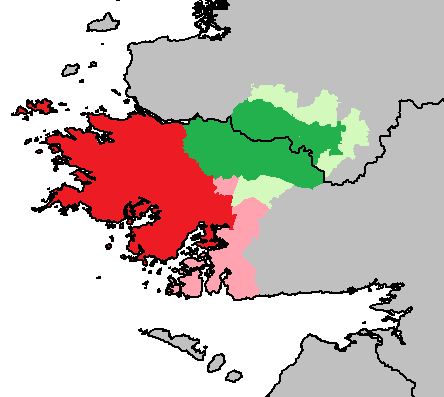
Connemara ( ; ) is a region on the Atlantic Ocean, Atlantic coast of western County Galway, in the west of Ireland. The area has a strong association with traditional Irish culture and contains much of the Connacht Irish-speaking Gaeltacht, which is a key part of the identity of the region and is the largest Gaeltacht in the country. Historically, Connemara was part of the territory of Iar Connacht (West Connacht). Geographically, it has many mountains (notably the Twelve Pins), peninsulas, coves, islands and small lakes. Connemara National Park is in the northwest. It is mostly rural and its largest settlement is Clifden. Etymology "Connemara" derives from the tribal name , which designated a branch of the , an early tribal grouping that had a number of branches located in different parts of . Since this particular branch of the lived by the sea, they became known as the (sea in Irish is , genitive case, genitive , hence "of the sea"). Definition One common definition o ... [...More Info...] [...Related Items...] OR: [Wikipedia] [Google] [Baidu] |
Gaeltacht
A ( , , ) is a district of Ireland, either individually or collectively, where the Irish government recognises that the Irish language is the predominant vernacular, or language of the home. The districts were first officially recognised during the 1920s in the early years of the Irish Free State, following the Gaelic revival, as part of a government policy aimed at restoring the Irish language. The is threatened by serious language decline. Research published in 2015 showed that Irish is spoken on a daily basis by two-thirds or more of the population in only 21 of the 155 electoral divisions in the . Daily language use by two-thirds or more of the population is regarded by some academics as a tipping point for language survival.RTÉ News Report of Friday 29 May 2015 History In 1926, the official was designated as a result of the report of the first Gaeltacht Commission ''Coimisiún na Gaeltachta''. The exact boundaries were not defined. At the time, an area was clas ... [...More Info...] [...Related Items...] OR: [Wikipedia] [Google] [Baidu] |
Great Famine (Ireland)
The Great Famine, also known as the Great Hunger ( ), the Famine and the Irish Potato Famine, was a period of mass starvation and disease in Ireland lasting from 1845 to 1852 that constituted a historical social crisis and had a major impact on Irish society and history as a whole. The most severely affected areas were in the western and southern parts of Ireland—where the Irish language was dominant—hence the period was contemporaneously known in Irish as , which literally translates to "the bad life" and loosely translates to "the hard times". The worst year of the famine was 1847, which became known as "Black '47".Éamon Ó Cuív – the impact and legacy of the Great Irish Famine The population of Ireland on the eve of the famine was about 8.5 million; by 1901, it was just 4.4 million. During the Great Hunger, roughly 1 million people died and more than 1 million more Irish diaspora, fled the country, causing the country's population to fall by 20–25% between 18 ... [...More Info...] [...Related Items...] OR: [Wikipedia] [Google] [Baidu] |
Irish War Of Independence
The Irish War of Independence (), also known as the Anglo-Irish War, was a guerrilla war fought in Ireland from 1919 to 1921 between the Irish Republican Army (1919–1922), Irish Republican Army (IRA, the army of the Irish Republic) and United Kingdom of Great Britain and Ireland, British forces: the British Army, along with the quasi-military Royal Irish Constabulary (RIC) and its paramilitary forces the Auxiliary Division, Auxiliaries and Ulster Special Constabulary (USC). It was part of the Irish revolutionary period. In April 1916, Irish republicanism, Irish republicans launched the Easter Rising against British rule in Ireland, British rule and Proclamation of the Irish Republic, proclaimed an Irish Republic. Although it was defeated after a week of fighting, the Rising and the British response led to greater popular support for Irish independence. In the 1918 Irish general election, December 1918 election, republican party Sinn Féin won a landslide victory in Ireland. O ... [...More Info...] [...Related Items...] OR: [Wikipedia] [Google] [Baidu] |
Irish Republican Army
The Irish Republican Army (IRA) is a name used by various Resistance movement, resistance organisations in Ireland throughout the 20th and 21st centuries. Organisations by this name have been dominantly Catholic and dedicated to anti-imperialism through Irish republicanism, the belief that all of Ireland should be an independent republic free from British colonial rule. The original Irish Republican Army (1919–1922), often now referred to as the "old IRA", was raised in 1917 from members of the Irish Volunteers and the Irish Citizen Army later reinforced by Irishmen formerly in the British Army in World War I, who returned to Ireland to fight against Britain in the Irish War of Independence. In Irish law, this IRA was the army of the revolutionary republic, revolutionary Irish Republic as declared by its parliament, Dáil Éireann (Irish Republic), Dáil Éireann, in 1919. In the century that followed, the original IRA was reorganised, changed and split on multiple occasions ... [...More Info...] [...Related Items...] OR: [Wikipedia] [Google] [Baidu] |
Roundstone, County Galway
Roundstone () is a village on the west coast of Ireland, in the Connemara region of County Galway. Lying opposite the island of Inishnee on Roundstone Bay, by road it is northwest of Galway and southeast of Clifden. Known as a haven for people in the creative arts, it hosts an annual regatta in July. Etymology The anglicised name is usually considered an error on the part of the British colonial Ordnance Survey, which translated the village name; while ''Cloch'' certainly means "stone" or "rock", ''Rón'' means "seal", not "round". Still, the names Cloch na Rón and Roundstone may be totally independent. The bay is referred to as Round-stone Haven as early as 1684 ( Roderick O'Flaherty), and the rock after which it is named stands like a marker at the entrance and is strikingly round. History The area to the north of Roundstone was ruled by the Chiefs of Clan O'Flaherty, who built a Dominican Priory about to the north of what is now Roundstone in the 15th-century. Rounds ... [...More Info...] [...Related Items...] OR: [Wikipedia] [Google] [Baidu] |


