|
Kitti (municipality)
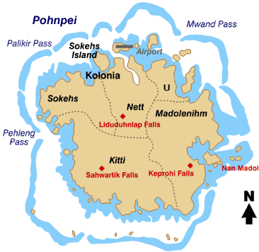
Kitti, also written as Kiti, is one of the twelve administrative divisions of the Micronesian state of Pohnpei. It is located in the southwest of the island of Pohnpei, to the south of Mount Nanlaud. Education Pohnpei State Department of Education operates public schools: * Nanpei Memorial High School a.k.a. Kitti High School * Enipein School * Nanpei Memorial Elementary School * Pehleng Elementary School * Rohi Elementary School * Salapwuk Elementary School * Seinwar Elementary School * Wone Elementary School See also * Madolenihmw * Sokehs * U, Pohnpei * Nett * Kapingamarangi * Pingelap * Sapwuahfik * Nukuoro * Mokil * Kolonia * Oroluk * Palikir * Uhsapw Climate Kitti has a tropical rainforest climate A tropical rainforest climate or equatorial climate is a tropical climate sub-type usually found within 10 to 15 degrees latitude of the equator. There are some other areas at higher latitudes, such as the coast of southeast Florida, United States ... (Af) wi ... [...More Info...] [...Related Items...] OR: [Wikipedia] [Google] [Baidu] |
Pohnpei Map
Pohnpei (formerly known as Ponape or Ascension, from Pohnpeian: "upon (''pohn'') a stone altar (''pei'')") is an island of the Senyavin Islands which are part of the larger Caroline Islands group. It belongs to Pohnpei State, one of the four states in the Federated States of Micronesia (FSM). Major population centers on Pohnpei include Palikir, the FSM's capital, and Kolonia, the capital of Pohnpei State. Pohnpei is the largest island in the FSM, with an area of , and a highest point of , the most populous with 36,832 people, and the most developed single island in the FSM. Pohnpei is home to the megaliths and ruined city of Nan Madol, built of artificial islands off the island's eastern shore beginning in the 8th or 9th century. An important archaeological site, it was declared a national historic site in 1985. Pohnpei contains a wealth of biodiversity. It is one of the wettest places on Earth with annual recorded rainfall exceeding each year in certain mountainous locati ... [...More Info...] [...Related Items...] OR: [Wikipedia] [Google] [Baidu] |
Kapingamarangi
Kapingamarangi is an atoll and a municipality in the state of Pohnpei of the Federated States of Micronesia. It is by far the most southerly atoll or island of the country and the Caroline Islands, south of the next southerly atoll, Nukuoro, and southwest of the main island of Pohnpei state; it forms a Polynesian outlier. The total area of the atoll, including the lagoon, is . Out of this, is land area, spread over 33 wooded islets on the eastern side of the atoll, three of which host a population of about 500 people. The western reef rim of the atoll is almost submerged in high water. Kapingamarangi is the southernmost point of Micronesia. Population Kapingamarangi has a population of about 500 (). Several hundred Kapingamarangi people also live in Porakied village in Kolonia, Pohnpei. Their language is Polynesian. The main industry is fishing. Touhou Island, which reaches a height of and is connected to Welua Island (Ueru Island) in the north by a causeway, is t ... [...More Info...] [...Related Items...] OR: [Wikipedia] [Google] [Baidu] |
Uhsapw
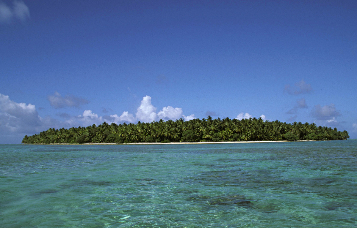
Uhsapw is a small island off the south coast of Pohnpei in the Federated States of Micronesia The Federated States of Micronesia (, abbreviated FSM), or simply Micronesia, is an island country in Micronesia, a region of Oceania. The federation encompasses the majority of the Caroline Islands (excluding Palau) and consists of four Admin .... It lies near Enipein Pah in southern Kitti Municipality. It is covered in greenery, with a small landing point on its western shore. References Islands of the Federated States of Micronesia Geography of Pohnpei {{Micronesia-geo-stub ... [...More Info...] [...Related Items...] OR: [Wikipedia] [Google] [Baidu] |
Palikir
Palikir () is the Capital city, capital city of the Federated States of Micronesia located in the western Pacific Ocean. A town of slightly under 5,000 residents, it is part of the larger Sokehs municipality, which had a population of 6,647 , out of the nation's total population of 106,487. It is situated on the northwest side of Pohnpei island (population 34,789), a high volcanic island surrounded by a fringing coral reef. Nearby to the northeast is the island's largest settlement, the coastal town of Kolonia. It was declared the capital of Micronesia in 1989. History Pohnpei was ruled by tribal chiefs in ancient times. Palikir was formerly a tiny village of little consequence. The island of Pohnpei was encountered by the Portuguese and Spanish in the 15th century, but colonial settlement did not occur until 1886 by the Spanish. Later Germany attained the Caroline Islands via purchase from Spain at the end of the Spanish–American War in 1898. During World War I control passed ... [...More Info...] [...Related Items...] OR: [Wikipedia] [Google] [Baidu] |
Oroluk
Oroluk was one of the administrative divisions of Pohnpei State, Federated States of Micronesia. In 1985, it became part of Sokehs Municipality. Description Oroluk municipality included Oroluk Atoll and Minto Reef. This municipality is uninhabited, after a population of 6 was counted in the 1980 census. Minto Reef, the northwesternmost limit of Pohnpei State, is uninhabited and has only a small sandbank with no vegetated islands. See also * Madolenihmw * Kitti (municipality) * U, Pohnpei * Nett, Pohnpei, Nett * Kapingamarangi * Pingelap * Sapwuahfik * Nukuoro * Mokil * Kolonia * Sokehs * Palikir References External linksTrust Territory of the Pacific Islands - General Population Characteristics, 1980* POHNPEI (Islas Carolinas orientales). 3º parte. Ngatik and Oroluk (Spanish) {{coord, 7, 26, 47, N, 155, 21, 30, E, display=title Municipalities of Pohnpei it:Oroluk ... [...More Info...] [...Related Items...] OR: [Wikipedia] [Google] [Baidu] |
Kolonia
Kolonia is a coastal town and the capital of Pohnpei State in the Federated States of Micronesia (FSM). It's not to be confused with the far smaller Colonia, the capital of the State of Yap. It was also the former FSM capital before being replaced by Palikir in 1989, located nearby to the southwest in the municipality of Sokehs. It has 6,074 people. Description Kolonia Town is located in the north central section of Pohnpei Island. It was formerly part of Nett municipality but has been a separate municipality since May 1965. The population of the town was 6,074 (2010 Census). It is the largest population center on Pohnpei and the commercial hub of the island. The land area of Kolonia amounts to 1.5 km2, with a large number of buildings lying just outside the town limits. The official languages are Pohnpeian and English. Mercedarian Missionaries speak Spanish. History Kolonia's history is deeply marked by Pohnpei's multiple foreign occupiers, and evidence of their ... [...More Info...] [...Related Items...] OR: [Wikipedia] [Google] [Baidu] |
Nukuoro
Nukuoro is an atoll in the Federated States of Micronesia. It is a municipality of the state of Pohnpei, Federated States of Micronesia. It is the secondmost southern atoll of the country, after Kapingamarangi. They both are Polynesian outliers. , Nukuoro had a population of 372, though several hundred Nukuorans live on Pohnpei. Fishing, animal husbandry, and agriculture ( taro and copra) are the main occupations. A recent project to farm black pearl oysters has been successful at generating additional income for the island's people. Nukuoro is remote. It has no airstrip, and a passenger boat calls irregularly only once every few months. The island has no tourism except for the occasional visit by passing sailing yachts. There is a 4-room schoolhouse but children over the age of 14 must travel to Pohnpei to attend high school. Geography The total area, including the lagoon, is , with a land area of , which is divided among more than 40 islets that lie on the northern, ... [...More Info...] [...Related Items...] OR: [Wikipedia] [Google] [Baidu] |
Sapwuahfik
Sapwuahfik, formerly Ngatik, or the Raven Islands is a atoll in Pohnpei state of the Federated States of Micronesia. It is a village and municipality of roughly 430 people on a land area of . It is mostly known in history as the site of the Ngatik massacre. Geography It is located southwest of the main island of Pohnpei in the Eastern Caroline Islands and consists of 10 individual islands on the reef. The largest and only inhabited island is Ngatik, at the western end. The atoll is long and up to wide. The lagoon measures in area, and the total area is . The aggregate land area of the 10 islands is , of which the main island Ngatik is , or more than half. While Ngatik is the only inhabited island, the six larger of the remaining islands are used by the population for harvesting coconuts and growing taro, and animal husbandry (pigs and chickens). There are 12 buildings for temporary shelter on those islands. The islands, clockwise, starting at Ngatik in the west: Air ... [...More Info...] [...Related Items...] OR: [Wikipedia] [Google] [Baidu] |
Pingelap
Pingelap is an atoll in the Pacific Ocean, part of Pohnpei State of the Federated States of Micronesia, consisting of three islands: Pingelap Island, Sukoru and Daekae, linked by a reef system and surrounding a central lagoon, although only Pingelap Island is inhabited. The entire system has a land area of 1.8 km² (455 acres) at high-tide, and is less than at its widest point. The atoll has its own language, Pingelapese, spoken by most of the atoll's 250 residents. History The first European observer of the islands was Captain Thomas Musgrave in the ship . Captain MacAskill in revisited them in 1809. Errors in measurement of their location resulted in the islands being separately named on charts in the 19th century as the Musgrave Islands and the MacAskill islands, within the Caroline archipelago. Historically, the ''Ouwa'' or the Paramount Chief or King of Pikelap which is a hereditary title that granted supreme rule of the land, ruled the island of Pikelap which is no ... [...More Info...] [...Related Items...] OR: [Wikipedia] [Google] [Baidu] |
Nett, Pohnpei
Nett also written as Net, is one of the administrative divisions of Pohnpei State, Federated States of Micronesia. Description Nett is one of the six municipalities located in the main island of Pohnpei. It corresponds to the north-central sector of the island. The population was 6,639 as of 2010. Nett municipality formerly included Kolonia, now a separate administrative division. Nett has been historically subdivided into 23 sections, districts, or villages (''kousapw''): Parempei, Lenger, Leprohi, Sekeren, Weipowe, Diadi, Tomwara, Dolokei, Lewetik, Takaieu, Paliais, Seinwar, Meitik, Paremkep, Nansokasok (Nan Sokasok), Eirike (Eirke), Nanipil, Kahmar, Doaroapop, Pohndien, Dolakapw, Mesenieng, and Lehdau. This includes ''Mesenieng'', which is the traditional name of the now separate municipality Kolonia, which is still claimed by Nett municipality as one of its ''kousapw''. The ''kousapw'' are or were further subdivided into peliensapw (farmsteads). Education Pohnpei Stat ... [...More Info...] [...Related Items...] OR: [Wikipedia] [Google] [Baidu] |
Federated States Of Micronesia
The Federated States of Micronesia (, abbreviated FSM), or simply Micronesia, is an island country in Micronesia, a region of Oceania. The federation encompasses the majority of the Caroline Islands (excluding Palau) and consists of four Administrative divisions of the Federated States of Micronesia#States, states—from west to east: Yap State, Yap, Chuuk State, Chuuk, Pohnpei State, Pohnpei, and Kosrae—that span the western Pacific just north of the equator for a Longitude, longitudinal distance of almost . Together, the states comprise around 607 islands and a combined land area of approximately . The entire island nation lies across the northern Pacific accordingly: northeast of Indonesia and Papua New Guinea, south of Guam and the Marianas, west of Nauru and the Marshall Islands, east of Palau and the Philippines, about north of eastern Australia, southeast of Japan, and some southwest of Honolulu of the Hawaiian Islands. The country's total land area is relatively ... [...More Info...] [...Related Items...] OR: [Wikipedia] [Google] [Baidu] |


