|
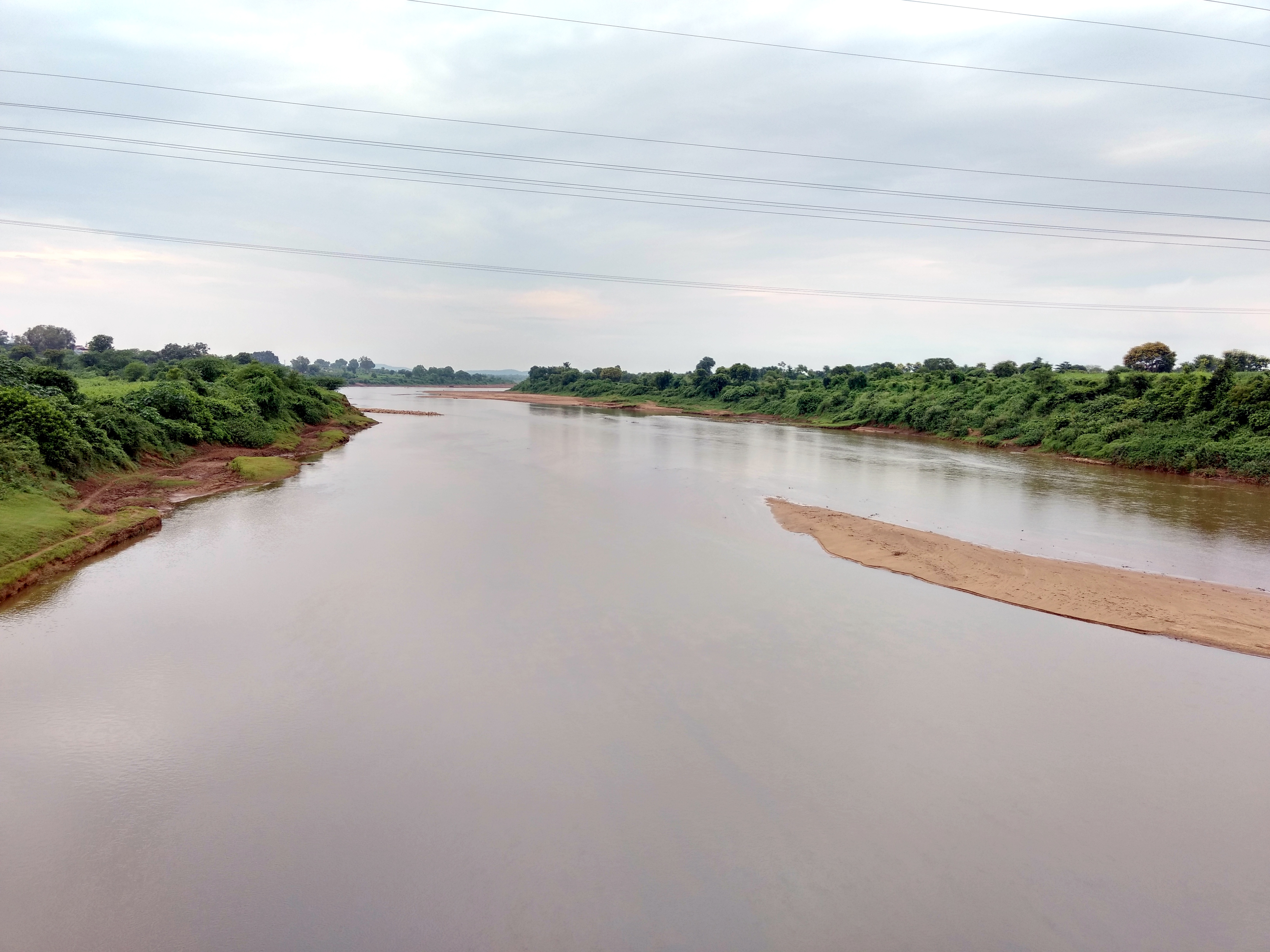
Kanhan River
The Kanhan River is an important right bank tributary of the Wainganga River draining a large area lying south of Satpura range in central India. Along its 275 km run through the Indian States of Maharashtra and Madhya Pradesh, it receives its largest tributary - Pench River, a major water source for the metropolis of Nagpur. The Kanhan was not mentioned in the 2001 list of notified rivers in Maharashtra which has led to unrestricted exploitation in the form of sand mining along the river bed. This failure to recognise its presence has been viewed as a deliberate attempt at unregulated economic gains. The catchment area has also seen largescale coal mining in recent years. Efforts are currently underway to notify the river to prevent further environmental damage. This has been undermined by plans for construction of a barrage. The river was perennial until a few decades ago, but now goes dry by February every year. Sources The Kanhan rises on the slopes of the hills at ... [...More Info...] [...Related Items...] OR: [Wikipedia] [Google] [Baidu] |
Ramkona
Ramakona is a town located in Pandhurna District of Madhya Pradesh. Geography Ramkona is located on banks of Kanhan River. It's 11 km away from Sausar Sausar (Saunsar) is a Municipal Council in the central India in the States and territories of India, state of Madhya Pradesh. Sausar lies in Vidharbha region, Nagpur is the center for all the economic activities in this region which is just 72&n .... 480106 is pin code of Ramkona. Demographics Ramkona's population is 6,144 of which 3120 are males while 3024 are females according to India's 2011 census and has 1394 families residing there. Transportation Ramkona is well connected with roadways and railway. The Ramkona railway station code is 'RMO'. Ramkona is located on NH-547 connecting Ramkona to Nagpur, Narsinghpur, Chhindwara, Saoner, Sausar, and Amarwada. References {{Jabalpur Division Cities and towns in Chhindwara district ... [...More Info...] [...Related Items...] OR: [Wikipedia] [Google] [Baidu] |
Jam River
Jam is an intermittent river in central India in southern Madhya Pradesh. It originates in Betul District and flows through Chhindwara District during its short run, ultimately draining into the Kanhan River. This confluence is located at the border with Maharashtra. An ambitious water project in the form of a dam had been proposed by Maharashtra in anticipation of the growing water needs of metro Nagpur. However the project was shelved for the time being due to lack of co-operation from the state government in Madhya Pradesh. A ''gotmar'' (stone throwing) fair, located between Sawargaon ( Savargaon) village and the town of Pandhurna, is organized every year along its banks. Course The river originates through a convergence of several rivulets and streams flowing down the hill slopes situated around Chilhati village in the Betul District in Madhya Pradesh at an altitude of 762m. Snaking along eastwards the river enters the Chhindwara District Chhindwara district () i ... [...More Info...] [...Related Items...] OR: [Wikipedia] [Google] [Baidu] |
Mauda Super Thermal Power Station
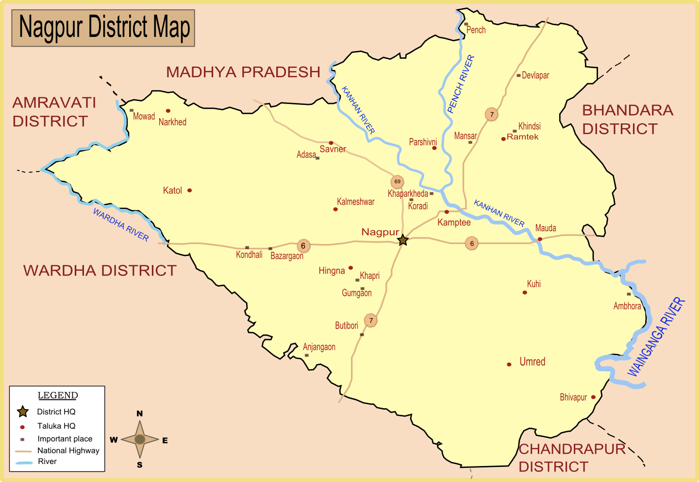
Mauda Super Thermal Power Station or NTPC Mauda is located at Mauda a Tehsil in Ramtek subdivision of Nagpur district in Nagpur revenue Division in the Berar region in the state of Maharashtra, India. The power plant is one of the coal based power plants of National Thermal Power Corporation. 1000 MW Stage 1 was dedicated to nation by Prime Minister Narendra Modi Narendra Damodardas Modi (born 17 September 1950) is an Indian politician who has served as the Prime Minister of India, prime minister of India since 2014. Modi was the chief minister of Gujarat from 2001 to 2014 and is the Member of Par ... on 21 August 2014. Bharat Heavy Electricals Limited (BHEL) is the EPC contractor (EPCC) for the power project. Capacity Gallery File: Nagpur.png, Map of Nagpur district with major towns (including Mouda) and rivers. References Coal-fired power stations in Maharashtra Nagpur district 2009 establishments in Maharashtra Energy infrastructure completed in ... [...More Info...] [...Related Items...] OR: [Wikipedia] [Google] [Baidu] |
Kolar Dam
Kolar Dam is located on 35 km south-west of Bhopal city. It is built on Kolar river which is a tributary river of Narmada river. This dam is constructed near Lawakhweri village in Sehore district. Specifications Dam water is a raw water source for Kolar Water Treatment Plant which is managed by Public Health Engineering Department of Madhya Pradesh. This plant avails approx. 153 MLD treated water to Bhopal city which is 60% of total water supply to city. Its water treatment plant is largest and best among water treatment plants arranging water supply to Bhopal city. Purpose * Irrigation and Water supply for Bhopal city See also * * List of reservoirs and dams in India This page shows the state-wise list of dams and reservoirs in India. As of July, 2019, total number of large dams in India is 5,334. About 447 large dams are under construction in India. In terms of number of dams, India ranks third after China and ... References Dams in Madhya Pradesh Year of estab ... [...More Info...] [...Related Items...] OR: [Wikipedia] [Google] [Baidu] |
Kamptee
Kamptee is a suburb of Nagpur city and a municipal council in Nagpur district in the Indian state of Maharashtra. It is part of the Nagpur metropolitan region development authority. It is the administrative center for Kamptee taluka. It is below the confluence of the Kanhan River with the rivers Pench and Kolar. History Kamptee was founded in 1821 when the British established a military cantonment on the banks of the Kanhan. Kamptee was previously named Camp-T for its shape. The town quickly became a center for trade, but trade dwindled with the arrival of the railway in the late 19th century. An Iron Age hoard of weapons was excavated by Major George Pearse of the Royal Artillery from the Wurreegaon barrow near Kamptee in the mid-nineteenth century. Dating to between the 7th and 1st centuries BCE, it was one of the first hoards from this period discovered in the Indian Sub-Continent and is now kept in the British Museum, London. Geography National Highway No.7 passes th ... [...More Info...] [...Related Items...] OR: [Wikipedia] [Google] [Baidu] |
Kanhan River Near Khapa Village
Kanhan may refer to: * Kanhan River The Kanhan River is an important right bank tributary of the Wainganga River draining a large area lying south of Satpura range in central India. Along its 275 km run through the Indian States of Maharashtra and Madhya Pradesh, it receives ... in India * Kanhan (Pipri), a town in India {{geodis ... [...More Info...] [...Related Items...] OR: [Wikipedia] [Google] [Baidu] |
National Highway 26 (India)
National Highway 26 (NH 26), (previously National Highway 43), is a National Highway in India, that connects Bargarh in Odisha and passes through Odisha to connect with Rajapulova in Vizianagaram district of Andhra Pradesh. It connects National Highway 5 and National Highway 6 and transverses the Eastern Ghats. Route The total length of the highway is . It starts from NH53 at Bargarh & ends at NH16 at Rajapulova. Following is the statewise Break up Andhra Pradesh has long part. Chhattisgarh has long part. Odisha has long part. The northern end at Borigumma is a junction of 2 highways: NH26 to Bargarh and NH63 towards Jagdalpur. The southern end at Rajapulova is on NH16 which runs between Kolkata and Chennai. Part of the road between Kishtwar to Keylong follows the course of the Chenab River along a notoriously dangerous stretch colloquially known as the 'Cliffhanger' due to its narrow unpaved surface winding high above gorges of the Pangi Valley in the Himalayas. ... [...More Info...] [...Related Items...] OR: [Wikipedia] [Google] [Baidu] |
Environmental Degradation
Environment most often refers to: __NOTOC__ * Natural environment, referring respectively to all living and non-living things occurring naturally and the physical and biological factors along with their chemical interactions that affect an organism or a group of organisms Other physical and cultural environments *Ecology, the branch of ethology that deals with the relations of organisms to one another and to their physical surroundings *Environment (systems), the surroundings of a physical system that may interact with the system by exchanging mass, energy, or other properties. *Built environment, constructed surroundings that provide the settings for human activity, ranging from the large-scale civic surroundings to the personal places *Social environment, the culture that an individual lives in, and the people and institutions with whom they interact *Market environment, business term Arts, entertainment and publishing * Environment (magazine), ''Environment'' (magazine), a p ... [...More Info...] [...Related Items...] OR: [Wikipedia] [Google] [Baidu] |
The Times Of India
''The Times of India'' (''TOI'') is an Indian English-language daily newspaper and digital news media owned and managed by the Times Group. It is the List of newspapers in India by circulation, third-largest newspaper in India by circulation and List of newspapers by circulation, largest selling English-language daily in the world. It is the oldest English-language newspaper in India, and the second-oldest Indian newspaper still in circulation, with its first edition published in 1838. It is nicknamed as "The Old Lady of Bori Bunder", and is a newspaper of record. Near the beginning of the 20th century, Lord Curzon, the Viceroy of India, called ''TOI'' "the leading paper in Asia". In 1991, the BBC ranked ''TOI'' among the world's six best newspapers. It is owned and published by Bennett, Coleman & Co. Ltd. (BCCL), which is owned by the Sahu Jain family. In the Brand Trust Report India study 2019, ''TOI'' was rated as the most trusted English newspaper in India. In a 2021 surve ... [...More Info...] [...Related Items...] OR: [Wikipedia] [Google] [Baidu] |
Sand Mining
Sand mining is the extraction of sand, mainly through an open pit (or sand pit) but sometimes mined from beaches and inland dunes or dredged from ocean and river beds. Sand is often used in manufacturing, for example as an abrasive or in concrete. It is also used on icy and snowy roads usually mixed with salt, to lower the melting point temperature, on the road surface. Sand can replace eroded coastline. Some uses require higher purity than others; for example sand used in concrete must be free of seashell fragments. Sand mining presents opportunities to extract rutile, ilmenite, and zircon, which contain the industrially useful elements titanium and zirconium. Besides these minerals, beach sand may also contain garnet, leucoxene, sillimanite, and monazite. These minerals are quite often found in ordinary sand deposits. A process known as elutriation is used, whereby flowing water separates the grains based on their size, shape, and density. Sand mining is a direct cause ... [...More Info...] [...Related Items...] OR: [Wikipedia] [Google] [Baidu] |
Nagpur
Nagpur (; ISO 15919, ISO: ''Nāgapura'') is the second capital and third-largest city of the Indian state of Maharashtra. It is called the heart of India because of its central geographical location. It is the largest and most populated city in central India. Also known as the "Orange City", Nagpur is the 13th largest city in India by population. According to an Oxford's Economics report, Nagpur is projected to be the fifth fastest growing city in the world from 2019 to 2035 with an average growth of 8.41%. It has been proposed as one of the Smart Cities Mission, Smart Cities in Maharashtra and is one of the top ten cities in India in Smart Cities Mission, Smart City Project execution. Nagpur is the seat of the annual Winter Session of Maharashtra State Assembly, winter session of the Maharashtra state assembly. It is a major commercial and political centre of the Vidarbha Regions and Divisions of Maharashtra, region of Maharashtra. In addition, the city derives unique importa ... [...More Info...] [...Related Items...] OR: [Wikipedia] [Google] [Baidu] |


