|
Juban (Upper Yafa)
Juban was a sheikhdom and dependency of Upper Yafa. It was a section of the Mawsata. History Juban became a dependency of Upper Yafa in 1833. In the 1900s, Juban sought a protectorate treaty with Britain, which was declined. In an agreement with the Ottoman Empire in 1914, Britain recognized Juban as Ottoman territory. Zaidi troops fighting for the Ottoman Empire occupied Juban in May 1916, but the sheikh retreated and remained in command of a group of fighters, resisting the Ottomans elsewhere. In February 1917, The Sheikh of Juban occupied an Ottoman village. Government Juban was a sheikhdom, having 3 different sheikhs as of 1909. 'Ali Abdul Karim was the chief sheikh at the time. He was described as a "fierce hater of the Turks". He sought to come under British protection as he feared for the extinction of Juban's independence. Foreign relations For a long time, there was close commerce between Juban, Na'wah and Upper Yafa Upper Yafa or Upper Yafa'i ( ''),'' officia ... [...More Info...] [...Related Items...] OR: [Wikipedia] [Google] [Baidu] |
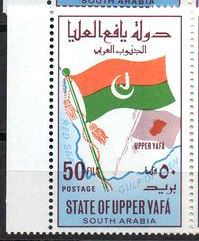
Upper Yafa
Upper Yafa or Upper Yafa'i ( ''),'' officially the State of Upper Yafa ( '')'', was a military alliance in the British Aden Protectorate and the Protectorate of South Arabia. It was ruled by the Harharah dynasty and its capital was Mahjaba, a small town on a hill located about 50km northeast of Habilayn. Upper Yafa was one part of Yafa'a, the other part being Lower Yafa. The sultan of Upper Yafa had very little control over Upper Yafa's constituent sheikdoms, which had separate protectorate treaties with the British, and were free to disassociate from the policies of the Upper Yafa sheikh. The only time that the Upper Yafa sheikh held influence was during a crisis that threatened the independence of Upper Yafa's states, during which they would unite under the sultan. This meant that Upper Yafa was more akin to a military alliance than a genuine state. History The Yafa'i tribe has traditionally inhabited the mountainous hinterland of the Aden area. Upper Yafa was formed ... [...More Info...] [...Related Items...] OR: [Wikipedia] [Google] [Baidu] |
Mawsata
Mawsata, Mausata (), or the Mawsata State ( '), was a state in the British Aden Protectorate. Mawsata was located in the western and southwestern part of Upper Yafa. The main mountain in the area is Jabal Darfan. Mawsata was the most populated of the five sheikhdoms of Upper Yafa. The last ruler was deposed in 1967 upon the founding of the People's Republic of South Yemen and the area is now part of the Republic of Yemen. History The State of Mawsata (Dawlat Mawsata) was established in 1780. Owing to family dissensions, in 1860 the ruling family was divided into two lineages. Around 1904 the state became a British protectorate. Mawsata was part of the Protectorate of South Arabia until 1967 when it was abolished. Rulers The ruler of Mawsata State bore the title '' Naqib''. *1780 - 1810 al-Qasim Al Harhara *1810 - 1840 `Ali ibn al-Qasim Al Harhara *1840 - 1860 `Askar ibn `Ali Al Harhara Lineage 1 *1860 - 1907 `Al ... [...More Info...] [...Related Items...] OR: [Wikipedia] [Google] [Baidu] |
Na'wah (Upper Yafa)
Na'wah or Nawa (Arabic: نعوة) was a sheikhdom and dependency of Upper Yafa. It was a section of the Mawsata. History Na'wah was a dependency of Upper Yafa. It was placed within the British sphere of influence in the Anglo-Ottoman Convention of 1914. However, it never signed a protectorate treaty with Britain. In 1908, Britain fined Na'wah $1200 for aggression against Al-Dhubi. In February 1915, during World War I, one of the sheikhs of Na'wah submitted to the Ottomans, although another refused to comply with the Ottoman summons. It was annexed by the Mutawakkilite Kingdom of Yemen after the end of World War I, alongside Rubeaten (another Upper Yafa dependency) and later the Beda Sultanate. Geography Na'wah laid on the frontier between Ottoman and British Yemen, to the north-east of Qa'tabah, and on the left bank of the Wadi Bana. It contained several villages and hamlets. One village, located 5 miles (8 km) from Wadi Bana, was called Na'wah. Another village under the N ... [...More Info...] [...Related Items...] OR: [Wikipedia] [Google] [Baidu] |
