|
Iset (river)
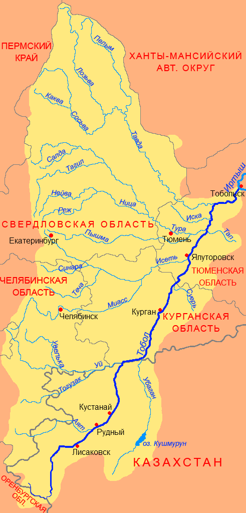
The river Iset () in Russia flows from the Urals through the Sverdlovsk and Kurgan Oblasts, then through Tyumen Oblast in Western Siberia into the river Tobol. The city of Yekaterinburg is on the upper part of the river. The Iset is long, and has a drainage basin A drainage basin is an area of land in which all flowing surface water converges to a single point, such as a river mouth, or flows into another body of water, such as a lake or ocean. A basin is separated from adjacent basins by a perimeter, ... of . The Techa and the Miass are tributaries of the Iset. References Rivers of Sverdlovsk Oblast {{Russia-river-stub ... [...More Info...] [...Related Items...] OR: [Wikipedia] [Google] [Baidu] |
Yekaterinburg
Yekaterinburg (, ; ), alternatively Romanization of Russian, romanized as Ekaterinburg and formerly known as Sverdlovsk ( ; 1924–1991), is a city and the administrative centre of Sverdlovsk Oblast and the Ural Federal District, Russia. The city is located on the Iset River between the Idel-Ural, Volga-Ural region and Siberia, with a population of roughly 1.5 million residents, up to 2.2 million residents in the urban agglomeration. Yekaterinburg is the list of cities and towns in Russia by population, fourth-largest city in Russia, the largest city in the Ural Federal District, and one of Russia's main cultural and industrial centres. Yekaterinburg has been dubbed the "Third capital of Russia", as it is ranked third by the size of its economy, culture, transportation and tourism. Yekaterinburg was founded on 18 November 1723 and named after the Orthodox name of Catherine I of Russia, Catherine I (born Marta Helena Skowrońska), the wife of Russian Emperor Peter the G ... [...More Info...] [...Related Items...] OR: [Wikipedia] [Google] [Baidu] |
Lake Iset
Lake Iset () is a sweet water lake in Sverdlovsk Oblast, 25 km north-west from the city of Yekaterinburg, on the shore of the lake stands the city Sredneuralsk. It has an area of about 24 km2. Into the lake many rivers and streams flow, Shitovskoy source, Big Black, Kalynivka, Beryozovka Lebyazhka and Mulyanka. One follows the Iset River. The lake is surrounded by mountains. Several small islands: Solovetsky reds (because of its shape was formerly called "Cap of Monomakh"), Stone (formerly called "The Ship"). At the lakeshore settlements: Sredneuralsk city, village Iset, villages and Koptyaki Murzinka. Iset lake is rich in fish, including rudd, bream, tench, ruff, perch and pike. Acclimatized species such as carp and mirror carp. In 1850 in the mouth of the river Iset began construction of an earthen dam. Only in 1946 was replaced by an earthen dam on the concrete. Due to this, the lake level rose to the current level. The lake water is used in Sredneuralskaya. On the sho ... [...More Info...] [...Related Items...] OR: [Wikipedia] [Google] [Baidu] |
Tobol
The Tobol (, ) is a river in Western Siberia (in Kazakhstan and Russia) and the main (left) tributary of the Irtysh. Its length is , and the area of its drainage basin is . History The Tobol River was one of the four important rivers of the Siberia Khanate. In 1428 the khan was killed in a battle with the forces of Abu'l-Khayr Khan at the Battle of Tobol. In the 16th century, the Tobol was the eastern terminus of the portage route leading westward to the rivers Vishera and Kama. Cities and towns on the Tobol * Lisakovsk in Kazakhstan * Rudni in Kazakhstan * Kostanay (formerly Nikolaevsk) in Kazakhstan * Kurgan in the Russian Federation * Yalutorovsk in the Russian Federation * Tobolsk in the Russian Federation, where the Tobol joins the Irtysh Main tributaries The largest tributaries of the Tobol are, from source to mouth: * Syntasty (left) * Ayat (left) * Uy (left) * Ubagan (right) * Iset (left) * Tura (left) * Tavda (left) References Rivers of Ka ... [...More Info...] [...Related Items...] OR: [Wikipedia] [Google] [Baidu] |
Russia
Russia, or the Russian Federation, is a country spanning Eastern Europe and North Asia. It is the list of countries and dependencies by area, largest country in the world, and extends across Time in Russia, eleven time zones, sharing Borders of Russia, land borders with fourteen countries. Russia is the List of European countries by population, most populous country in Europe and the List of countries and dependencies by population, ninth-most populous country in the world. It is a Urbanization by sovereign state, highly urbanised country, with sixteen of its urban areas having more than 1 million inhabitants. Moscow, the List of metropolitan areas in Europe, most populous metropolitan area in Europe, is the capital and List of cities and towns in Russia by population, largest city of Russia, while Saint Petersburg is its second-largest city and Society and culture in Saint Petersburg, cultural centre. Human settlement on the territory of modern Russia dates back to the ... [...More Info...] [...Related Items...] OR: [Wikipedia] [Google] [Baidu] |
Techa
The Techa (, ) is an eastward river on the eastern flank of the southern Ural Mountains noted for its nuclear contamination. It is long, and its basin covers . It begins by the once-secret nuclear processing town of Ozyorsk about northwest of Chelyabinsk and flows east then northeast to the small town of Dalmatovo to flow into the mid-part of the Iset, a tributary of the Tobol. Its basin is close to and north of the Miass, longer than these rivers apart from the Tobol. Water pollution From 1949 to 1956 the Mayak complex dumped an estimated of water into the Techa River, [...More Info...] [...Related Items...] OR: [Wikipedia] [Google] [Baidu] |
Miass (river)
The Miass (, ''Meyäs'') is a river on the eastern side of the Ural Mountains in Bashkortostan, Chelyabinsk Oblast and Kurgan Oblast, Russia. It is a right tributary of the Iset, part of the Irtysh basin.Миасс (река в Челябинской и Курганской областях) It is long, and has a of . The cities |
Urals
The Ural Mountains ( ),; , ; , or simply the Urals, are a mountain range in Eurasia that runs north–south mostly through Russia, from the coast of the Arctic Ocean to the river Ural (river), Ural and northwestern Kazakhstan.Ural Mountains , Encyclopædia Britannica on-line The mountain range forms part of the Boundaries between the continents of Earth, conventional boundary between the continents of Europe and Asia, marking the separation between European Russia and Siberia. Vaygach Island and the islands of Novaya Zemlya form a further continuation of the chain to the north into the Arctic Ocean. The average altitudes of the Urals are around , the highest point being Mount Narodnaya, which reaches a height of . The mountains lie within the Ural (region), Ural geographical region and significantl ... [...More Info...] [...Related Items...] OR: [Wikipedia] [Google] [Baidu] |
Sverdlovsk Oblast
Sverdlovsk Oblast ( rus, Свердловская область, Sverdlovskaya oblastʹ, p=svʲɪrdˈlofskəjə ˈobləsʲtʲ) is a federal subject (an oblast) of Russia located in the Ural Federal District. Its administrative center is the city of Yekaterinburg, formerly known as "Sverdlovsk". Its population is 4,268,998 (according to the 2021 Census). Geography Most of the oblast is spread over the eastern slopes of the Middle and North Urals and the Western Siberian Plain. Only in the southwest does the oblast stretch onto the western slopes of the Ural Mountains. The highest mountains all rise in the North Urals, Konzhakovsky Kamen at and Denezhkin Kamen at . The Middle Urals is mostly hilly country with no discernible peaks; the mean elevation is closer to above sea level. Principal rivers include the Tavda, the Tura, the Chusovaya, and the Ufa, the latter two being tributaries of the Kama. Sverdlovsk Oblast borders with, clockwise from the west, Perm Krai, th ... [...More Info...] [...Related Items...] OR: [Wikipedia] [Google] [Baidu] |
Kurgan Oblast
Kurgan Oblast () is a federal subject of Russia (an oblast). Its administrative center is the city of Kurgan. According to the 2021 Census, the population was 776,661, down from 910,807 recorded in the 2010 Census. History Formed by Decree of the Presidium of the Supreme Soviet of the USSR of February 6, 1943. The region included 32 districts of the eastern part of the Chelyabinsk region and 4 districts of the Omsk region with a total population of 975,000. Recipient of the Order of Lenin (1959). Geography Kurgan Oblast is located in Southern Russia and is part of the Urals Federal District. It shares borders with Chelyabinsk Oblast to the west, Sverdlovsk Oblast to the north-west, Tyumen Oblast to the north-east, and Kazakhstan ( Kostanay and North Kazakhstan Region) to the south. Lakes Medvezhye and Filatovo are located in the district. Climate The oblast has a severe continental climate with long cold winters and warm summers with regular droughts. The average ... [...More Info...] [...Related Items...] OR: [Wikipedia] [Google] [Baidu] |
Tyumen Oblast
Tyumen Oblast () is a federal subjects of Russia, federal subject (an oblast) of Russia. It is located in Western Siberia, and is administratively part of the Ural Federal District. The oblast has administrative jurisdiction over two autonomous okrugs of Russia, autonomous okrugs: the Khanty-Mansi Autonomous Okrug, Khanty-Mansi and Yamalo-Nenets Autonomous Okrug. The oblast, including its autonomous okrugs, is the third-largest federal subject by area, and has a population of 3,395,755 (Russian Census (2010), 2010). (The rank is given without the autonomous okrugs' populations; the population and percentages are given for the territory of the oblast with the autonomous okrugs) Tyumen is the largest types of inhabited localities in Russia, city and the Administrative centre, administrative center of the oblast, and the first Russian settlement east of the Ural Mountains. Tyumen Oblast is the largest producer of oil and natural gas in the country, and has experienced an oil boom ... [...More Info...] [...Related Items...] OR: [Wikipedia] [Google] [Baidu] |
Drainage Basin
A drainage basin is an area of land in which all flowing surface water converges to a single point, such as a river mouth, or flows into another body of water, such as a lake or ocean. A basin is separated from adjacent basins by a perimeter, the drainage divide, made up of a succession of elevated features, such as ridges and hills. A basin may consist of smaller basins that merge at river confluences, forming a hierarchical pattern. Other terms for a drainage basin are catchment area, catchment basin, drainage area, river basin, water basin, and impluvium. In North America, they are commonly called a watershed, though in other English-speaking places, " watershed" is used only in its original sense, that of the drainage divide line. A drainage basin's boundaries are determined by watershed delineation, a common task in environmental engineering and science. In a closed drainage basin, or endorheic basin, rather than flowing to the ocean, water converges toward the ... [...More Info...] [...Related Items...] OR: [Wikipedia] [Google] [Baidu] |


