|
Hörnum
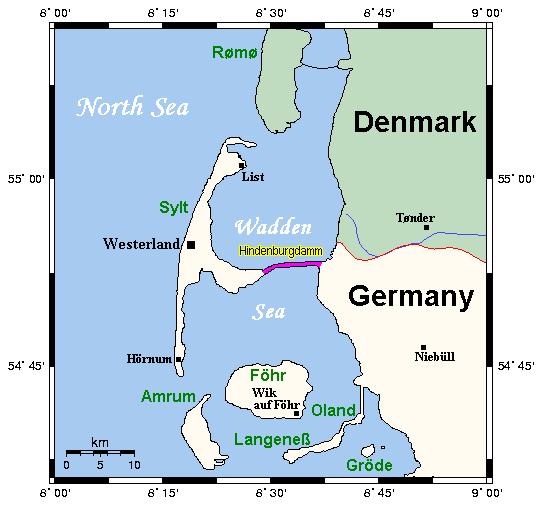
( Sölring Frisian: ''Hörnem'', Danish: ''Hørnum'') is a municipality in the district of Nordfriesland, in Schleswig-Holstein, Germany. It is located on the southern headland of the island of Sylt. The municipality is part of the '' Amt'' Landschaft Sylt. The economy is dominated by tourism. Etymology Hörnum's name is derived from ''Hörn'' ("corner" or "edge"). Geography Hörnum is located on the southern tip of Sylt. Most of the municipal territory is covered by nature reserves (mostly dunes and heath). The ''Hörnum Odde'' is the southernmost point of the island and subject to constant erosion by wind and sea. History First settlements Although fishermen had reportedly settled in the area prior to 1500 AD, the place is first recorded in 1649 as ''Hornum''. The name "Hörnum" was already known to the chronicler Muchel-Madis (* 11 November 1572 in Morsum; † 21 January 1651), who in his chronicles reports a shipwrecking "1571... off Hörnum". In 1648, the area was ... [...More Info...] [...Related Items...] OR: [Wikipedia] [Google] [Baidu] |
Sylt
Sylt (; ; Söl'ring North Frisian: ) is an island in northern Germany, part of Nordfriesland district, Schleswig-Holstein, with a distinctively shaped shoreline. It belongs to the North Frisian Islands and is the largest island in North Frisia. The northernmost island of Germany, it is known for its tourist resorts, notably Westerland, Kampen and Wenningstedt-Braderup, as well as for its sandy beach. It is frequently covered by the media in connection with its exposed situation in the North Sea and its ongoing loss of land during storm tides. Since 1927, Sylt has been connected to the mainland by the Hindenburgdamm causeway. In later years, it has been a resort for the German jet set and tourists in search of occasional celebrity sightings. Geography With , Sylt is the fourth-largest German island and the largest German island in the North Sea. Sylt is located from off the mainland, to which it is connected by the Hindenburgdamm. Southeast of Sylt are the islands ... [...More Info...] [...Related Items...] OR: [Wikipedia] [Google] [Baidu] |
Westerland, Germany
Westerland (; ; Söl'ring, ''Söl'ring'' North Frisian: ''Weesterlön’'') is a Resort town, seaside resort and a former municipality located on the Germany, German North Sea island of Sylt. Since 1 January 2009, Westerland has been part of the municipality ''Sylt (municipality), Gemeinde Sylt''. Westerland is part of the Nordfriesland district in Schleswig-Holstein. It is the largest resort on the island, the local transportation hub and the centre of Sylt's tourist industry. History Westerland is partly one of the younger settlements on the island of Sylt. After the All Saints' Day Flood of 1436 had destroyed the biggest part of the community of Eidum (except for the area that is today called ''Enden and the Church''), the survivors built a new community to the northeast on a Heath (habitat), heath. The new settlement was called ''Hedigen'' (heath area). In the 16th. century most of the people on Sylt were involved in the hunting of Herring near Heligoland, Westerland was no ... [...More Info...] [...Related Items...] OR: [Wikipedia] [Google] [Baidu] |
Nordfriesland
Nordfriesland (; ; Low German: Noordfreesland), also known as North Frisia, is the northernmost Districts of Germany, district of Germany, part of the state of Schleswig-Holstein. It includes almost all of traditional North Frisia (with the exception of the island of Heligoland), as well as adjacent parts of the Schleswig Geest to the east and Stapelholm to the south, and is bounded (from the east and clockwise) by the districts of Schleswig-Flensburg and Dithmarschen, the North Sea and the Denmark, Danish county of South Jutland County, South Jutland. The district is called ''Kreis Nordfriesland'' in German language, German, ''Kreis Noordfreesland'' in Low German language, Low German, ''Kris Nordfraschlönj'' in Mooring (North Frisian dialect), Mooring North Frisian, ''Kreis Nuurdfresklun'' in Fering, Fering North Frisian and ''Nordfrislands amt'' in Danish language, Danish. As of 2008, Nordfriesland was the Tourism in Germany, most visited rural district in Germany. Histor ... [...More Info...] [...Related Items...] OR: [Wikipedia] [Google] [Baidu] |
Rantum
Rantum (; Sölring Frisian: Raantem) is a village and a former municipality on the island of Sylt in the district of Nordfriesland, in Schleswig-Holstein, Germany. Since 1 January 2009, it has been an ''Ortsteil'' (part) of the municipality Sylt. Etymology The name is frequently associated with the marine goddess Rán (''Rantum'' = Rán's place). It is, however, more likely that the name derives from the old spelling of ''Raantem'', i.e. "settlement at the edge". Geography Rantum today is located at the narrowest part of the island with a width of only 600 metres. East of the village are the ''Rantum-Inge'', an ample area of salt marshes and the Wadden Sea. To the west, beyond the dunes, the beach faces the open North Sea. History The small village of Rantum has a colourful history. The settlement was destroyed on multiple occasions by storm surges or was buried by sand drift. The oldest record of the name is found in a nautical chart from 1142, which is today disp ... [...More Info...] [...Related Items...] OR: [Wikipedia] [Google] [Baidu] |
Amrum
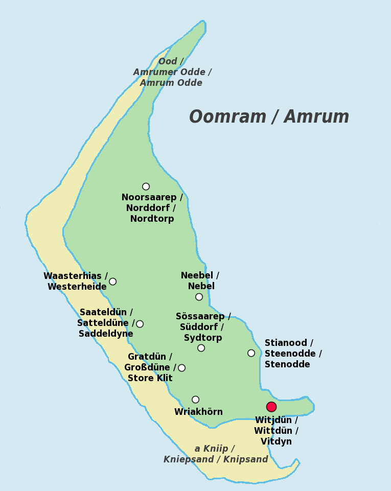
Amrum (; Öömrang, ''Öömrang'' North Frisian: ''Oomram'') is one of the North Frisian Islands on the Germany, German North Sea coast, south of Sylt and west of Föhr. It is part of the Nordfriesland district in the federal state of Schleswig-Holstein and has approximately 2,300 inhabitants. The island is made up of a sandy core of geestland and features an extended beach all along its west coast, facing the open North Sea. The east coast borders to mudflats of the Wadden Sea. Sand dunes are a characteristic part of Amrum's landscape, resulting in a vegetation that is largely made up of heath and shrubs. The island's only forest was planted in 1948. Amrum is a refuge for many species of birds and a number of marine mammals including the grey seal and harbour porpoise. Settlements on Amrum have been traced back to the Neolithic period when the area was still a part of the mainland of the Jutland peninsula. During the Middle Ages, Frisians, Frisian settlers arrived at Amrum and e ... [...More Info...] [...Related Items...] OR: [Wikipedia] [Google] [Baidu] |
Landschaft Sylt
Landschaft Sylt is an ''Amt (administrative division), Amt'' ("collective municipality") in the district of Nordfriesland, in Schleswig-Holstein, Germany. It covers the island of Sylt (except the independent municipality Sylt (municipality), Sylt in the center of the island), in the North Sea, about 65 km northwest of Husum, Germany, Husum. Its administrative seat is in the town Westerland, Germany, Westerland - which is not, however, a part of the ''Amt''. Subdivision The ''Amt'' Landschaft Sylt consists of the following municipalities: #Hörnum #Kampen, Germany, Kampen #List, Schleswig-Holstein, List #Wenningstedt-Braderup Note: The total number of inhabitants, under 4,500, is less than the minimum requirement for an independently administrated ''Amt'' (8,000 inhabitants). The administration of the ''Amt'' is thus shared with the ''Sylt (municipality), Gemeinde Sylt''. Since 2009, the seat of the ''Amt'' has been located in the townhall of the ''Gemeinde Sylt'' in Westerl ... [...More Info...] [...Related Items...] OR: [Wikipedia] [Google] [Baidu] |
Westerhever
Westerhever () is a municipality in Nordfriesland in the German state of Schleswig-Holstein. Geography Westerhever lies on the northwestern tip of the Eiderstedt Peninsula. The Westerheversand Lighthouse is a major landmark on the peninsula which is surrounded by salt marshes. The saltmarshes, lighthouse, and beaches A beach is a landform alongside a body of water which consists of loose particles. The particles composing a beach are typically made from Rock (geology), rock, such as sand, gravel, shingle beach, shingle, pebbles, etc., or biological s ... attract about 80,000 visitors every year. History The island Westerhever was first settled by humans in the 12th Century. The first humans there built a ring dike to protect the land. References External links Municipalities in Schleswig-Holstein Nordfriesland {{SchleswigHolstein-geo-stub ... [...More Info...] [...Related Items...] OR: [Wikipedia] [Google] [Baidu] |
Hindenburg Causeway
The Hindenburgdamm or Hindenburg Dam is an 11 km (7 mile) long causeway joining the North Frisian island of Sylt Sylt (; ; Söl'ring North Frisian: ) is an island in northern Germany, part of Nordfriesland district, Schleswig-Holstein, with a distinctively shaped shoreline. It belongs to the North Frisian Islands and is the largest island in North Fris ... to mainland Schleswig-Holstein. Its coordinates are . It was opened on 1 June 1927 and is exclusively a railway corridor. The companies that built the Hindenburgdamm, a job that took four years, were Philipp Holzmann AG of Frankfurt, working from the mainland, and Peter Fix Söhne of Duisburg working from Sylt. A train trip along the causeway takes about 10 minutes, and the time between the auto terminals at Niebüll on the mainland and Westerland (Schleswig), Westerland on Sylt is about 30 minutes. The Hindenburgdamm is part of the railway line known as the ''Marschbahn'' ("Marsh Railway"), which is Double track ... [...More Info...] [...Related Items...] OR: [Wikipedia] [Google] [Baidu] |


