|
Hetao Plain
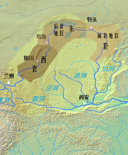
Hetao () is a C-shaped region in northwestern China consisting of a collection of flood plains stretching from the banks of the northern half of the Ordos Loop, a large northerly rectangular bend of the Yellow River, that forms the river's entire middle section. The region makes up the northern margin of the Ordos Basin, bounded in the west by the Helan Mountains, the north by the Yin Mountains, the east by the northern portion of Lüliang Mountains, and the south by the Ordos Desert and the Loess Plateau (separated by the course of the Ming Great Wall). The Hetao region is divided into two main sections — the "West Loop" () in Ningxia, and the "East Loop" () in Inner Mongolia. The west section includes the alluvial Yinchuan Plain (, a.k.a. Ningxia Plain) around Shizuishan, Yinchuan, and Wuzhong, and the Weining Plain () around Zhongwei. The east section is further divided into two parts — the western "Back Loop" (), which includes the Bayannur Plain () around Bayannur ... [...More Info...] [...Related Items...] OR: [Wikipedia] [Google] [Baidu] |
Alluvial Plain
An alluvial plain is a plain (an essentially flat landform) created by the deposition of sediment over a long period by one or more rivers coming from highland regions, from which alluvial soil forms. A ''floodplain'' is part of the process, being the smaller area over which the rivers flood at a particular time. In contrast, the alluvial plain is the larger area representing the region over which the floodplains have shifted over geological time. As the highlands erode due to weathering and water flow, the sediment from the hills is transported to the lower plain. Various creeks will carry the water further to a river, lake, bay, or ocean. As the sediments are deposited during flood conditions in the floodplain of a creek, the elevation of the floodplain will be raised. As this reduces the channel floodwater capacity, the creek will, over time, seek new, lower paths, forming a meander (a curved path). The leftover higher locations, typically natural levees at the margins of ... [...More Info...] [...Related Items...] OR: [Wikipedia] [Google] [Baidu] |
Agricultural
Agriculture encompasses crop and livestock production, aquaculture, and forestry for food and non-food products. Agriculture was a key factor in the rise of sedentary human civilization, whereby farming of domesticated species created food surpluses that enabled people to live in the cities. While humans started gathering grains at least 105,000 years ago, nascent farmers only began planting them around 11,500 years ago. Sheep, goats, pigs, and cattle were domesticated around 10,000 years ago. Plants were independently cultivated in at least 11 regions of the world. In the 20th century, industrial agriculture based on large-scale monocultures came to dominate agricultural output. , small farms produce about one-third of the world's food, but large farms are prevalent. The largest 1% of farms in the world are greater than and operate more than 70% of the world's farmland. Nearly 40% of agricultural land is found on farms larger than . However, five of every six farms ... [...More Info...] [...Related Items...] OR: [Wikipedia] [Google] [Baidu] |
Pastoralism
Pastoralism is a form of animal husbandry where domesticated animals (known as "livestock") are released onto large vegetated outdoor lands (pastures) for grazing, historically by nomadic people who moved around with their herds. The animal species involved include cattle, camels, goats, yaks, llamas, reindeer, horses, and sheep. Pastoralism occurs in many variations throughout the world, generally where environmentally effected characteristics such as aridity, poor soils, cold or hot temperatures, and lack of water make crop-growing difficult or impossible. Operating in more extreme environments with more marginal lands means that pastoral communities are very vulnerable to the effects of global warming. Pastoralism remains a way of life in many geographic areas, including Africa, the Tibetan plateau, the Eurasian steppes, the Andes, Patagonia, the Pampas, Australia and many other places. , between 200 million and 500 million people globally practiced pa ... [...More Info...] [...Related Items...] OR: [Wikipedia] [Google] [Baidu] |
Grassland
A grassland is an area where the vegetation is dominance (ecology), dominated by grasses (Poaceae). However, sedge (Cyperaceae) and rush (Juncaceae) can also be found along with variable proportions of legumes such as clover, and other Herbaceous plant, herbs. Grasslands occur naturally on all continents except Antarctica and are found in most ecoregions of the Earth. Furthermore, grasslands are one of the largest biomes on Earth and dominate the landscape worldwide. There are different types of grasslands: natural grasslands, semi-natural grasslands, and agricultural grasslands. They cover 31–69% of the Earth's land area. Definitions Included among the variety of definitions for grasslands are: * "...any plant community, including harvested forages, in which grasses and/or legumes make up the dominant vegetation." * "...terrestrial ecosystems dominated by herbaceous and shrub vegetation, and maintained by fire, grazing, drought and/or freezing temperatures." (Pilot Assessm ... [...More Info...] [...Related Items...] OR: [Wikipedia] [Google] [Baidu] |
Steppe
In physical geography, a steppe () is an ecoregion characterized by grassland plains without closed forests except near rivers and lakes. Steppe biomes may include: * the montane grasslands and shrublands biome * the tropical and subtropical grasslands, savannas, and shrublands biome * the temperate grasslands, savannas, and shrublands biome A steppe is usually covered with grass and shrubs, depending on the season and latitude. The term ''steppe climate'' denotes a semi-arid climate, which is encountered in regions too dry to support a forest, but not dry enough to be a desert. Steppes are usually characterized by a semi-arid or continental climate. Temperature extremes can be recorded in the summer of up to and in winter of down to . Besides this major seasonal difference, fluctuations between day and night are also significant: in both the highlands of Mongolia and northern Nevada, can be reached during the day with sub-freezing readings at night. Steppes ave ... [...More Info...] [...Related Items...] OR: [Wikipedia] [Google] [Baidu] |
Desert
A desert is a landscape where little precipitation occurs and, consequently, living conditions create unique biomes and ecosystems. The lack of vegetation exposes the unprotected surface of the ground to denudation. About one-third of the land surface of the Earth is arid or Semi-arid climate, semi-arid. This includes much of the Polar regions of Earth, polar regions, where little precipitation occurs, and which are sometimes called polar deserts or "cold deserts". Deserts can be classified by the amount of precipitation that falls, by the temperature that prevails, by the causes of desertification or by their geographical location. Deserts are formed by weathering processes as large variations in temperature between day and night strain the Rock (geology), rocks, which consequently break in pieces. Although rain seldom occurs in deserts, there are occasional downpours that can result in flash floods. Rain falling on hot rocks can cause them to shatter, and the resulting frag ... [...More Info...] [...Related Items...] OR: [Wikipedia] [Google] [Baidu] |
Hohhot
Hohhot,; abbreviated zh, c=呼市, p=Hūshì, labels=no formerly known as Kweisui, is the Capital (political), capital of Inner Mongolia in the North China, north of the China, People's Republic of China, serving as the region's administrative, economic and cultural center.''The New Encyclopædia Britannica'', 15th Edition (1977), Volume I, p. 275. Its population was 3,446,100 inhabitants as of the 2020 census, of whom 2,944,889 lived in the metropolitan area consisting of 4 urban districts (including Hohhot Economic and Development Zone) plus the Tumed Left Banner. The name of the city in Mongolian means "Blue City", although it is also wrongly referred to as the "Green City."Perkins (1999), p. 212. The color blue in Mongol culture is associated with the sky, eternity and purity. In Chinese, the name can be translated as ''Qīng Chéng'' ( zh, c=青城 , l=Distinguishing blue from green in language#Chinese, Blue/Green City) The name has also been variously romanized as Kokota ... [...More Info...] [...Related Items...] OR: [Wikipedia] [Google] [Baidu] |
Baotou
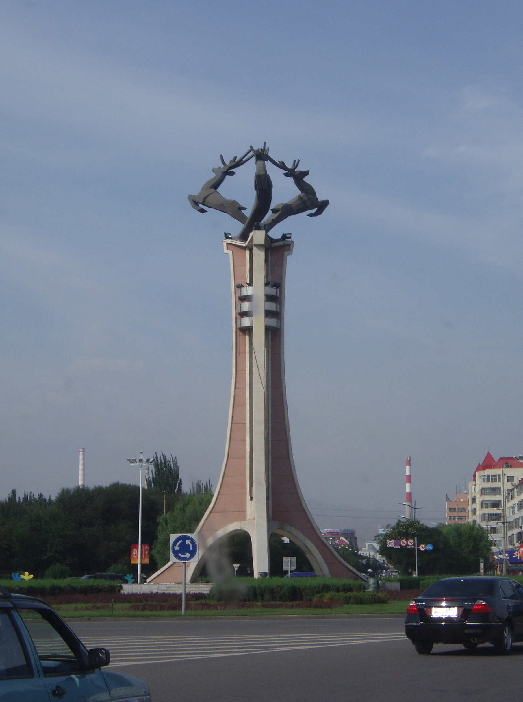
Baotou; is the largest city by urban population in Inner Mongolia, China. Governed as a prefecture-level city, as of the 2020 census, its built-up (''or metro'') area made up of its 5 urban districts is home to 2,261,089 people with a total population of 2,709,378 accounting for counties under its jurisdiction. The city's namesake, literally translated to "place with deer", is of Mongolic origin or "Lucheng" ( zh, c=鹿城 , p=Lùchéng), meaning "City of Deer". Alternatively Baotou is known as the "City of Steel in Gobi" ( zh, labels=no, s=草原钢城 , p=Cǎoyuán Gāngchéng). Steel was a major industry in the city. Today, Baotou refines over half of the rare-earth minerals produced in the world. This has led to environmental contamination near the industrial sites. History Ancient times The area now known as Baotou was inhabited by nomads, some of whose descendants would later be categorized as Mongols. Near the end of the Han dynasty (206 BC–220 AD), Lü Bu, a partic ... [...More Info...] [...Related Items...] OR: [Wikipedia] [Google] [Baidu] |
Wuhai
Wuhai (; ''Üqai qota'', Mongolian Cyrillic: Үхай хот) is a prefecture-level city and regional center in the Inner Mongolia Autonomous Region, China, and is by area the smallest prefecture-level division of the region. It is located on the Yellow River between the Gobi and Ordos deserts. Wuhai became a single city occupying both banks of the Yellow River with the amalgamation in 1976 of Wuda on the left (west) bank (then administrated by Bayan Nuur League) together with Haibowan on the right (east) bank (then administrated by Ikh Juu league). Wuhai is one of very few cities with an antipode which is not only on land (as opposed to open ocean), but which is another inhabited city; the antipode of Wuhai is almost exactly on the city of Valdivia, Chile. Football commentator and Television host Huang Jianxiang is born here. History The modern location of Wuhai was originally composed of two towns: Wuda which lied on the western side of the Yellow River and Haibowa ... [...More Info...] [...Related Items...] OR: [Wikipedia] [Google] [Baidu] |
Bayannur
Bayannur or Bayannao'er ( zh, c=巴彦淖尔市, p=bāyànnàoěr; ''Bayannaɣur qota'', Mongolian Cyrillic Баяннуур хот) is a prefecture-level city in western Inner Mongolia, People's Republic of China. Until 1 December 2003, the area was called Bayannur League. Bayannur has an administrative area of . The name of the city in Mongolian means "Rich Lake". As of the 2010 census, the population of Bayannur was 1,669,915; while the city proper, Linhe District, had 520,300 inhabitants. The city is served by the Bayannur Tianjitai Airport. History The Zhao dynasty (403 BCE–222 BCE) controlled an area including modern-day Bayannur, while the Western Han dynasty (206 BCE–24 CE) established a hierarchical Chinese administrative structure. The Qing dynasty (1644–1912) designated this area as part of "Inner Mongolia", but after its overthrow by the Republic of China (1912–1949), Bayannur was assigned to Suiyuan Province. Because of Mongol-Chinese cooperation wit ... [...More Info...] [...Related Items...] OR: [Wikipedia] [Google] [Baidu] |
Zhongwei
Zhongwei (, Xiao'erjing: جْووِ شِ) is a prefecture-level city of Ningxia, People's Republic of China. It has an area of and a population of 1,174,600 in 2019. The city is known for its wolfberry and Gobi watermelon cultivation. One of the world's largest photovoltaic power station, Tengger Desert Solar Park, is located in Zhongwei. History Under general Meng Tian, the Qin captured the area of Zhongwei and established the Beidi Commandery. In 205 BC a city built at the current location of Zhongwei urban area, which would grow as irrigation systems were built to allow farming. In 1226 Genghis Khan captured Zhongwei, and in 1403 the city was named Zhongwei, part of Shaanxi. In 1920 Zhongwei was struck by the Haiyuan earthquake; and in 1926 the highway from Lanzhou to Zhongwei opened. Tourism Zhongwei's main attraction is Gao Miao, a temple that has hosted Confucian, Buddhist, and Taoist ceremonies. A bomb shelter was also built beneath the temple during the Cultural ... [...More Info...] [...Related Items...] OR: [Wikipedia] [Google] [Baidu] |


