|
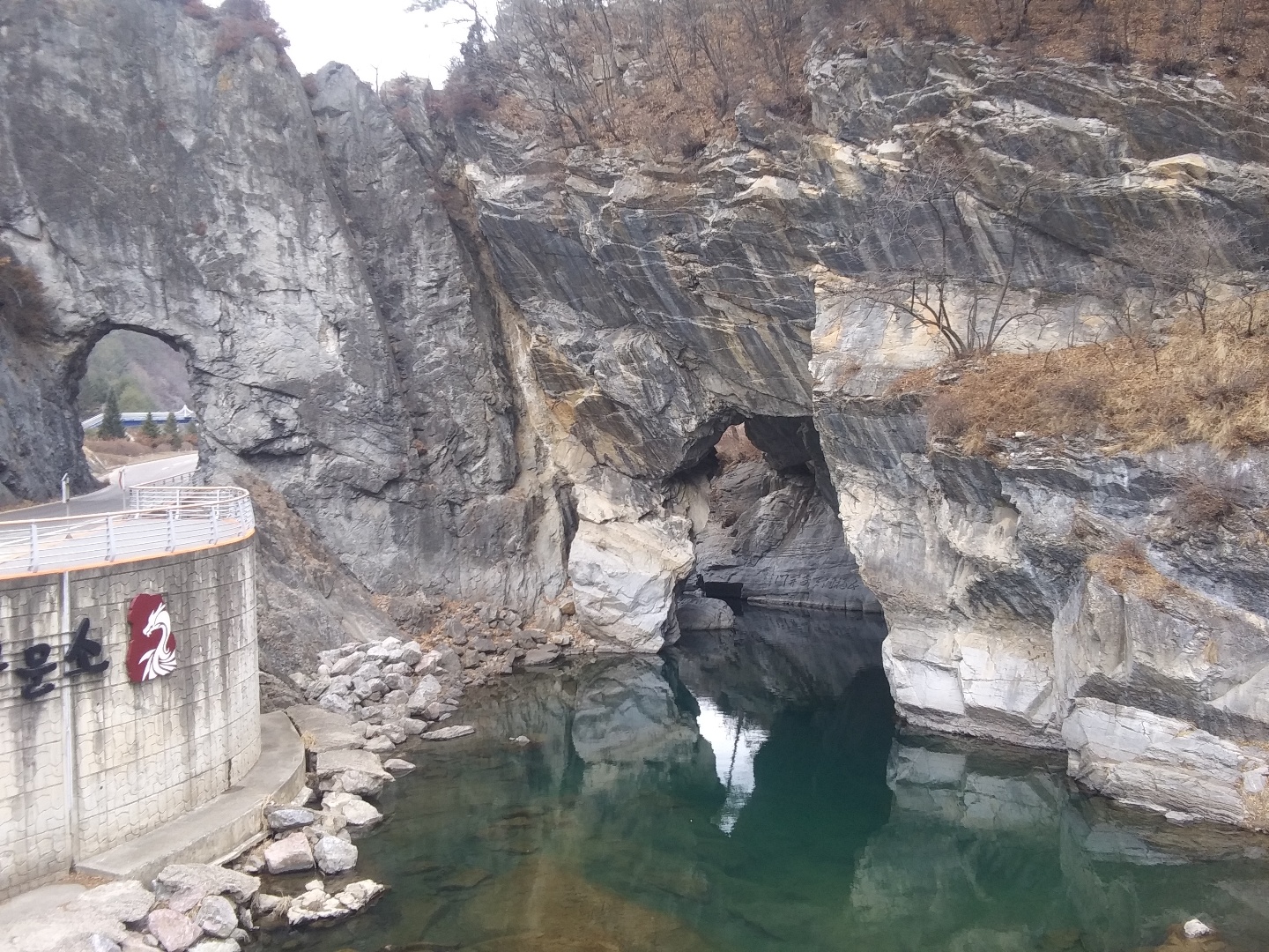
Gumunso
Gumunso () is a swamp in Dongjeom-dong, Taebaek, Gangwon Province, South Korea which features a river that pierces through a mountain, the only one of its kind in Korea. It is also known for its geological value, as its stratigraphic continuity is well-preserved. It names the surrounding village and neighborhood ( dong). With an area of 685,109 m2, the "Ordovician Deposits and Topography of Stream Erosion of Gumunso" is a part of Gangwon Paleozoic National Geopark and is the 417th Natural Monument of South Korea. In Gumunso, the Jigunsan and Makgol Formation (with the former unconformably overlying the latter) from the Lower Paleozoic Ordovician period (~440 to 500 million years ago) can be found. The two streams Cheoramcheon (철암천) and Hwangjicheon (황지천) meet in Gumunso, and could be considered the start of the Nakdong River. Name The name Gumunso is a Hanja version of the name Gumuso (), where " 구무" is a Middle Korean term for "hole". A purely native-K ... [...More Info...] [...Related Items...] OR: [Wikipedia] [Google] [Baidu] |
Hwangjicheon
Hwangjicheon () is a stream in Taebaek, South Korea and is a tributary of the upper end of the Nakdong River, the longest river in South Korea. It originates in Hwajeon-dong, Taebaek, Gangwon Province, with a maximum flow path length of 29.1 km, a maximum straight-line length of 27.8 km, and a drainage basin area of 204.1 km². The stream flows through Hwangji-dong, Mungok-dong, Jangseong-dong, and Dongjeom-dong, and ends at Gumunso, where it merges with Cheoramcheon (철암천) to begin the Nakdong River. The stream is home to many flora and fauna. A 2021 survey by Nakdonggang National Institute of Biological Resources identified 297 species of plants in Hwangjicheon. Near the stream are many abandoned lead, zinc, and coal mines, including Yeonhwa Mine, Hamtae Coal Mine, and Eoryong Mine. Their mine runoffs altogether pose a pollution risk, with reddish discolorations being observed in some parts of the stream. A 2019 survey showed that toxic run-offs from coal ... [...More Info...] [...Related Items...] OR: [Wikipedia] [Google] [Baidu] |
Nakdong River
The Nakdong River or Nakdonggang (, ) is the longest river in South Korea, which passes through the major cities of Daegu and Busan. It takes its name from its role as the eastern border of the Gaya confederacy during Three Kingdoms of Korea, Korea's Three Kingdoms Era. Geography The Nakdong River flows from the Taebaek Mountains to the South Sea or Korea Strait, which separates Korea from Japan. The river originates from the junction of the Cheoramcheon and Hwangjicheon streams in Dongjeom-dong, Taebaek, Gangwon Province, South Korea, Gangwon Province at Gumunso. From there to its River mouth, mouth it winds for about . The width of the river ranges from only a few metres in its upper reaches to several hundred metres towards its estuary. Major tributaries include the Yeong River, Yeong, Geumho River, Geumho, and Nam River (South Korea), Nam rivers. Together with its Tributary, tributaries, the Nakdonggang drains most of North Gyeongsang Province, North Gyeongsang and South Gyeo ... [...More Info...] [...Related Items...] OR: [Wikipedia] [Google] [Baidu] |
Taebaek
Taebaek (; ) is a city in Gangwon Province, South Korea. Its name is shared with that of the Taebaek Mountains. Situated at an elevation of , Taebaek is the second highest city in South Korea, after Pyeongchang. Etymology Taebaek in is derived from Taebaeksan, meaning "very bright." Attractions Manggyeongsa Temple in Hyeol-dong, at an elevation of 1,460 meters on the Taebaek Mountains, is a temple built to enshrine the statue of the Bodhisattva of wisdom. It was built by Jajang, a Silla Dynasty monk. The "Dragon Spring" at the entrance of the temple is known as the highest spring in Korea.Cin Woo Le"Simply stunning: 33 incredible Korean temples" ''CNN Go''. 10 February 2012. Retrieved 2012-04-12 Other attractions include Taebaek Coal Museum and 365 Safe Town. Gumunso is a famous natural landmarks in Taebaek. Climate Transportation * Taebaek station Sister cities * Helong, Jilin, China since August 29, 1995 * Baguio, Philippines since April 25, 2006 * Suzhou, Jiangsu ... [...More Info...] [...Related Items...] OR: [Wikipedia] [Google] [Baidu] |
Meander
A meander is one of a series of regular sinuous curves in the Channel (geography), channel of a river or other watercourse. It is produced as a watercourse erosion, erodes the sediments of an outer, concave bank (cut bank, cut bank or river cliff) and deposits sediments on an inner, convex bank which is typically a point bar. The result of this coupled erosion and sedimentation is the formation of a sinuous course as the channel migrates back and forth across the axis of a floodplain. The zone within which a meandering stream periodically shifts its channel is known as a meander belt. It typically ranges from 15 to 18 times the width of the channel. Over time, meanders migrate downstream, sometimes in such a short time as to create civil engineering challenges for local municipalities attempting to maintain stable roads and bridges.Neuendorf, K.K.E., J.P. Mehl Jr., and J.A. Jackson, J.A., eds. (2005) ''Glossary of Geology'' (5th ed.). Alexandria, Virginia, American Geological I ... [...More Info...] [...Related Items...] OR: [Wikipedia] [Google] [Baidu] |
Calathid
A pseudanthium (; : pseudanthia) is an inflorescence that resembles a flower. The word is sometimes used for other structures that are neither a true flower nor a true inflorescence. Examples of pseudanthia include flower heads, composite flowers, or capitula, which are special types of inflorescences in which anything from a small cluster to hundreds or sometimes thousands of flowers are grouped together to form a single flower-like structure. Pseudanthia take various forms. The real flowers (the florets) are generally small and often greatly reduced, but the pseudanthium itself can sometimes be quite large (as in the heads of some varieties of sunflower). Pseudanthia are characteristic of the daisy and sunflower family (Asteraceae), whose flowers are differentiated into ray flowers and disk flowers, unique to this family. The disk flowers in the center of the pseudanthium are actinomorphic and the corolla is fused into a tube. Flowers on the periphery are zygomorphic and the ... [...More Info...] [...Related Items...] OR: [Wikipedia] [Google] [Baidu] |
Stromatolites
Stromatolites ( ) or stromatoliths () are layered sedimentary formations ( microbialite) that are created mainly by photosynthetic microorganisms such as cyanobacteria, sulfate-reducing bacteria, and Pseudomonadota (formerly proteobacteria). These microorganisms produce adhesive compounds that cement sand and other rocky materials to form mineral " microbial mats". In turn, these mats build up layer by layer, growing gradually over time. This process generates the characteristic lamination of stromatolites, a feature that is hard to interpret, in terms of its temporal and environmental significance. Different styles of stromatolite lamination have been described, which can be studied through microscopic and mathematical methods. A stromatolite may grow to a meter or more. Fossilized stromatolites provide important records of some of the most ancient life. As of the Holocene, living forms are rare. Definition Stromatolites are layered, biochemical, accretionary structur ... [...More Info...] [...Related Items...] OR: [Wikipedia] [Google] [Baidu] |
Trilobite
Trilobites (; meaning "three-lobed entities") are extinction, extinct marine arthropods that form the class (biology), class Trilobita. One of the earliest groups of arthropods to appear in the fossil record, trilobites were among the most successful of all early animals, existing in oceans for almost 270million years, with over 22,000 species having been described. Because trilobites had wide diversity and an easily fossilized mineralised exoskeleton made of calcite, they left an extensive fossil record. The study of their fossils has facilitated important contributions to biostratigraphy, paleontology, evolution, evolutionary biology, and plate tectonics. Trilobites are placed within the clade Artiopoda, which includes many organisms that are morphologically similar to trilobites, but are largely unmineralised. The relationship of Artiopoda to other arthropods is uncertain. Trilobites evolved into many ecological niches; some moved over the seabed as predators, scavengers, or ... [...More Info...] [...Related Items...] OR: [Wikipedia] [Google] [Baidu] |
Sedimentary Rock
Sedimentary rocks are types of rock (geology), rock formed by the cementation (geology), cementation of sediments—i.e. particles made of minerals (geological detritus) or organic matter (biological detritus)—that have been accumulated or deposited at Earth's surface. Sedimentation is any process that causes these particles to settle in place. Geological detritus originates from weathering and erosion of existing rocks, or from the solidification of molten lava blobs erupted by volcanoes. The geological detritus is transported to the place of deposition by water, wind, ice or Mass wasting, mass movement, which are called agents of denudation. Biological detritus is formed by bodies and parts (mainly shells) of dead aquatic organisms, as well as their fecal mass, suspended in water and slowly piling up on the floor of water bodies (marine snow). Sedimentation may also occur when dissolved minerals precipitate from aqueous solution, water solution. The sedimentary rock cover of ... [...More Info...] [...Related Items...] OR: [Wikipedia] [Google] [Baidu] |
Ordovician
The Ordovician ( ) is a geologic period and System (geology), system, the second of six periods of the Paleozoic Era (geology), Era, and the second of twelve periods of the Phanerozoic Eon (geology), Eon. The Ordovician spans 41.6 million years from the end of the Cambrian Period Megaannum, Ma (million years ago) to the start of the Silurian Period Ma. The Ordovician, named after the Celtic Britons, Welsh tribe of the Ordovices, was defined by Charles Lapworth in 1879 to resolve a dispute between followers of Adam Sedgwick and Roderick Murchison, who were placing the same Rock (geology), rock beds in North Wales in the Cambrian and Silurian systems, respectively. Lapworth recognized that the fossil fauna in the disputed Stratum, strata were different from those of either the Cambrian or the Silurian systems, and placed them in a system of their own. The Ordovician received international approval in 1960 (forty years after Lapworth's death), when it was adopted as an official per ... [...More Info...] [...Related Items...] OR: [Wikipedia] [Google] [Baidu] |
Doopedia
''Doosan Encyclopedia'' () is a Korean-language encyclopedia published by Doosan Donga (). The encyclopedia is based on the ''Dong-A Color Encyclopedia'' (), which comprises 30 volumes and began to be published in 1982 by Dong-A Publishing (). Dong-A Publishing was merged into Doosan Donga, a subsidiary of Doosan Group, in February 1985. The ''Doosan Encyclopedia'' is a major encyclopedia in South Korea. Digital edition EnCyber The online version of the ''Doosan Encyclopedia'' was named EnCyber, which is a blend of two English words: ''Encyclopedia'' and ''Cyber''. The company has stated that, with the trademark, it aims to become a center of living knowledge. EnCyber provides free content to readers via South Korean portals such as Naver. Naver has risen to the top position in the search engine market of South Korea partially because of the popularity of EnCyber encyclopedia. When Naver exclusively contracted Doosan Doonga in 2003, the former paid multi billion won to the ... [...More Info...] [...Related Items...] OR: [Wikipedia] [Google] [Baidu] |


