Gumunso on:
[Wikipedia]
[Google]
[Amazon]
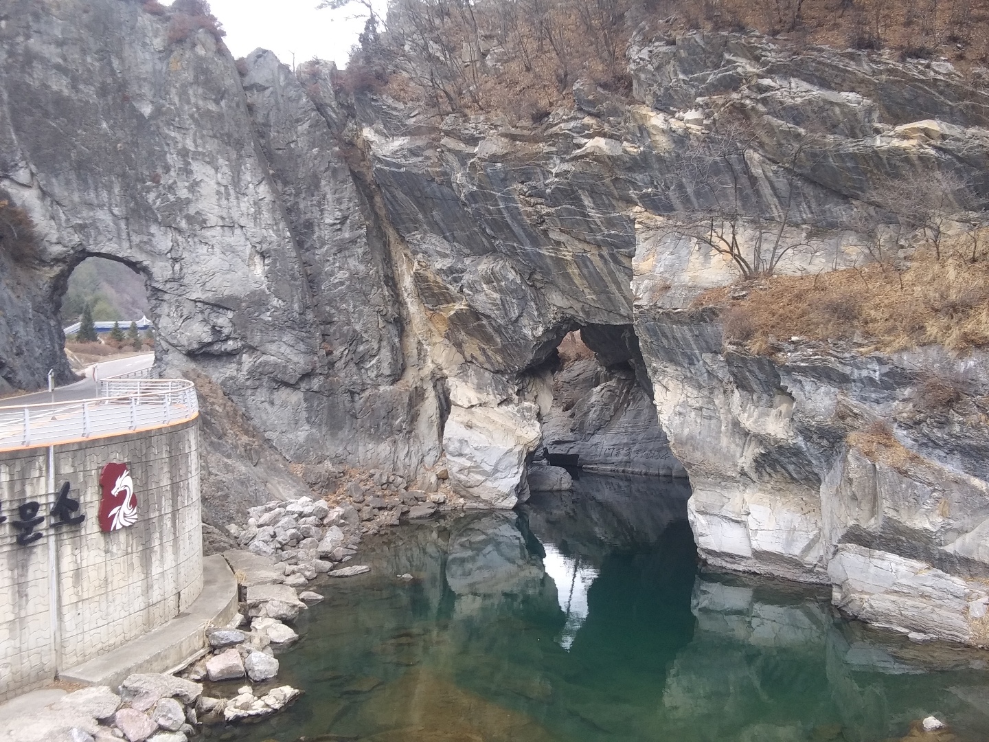
 Gumunso () is a swamp in Dongjeom-dong,

Video showcase
{{Coord, 37.0930, 129.0422, type:landmark_region:KR, display=title Swamps of Asia Natural Monuments of South Korea Taebaek Nakdong River
 Gumunso () is a swamp in Dongjeom-dong,
 Taebaek
Taebaek (; ) is a city in Gangwon Province, South Korea. Its name is shared with that of the Taebaek Mountains. Situated at an elevation of , Taebaek is the second highest city in South Korea, after Pyeongchang.
Etymology
Taebaek in is derived ...
, Gangwon Province, South Korea
Gangwon Province (), officially Gangwon State (), is a administrative divisions of South Korea, Special Self-Governing Province of South Korea. It is known as the largest and population density, least densely populated subdivision of South Korea. ...
which features a river that pierces through a mountain, the only one of its kind in Korea. It is also known for its geological value, as its stratigraphic
Stratigraphy is a branch of geology concerned with the study of rock layers (strata) and layering (stratification). It is primarily used in the study of sedimentary and layered volcanic rocks.
Stratigraphy has three related subfields: lithost ...
continuity is well-preserved. It names the surrounding village and neighborhood ( dong).
With an area of 685,109 m2, the "Ordovician Deposits and Topography of Stream Erosion of Gumunso" is a part of Gangwon Paleozoic National Geopark
A geopark is a protected area with internationally significant geology within which Sustainability, sustainable development is sought and which includes tourism, conservation, education and research concerning not just geology but other relevant s ...
and is the 417th Natural Monument of South Korea. In Gumunso, the Jigunsan and Makgol Formation (with the former unconformably overlying the latter) from the Lower Paleozoic
The Paleozoic ( , , ; or Palaeozoic) Era is the first of three Era (geology), geological eras of the Phanerozoic Eon. Beginning 538.8 million years ago (Ma), it succeeds the Neoproterozoic (the last era of the Proterozoic Eon) and ends 251.9 Ma a ...
Ordovician period (~440 to 500 million years ago) can be found. The two streams Cheoramcheon (철암천) and Hwangjicheon (황지천) meet in Gumunso, and could be considered the start of the Nakdong River
The Nakdong River or Nakdonggang (, ) is the longest river in South Korea, which passes through the major cities of Daegu and Busan. It takes its name from its role as the eastern border of the Gaya confederacy during Three Kingdoms of Korea, Kor ...
.


Name
The name Gumunso is aHanja
Hanja (; ), alternatively spelled Hancha, are Chinese characters used to write the Korean language. After characters were introduced to Korea to write Literary Chinese, they were adapted to write Korean as early as the Gojoseon period.
() ...
version of the name Gumuso (), where " 구무" is a Middle Korean term for "hole". A purely native-Korean name is Tturunae (, compare 뚫다). Historical documents such as the geological survey included in the ''Veritable Records of Sejong'' () and Daedongyeojido records the name as Cheoncheon (). The cave itself is called "자개문" (子開門).
Formation and history
Formation
During theOrdovician
The Ordovician ( ) is a geologic period and System (geology), system, the second of six periods of the Paleozoic Era (geology), Era, and the second of twelve periods of the Phanerozoic Eon (geology), Eon. The Ordovician spans 41.6 million years f ...
era, the Taebaek region was originally underseas, with organisms like coral depositing limestone that would form today's Gumunso. Some time after, the sea became isolated, and became extreme salty as it dried up. Because of this, rectangular imprints left by salt crystals are present on the rocks. Additionally, around Gumunso, sedimentary
Sedimentary rocks are types of rock formed by the cementation of sediments—i.e. particles made of minerals (geological detritus) or organic matter (biological detritus)—that have been accumulated or deposited at Earth's surface. Sedime ...
rocks can be found which were deposited during the Paleozoic Era
The Paleozoic ( , , ; or Palaeozoic) Era is the first of three geological eras of the Phanerozoic Eon. Beginning 538.8 million years ago (Ma), it succeeds the Neoproterozoic (the last era of the Proterozoic Eon) and ends 251.9 Ma at the start of ...
, approximately 520 to 460 million years ago. Geological structures like trilobite
Trilobites (; meaning "three-lobed entities") are extinction, extinct marine arthropods that form the class (biology), class Trilobita. One of the earliest groups of arthropods to appear in the fossil record, trilobites were among the most succ ...
fossils and stromatolites
Stromatolites ( ) or stromatoliths () are layered sedimentary formations ( microbialite) that are created mainly by photosynthetic microorganisms such as cyanobacteria, sulfate-reducing bacteria, and Pseudomonadota (formerly proteobacteria) ...
can be seen. Further upstream is the Jigunsan Formation, which contains abundant fossils. In 2000, calathid fossils was discovered in the Gumunso-adjacent Makgol Formation, the first to be found in the Korean peninsula.
From 30000 to 70000 years ago, Hwangjicheon used to have an extremely sharp rightward bend where today's Gumunso would be, eroding the limestone. The stream formed an Ω-shaped (or horseshoe-shaped) meander
A meander is one of a series of regular sinuous curves in the Channel (geography), channel of a river or other watercourse. It is produced as a watercourse erosion, erodes the sediments of an outer, concave bank (cut bank, cut bank or river cl ...
and deposited well-rounded gravel with interbedded sand. Dating shows that this sedimentary layer lasted for the aforementioned years. From 30000 to 10000 years ago, 40000 years of erosion has opened a small channel in through the limestone in Gumunso, reducing the flow to the meander. This was reflected by smaller pebbles being present in the deposits of that time. Around 30000 years ago, the hole was fully formed, and the weakened meander disappeared completely, becoming a swamp. Today, this abandoned channel consists of farmlands and is called 사군다리.
Modern
'' Sinjŭng Tongguk yŏji sŭngnam'', a 1530 geography book, notes: "The Hwangjicheon is located 110 '' ri'' west of Samcheok-bu. Its waters flow south for about 30 ''ri'', piercing through a small mountain and continuing southward—called Cheoncheon". During the Japanese colonial period, the Japanese dug a tunnel next to Gumunso in 1937, aiming to build a road to transport coal and workers. On 2000 April 28, the "Ordovician Deposits and Topography of Stream Erosion of Gumunso" was designated as the 417th Natural Monument of South Korea. In September 1998, the Taebaek city reduced the number of neighborhoods from 16 to 8, and merged Dongjeom-dong and a part of Jangseong-dong (장성동) together. The resulting dong was named Gumunso-dong.Folklore
There is a lot of folkloric myths surrounding Gumunso. One creation myth correctly identifies 사군다리 as an abandoned channel: the story involves a large tree that has been uprooted in a flood, explaining how it crashed into the mountain and created the tunnel. Another legend involves the legendary kingYu the Great
Yu the Great or Yu the Engineer was a legendary king in ancient China who was credited with "the first successful state efforts at flood control", his establishment of the Xia dynasty, which inaugurated Dynasties in Chinese history, dynastic ru ...
accidentally creating the tunnel with his sword while learning water control. One tells the story of the White Dragon blasting the tunnel while battling the Blue Dragon for the control over the Nakdong river. Historical prophetic work Jeonggamnok claims that going through the stone tunnel will during midnight will bring one to a paradise free from hunger.
The Dragon King
The Dragon King, also known as the Dragon God, is a Chinese water and weather god. He is regarded as the dispenser of rain, commanding over all bodies of water. He is the collective personification of the ancient concept of the '' lóng'' in ...
is also featured in a lot of folklore.
See also
*Meander cutoff
A meander cutoff is a natural form of a cutting or cut in a river occurs when a pronounced meander (hook) in a river is breached by a flow that connects the two closest parts of the hook to form a new channel, a full loop. The steeper drop in gra ...
* Geology of South Korea
Geology (). is a branch of natural science concerned with the Earth and other astronomical objects, the rocks of which they are composed, and the processes by which they change over time. Modern geology significantly overlaps all other Earth s ...
:* Geology of Taebaek
References
Journal citations
* *External links
Video showcase
{{Coord, 37.0930, 129.0422, type:landmark_region:KR, display=title Swamps of Asia Natural Monuments of South Korea Taebaek Nakdong River