|
Ghandruk
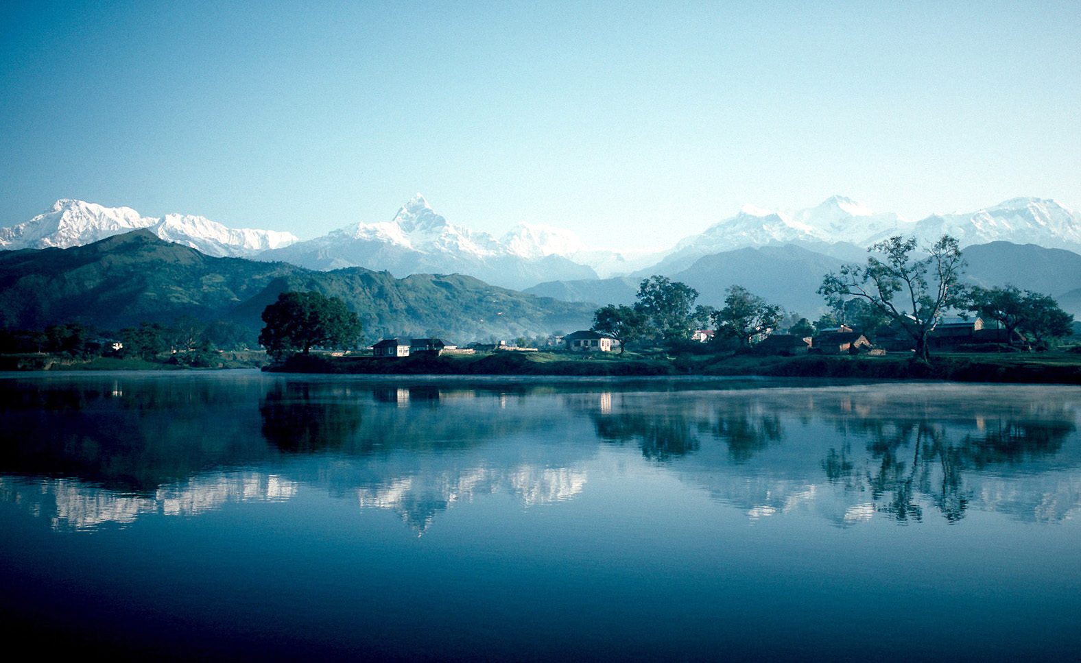
Ghandruk ( ne, घान्द्रुक ) is a Village Development Committee in the Kaski District of the Gandaki Province of Nepal. Situated at a distance of 32 km north-west to Pokhara, the village is readily accessible by public buses and private taxis from the provincial headquarter. At the time of the 1991 Nepal census, it had a population of 4,748 residing in 1,013 individual households. Ghandruk is a common place for treks in the Annapurna range of Nepal (Annapurna Base camp and Annapurna Circuit treks, in particular). The peaks of Mt Annapurna, Mt Machapuchare, Gangapurna and Mt Hiunchuli can be seen from the village, and it is also the gateway to the Poon hill. Gurung Gurung (exonym; ) or Tamu (endonym; Gurung: ) are an ethnic group indigenous to the hills and mountains of Gandaki Province of Nepal. Gurung people predominantly live around the Annapurna region in Manang, Mustang, Dolpo, Kaski, Lamjung, Gork ... communities comprise the major inhabitants of th ... [...More Info...] [...Related Items...] OR: [Wikipedia] [Google] [Baidu] |
Annapurna Circuit
The Annapurna Circuit is a trek within the mountain ranges of central Nepal. The total length of the route varies between 160–230 km (100-145 mi), depending on where motor transportation is used and where the trek is ended. This trek crosses two different river valleys and encircles the Annapurna Massif. The path reaches its highest point at Thorung La pass (5416m/17769 ft), reaching the edge of the Tibetan plateau. Most trekkers hike the route anticlockwise, as this way the daily altitude gain is slower, and crossing the high Thorong La pass is easier and safer. The mountain scenery, seen at close quarters includes the Annapurna Massif (Annapurna I-IV), Dhaulagiri, Machhapuchhre, Manaslu, Gangapurna, Tilicho Peak, Pisang Peak, and Paungda Danda. Numerous other peaks of 6000-8000m in elevation rise from the Annapurna range. The trek begins at Besisahar or Bhulbhule in the Marshyangdi river valley and concludes in the Kali Gandaki Gorge. Besisahar can be re ... [...More Info...] [...Related Items...] OR: [Wikipedia] [Google] [Baidu] |
Kaski District
Kaski District ( ne, कास्की जिल्ला, ), a part of Gandaki Province, is one of the seventy-seven districts of Nepal. The name is disambiguated from Kaskikot, the ancient Kaski Kingdom. The district, with Pokhara as its district headquarter, covers an area of 2,017 square km and had a total population of 492,098 according to 2011 Census. This district lies at the centroid point of the country. The altitude of Kaski district ranges from 450 meters the lowest land to 8091 meters the highest point in the Himalaya range. Kaski District politically has One Metropolitan City, 4 Gaupalika and 3 electoral sectors. The district covers parts of the Annapurna mountain range, and the picturesque scene of the mountains can be observed from most parts of the district. It is one of the best tourist destinations of Nepal. The district is full of rivers such as Seti Gandaki, Modi and Madi along with other rivulets. The district headquarters Pokhara lies about 750 m above the ... [...More Info...] [...Related Items...] OR: [Wikipedia] [Google] [Baidu] |
Gangapurna
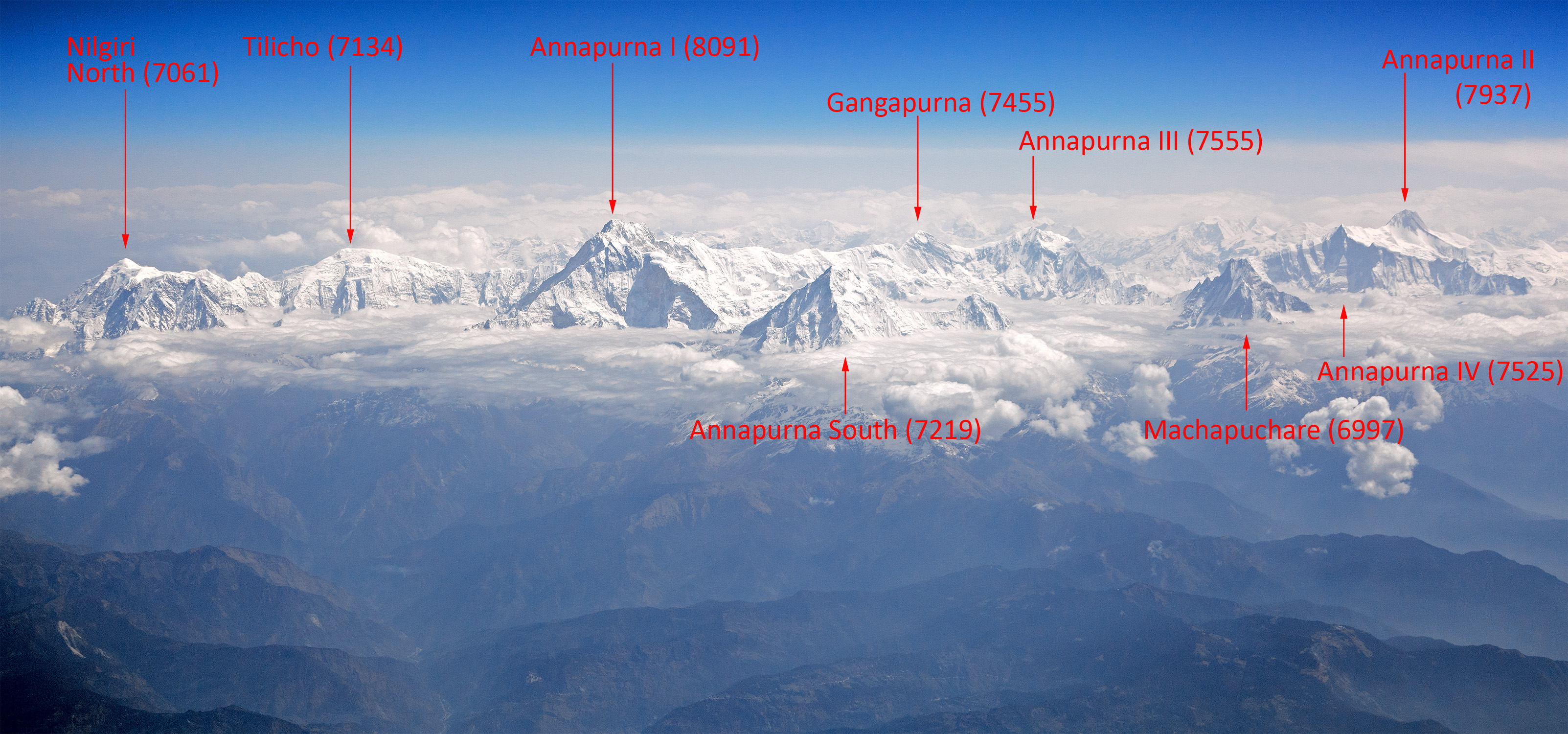
Gangapurna () is a mountain in Gandaki Province, Nepal. It is part of the Annapurna mountain range in north-central Nepal at an elevation of and with the prominence of . It was first ascended in 1965 by a German expedition via its south face and east ridge. Gangapurna is entirely located in the Annapurna Conservation Area. Geography Gangapurna is located at the border of Annapurna Rural Municipality, Kaski and Nesyang Rural Municipality, Manang in Gandaki Province at above sea level and its prominence is . It is part of the Annapurna mountain range in north-central Nepal, and Gangapurna is on the main ridge that connects Annapurna I to Gangapurna and Annapurna III. The main peak of the mountain range, Annapurna I Main, is the tenth highest mountain in the world at above sea level. The mountain is named after Ganga, the Hindu goddess who is a personification of the river Ganges. Gangapurna entirely lies in the Annapurna Conservation Area, Nepal's largest protec ... [...More Info...] [...Related Items...] OR: [Wikipedia] [Google] [Baidu] |
Pokhara
Pokhara ( ne, पोखरा, ) is a metropolitan city in Nepal, which serves as the capital of Gandaki Province. It is the second most populous city of Nepal after Kathmandu, with 518,452 inhabitants living in 101,669 households in 2021. It is the country's largest metropolitan city in terms of area. The city also serves as the headquarters of Kaski District. Pokhara is located west of the capital, Kathmandu. The city is on the shore of Phewa Lake, and sits at an elevation of approximately 822m. The Annapurna Range, with three out of the ten highest peaks in the world—Dhaulagiri, Annapurna I and Manaslu—is within of the valley. Pokhara is considered the tourism capital of Nepal, being a base for trekkers undertaking the Annapurna Circuit through the Annapurna Conservation Area region of the Annapurna ranges in the Himalayas. The city is also home to many of the elite Gurkha soldiers, soldiers native to South Asia of Nepalese nationality recruited for the Briti ... [...More Info...] [...Related Items...] OR: [Wikipedia] [Google] [Baidu] |
Annapurna Massif
Annapurna (; ne, अन्नपूर्ण) is a massif in the Himalayas in north-central Nepal that includes one peak over , thirteen peaks over , and sixteen more over . The massif is long, and is bounded by the Kali Gandaki Gorge on the west, the Marshyangdi River on the north and east, and by Pokhara Valley on the south. At the western end, the massif encloses a high basin called the Annapurna Sanctuary. The highest peak of the massif, Annapurna I Main, is the tenth highest mountain in the world at above sea level. Maurice Herzog led a French expedition to its summit through the north face in 1950, making it the first eight-thousand meter peak ever successfully climbed. The name for the range comes from the Hindu deity Annapurna meaning ''the giver of food and nourishment'' due to the evergreen flowing rivers originating from this mountain range which generates greenery and supports vegetation year round on the lower plains. She is also believed to be one of the daught ... [...More Info...] [...Related Items...] OR: [Wikipedia] [Google] [Baidu] |
Zones Of Nepal
Until the establishment of seven new provinces in 2015, Nepal was divided into 14 administrative zones (Nepali: अञ्चल; ''anchal'') and 77 districts (Nepali: जिल्ला; ''jillā''). The 14 administrative zones were grouped into five development regions (Nepali: विकास क्षेत्र; ''vikās kṣetra''). Each district was headed by a Chief District Officer (CDO), who was responsible for maintaining law and order and coordinating the work of field agencies of the various government ministries. From east to west: * Eastern Development Region: ** Mechi Zone, named after the Mechi River ** Kosi Zone, named after the Kosi River ** Sagarmatha Zone, named after Sagarmatha (Mount Everest) * Central Development Region: ** Janakpur Zone, named after its capital city ** Bagmati Zone, named after the Bagmati River ** Narayani Zone, named after the Narayani (lower Gandaki) River *Western Development Region: ** Gandaki Zone, named after the Gandaki Riv ... [...More Info...] [...Related Items...] OR: [Wikipedia] [Google] [Baidu] |
Annapurna
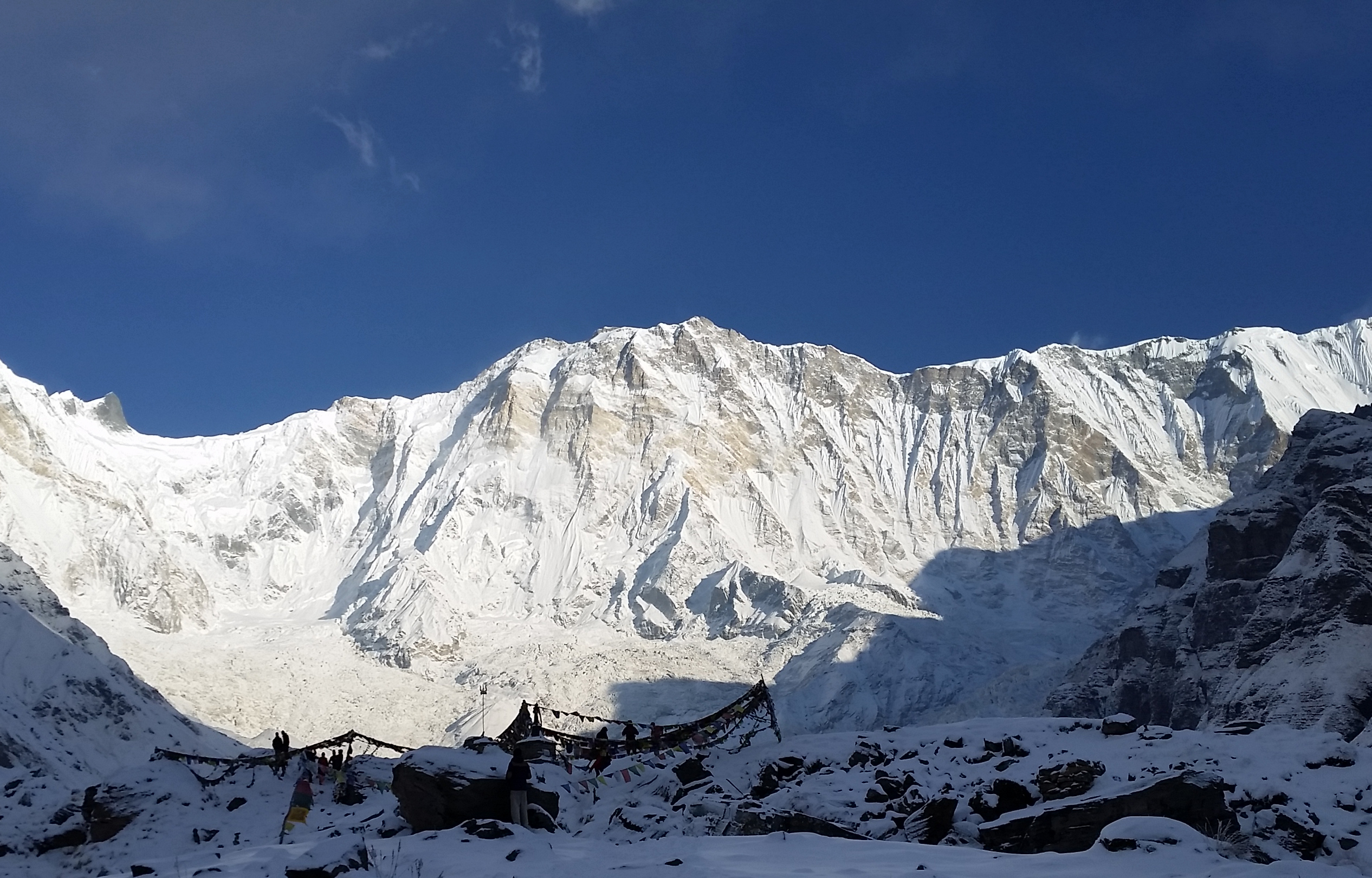
Annapurna (; ne, अन्नपूर्ण) is a mountain situated in the Annapurna mountain range of Gandaki Province, north-central Nepal. It is the tenth highest mountain in the world at above sea level and is well known for the difficulty and danger involved in its ascent. Maurice Herzog led a French expedition to its summit through the north face in 1950, making it the first eight-thousand meter peak ever successfully climbed. The entire massif and surrounding area are protected within the Annapurna Conservation Area, the first and largest conservation area in Nepal. The Annapurna Conservation Area is home to several world-class treks, including Annapurna Sanctuary and Annapurna Circuit. For decades, Annapurna I Main held the highest fatality-to-summit rate of all principal eight-thousander summits; it has, however, seen great climbing successes in recent years, with the fatality rate falling from 32% to just under 20% from 2012 to 2022. This figure places ... [...More Info...] [...Related Items...] OR: [Wikipedia] [Google] [Baidu] |
Poon Hill
Poon Hill (पून हिल) is a hill station overlooking the Annapurna Massif range and Dhaulagiri mountain range, located on border of Myagdi District and Kaski District in Gandaki Province of Nepal. This lookout is the key viewpoint in the Ghorepani Poon Hill trek. Mountains such as an Annapurna 8,091m, Dhaulagiri 8,127, Annapurna South 7,219 Meter, Machapuchare 6,993 Meter, Hinchuli, Annapurna III, Dhampus peak, Dhulagiri II, and many other tall peaks can be seen from here. Poon Hill is located 270 km west from Kathmandu (The capital of Nepal). The hike to Poon Hill from Pokhara takes 2–3 days. The Poon Hill viewpoint is on the way to Annapurna Sanctuary which lies in the centre of Annapurna Conservation Area Annapurna Conservation Area is Nepal's largest protected area covering in the Annapurna range of the Himalayas. It ranges in elevation from to the peak of Annapurna I at . The conservation area stretches across Manang, Mustang, Kaski, Myagdi, .... Trek ... [...More Info...] [...Related Items...] OR: [Wikipedia] [Google] [Baidu] |
Hiunchuli
Hiunchuli ( ne, हिउँचुली) is a peak situated in the Annapurna massif of the Gandaki Province in north-central Nepal. The mountain is an extension of the Annapurna South. Between this peak and the Machapuchare is a narrow section of the Modi Khola valley that constitutes the sole access to the Annapurna Sanctuary. Hiunchuli was first climbed in October 1971 by an expedition led by the U.S. Peace Corps volunteer Craig Anderson. The mountain is classified as a trekking peak The term "Trekking Peak" is a commonly misunderstood colloquial term which may refer to a variety of types of peaks in the Himalayan Region. The term is most often associated with Group "B" NMA Climbing Peaks classified by the Nepal Mountaineering ... by the Nepal Mountaineering Association (NMA), but it is considered one of the more difficult trekking peaks to climb due to route finding difficulties and dangers from rock fall and seracs. A climbing permit from the NMA costs US$350 for a team ... [...More Info...] [...Related Items...] OR: [Wikipedia] [Google] [Baidu] |
Machapuchare
Machapuchare, Machhapuchchhre or Machhapuchhre (, Tamu: कतासुँ क्लिको), is a mountain situated in the Annapurna massif of Gandaki Province, north-central Nepal. Its highest peak has never been officially climbed due to the impossibility of gaining a permit from the government of Nepal. Location Machapuchare is at the end of a long spur ridge, coming south out of the main backbone of the Annapurna massif, which forms the eastern boundary of the Annapurna Sanctuary. The peak is about north of the provincial headquarter of Pokhara. The sanctuary is a favorite trekking destination, and the site of the base camps for the South Face of Annapurna and for numerous smaller objectives. The Mardi Himal trek, for instance, climbs towards a minor peak. Notable features Due to its southern position in the range and the particularly low terrain that lies south of the Annapurna Himalayas, which contains three of the 10 highest peaks in the world, Machapuchare commands ... [...More Info...] [...Related Items...] OR: [Wikipedia] [Google] [Baidu] |
1991 Nepal Census
The 1991 Nepal census was a widespread national census conducted by the Nepal Central Bureau of Statistics. Working with Nepal's Village Development Committees at a district level, they recorded data from all the main towns and villages of each district of the country. The data included statistics on population size, households, sex and age distribution, place of birth, residence characteristics, literacy, marital status, religion, language spoken, caste/ethnic group, economically active population, education, number of children, employment status, and occupation. This census was followed by the 2001 Nepal census. References See also * List of village development committees of Nepal (Former) * 2001 Nepal census * 2011 Nepal census Nepal conducted a widespread national census in 2011 by the Nepal Central Bureau of Statistics. Working with the 58 municipalities and the 3915 Village Development Committees at a district level, they recorded data from all the municipalities ... [...More Info...] [...Related Items...] OR: [Wikipedia] [Google] [Baidu] |
Digital Himalaya
The Digital Himalaya project was established in December 2000 by Mark Turin, Alan Macfarlane, Sara Shneiderman, and Sarah Harrison. The project's principal goal is to collect and preserve historical multimedia materials relating to the Himalaya, such as photographs, recordings, and journals, and make those resources available over the internet and offline, on external storage media. The project team have digitized older ethnographic collections and data sets that were deteriorating in their analogue formats, so as to protect them from deterioration and make them available and accessible to originating communities in the Himalayan region and a global community of scholars. The project was founded at the Department of Anthropology of the University of Cambridge, moved to Cornell University in 2002 (when a collaboration with the University of Virginia was initiated), and then back to the University of Cambridge in 2005. From 2011 to 2014, the project was jointly hosted between the Uni ... [...More Info...] [...Related Items...] OR: [Wikipedia] [Google] [Baidu] |


