|
Duke Of York Islands
The Duke of York Islands (formerly ) are a group of islands located in East New Britain Province, Papua New Guinea. They are found in StGeorge's Channel between New Britain and New Ireland islands and form part of the Bismarck Archipelago. The Duke of York Islands were named in 1767 by Philip Carteret to honour Prince Edward, son of Frederick, Prince of Wales and younger brother of George III of the United Kingdom. History In the 1870s and 1880s German commercial firms began to site trading stations in New Guinea. Agents of J. C. Godeffroy & Sohn reached the Bismarck Archipelago from the Caroline Islands in 1872 and had established a trading post on the Islands from 1876. The wreck of HMAS ''AE1'', lost in 1914 possibly due to a diving accident, was located near these islands in December 2017 after 13 search missions. The submarine was found at a depth of and was seen to be well preserved and in one piece. The exact location of the wreck was not announced by the Australi ... [...More Info...] [...Related Items...] OR: [Wikipedia] [Google] [Baidu] |
Melanesia
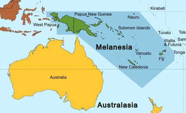
Melanesia (, ) is a subregion of Oceania in the southwestern Pacific Ocean. It extends from New Guinea in the west to the Fiji Islands in the east, and includes the Arafura Sea. The region includes the four independent countries of Fiji, Vanuatu, Solomon Islands, and Papua New Guinea. It also includes the West New Guinea, Indonesian part of New Guinea, the French overseas collectivity of New Caledonia, and the Torres Strait Islands. Almost all of the region is in the Southern Hemisphere; only a few small islands that are not politically considered part of Oceania—specifically the northwestern islands of Western New Guinea—lie in the Northern Hemisphere. The name ''Melanesia'' (in French, ''Mélanésie'') was first used in 1832 by French navigator Jules Dumont d'Urville: he coined the terms ''Melanesia'' and ''Micronesia'' to go alongside the pre-existing ''Polynesia'' to designate what he viewed as the three main Ethnicity, ethnic and geographical regions forming the Pacif ... [...More Info...] [...Related Items...] OR: [Wikipedia] [Google] [Baidu] |
Caroline Islands
The Caroline Islands (or the Carolines) are a widely scattered archipelago of tiny islands in the western Pacific Ocean, to the north of New Guinea. Politically, they are divided between the Federated States of Micronesia (FSM) in the central and eastern parts of the group, and Palau at the extreme western end. Historically, this area was also called ''Nuevas Filipinas'' or New Philippines, because they were part of the Spanish East Indies and were governed from Manila in the Philippines. The Carolines are scattered across a distance of approximately , from the westernmost island, Tobi (island), Tobi, in Palau, to the easternmost island, Kosrae, a Administrative divisions of the Federated States of Micronesia, state of the FSM. Description The group consists of about 500 small coral islands, east of the Philippines, in the Pacific Ocean. The distance from Yap (one of the larger Caroline islands) to Manila is . Most of the islands are made up of low, flat atoll, coral ato ... [...More Info...] [...Related Items...] OR: [Wikipedia] [Google] [Baidu] |
Sea Level Rise
The sea level has been rising from the end of the last ice age, which was around 20,000 years ago. Between 1901 and 2018, the average sea level rose by , with an increase of per year since the 1970s. This was faster than the sea level had ever risen over at least the past 3,000 years. The rate accelerated to /yr for the decade 2013–2022. Climate change due to human activities is the main cause. Between 1993 and 2018, melting ice sheets and glaciers accounted for 44% of sea level rise, with another 42% resulting from thermal expansion of water. Sea level rise lags behind changes in the Earth's temperature by decades, and sea level rise will therefore continue to accelerate between now and 2050 in response to warming that has already happened. What happens after that depends on future human greenhouse gas emissions. If there are very deep cuts in emissions, sea level rise would slow between 2050 and 2100. The reported factors of increase in flood hazard potential are often e ... [...More Info...] [...Related Items...] OR: [Wikipedia] [Google] [Baidu] |
Mualim Island
Mualim is an island in Duke of York Islands archipelago in Papua New Guinea. It is located in the east of the country, in the East New Britain Province, about to the east of the Port Moresby (; Tok Pisin: ''Pot Mosbi''), also referred to as Pom City or simply Moresby, is the capital and largest city of Papua New Guinea. It is one of the largest cities in the southwestern Pacific (along with Jayapura) outside of Australia and New .... Due to rising sea levels limiting land on the island, residents reportedly travel to other islands for food, firewood and water. References Islands of Papua New Guinea Islands Region (Papua New Guinea) {{PapuaNewGuinea-island-stub ... [...More Info...] [...Related Items...] OR: [Wikipedia] [Google] [Baidu] |
Mioko Island
Mioko is a populated island in the Duke of York Islands archipelago in Papua New Guinea. National Geospatial-Intelligence Agency, Bethesda, MD, USA Located in , in the east of the country, about north of Port Moresby
(; Tok Pisin: ''Pot Mosbi''), also referred to as Pom City or simply Moresby, is the capital and largest city of Papua New Guinea. It is one of the largest cities in the southwestern Pacific (along with Jayapura) outside of Austr ...
[...More Info...] [...Related Items...] OR: [Wikipedia] [Google] [Baidu] |
Ulu (island)
Ulu Island is the second largest island in the Duke of York island group. It is situated between Duke of York Island and Kabakon and Kerawara islands. The island is on Papua New Guinea Time (PGT). This works out as UTC/GMT +10:00 hours. They do not observe Daylight saving time. The word Ulu means breadfruit Breadfruit (''Artocarpus altilis'') is a species of flowering tree in the mulberry and jackfruit family ( Moraceae) believed to have been selectively bred in Polynesia from the breadnut ('' Artocarpus camansi''). Breadfruit was spread into .... Other names Ulu is also known as Mauke Island or Pig Island. References Islands of Papua New Guinea East New Britain Province {{EastNewBritainProvince-geo-stub ... [...More Info...] [...Related Items...] OR: [Wikipedia] [Google] [Baidu] |
Kerawara
Kerawara is an island in the Duke of York Islands archipelago in Papua New Guinea. National Geospatial-Intelligence Agency, Bethesda, MD, USA It is located in the east of the country, in the , about to the east of the Port Moresby
(; Tok Pisin: ''Pot Mosbi''), also referred to as Pom City or simply Moresby, is the capital and largest city of Papua New Guinea. It is one of the largest cities in the southwestern Pacific (along with J ...
[...More Info...] [...Related Items...] OR: [Wikipedia] [Google] [Baidu] |
Kabakon
Kabakon or Kaka Kon Island is a small island in group of Duke of York Islands in the Bismark Archipelago, Papua New Guinea. August Engelhardt chose Kabakon as the island to establish his Sun-worshipping sect, notable for only eating coconuts The coconut tree (''Cocos nucifera'') is a member of the palm tree family (biology), family (Arecaceae) and the only living species of the genus ''Cocos''. The term "coconut" (or the archaic "cocoanut") can refer to the whole coconut palm, ..., from 1902 until his death.Nina MartyriDeath By Coconut: A Story Of Food Obsession Gone Too FarDecember 3, 2015 References Islands of Papua New Guinea East New Britain Province {{EastNewBritainProvince-geo-stub ... [...More Info...] [...Related Items...] OR: [Wikipedia] [Google] [Baidu] |
Makada
Makada is an island in the Duke of York Islands archipelago in Papua New Guinea. National Geospatial-Intelligence Agency, Bethesda, MD, USA It is located in the east of the country, in the , about 800 km to the east of the Port Moresby
(; Tok Pisin: ''Pot Mosbi''), also referred to as Pom City or simply Moresby, is the capital and largest city of Papua New Guinea. It is one of the largest cities in the southwestern Pacific (along ...
[...More Info...] [...Related Items...] OR: [Wikipedia] [Google] [Baidu] |
Duke Of York Island, Papua New Guinea
Duke of York Island is the largest island of Duke of York Islands, Papua New Guinea, at . The island is named after Prince Frederick, the second son of King George III George III (George William Frederick; 4 June 173829 January 1820) was King of Great Britain and King of Ireland, Ireland from 25 October 1760 until his death in 1820. The Acts of Union 1800 unified Kingdom of Great Britain, Great Britain and ... of Great Britain. Shared name There is also a Duke of York Island (Antarctica), Duke of York Island at in North Victoria Land in East-Antarctica, at the southern end of Robertson Bay, not far from Cape Adare. References [...More Info...] [...Related Items...] OR: [Wikipedia] [Google] [Baidu] |
Duke Of York Islands
The Duke of York Islands (formerly ) are a group of islands located in East New Britain Province, Papua New Guinea. They are found in StGeorge's Channel between New Britain and New Ireland islands and form part of the Bismarck Archipelago. The Duke of York Islands were named in 1767 by Philip Carteret to honour Prince Edward, son of Frederick, Prince of Wales and younger brother of George III of the United Kingdom. History In the 1870s and 1880s German commercial firms began to site trading stations in New Guinea. Agents of J. C. Godeffroy & Sohn reached the Bismarck Archipelago from the Caroline Islands in 1872 and had established a trading post on the Islands from 1876. The wreck of HMAS ''AE1'', lost in 1914 possibly due to a diving accident, was located near these islands in December 2017 after 13 search missions. The submarine was found at a depth of and was seen to be well preserved and in one piece. The exact location of the wreck was not announced by the Australi ... [...More Info...] [...Related Items...] OR: [Wikipedia] [Google] [Baidu] |
Navy News
''Navy News'' is the official newspaper of the British Royal Navy The Royal Navy (RN) is the naval warfare force of the United Kingdom. It is a component of His Majesty's Naval Service, and its officers hold their commissions from the King of the United Kingdom, King. Although warships were used by Kingdom ..., produced by a small team of editorial and support staff and published by the Ministry of Defence on a monthly basis. The content of the newspaper is varied, ranging from information for all serving personnel of whatever rank or specialisation to Sea Cadets and former shipmates. Members of the public with an interest in the Royal Navy, Royal Marines and the Fleet Air Arm also have access to the newspaper. The newspaper is distributed free to serving personnel (ratio 1:5), and is available to members of the public through subscription or through a newsagent. Up to 35,000 copies are printed each month. ''Navy News'' includes sections on news; special features; sport; ... [...More Info...] [...Related Items...] OR: [Wikipedia] [Google] [Baidu] |


