|
Downtown Riyadh
Downtown Riyadh () is a term used for a group of 20 neighborhoods in Riyadh, Saudi Arabia. Covering an area of more than 3700 acres, it hosts some of the city's most important cultural and commercial districts, such as the King Abdulaziz Historical Center, the Al Batʼha (Riyadh), al-Batʼha commercial area and the Qasr Al Hukm District, Qasr al-Hukm District, while simultaneously overlapping with many of the Old Riyadh, old city areas of the capital metropolis, including the erstwhile walled town of Riyadh, walled town. The first downtown development plan was introduced in 2013 by the Royal Commission for Riyadh City. The downtown is bounded by Al-Washm Street and Omar bin Al-Khattab Street in the north, Al-Kharj Road in the east, Ammar bin Yasir Street and Al-A’sha Street in the south, and Imam Abdulaziz bin Muhammad Street in the west. Districts Qasr al-Hukm District Qasr al-Hukm District is a term used to define the perimeters of the erstwhile walled town of Riyadh in ... [...More Info...] [...Related Items...] OR: [Wikipedia] [Google] [Baidu] |
Neighborhood
A neighbourhood (Commonwealth English) or neighborhood (American English) is a geographically localized community within a larger town, city, suburb or rural area, sometimes consisting of a single street and the buildings lining it. Neighbourhoods are often social communities with considerable face-to-face interaction among members. Researchers have not agreed on an exact definition, but the following may serve as a starting point: "Neighbourhood is generally defined spatially as a specific geographic area and functionally as a set of social networks. Neighbourhoods, then, are the spatial units in which face-to-face social interactions occur—the personal settings and situations where residents seek to realise common values, socialise youth, and maintain effective social control." Preindustrial cities In the words of the urban scholar Lewis Mumford, "Neighborhoods, in some annoying, inchoate fashion exist wherever human beings congregate, in permanent family dwellings; ... [...More Info...] [...Related Items...] OR: [Wikipedia] [Google] [Baidu] |
Al Fouta
Al-Fouta (), alternatively transliterated as al-Futa, is a neighborhood in central Riyadh, Saudi Arabia, located south of al-Murabba and north of al-Dirah in the sub-municipality of al-Malaz. It emerged in the 1940s following the construction of the Red Palace for then Saudi crown prince Saud bin Abdulaziz and al-Futa Palaces. It popularly hosts the Riyadh Water Tower, one of the notable landmarks in the city as well as the rest of the southern portion of the King Abdulaziz Historical Center King Abdulaziz Historical Center (KAHC) () is a cross-district heritage complex in Riyadh, Saudi Arabia, covering south of Al Murabba, al-Murabba and north of Al Fouta, al-Futah. Inaugurated in 1999, it includes several historic buildings and ope ..., including the eponymous al-Fouta Park. As the neighborhood is bounded by al-Batʼha Street to the east, its eastern strip partially forms part of the al-Batʼha commercial area. The neighborhood is unofficially divided into two sections, ... [...More Info...] [...Related Items...] OR: [Wikipedia] [Google] [Baidu] |
Old Riyadh
Old Riyadh () is an umbrella term used for a loosely defined region that primarily lies in the southern portion of modern-day Riyadh, Saudi Arabia, encompassing neighborhoods and settlements that emerged from the ruins of Hajr al-Yamamah in late 16th century or existed during pre-Islamic era, the erstwhile walled town (today Qasr Al Hukm District) enclosed within the defensive fortifications and its immediate vicinity prior to its demolition in the 1950s, villages and not former towns located along the outskirts of Riyadh (such as Irqah and Manfuhah) that got incorporated into the metropolis following multiple phases of expansion and modernization between the 1950s and 1970s. To some extent, neighborhoods excluded during Riyadh's rapid urbanization during the same period are also categorized as part of old districts, with most of them situated in the modern downtown. History Early origins in pre-Islamic Arabia Before the advent of Islam in the 7th century, the settlement u ... [...More Info...] [...Related Items...] OR: [Wikipedia] [Google] [Baidu] |
Qasr Al Hukm District
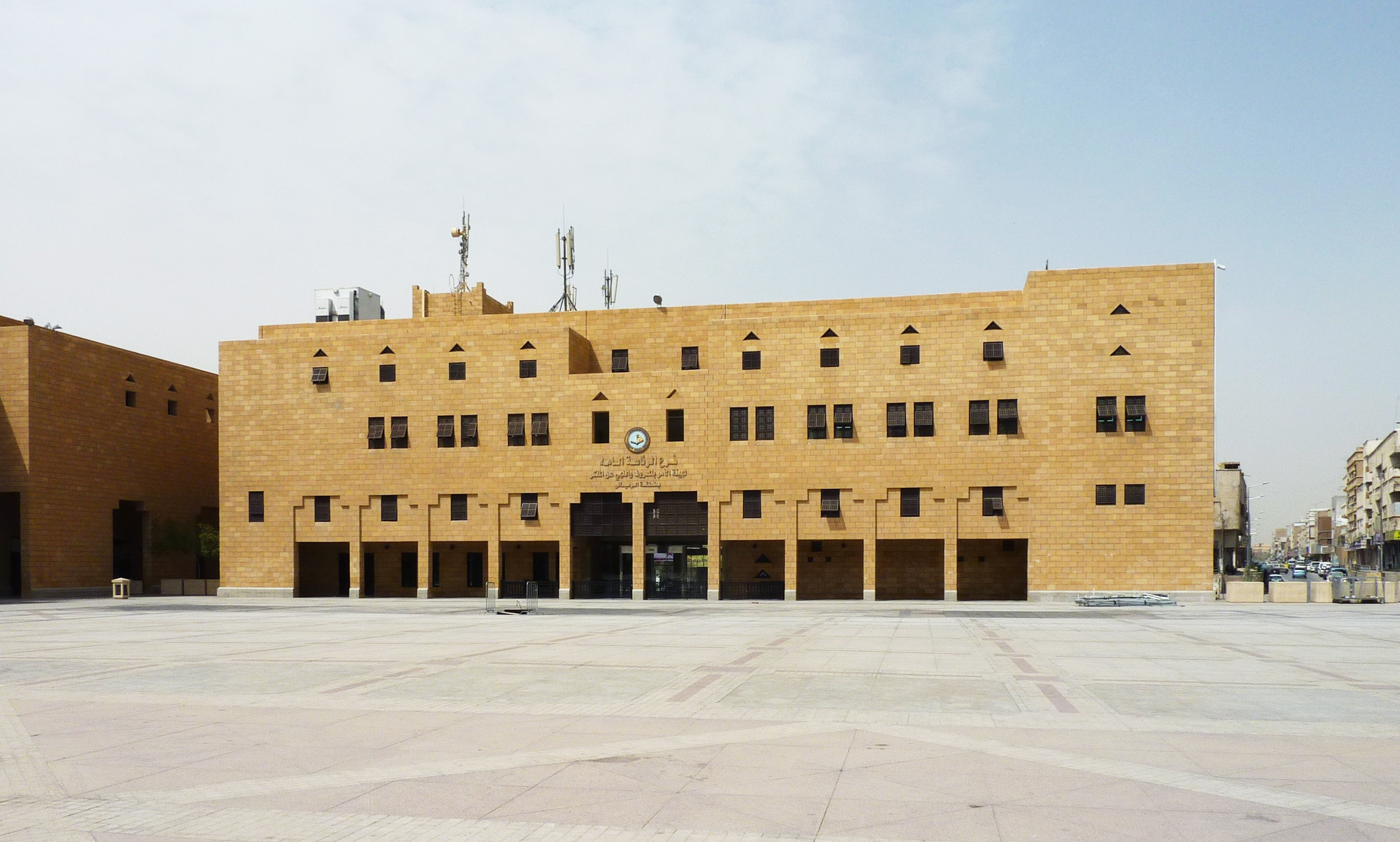
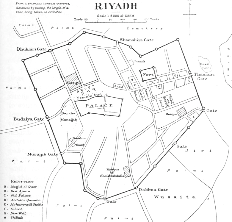
Qasr al-Hukm District () or the Justice Palace District (), is a term used to define the area within the perimeters of the erstwhile walled town of Riyadh in Riyadh, Saudi Arabia, encompassing present-day districts of ad-Dirah and ad-Doho, that lie on several extinct douars () that once fell within the enclosure of the gates of old city walls prior to its demolition in the 1950s. Named after the eponymous al-Hukm Palace, it is widely considered to be the antecedent to modern Riyadh since the metropolis outgrew as an offshoot of the walled town in the 1950s. Owing to its historical and architectural significance, it was rebuilt by the Saudi government from 1973 to 1992 and is situated southwest of al-Batʼha commercial area. It hosts some of the most important cultural heritage landmarks in the city, such as Masmak Fortress, Imam Turki bin Abdullah Grand Mosque, Deera Square and the eponymous al-Hukm Palace besides several traditional marketplaces. History and background ... [...More Info...] [...Related Items...] OR: [Wikipedia] [Google] [Baidu] |
Al Batʼha (Riyadh)
Al-Batʼha (), also simply romanized as Batha, is a colloquial umbrella term used for the partial agglomeration of six neighborhoods in downtown Riyadh, Saudi Arabia, that are primarily situated along the al-Batʼha Street on the either edge of the now-dried up stream of Wadi al-Batʼha, located between al-Murabba and the Qasr al-Hukm District. It is one of the oldest commercial districts in Riyadh and the financial nerve center of the city's downtown area, covering east of al-Futah and al-Dirah whereas west of al-Amal, Margab, Thulaim and to some extent, al-Oud. It emerged in the 1940s as Hillat al-Kuwaitiyyah () during World War II when a number of Kuwaiti merchants and traders chose to set up an auction market just outside the northeastern fringes of the erstwhile walled town. Besides being a open-air marketplace that hosts a number of large and medium-scale trading centers, the surrounding locality has been the heart of the city's Bangladeshi community since the ... [...More Info...] [...Related Items...] OR: [Wikipedia] [Google] [Baidu] |
Saudi Arabia
Saudi Arabia, officially the Kingdom of Saudi Arabia (KSA), is a country in West Asia. Located in the centre of the Middle East, it covers the bulk of the Arabian Peninsula and has a land area of about , making it the List of Asian countries by area, fifth-largest country in Asia, the largest in the Middle East, and the List of countries and dependencies by area, 12th-largest in the world. It is bordered by the Red Sea to the west; Jordan, Iraq, and Kuwait to the north; the Persian Gulf, Bahrain, Qatar and the United Arab Emirates to the east; Oman to the southeast; and Yemen to Saudi Arabia–Yemen border, the south. The Gulf of Aqaba in the northwest separates Saudi Arabia from Egypt and Israel. Saudi Arabia is the only country with a coastline along both the Red Sea and the Persian Gulf, and most of Geography of Saudi Arabia, its terrain consists of Arabian Desert, arid desert, lowland, steppe, and List of mountains in Saudi Arabia, mountains. The capital and List of cities ... [...More Info...] [...Related Items...] OR: [Wikipedia] [Google] [Baidu] |
Salam Park
Salam Park () is a 61-acre historic urban park in Riyadh, Saudi Arabia, located southwest of Qasr al-Hukm District. Opened in 2004, it was built on the site of an eponymous date palm orchard that belonged to Prince Abdullah bin Abdul Rahman. The park is popular for its 3.3 hectares large artificial lake and 1-kilometer long pedestrian track. It was jointly designed by Omrania and Associates and Aukett Fitzroy Robinson. The Salam Mosque, one of the oldest and earliest reinforced concrete mosques of Riyadh, is situated at the center of the park. Overview In the 1990s, the Royal Commission for Riyadh City acquired the date palm orchard, known as Salam, that belonged to Prince Abdullah bin Abdul Rahman. The park was inaugurated in 2004 by Prince Salman bin Abdulaziz Salman bin Abdulaziz Al Saud (; born 31 December 1935) has been King of Saudi Arabia since 2015, and was Prime Minister of Saudi Arabia from 2015 to 2022. He is the 25th son of King Abdulaziz, the founder of S ... [...More Info...] [...Related Items...] OR: [Wikipedia] [Google] [Baidu] |
Al Dubiyah (Riyadh)
Al-Dubiyah (), pronounced as ad-Dubiyah, is a subject of Baladiyah al-Batha and one of the oldest neighborhoods of Riyadh, Saudi Arabia, located between Mikal and as-Salam. The area is known for its traditional mud-brick houses and derelict earth structure An earth structure is a building or other structure made largely from soil. Since soil is a widely available material, it has been used in construction since prehistory. It may be combined with other materials, compressed and/or baked to add ...d buildings. References Neighbourhoods in Riyadh {{Riyadh-geo-stub ... [...More Info...] [...Related Items...] OR: [Wikipedia] [Google] [Baidu] |
Miʼkal (Riyadh)
Miʼkal or Maʼkal () is an ancient village and a historic neighborhood in southern Riyadh, Saudi Arabia, located that is a subject of Baladiyah al-Batha in southern Riyadh, Saudi Arabia, located between ad-Dubiyah and al-Wusaita. The town came into existence when Hajr al-Yamamah disintegrated up into several settlements and estates in the 16th century (10 AH), the most notable of them being Migrin (or Muqrin) and Ma'kal. Its name reportedly comes from two pre-Islamic Arabian deities, Kāl and Maʿkāl () that were worshipped in Najd. History The town came into existence when Hajr al-Yamamah disintegrated up into several settlements and estates in the 16th century (10th century AH), the most notable of them being Migrin (or Muqrin) and Ma'kal. It was reportedly named after two pre-Islamic Arabian deities, Kāl and Maʿkāl () that were worshipped in Najd. According to historian Abd al-Malik ibn Husayn al-Isami al-Makki, Maʼkal was also the site of a military conflict wh ... [...More Info...] [...Related Items...] OR: [Wikipedia] [Google] [Baidu] |
Al Wusaita (Riyadh)
Al-Wusaita () is a subject of Baladiyah al-Batha and one of the oldest neighborhoods of the city in southern Riyadh, Saudi Arabia Riyadh is the capital and largest city of Saudi Arabia. It is also the capital of the Riyadh Province and the centre of the Riyadh Governorate. Located on the eastern bank of Wadi Hanifa, the current form of the metropolis largely emerged in th ..., inhabited mostly by overseas Asians. It shares proximity with Jabrah and Al Dirah neighborhoods. References Neighbourhoods in Riyadh {{Riyadh-geo-stub ... [...More Info...] [...Related Items...] OR: [Wikipedia] [Google] [Baidu] |
Al Bateha (Riyadh)
Al-Bateha () is a subject of Baladiyah al-Batha and one of the oldest neighborhoods in southern Riyadh, Saudi Arabia Riyadh is the capital and largest city of Saudi Arabia. It is also the capital of the Riyadh Province and the centre of the Riyadh Governorate. Located on the eastern bank of Wadi Hanifa, the current form of the metropolis largely emerged in th ..., located between Jabrah and Manfuhah al-Jadidah. References Neighbourhoods in Riyadh Economy of Riyadh Shopping districts and streets {{Riyadh-geo-stub ... [...More Info...] [...Related Items...] OR: [Wikipedia] [Google] [Baidu] |
Gabrah (Riyadh)
Jabrah () or Gabrah, is a subject of Baladiyah al-Batha and one of the oldest neighborhoods that came into being after the disintegration of Hajr al-Yamamah in southern Riyadh, Saudi Arabia Riyadh is the capital and largest city of Saudi Arabia. It is also the capital of the Riyadh Province and the centre of the Riyadh Governorate. Located on the eastern bank of Wadi Hanifa, the current form of the metropolis largely emerged in th .... The area also gets synonymous with al-Batha or ad-Dirah because of its close proximity with them. References Neighbourhoods in Riyadh {{Riyadh-geo-stub ... [...More Info...] [...Related Items...] OR: [Wikipedia] [Google] [Baidu] |


