|
Conejohela Valley
The Conejohela Flats are a group of islands in the flooded Conejohela Valley, a large floodplain along the southernmost 30 miles (50 km) of the Susquehanna River in Pennsylvania and Maryland in the United States. The valley was flooded primarily during the early 1900s by the construction of the Holtwood, Conowingo, and Safe Harbor dams from 1910 to 1931. Geography and history Before the twentieth century, the Conejohela Valley was a marshy floodplain, with extensive wetlands. The Susquehanna River flooded annually in the spring, and there were more damaging floods approximately once per decade. Thick forests surrounded a mixture of small waterfalls, rapids, and marshes. A wide, flat valley formed; the frequently wide river was a substantial barrier to crossing, both for Native Americans and for colonists. The varied terrain created many nurturing biological habitats, but human passage across the valley and river was extremely difficult. The Susquehanna is very wide in this a ... [...More Info...] [...Related Items...] OR: [Wikipedia] [Google] [Baidu] |
Susquehanna River
The Susquehanna River ( ; Unami language, Lenape: ) is a major river located in the Mid-Atlantic (United States), Mid-Atlantic region of the United States, crossing three lower Northeastern United States, Northeast states (New York, Pennsylvania and Maryland). At long, it is the longest river on the East Coast of the United States. By Drainage basin, watershed area, it is the 16th-largest river in the United States,Susquehanna River Trail Pennsylvania Fish and Boat Commission, accessed March 25, 2010.Susquehanna River , Green Works Radio, accessed March 25, 2010. and also the longest river in the early 21st-century continental United State ... [...More Info...] [...Related Items...] OR: [Wikipedia] [Google] [Baidu] |
Lake Clarke
Lake Clarke in Pennsylvania is a man-made lake along the Susquehanna River formed by the Safe Harbor Dam, a public works project of the 1930s Great Depression and one of the electrification projects of the New Deal. It is approximately long centered within the Conejohela Valley approximately downstream of historic Wright's Ferry (1630−1901). Safe Harbor Water Power Corporation provides picnic areas, boat ramps, playgrounds and other public recreation facilities at several locations on both sides of the lake. Lake Clarke is home to Long Level Marina, Safe Harbor's boat-access areas, Susquehanna Yacht Club, Lake Clarke Rescue Inc., and two private marinas that are located on the York County side of the lake. The United States Coast Guard Auxiliary Flotilla 19-5 (Division 19 (5th District Northern Region (NR)) patrols the area of Lake Clarke and is based out of Auxiliary Station Long Level, 1960 Long Level Road, Wrightsville, on the York County side of the lake. See also * ... [...More Info...] [...Related Items...] OR: [Wikipedia] [Google] [Baidu] |
Landforms Of Lancaster County, Pennsylvania
A landform is a land feature on the solid surface of the Earth or other planetary body. They may be natural or may be anthropogenic (caused or influenced by human activity). Landforms together make up a given terrain, and their arrangement in the landscape is known as topography. Landforms include hills, mountains, canyons, and valleys, as well as shoreline features such as bays, peninsulas, and seas, including submerged features such as mid-ocean ridges, volcanoes, and the great oceanic basins. Physical characteristics Landforms are categorized by characteristic physical attributes such as elevation, slope, orientation, structure stratification, rock exposure, and soil type. Gross physical features or landforms include intuitive elements such as berms, cliffs, hills, mounds, peninsulas, ridges, rivers, valleys, volcanoes, and numerous other structural and size-scaled (e.g. ponds vs. lakes, hills vs. mountains) elements including various kinds of inland and oceanic waterbodi ... [...More Info...] [...Related Items...] OR: [Wikipedia] [Google] [Baidu] |
Crossings Of The Susquehanna River
Crossings may refer to: * ''Crossings'' (Buffy novel), a 2002 original novel based on the U.S. television series ''Buffy the Vampire Slayer'' * Crossings (game), a two-player abstract strategy board game invented by Robert Abbott * ''Crossings'' (Herbie Hancock album), 1972 * ''Crossings'' (journal), an academic journal on art * ''Crossings'' (Red Garland album), 1978 * ''Crossings'' (Steel novel), a 1982 novel by Danielle Steel * ''Crossings'' (Tony Rice album), 1994 * ''Crossings'' (TV miniseries), a 1986 miniseries directed by Karen Arthur, starring Cheryl Ladd and Lee Horsley and * ''Crossings'' (TV series), a Malaysian dark comedy drama series * Pedestrian crossing, a designated point on a road at which some means are employed to assist pedestrians wishing to cross * Zebra crossing, also known as a crosswalk See also * Crossing (other) * The Crossing (other) The Crossing may refer to: Books * The Crossing (play), ''The Crossing'' (play), a 2006 p ... [...More Info...] [...Related Items...] OR: [Wikipedia] [Google] [Baidu] |
Thomas Cresap
Colonel Thomas Cresap (1702 1790) was an English-born settler and trader in the states of Maryland and Pennsylvania. Cresap served Lord Baltimore as an agent in the Maryland–Pennsylvania boundary dispute that became known as Cresap's War. Later, together with the Native American chief Nemacolin, Cresap improved a Native American path to the Ohio Valley, and ultimately settled and became a large landowner near Cumberland, Maryland, where he was involved in further disputes near Brownsville, Pennsylvania, including in the French and Indian War and Lord Dunmore's War. Early life Cresap was born in Skipton, Yorkshire, England, and emigrated across the Atlantic Ocean to the Maryland colony when he was 15 years old. In 1723, he gave his occupation as that of a carpenter. He initially settled at the mouth of the Susquehanna River on the Chesapeake, on the lower end of a floodplain called the Conejohela Valley, and built boats. In 1725, Cresap married Hannah Johnson, whose fath ... [...More Info...] [...Related Items...] OR: [Wikipedia] [Google] [Baidu] |
Susquehanna River Dams
The Susquehanna River, in the Mid-Atlantic States of the United States, has a collection of dams. These dams are used for power generation, flood control, navigation and recreation. The first dams at Sunbury, Pennsylvania were to support year round ferry crossings. The dams slow water, trapping silt and pollutants. Conowingo Dam is credited with preventing much of the silt from Pennsylvania from reaching the Chesapeake Bay. The dam spillways can add oxygen to the water. The down stream side of dams is favored by aquatic birds, possibly because the fish that pass through the dam are a bit stunned. Hydroelectric power is an environmentally friendly method of power generation. The dams also raise the water level, altering the riparian environment. The upstream pools can become environmentally unsound below the surface, especially during summer. They block migratory fish, such as the American shad. The dams from York Haven down to the Chesapeake all have fish ladders or lif ... [...More Info...] [...Related Items...] OR: [Wikipedia] [Google] [Baidu] |
Cresap's War
Cresap's War (also known as the Conojocular War, from the Conejohela Valley where it was mainly located along the south bank) was a border conflict between Pennsylvania and Maryland fought in the 1730s. Hostilities erupted in 1730 with a series of violent incidents prompted by disputes over property rights and law enforcement. The conflict escalated through the first half of the decade, culminating in the deployment of military forces by Maryland in 1736 and by Pennsylvania in 1737. The armed phase of the conflict ended in May 1738 with the intervention of King George II, who compelled the negotiation of a ceasefire. A final settlement was not achieved until 1767 when the Mason–Dixon line was recognized as the permanent boundary between the two colonies. Background Pennsylvania's Charter (1681) specified that the colony was bounded "on the South by a Circle drawne at twelve miles 9 kmdistance from New Castle Northward and Westward unto the beginning of the fortieth degre ... [...More Info...] [...Related Items...] OR: [Wikipedia] [Google] [Baidu] |
Riparian
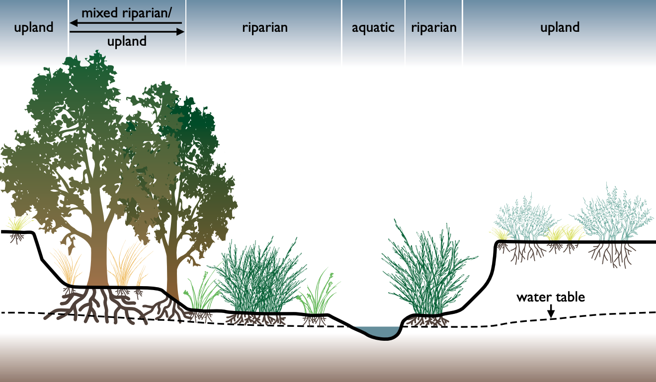
A riparian zone or riparian area is the interface between land and a river or stream. In some regions, the terms riparian woodland, riparian forest, riparian buffer zone, riparian corridor, and riparian strip are used to characterize a riparian zone. The word ''riparian'' is derived from Latin '' ripa'', meaning " river bank". Riparian is also the proper nomenclature for one of the terrestrial biomes of the Earth. Plant habitats and communities along the river margins and banks are called riparian vegetation, characterized by hydrophilic plants. Riparian zones are important in ecology, environmental resource management, and civil engineering because of their role in soil conservation, their habitat biodiversity, and the influence they have on terrestrial and semiaquatic fauna as well as aquatic ecosystems, including grasslands, woodlands, wetlands, and even non-vegetative areas. Riparian zones may be natural or engineered for soil stabilization or restoration. These zon ... [...More Info...] [...Related Items...] OR: [Wikipedia] [Google] [Baidu] |
Game Fish
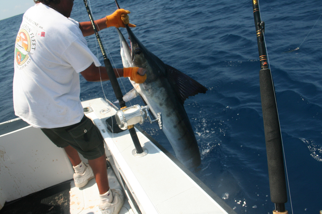
Game fish, sport fish or quarry refer to popular fish species pursued by recreational fishing, recreational fishers (typically angling, anglers), and can be freshwater fish, freshwater or saltwater fish. Game fish can be fish as food, eaten after being caught, preserved as taxidermy (though rare), or catch and release, released after capture. Some game fish are also targeted commercial fishing, commercially, particularly less bony species such as salmon and tuna. Specimens of game fish whose fish measurement, measurements (body length and standard weight in fish, weight) significantly exceed the species' average are sometimes known as trophy fish, as such captures are often presented as bragging rights among fishers. Examples The species of fish prized by anglers varies with geography and tradition. Some fish are sought for their value as seafood, food, while others are pursued for their fighting abilities, or for the difficulty of successfully enticing the fish to bite th ... [...More Info...] [...Related Items...] OR: [Wikipedia] [Google] [Baidu] |
Amtrak's 25 Hz Traction Power System
The traction power network of Amtrak uses 25 Hz for the southern portion of the Northeast Corridor (NEC), the Keystone Corridor, and several branch lines between New York City and Washington D.C. The system was constructed by the Pennsylvania Railroad between 1915 and 1938 before the North American power transmission grid was fully established. This is the reason the system uses 25 Hz, as opposed to 60 Hz, which became the standard frequency for power transmission in North America. The system is also known as the Southend Electrification, in contrast to Amtrak's 60 Hz traction power system that runs between Boston and New Haven, which is known as the Northend Electrification system. In 1976, Amtrak inherited the system from Penn Central Transportation Company, Penn Central, the successor to the Pennsylvania Railroad, along with the rest of the NEC infrastructure. Only about half of the system's electrical capacity is used by Amtrak; the remainder is sold to the reg ... [...More Info...] [...Related Items...] OR: [Wikipedia] [Google] [Baidu] |
Pennsylvania
Pennsylvania, officially the Commonwealth of Pennsylvania, is a U.S. state, state spanning the Mid-Atlantic (United States), Mid-Atlantic, Northeastern United States, Northeastern, Appalachian, and Great Lakes region, Great Lakes regions of the United States. It borders Delaware to its southeast, Maryland to its south, West Virginia to its southwest, Ohio and the Ohio River to its west, Lake Erie and New York (state), New York to its north, the Delaware River and New Jersey to its east, and the Provinces and territories of Canada, Canadian province of Ontario to its northwest via Lake Erie. Pennsylvania's most populous city is Philadelphia. Pennsylvania was founded in 1681 through a royal land grant to William Penn, the son of William Penn (Royal Navy officer), the state's namesake. Before that, between 1638 and 1655, a southeast portion of the state was part of New Sweden, a Swedish Empire, Swedish colony. Established as a haven for religious and political tolerance, the B ... [...More Info...] [...Related Items...] OR: [Wikipedia] [Google] [Baidu] |


