|
Colliford
Colliford Lake is a reservoir on Bodmin Moor, Cornwall, England, United Kingdom. Covering more than , it is the largest lake in Cornwall. It is situated south of the A30 trunk road near the village of Bolventor, the approximate centre of the lake being at . Dozmary Pool outfalls into the lake and the lake's own outfall forms one of the tributaries of the River Fowey. The northernmost point of the lake is approximately three-quarters of a mile (1 km) south of Bolventor at and the headbank at the southernmost point is approximately three miles (5 km) south of Bolventor at . Leisure facilities on the site include angling and a adventure and nature park, Colliford Lake Park, which features trails and footpaths, play areas, wetlands, picnic areas and a cafe. Colliford Lake is managed by the South West Lakes Trust, an environmental and recreational charity which manages fifty inland water sites in Cornwall, Devon, and Somerset. See also * List of reservoirs and dams i ... [...More Info...] [...Related Items...] OR: [Wikipedia] [Google] [Baidu] |
Dozmary Pool
Dozmary Pool is a small lake, in the civil parish of Altarnun on Bodmin Moor, Cornwall, UK. It is situated from the sea and lies about north-east of Bodmin and south of Bolventor. It originated in the post-glacial period. The outflow from the pool is into Colliford Lake and is therefore one of the sources of the River Fowey. In the past the name has been spelt as Dozmaré and as Dosmery Pool. The pool and surrounding area was designated a Site of Special Scientific Interest in 1951 for its biological interest and is within the Cornwall Area of Outstanding Natural Beauty (originally the Bodmin Moor AONB). Wildlife and ecology The oligotrophic pool is important for its palynological record (or history) of the vegetation since the last ice-age. It is also part of a network of sites in south-west England for the reconstruction of vegetation history. In the fine granitic gravel on the bottom of the pool grows spring quillwort ('' Isoetes echinospora''). At the time of des ... [...More Info...] [...Related Items...] OR: [Wikipedia] [Google] [Baidu] |
River Fowey
The River Fowey ( ; ) is a river in Cornwall, England, United Kingdom. Its source (river), source is at Fowey Well (originally , meaning ''spring of the river Fowey'') about north-west of Brown Willy on Bodmin Moor, not far from one of its tributaries rising at Dozmary Pool and Colliford Lake, passes Lanhydrock House, Restormel Castle and Lostwithiel, then broadens below Milltown, Lanlivery, Milltown before joining the English Channel at Fowey. The estuary is called Uzell (, meaning ''howling place''). It is only navigable by larger craft for the last . From Fowey, there is a passenger ferry to Polruan and a car ferry to Bodinnick. The first road crossing going upstream is in Lostwithiel. The river has seven tributaries, the largest being the Lerryn, River Lerryn. The section of the Fowey Valley between Doublebois and Bodmin Parkway railway station is known as the Glynn Valley (, meaning ''deep wooded valley''). The valley is the route of both the A38 trunk road and the railway l ... [...More Info...] [...Related Items...] OR: [Wikipedia] [Google] [Baidu] |
Bodmin Moor
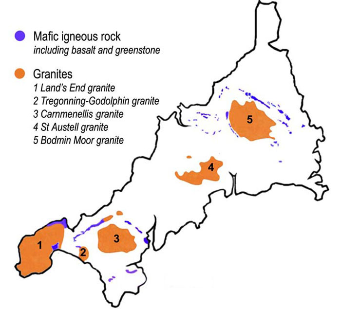
Bodmin Moor () is a granite moorland in north-eastern Cornwall, England, United Kingdom. It is in size, and dates from the Carboniferous period of geology, geological history. It includes Brown Willy, the highest point in Cornwall, and Rough Tor, a slightly lower peak. Many of Cornwall's rivers have their sources here. It has been inhabited since at least the Neolithic era, when early farmers started clearing trees and farming the land. They left their megalithic monuments, hut circles and cairns, and the Bronze Age culture that followed left further cairns, and more stone circles and stone rows. By medieval and modern times, nearly all the forest was gone and livestock rearing predominated. The name Bodmin Moor is relatively recent. An early mention is in the ''Royal Cornwall Gazette'' of 28 November 1812. The upland area was formerly known as Fowey Moor after the River Fowey, which rises within it. Geology Bodmin Moor is one of five granite plutons in Cornwall that make up pa ... [...More Info...] [...Related Items...] OR: [Wikipedia] [Google] [Baidu] |
List Of Reservoirs And Dams In The United Kingdom
This is a list of dams and reservoirs in the United Kingdom. England Buckinghamshire *Foxcote Reservoir and Wood, Foxcote Reservoir, north of Buckingham *Weston Turville Reservoir, between Weston Turville and Wendover Cambridgeshire *Grafham Water Cheshire *Bollinhurst Reservoir *Bosley Reservoir, Bosley *Horse Coppice Reservoir *Lamaload Reservoir, east of Macclesfield * Lymm Dam, Lymm. *Ridgegate Reservoir and Trentabank Reservoir, south-east of Macclesfield *Sutton Reservoir, south of Macclesfield Cornwall * Argal and College Reservoirs, Falmouth, Cornwall, Falmouth * Boscathnoe Reservoir, Penzance * Bussow Reservoir, St Ives, Cornwall, St Ives * Cargenwen Reservoir * Colliford Lake, Bodmin Moor * Crowdy Reservoir, Bodmin Moor * Drift Reservoir, Penzance * Porth Reservoir, Newquay * Siblyback Lake, Bodmin Moor * Stithians Reservoir * Upper Tamar Lake (Devon and Cornwall) County Durham *Balderhead Reservoir *Blackton Reservoir *Burnhope Reservoir *Derwent Reservoir (Nort ... [...More Info...] [...Related Items...] OR: [Wikipedia] [Google] [Baidu] |
Cornwall
Cornwall (; or ) is a Ceremonial counties of England, ceremonial county in South West England. It is also one of the Celtic nations and the homeland of the Cornish people. The county is bordered by the Atlantic Ocean to the north and west, Devon to the east, and the English Channel to the south. The largest urban area is the Redruth and Camborne conurbation. The county is predominantly rural, with an area of and population of 568,210. After the Redruth-Camborne conurbation, the largest settlements are Falmouth, Cornwall, Falmouth, Penzance, Newquay, St Austell, and Truro. For Local government in England, local government purposes most of Cornwall is a Unitary authorities of England, unitary authority area, with the Isles of Scilly governed by a Council of the Isles of Scilly, unique local authority. The Cornish nationalism, Cornish nationalist movement disputes the constitutional status of Cornwall and seeks greater autonomy within the United Kingdom. Cornwall is the weste ... [...More Info...] [...Related Items...] OR: [Wikipedia] [Google] [Baidu] |
England
England is a Countries of the United Kingdom, country that is part of the United Kingdom. It is located on the island of Great Britain, of which it covers about 62%, and List of islands of England, more than 100 smaller adjacent islands. It shares Anglo-Scottish border, a land border with Scotland to the north and England–Wales border, another land border with Wales to the west, and is otherwise surrounded by the North Sea to the east, the English Channel to the south, the Celtic Sea to the south-west, and the Irish Sea to the west. Continental Europe lies to the south-east, and Ireland to the west. At the 2021 United Kingdom census, 2021 census, the population was 56,490,048. London is both List of urban areas in the United Kingdom, the largest city and the Capital city, capital. The area now called England was first inhabited by modern humans during the Upper Paleolithic. It takes its name from the Angles (tribe), Angles, a Germanic peoples, Germanic tribe who settled du ... [...More Info...] [...Related Items...] OR: [Wikipedia] [Google] [Baidu] |
United Kingdom
The United Kingdom of Great Britain and Northern Ireland, commonly known as the United Kingdom (UK) or Britain, is a country in Northwestern Europe, off the coast of European mainland, the continental mainland. It comprises England, Scotland, Wales and Northern Ireland. The UK includes the island of Great Britain, the north-eastern part of the island of Ireland, and most of List of islands of the United Kingdom, the smaller islands within the British Isles, covering . Northern Ireland shares Republic of Ireland–United Kingdom border, a land border with the Republic of Ireland; otherwise, the UK is surrounded by the Atlantic Ocean, the North Sea, the English Channel, the Celtic Sea and the Irish Sea. It maintains sovereignty over the British Overseas Territories, which are located across various oceans and seas globally. The UK had an estimated population of over 68.2 million people in 2023. The capital and largest city of both England and the UK is London. The cities o ... [...More Info...] [...Related Items...] OR: [Wikipedia] [Google] [Baidu] |
Reservoir
A reservoir (; ) is an enlarged lake behind a dam, usually built to water storage, store fresh water, often doubling for hydroelectric power generation. Reservoirs are created by controlling a watercourse that drains an existing body of water, interrupting a watercourse to form an Bay, embayment within it, excavating, or building any number of retaining walls or levees to enclose any area to store water. Types Dammed valleys Dammed reservoirs are artificial lakes created and controlled by a dam constructed across a valley and rely on the natural topography to provide most of the basin of the reservoir. These reservoirs can either be ''on-stream reservoirs'', which are located on the original streambed of the downstream river and are filled by stream, creeks, rivers or rainwater that surface runoff, runs off the surrounding forested catchments, or ''off-stream reservoirs'', which receive water diversion, diverted water from a nearby stream or aqueduct (water supply), aq ... [...More Info...] [...Related Items...] OR: [Wikipedia] [Google] [Baidu] |
A30 Road
The A30 is a major road in England, running WSW from London to Land's End. The road has been a principal axis in Britain from the 17th century to early 19th century, as a major coaching route and post road. It used to provide the fastest route from London to the South West by land until a century before roads were numbered; nowadays much of this function is performed by the M3 (including A316) and A303 roads. The road has kept its principal status in the west from Honiton, Devon to Land's End where it is mainly dual carriageway and retains trunk road status. Route London to Honiton The A30 begins at Henlys Roundabout, where the route stems from the A4 near Hounslow. It crosses the A312 before running south of the Southern Perimeter Road, Heathrow Airport and north of Ashford and Staines-upon-Thames, before reaching the M25 motorway orbital motorway. This first section is entirely dual carriageway. Taken with the A4, its natural continuation which nearby becomes non ... [...More Info...] [...Related Items...] OR: [Wikipedia] [Google] [Baidu] |
Bolventor
Bolventor () is a hamlet on Bodmin Moor in Cornwall, England, United Kingdom. It is situated in Altarnun civil parish between Launceston and Bodmin. Toponymy The hamlet has been said to take its name from the "Bold Venture" that it must have appeared to build a farm in this moorland, but this is probably folk etymology, as "Bol-" is a common prefix in Cornish placenames. It is much more likely that the name derives from the 'Bold Adventure' tin-working area which was in operation near Jamaica Inn during the 1840s-1850s Jamaica Inn Bolventor is the location of the famous Jamaica Inn coaching inn. It is bypassed by a dual carriageway section of the A30 trunk road; before the bypass was built the hamlet straddled the A30 road. Daphne du Maurier, a former resident, chose Bolventor as the setting for her novel about Cornish smugglers titled '' Jamaica Inn''. The inn that inspired the novel, Jamaica Inn, has stood beside the main road through the village since 1547. It is now a ... [...More Info...] [...Related Items...] OR: [Wikipedia] [Google] [Baidu] |
Angling
Angling (from Old English ''angol'', meaning "hook") is a fishing technique that uses a fish hook attached to a fishing line to tether individual fish in the mouth. The fishing line is usually manipulated with a fishing rod, although rodless techniques such as handlining also exist. Modern angling rods are usually fitted with a fishing reel that functions as a crank (mechanism), cranking device for storing, retrieving and releasing out the line, although Tenkara fishing and traditional cane pole fishing are two rod-angling methods that do not use any reel. The fish hook itself can be additionally weighted with a denser fishing tackle, tackle called a sinker (fishing), sinker, and is typically dressed with an appetizing bait (luring substance), bait (i.e. hookbait) to attract and entice the fish into swallowing the hook, but sometimes an inedible fake/imitation bait with multiple attached hooks (known as a fishing lure, lure) is used instead of a single hook with edible bait. Som ... [...More Info...] [...Related Items...] OR: [Wikipedia] [Google] [Baidu] |


