|
Cirrocumulus
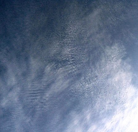
Cirrocumulus is one of the three main genus types of high-altitude tropospheric clouds, the other two being cirrus and cirrostratus. They usually occur at an altitude of , however they can occur as low as in the arctic and weather reporting standards such as the Canadian MANOBS suggests heights of in summer and in winter. Like lower-altitude cumuliform and stratocumuliform clouds, cirrocumulus signifies convection. Unlike other high-altitude tropospheric clouds like cirrus and cirrostratus, cirrocumulus includes a small amount of liquid water droplets, although these are in a supercooled Supercooling, also known as undercooling, is the process of lowering the temperature of a liquid below its freezing point without it becoming a solid. Per the established international definition, supercooling means ''‘cooling a substance be ... state. Ice crystals are the predominant component, and typically, the ice crystals cause the supercooled water drops in the cloud to rapidly ... [...More Info...] [...Related Items...] OR: [Wikipedia] [Google] [Baidu] |
Cirrocumulus Clouds July 2010
Cirrocumulus is one of the three main genus types of high-altitude tropospheric clouds, the other two being cirrus and cirrostratus. They usually occur at an altitude of , however they can occur as low as in the arctic and weather reporting standards such as the Canadian MANOBS suggests heights of in summer and in winter. Like lower-altitude cumuliform and stratocumuliform clouds, cirrocumulus signifies convection. Unlike other high-altitude tropospheric clouds like cirrus and cirrostratus, cirrocumulus includes a small amount of liquid water droplets, although these are in a supercooled state. Ice crystals are the predominant component, and typically, the ice crystals cause the supercooled water drops in the cloud to rapidly freeze, transforming the cirrocumulus into cirrostratus. This process can also produce precipitation in the form of a virga consisting of ice or snow. Thus, cirrocumulus clouds are usually short-lived., p.21 They usually only form as part of a short-lived ... [...More Info...] [...Related Items...] OR: [Wikipedia] [Google] [Baidu] |
Cirrocumulus Castellanus
Cirrocumulus castellanus or Cirrocumulus castellatus is a type of cirrocumulus cloud. '' Castellanus'' is from the Latin meaning "of a castle". These clouds appear as round turrets that are rising from either a lowered line or sheet of clouds. Cirrocumulus castellanus is an indicator of atmospheric instability at the level of the cloud. The clouds form when condensation occurs in the base cloud, causing latent heating to occur. This causes air to rise from the base cloud, and if the air ascends into conditionally unstable air, cirrocumulus castellanus will form. See also *List of cloud types The list of cloud types groups all genera as ''high'' (cirro-, cirrus), ''middle'' (alto-), ''multi-level'' (nimbo-, cumulo-, cumulus), and ''low'' (strato-, stratus). These groupings are determined by the altitude level or levels in the troposphe ... References External linksInternational Cloud Atlas – Cirrocumulus castellanus Cirrus Cumulus {{Cloud-stub ... [...More Info...] [...Related Items...] OR: [Wikipedia] [Google] [Baidu] |
Cirrocumulus Stratiformis
Cirrocumulus stratiformis is a type of cirrocumulus cloud. The name ''cirrocumulus stratiformis'' is derived from Latin, meaning "stretched out". Cirrocumulus stratiformis occurs as very small cirrocumulus clouds that cover a large part of the sky. This type of cloud always occurs in thin layers. There can be spaces or rifts between the individual cloudlets in the layer. See also *List of cloud types References External linksInternational Cloud Atlas – Cirrocumulus stratiformis Cirrus Cumulus {{Cloud-stub ... [...More Info...] [...Related Items...] OR: [Wikipedia] [Google] [Baidu] |
Cirrocumulus Lenticularis
Cirrocumulus lenticularis is a type of cirrocumulus cloud. The name ''cirrocumulus lenticularis'' is derived from Latin, meaning "like a lentil". Cirrocumulus lenticularis are smooth clouds that have the appearance of a lens or an almond. They usually form at the crests of atmospheric waves, which would otherwise be invisible. This species of cirrocumulus can often be quite elongated and normally has very distinguished boundaries. Cirrocumulus lenticularis forms when stable air is forced upward; this is usually due to orographic features, but can occur away from mountains as well. Irisation can occasionally occur with these clouds. See also * Altocumulus lenticularis * Stratocumulus lenticularis *List of cloud types The list of cloud types groups all genera as ''high'' (cirro-, cirrus), ''middle'' (alto-), ''multi-level'' (nimbo-, cumulo-, cumulus), and ''low'' (strato-, stratus). These groupings are determined by the altitude level or levels in the troposphe ... References E ... [...More Info...] [...Related Items...] OR: [Wikipedia] [Google] [Baidu] |
Cirrus Cloud
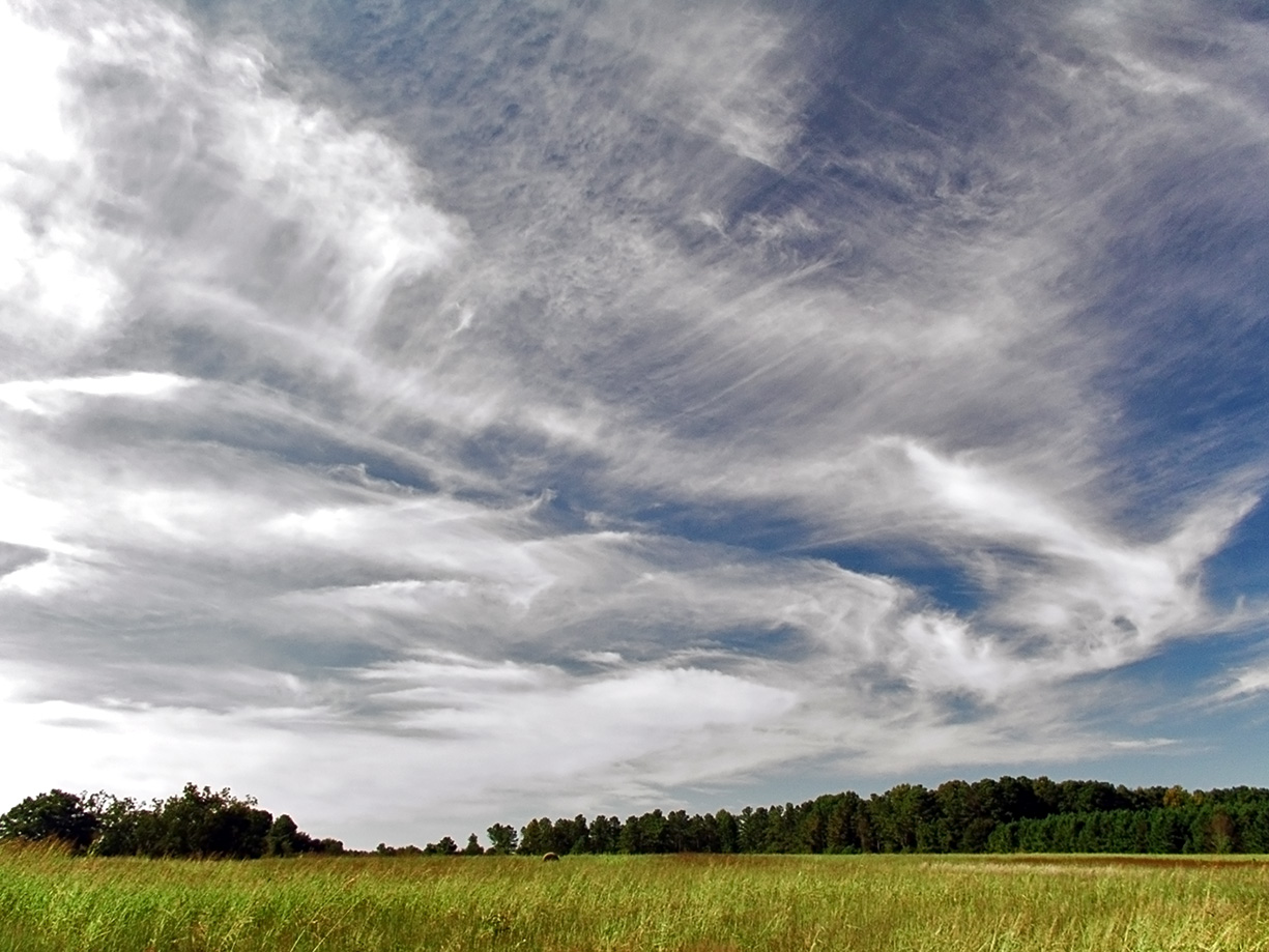
Cirrus ( cloud classification symbol: Ci) is a genus of high cloud made of ice crystals. Cirrus clouds typically appear delicate and wispy with white strands. In the Earth's atmosphere, cirrus are usually formed when warm, dry air rises, causing water vapor deposition onto mineral dust and metallic particles at high altitudes. Globally, they form anywhere between above sea level, with the higher elevations usually in the tropics and the lower elevations in more polar regions. Cirrus clouds can form from the tops of thunderstorms and tropical cyclones and sometimes predict the arrival of rain or storms. Although they are a sign that rain and maybe storms are on the way, cirrus themselves drop no more than falling streaks of ice crystals. These crystals dissipate, melt, and evaporate as they fall through warmer and drier air and never reach ground. The word ''cirrus'' comes from the Latin prefix ''cirro-'', meaning "tendril" or "curl". Cirrus clouds warm the earth, potentially c ... [...More Info...] [...Related Items...] OR: [Wikipedia] [Google] [Baidu] |
Cirrocumulus Floccus
Cirrocumulus floccus is a type of cirrocumulus cloud. The name ''cirrocumulus floccus'' is derived from Latin, meaning "a lock of wool". Cirrocumulus floccus appears as small tufts of cloud with rounded heads, but ragged bottoms. The cloud can produce virga, precipitation that evaporates before reaching the ground. Like cirrocumulus castellanus, cirrocumulus floccus is an indicator of atmospheric instability at the level of the cloud. In fact, cirrocumulus floccus can form from cirrocumulus castellanus, being the evolutionary state after the base of the original cloud has dissipated. See also *List of cloud types The list of cloud types groups all genera as ''high'' (cirro-, cirrus), ''middle'' (alto-), ''multi-level'' (nimbo-, cumulo-, cumulus), and ''low'' (strato-, stratus). These groupings are determined by the altitude level or levels in the troposphe ... References External linksInternational Cloud Atlas – Cirrocumulus floccus {{Cloud types Cirrus Cumulus ... [...More Info...] [...Related Items...] OR: [Wikipedia] [Google] [Baidu] |
Cirrocumulus Undulatus
Cirrocumulus undulatus is a variety of cirrocumulus cloud. The name ''cirrocumulus undulatus'' is derived from Latin, meaning "diversified as with waves". They have a rippled appearance due to wind shear and usually cover only a small portion of the sky. They appear in bands as small patches or layers. Occasionally, they comprise two or more wave forms superposed upon one another. The individual cloudlets can either be circular or elongated in the direction of the rows. See also *List of cloud types The list of cloud types groups all genera as ''high'' (cirro-, cirrus), ''middle'' (alto-), ''multi-level'' (nimbo-, cumulo-, cumulus), and ''low'' (strato-, stratus). These groupings are determined by the altitude level or levels in the troposphe ... References External linksInternational Cloud Atlas – Cirrocumulus undulatus Cirrus Cumulus {{Cloud-stub ... [...More Info...] [...Related Items...] OR: [Wikipedia] [Google] [Baidu] |
Cloud
In meteorology, a cloud is an aerosol consisting of a visible mass of miniature liquid droplets, frozen crystals, or other particles, suspended in the atmosphere of a planetary body or similar space. Water or various other chemicals may compose the droplets and crystals. On Earth, clouds are formed as a result of saturation of the air when it is cooled to its dew point, or when it gains sufficient moisture (usually in the form of water vapor) from an adjacent source to raise the dew point to the ambient temperature. Clouds are seen in the Earth's homosphere, which includes the troposphere, stratosphere, and mesosphere. Nephology is the science of clouds, which is undertaken in the cloud physics branch of meteorology. The World Meteorological Organization uses two methods of naming clouds in their respective layers of the homosphere, Latin and common name. Genus types in the troposphere, the atmospheric layer closest to Earth's surface, have Latin names because of th ... [...More Info...] [...Related Items...] OR: [Wikipedia] [Google] [Baidu] |
Mackerel Sky
A mackerel sky is a term for clouds made up of rows of cirrocumulus or altocumulus clouds displaying an undulating, rippling pattern similar in appearance to fish scales; this is caused by high altitude atmospheric waves. Cirrocumulus appears almost exclusively with cirrus some way ahead of a warm front and is a reliable forecaster that the weather is about to change. When these high clouds progressively invade the sky and the barometric pressure begins to fall, precipitation associated with the disturbance is likely about 6 to 12 hours away. A thickening and lowering of cirrocumulus into middle-étage altostratus or altocumulus is a good sign that the warm front or low front has moved closer and it may start raining within less than six hours. The old rhymes "Mackerel sky, not twenty-four hours dry" and " Mares' tails and mackerel scales make lofty ships to carry low sails" both refer to this long-recognized phenomenon. Other phrases in weather lore take mackerel skies as a ... [...More Info...] [...Related Items...] OR: [Wikipedia] [Google] [Baidu] |
Virga
A virga, also called a dry storm, is an observable streak or shaft of precipitation that evaporates or sublimates before reaching the ground. A shaft of precipitation that does not evaporate before reaching the ground is known in meteorology as a precipitation shaft. At high altitudes, precipitation falls mainly as ice crystals before melting and finally evaporating. That is often due to compressional heating, because air pressure increases closer to the ground. Virga is very common in deserts and temperate climates. In North America, it is commonly seen in the Western United States and the Canadian Prairies. It is also very common in the Middle East, Australia, and North Africa. Virgae can cause varying weather effects because as rain is changed from liquid to vapor form it removes significant amounts of heat from the air due to water's high heat of vaporization. Precipitation falling into these cooling downdrafts may eventually reach the ground. In some instances ... [...More Info...] [...Related Items...] OR: [Wikipedia] [Google] [Baidu] |
Cirrostratus Cloud
Cirrostratus () is a high-altitude, very thin, and generally uniform stratiform genus-type of cloud. It is composed of ice crystals, which are particles of frozen water. Cirrostratus is difficult to see and can produce halos. These optical effects are caused when the cloud takes the form of thin cirrostratus nebulosus. The cloud has a fibrous texture with no halos if it is thicker cirrostratus fibratus. On the approach of a frontal system, the cirrostratus often begins as nebulous and turns to fibratus. If the cirrostratus begins as fragmented of clouds in the sky it often means the front is weak. Cirrostratus usually lies above . Its presence indicates a large amount of moisture in the upper troposphere. Clouds resembling cirrostratus occasionally form in the lower stratosphere over the polar regions of Earth. Polar stratospheric clouds can take on this appearance when composed of tiny supercooled droplets of water or nitric acid. Cirrostratus clouds sometimes sig ... [...More Info...] [...Related Items...] OR: [Wikipedia] [Google] [Baidu] |
Atmospheric Convection
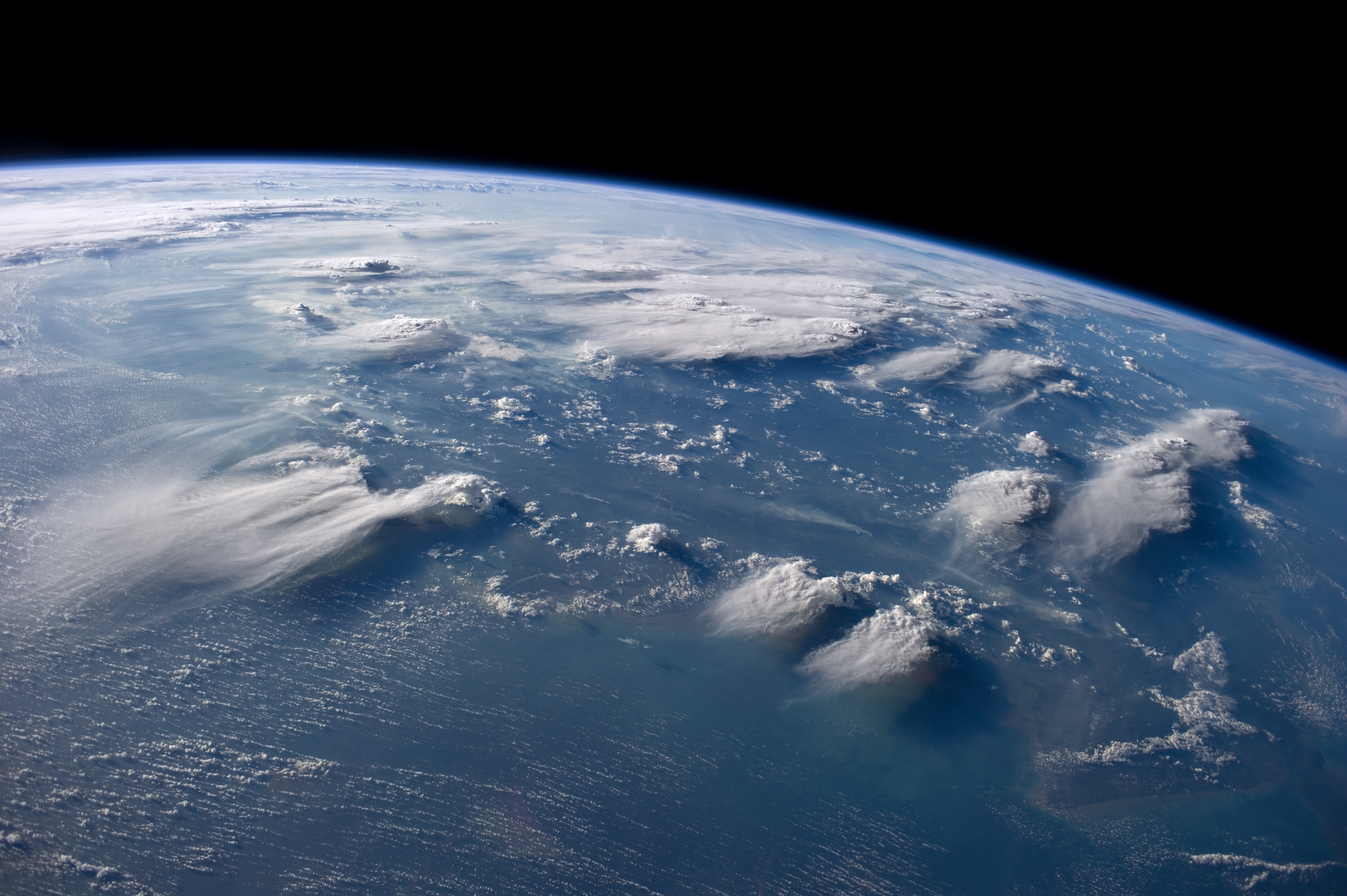
Atmospheric convection is the vertical transport of heat and moisture in the atmosphere. It occurs when warmer, less dense air rises, while cooler, denser air sinks. This process is driven by parcel-environment instability, meaning that a "parcel" of air is warmer and less dense than the surrounding environment at the same altitude. This difference in temperature and density (and sometimes humidity) causes the parcel to rise, a process known as buoyancy. This rising air, along with the compensating sinking air, leads to mixing, which in turn expands the height of the planetary boundary layer (PBL), the lowest part of the atmosphere directly influenced by the Earth's surface. This expansion contributes to increased winds, cumulus cloud development, and decreased surface dew points (the temperature below which condensation occurs). Convection plays a crucial role in weather patterns, influencing cloud formation, wind, and the development of thunderstorms, which can be associa ... [...More Info...] [...Related Items...] OR: [Wikipedia] [Google] [Baidu] |


