|
Virga
A virga, also called a dry storm, is an observable streak or shaft of precipitation that evaporates or sublimates before reaching the ground. A shaft of precipitation that does not evaporate before reaching the ground is known in meteorology as a precipitation shaft. At high altitudes, precipitation falls mainly as ice crystals before melting and finally evaporating. That is often due to compressional heating, because air pressure increases closer to the ground. Virga is very common in deserts and temperate climates. In North America, it is commonly seen in the Western United States and the Canadian Prairies. It is also very common in the Middle East, Australia, and North Africa. Virgae can cause varying weather effects because as rain is changed from liquid to vapor form it removes significant amounts of heat from the air due to water's high heat of vaporization. Precipitation falling into these cooling downdrafts may eventually reach the ground. In some instances ... [...More Info...] [...Related Items...] OR: [Wikipedia] [Google] [Baidu] |
Nimbostratus Virga
A nimbostratus cloud is a multilevel, wikt:amorphous, amorphous, nearly uniform, and often dark-grey cloud that usually produces continuous rain, snow, or rain and snow mixed, sleet, but no lightning or thunder. in the Oxford Dictionaries Online. Although it is usually a low-based stratiform cloud, it actually forms most commonly in the middle level of the troposphere and then spreads vertically into the low and high levels. Nimbostratus usually produces precipitation over a wide area. The prefix ''wikt:nimbo-, nimbo-'' comes from the Latin word ', which means "rain bearing cloud" Downward-growing nimbostratus can have the same vertical extent as most large upward-growing cumulus cloud, cumulus, but its horizontal expanse tends to be even greater. Appearance ...[...More Info...] [...Related Items...] OR: [Wikipedia] [Google] [Baidu] |
Rain
Rain is a form of precipitation where water drop (liquid), droplets that have condensation, condensed from Water vapor#In Earth's atmosphere, atmospheric water vapor fall under gravity. Rain is a major component of the water cycle and is responsible for depositing most of the fresh water on the Earth. It provides water for hydroelectricity, hydroelectric power plants, crop irrigation, and suitable conditions for many types of ecosystems. The major cause of rain production is moisture moving along three-dimensional zones of temperature and moisture contrasts known as weather fronts. If enough moisture and upward motion is present, precipitation falls from convection, convective clouds (those with strong upward vertical motion) such as cumulonimbus (thunder clouds) which can organize into narrow rainbands. In mountainous areas, heavy precipitation is possible where upslope flow is maximized within windward sides of the terrain at elevation which forces moist air to condense and ... [...More Info...] [...Related Items...] OR: [Wikipedia] [Google] [Baidu] |
Precipitation
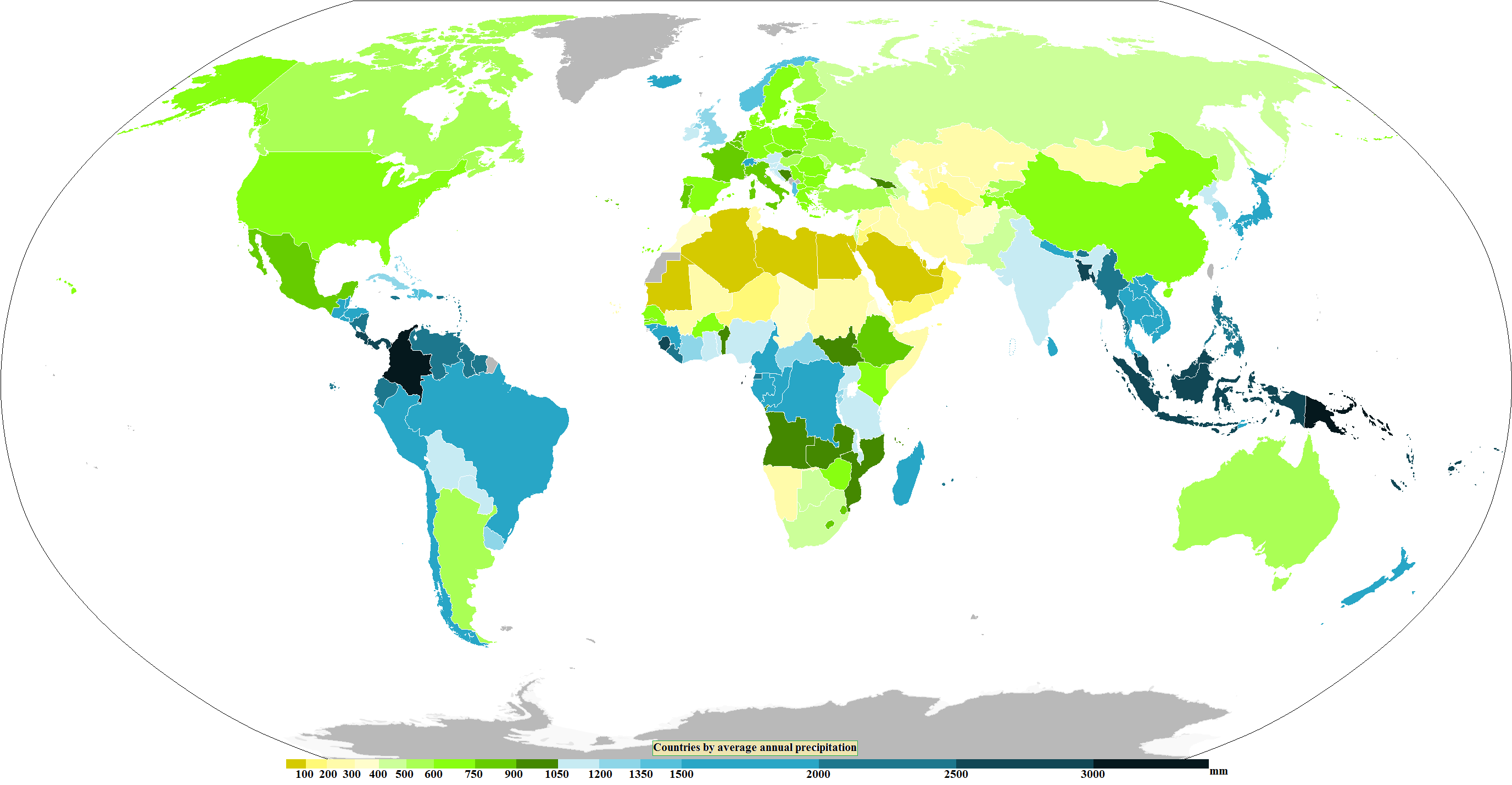
In meteorology, precipitation is any product of the condensation of atmospheric water vapor that falls from clouds due to gravitational pull. The main forms of precipitation include drizzle, rain, rain and snow mixed ("sleet" in Commonwealth usage), snow, ice pellets, graupel and hail. Precipitation occurs when a portion of the atmosphere becomes saturated with water vapor (reaching 100% relative humidity), so that the water condenses and "precipitates" or falls. Thus, fog and mist are not precipitation; their water vapor does not condense sufficiently to precipitate, so fog and mist do not fall. (Such a non-precipitating combination is a colloid.) Two processes, possibly acting together, can lead to air becoming saturated with water vapor: cooling the air or adding water vapor to the air. Precipitation forms as smaller droplets coalesce via collision with other rain drops or ice crystals within a cloud. Short, intense periods of rain in scattered locations are calle ... [...More Info...] [...Related Items...] OR: [Wikipedia] [Google] [Baidu] |
Cumulonimbus Cloud
Cumulonimbus () is a dense, towering, vertical cloud, typically forming from water vapor condensing in the lower troposphere that builds upward carried by powerful buoyant air currents. Above the lower portions of the cumulonimbus the water vapor becomes ice crystals, such as snow and graupel, the interaction of which can lead to hail and to lightning formation, respectively. When causing thunderstorms, these clouds may be called thunderheads. Cumulonimbus can form alone, in clusters, or along squall lines. These clouds are capable of producing lightning and other dangerous severe weather, such as tornadoes, hazardous winds, and large hailstones. Cumulonimbus progress from overdeveloped cumulus congestus clouds and may further develop as part of a supercell. Cumulonimbus is abbreviated as Cb. Description Towering cumulonimbus clouds are typically accompanied by smaller cumulus clouds. The cumulonimbus base may extend several kilometres (miles) across, or be a ... [...More Info...] [...Related Items...] OR: [Wikipedia] [Google] [Baidu] |
Precipitation Shaft
A precipitation shaft or rain shaft is a weather phenomenon, visible from the ground at large distances from the storm system, as a dark vertical shaft of heavy rain, hail, or snow, generally localized over a relatively small area. This is different from a virga, which is a shaft of precipitation that evaporates before reaching the ground. Formation A precipitation shaft is mostly found underneath convective clouds, such as cumulonimbus cloud or cumulus congestus cloud during a downpour storm, as these have well defined vertical drafts (updrafts and downdrafts) needed for heavy precipitation. However, an advancing nimbostratus cloud could have a diffuse precipitation leading edge, so its shaft may be unclear. Developing rain shafts often have a fuzzy, bulbous appearance as they descend. If a source of dry air is present at higher altitude and the air into which the rain is falling is sufficiently warm, then strong, possibly damaging microbursts are possible as sinking air f ... [...More Info...] [...Related Items...] OR: [Wikipedia] [Google] [Baidu] |
Heat Burst
In meteorology, a heat burst is a rare atmospheric phenomenon characterized by a sudden, localized increase in air temperature near the Earth's surface. Heat bursts typically occur during night-time and are associated with decaying thunderstorms. They are also characterized by extremely dry air and are sometimes associated with very strong, even damaging, winds. Although the phenomenon is not fully understood, the event is thought to occur when rain evaporates ( virga) into a parcel of cold, dry air high in the atmosphere, making the air denser than its surroundings. The parcel descends rapidly, warming due to compression, overshoots its equilibrium level, and reaches the surface, similar to a downburst. Recorded temperatures during heat bursts, as informally known as "Satan's Storm", have reached well above , sometimes rising by or more within only a few minutes. Characteristics In general, heat bursts occur during the late spring and summer seasons. During these times, a ... [...More Info...] [...Related Items...] OR: [Wikipedia] [Google] [Baidu] |
Downburst
In meteorology, a downburst is a strong downward and outward gushing wind system that emanates from a point source above and blows radially, that is, in straight lines in all directions from the area of impact at surface level. It originates under deep, moist convective conditions like cumulus congestus or cumulonimbus. Capable of producing damaging winds, it may sometimes be confused with a tornado, where high-velocity winds circle a central area, and air moves inward and upward. These usually last for seconds to minutes. Downbursts are particularly strong downdrafts within thunderstorms (or deep, moist convection as sometimes downbursts emanate from cumulonimbus or even cumulus congestus clouds that are not producing lightning). Downbursts are most often created by an area of significantly precipitation-cooled air that, after reaching the surface ( subsiding), spreads out in all directions producing strong winds. Dry downbursts are associated with thunderstorms that ex ... [...More Info...] [...Related Items...] OR: [Wikipedia] [Google] [Baidu] |
North Africa
North Africa (sometimes Northern Africa) is a region encompassing the northern portion of the African continent. There is no singularly accepted scope for the region. However, it is sometimes defined as stretching from the Atlantic shores of the Western Sahara in the west, to Egypt and Sudan's Red Sea coast in the east. The most common definition for the region's boundaries includes Algeria, Egypt, Libya, Morocco, Tunisia, and Western Sahara, the territory territorial dispute, disputed between Morocco and the list of states with limited recognition, partially recognized Sahrawi Arab Democratic Republic. The United Nations’ definition includes all these countries as well as Sudan. The African Union defines the region similarly, only differing from the UN in excluding the Sudan and including Mauritania. The Sahel, south of the Sahara, Sahara Desert, can be considered as the southern boundary of North Africa. North Africa includes the Spanish cities of Ceuta and Melilla, and the ... [...More Info...] [...Related Items...] OR: [Wikipedia] [Google] [Baidu] |
Nucleation Particle
Cloud condensation nuclei (CCNs), also known as cloud seeds, are small particles typically 0.2 μm, or one hundredth the size of a cloud droplet. CCNs are a unique subset of aerosols in the atmosphere on which water vapour condenses. This can affect the radiative properties of clouds and the overall atmosphere. Water vapour requires a non-gaseous surface to make the transition to a liquid; this process is called condensation. In the atmosphere of Earth, this surface presents itself as tiny solid or liquid particles called CCNs. When no CCNs are present, water vapour can be supercooled at about for 5–6 hours before droplets spontaneously form. This is the basis of the cloud chamber for detecting subatomic particles. The concept of CCN (must associate to a supersaturation ratio) is used in cloud seeding, which tries to encourage rainfall by seeding the air with condensation nuclei (CN, which does not associate to supersaturation ratio). It has further been suggested that cr ... [...More Info...] [...Related Items...] OR: [Wikipedia] [Google] [Baidu] |
Storm Cell
A storm cell is an air mass that contains up and down vertical draft, drafts in convective loops and that moves and reacts as a single entity, functioning as the smallest unit of a storm-producing system. An organized grouping of thunder clouds will thus be considered as a series of storm cells with their up/downdrafts being independent or interfering one with the other. Characteristics A storm cell can extend over an area the size of a few tens of square miles/kilometers and last 30 minutes or so. When the updraft and the environmental wind shear is well coordinated, the size and the duration of the cell can be much greater leading to a supercell. Finally, storm cells can form on the Outflow (meteorology), outflow of previous cells leading to multicellular thunderstorms or mesoscale convective systems. Slow motion of these more intense storm cells or groups of cells can produce large precipitation accumulations and flash flood, or other dangerous phenomena like hail and tornadoes ... [...More Info...] [...Related Items...] OR: [Wikipedia] [Google] [Baidu] |
Aviation
Aviation includes the activities surrounding mechanical flight and the aircraft industry. ''Aircraft'' include fixed-wing and rotary-wing types, morphable wings, wing-less lifting bodies, as well as lighter-than-air aircraft such as hot air balloons and airships. Aviation began in the 18th century with the development of the hot air balloon, an apparatus capable of atmospheric displacement through buoyancy. Clément Ader built the "Ader Éole" in France and made an uncontrolled, powered hop in 1890. This was the first powered aircraft, although it did not achieve controlled flight. Some of the most significant advancements in aviation technology came with the controlled gliding flying of Otto Lilienthal in 1896. A major leap followed with the construction of the '' Wright Flyer'', the first powered airplane by the Wright brothers in the early 1900s. Since that time, aviation has been technologically revolutionized by the introduction of the jet engine which enabl ... [...More Info...] [...Related Items...] OR: [Wikipedia] [Google] [Baidu] |


