|
Carolinia
The Carolina Terrane, also called the Carolina Superterrane or Carolinia, is an exotic terrane running ~ approximately North-South from central Georgia to central Virginia in the United States. It constitutes a major part of the eastern Piedmont Province. The terrane likely formed as a subduction-related volcanic island arc off the coast of South America (then Gondwana) during the Neoproterozoic to Early Cambrian (625–550 MYA). Plate tectonics moved it across the Iapetus Ocean until it docked with Laurentia (now the east coast of North America). The date of the docking is unknown, but could have occurred during the Taconic, Acadian, or Alleghanian Orogenies. The terrane comprises Neoproterozoic to Early Cambrian meta-sedimentary and meta-igneous rocks, intruded by later Paleozoic plutons. The protoliths of the meta-igneous rocks include mafic, intermediate, and felsic volcanics and plutons. These rocks underwent at least four metamorphic/deformation events, and so their or ... [...More Info...] [...Related Items...] OR: [Wikipedia] [Google] [Baidu] |
Cambrian
The Cambrian ( ) is the first geological period of the Paleozoic Era, and the Phanerozoic Eon. The Cambrian lasted 51.95 million years from the end of the preceding Ediacaran period 538.8 Ma (million years ago) to the beginning of the Ordovician Period 486.85 Ma. Most of the continents lay in the southern hemisphere surrounded by the vast Panthalassa Ocean. The assembly of Gondwana during the Ediacaran and early Cambrian led to the development of new convergent plate boundaries and continental-margin arc magmatism along its margins that helped drive up global temperatures. Laurentia lay across the equator, separated from Gondwana by the opening Iapetus Ocean. The Cambrian marked a profound change in life on Earth; prior to the Period, the majority of living organisms were small, unicellular and poorly preserved. Complex, multicellular organisms gradually became more common during the Ediacaran, but it was not until the Cambrian that fossil diversity seems to rapidly ... [...More Info...] [...Related Items...] OR: [Wikipedia] [Google] [Baidu] |
Ganderia
Ganderia or Gander Terrane (located near the town Gander, Newfoundland) is a terrane in the northern Appalachians which broke off the supercontinent Gondwana (Ma) together with Avalonia, Megumia, and Carolinia. Extent The microcontinent Avalonia broke off Gondwana in the Late Neoproterozoic together with a series of terranes that either formed its eastern coast or a separate block called Ganderia in front of it, if so separated from the Avalon Zone by the several hundred metres-wide Dover Fault. These terranes include the Early Palaeozoic siliciclastic rocks of the Gander Zone, the eastern passive margin of the Iapetus Ocean, now found in Newfoundland, New Brunswick, and New England, but they also include the contemporaneous or slightly older rocks of the Bras d'Or terrane in Cape Breton Island, the 550 Ma Upsalquitch gabbro, the Brookville and New River terranes in New Brunswick, and the Seven Hundred Acre Island in Maine. The Gander Zone also extends to the British Is ... [...More Info...] [...Related Items...] OR: [Wikipedia] [Google] [Baidu] |
Avalonia
Avalonia was a microcontinent in the Paleozoic era. Crustal fragments of this former microcontinent are terranes in parts of the eastern coast of North America: Atlantic Canada, and parts of the East Coast of the United States, East Coast of the United States. In addition, terranes derived from Avalonia also make up portions of Northwestern Europe, being found in England, Wales and parts of Ireland. Avalonia developed as a volcanic arc on the northern margin of Gondwana. It eventually rifted off, becoming a drifting microcontinent. The Rheic Ocean formed behind it, and the Iapetus Ocean shrank in front. It collided with the continents Baltica, then Laurentia. The Armorican terrane, Armorican Terrane assemblage collided with the merged Baltica/Avalonia during the formation of Pangea. When Pangea broke up, Avalonia's remains were divided by the rift which became the Atlantic Ocean. Avalonia is named for the Avalon Peninsula in Newfoundland (island), Newfoundland. When the term "A ... [...More Info...] [...Related Items...] OR: [Wikipedia] [Google] [Baidu] |
Farmington Gabbro Map Unit
Farmington may refer to: Places Canada *Farmington, British Columbia * Farmington, Nova Scotia (other) United States *Farmington, Arkansas *Farmington, California *Farmington, Connecticut *Farmington, Delaware * Farmington, Georgia * Farmington, Kentucky *Farmington (Louisville, Kentucky), listed on the National Register of Historic Places in Jefferson County, Kentucky *Hustonville, Kentucky, formerly known as Farmington * Kingsley, Kentucky, formerly known as Farmington *Farmington, Illinois * Farmington, Indiana *Farmington, Iowa *Farmington, Maine, a New England town ** Farmington (CDP), Maine, the main village in the town *Farmington, Michigan *Farmington, Minnesota *Farmington, Mississippi *Farmington, Missouri *Farmington, New Hampshire, a New England town **Farmington (CDP), New Hampshire, the main village in the town *Farmington, New Mexico *Farmington, New York *Farmington, North Carolina, a township and unincorporated community in Davie County, North Carolina ... [...More Info...] [...Related Items...] OR: [Wikipedia] [Google] [Baidu] |
Terranes
In geology, a terrane (; in full, a tectonostratigraphic terrane) is a crust fragment formed on a tectonic plate (or broken off from it) and accreted or " sutured" to crust lying on another plate. The crustal block or fragment preserves its distinctive geologic history, which is different from the surrounding areas—hence the term "exotic" terrane. The suture zone between a terrane and the crust it attaches to is usually identifiable as a fault. A sedimentary deposit that buries the contact of the terrane with adjacent rock is called an overlap formation. An igneous intrusion that has intruded and obscured the contact of a terrane with adjacent rock is called a stitching pluton. There is also an older usage of the term ''terrane'', which described a series of related rock formations or an area with a preponderance of a particular rock or rock group. Overview A tectonostratigraphic terrane did not necessarily originate as an independent microplate, since it may not contai ... [...More Info...] [...Related Items...] OR: [Wikipedia] [Google] [Baidu] |
Two Dogs Site
{{one source, date=September 2020 The Two Dogs Site (31PR92) is a lithic quarry site located in Person County, North Carolina.Seibel, Scott K"The Two Dogs Site (31PR92): A Middle Archaic and Woodland Period Lithic Quarry In Person County, North Carolina."''North Carolina Archaeology'', Vol. 58. 2009. This precontact archaeological site dates to the Middle Archaic and Woodland Periods, and it is classified as a lithic quarry site due to the presence of thousands of lithic artifacts found there. Located in the Carolina Slate Belt, the stone materials present at Two Dogs provided precontact Indigenous peoples with openly accessible lithic resources, predominantly for toolmaking, as they passed through the site between other, more residential areas. Two Dogs was excavated from 2004 to 2005 following shovel testing at the beginning of the decade. The lithic materials found at the Two Dogs Site were subjected to petrographic analysis, and isotopes were geochemically tested to confirm the ... [...More Info...] [...Related Items...] OR: [Wikipedia] [Google] [Baidu] |
Detrital Zircon Geochronology
Detrital zircon geochronology is the science of geochronology, analyzing the age of zircons deposited within a specific sedimentary rock, sedimentary unit by examining their inherent radioisotopes, most commonly the uranium–lead dating, uranium–lead ratio. Zircon is a common Accessory mineral, accessory or trace mineral constituent of most granite and felsic igneous rocks. Due to its hardness, durability and chemical inertness, zircon persists in sedimentary deposits and is a common constituent of most sands. Zircons contain trace amounts of uranium and thorium and can be dated using several modern analytical techniques. Detrital zircon geochronology has become increasingly popular in geological studies from the 2000s mainly due to the advancement in radiometric dating techniques. Detrital zircon age data can be used to constrain the maximum depositional age, determine provenance (geology), provenance, and reconstruct the tectonic setting on a regional scale. Detrital zirco ... [...More Info...] [...Related Items...] OR: [Wikipedia] [Google] [Baidu] |
Pelite
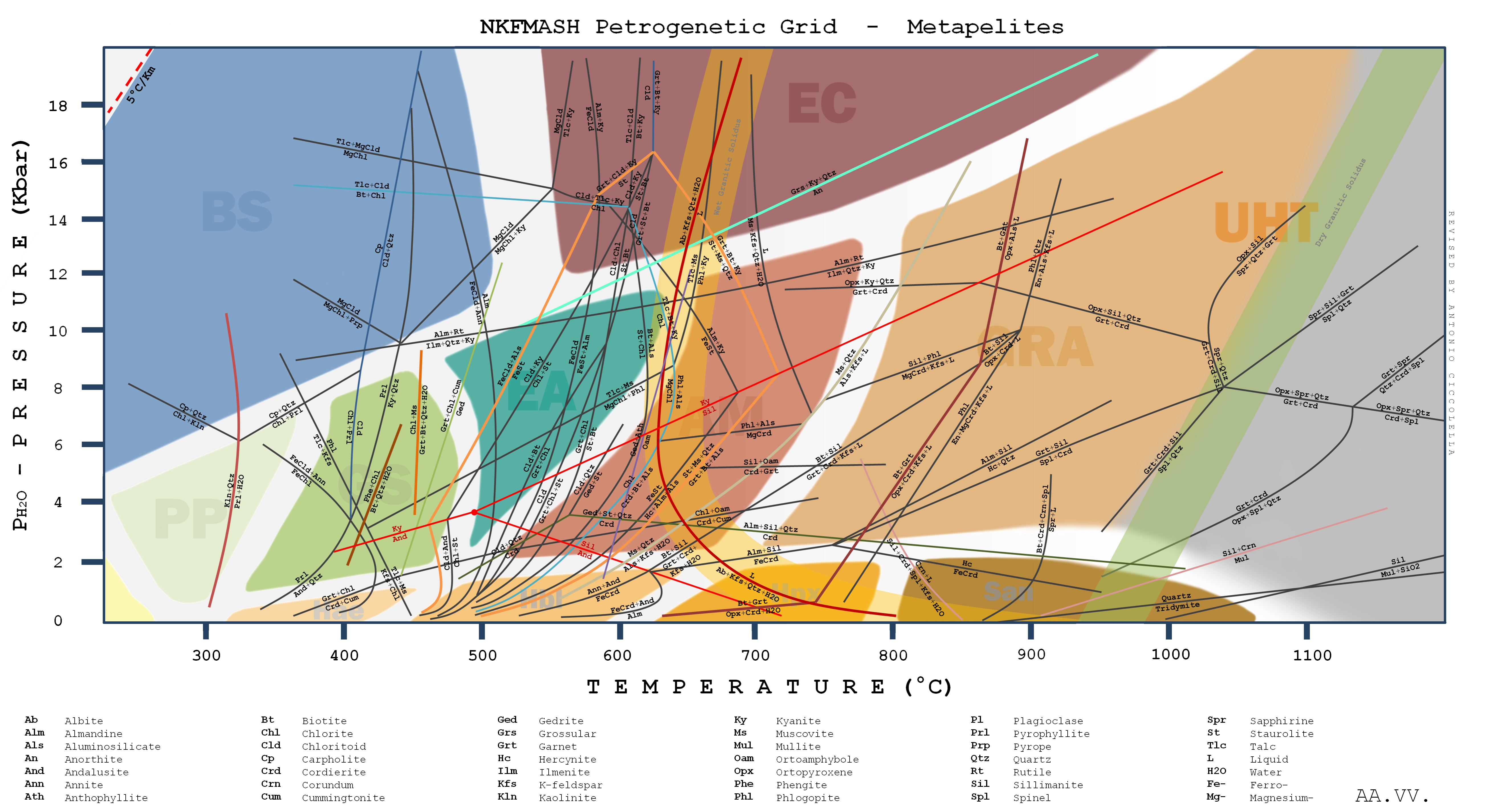
A pelite () or metapelite is a metamorphism, metamorphosed fine-grained sedimentary rock, i.e. mudstone or siltstone. The term was earlier used by geologists to describe a clay-rich, fine-grained clastic sediment or sedimentary rock, i.e. mud or a mudstone, the metamorphosed version of which would technically have been a ''metapelite''. It was equivalent to the now little-used Latin-derived term lutite.Potter, P.E., J.B. Maynard, and P.J. Depetris (2005) ''Muds and Mudstones.'' New York, New York, Springer. 279 pp. Neuendorf, K.K.E., J.P. Mehl, Jr., and J.A. Jackson, eds. (2005) ''Glossary of Geology'' (5th ed.). Alexandria, Virginia, American Geological Institute. 779 pp. A semipelite is defined in part as having similar chemical composition but being of a crystalloblastic nature. Francis J. Pettijohn, Pettijohn (1975) gives the following descriptive terms based on grain size, avoiding the use of terms such as clay or Argillite, argillaceous which carry an implication of chemic ... [...More Info...] [...Related Items...] OR: [Wikipedia] [Google] [Baidu] |
Greywacke
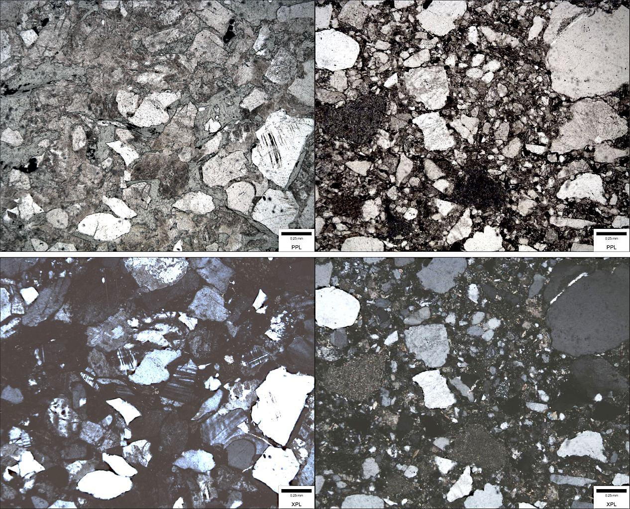
Greywacke or graywacke ( ) is a variety of sandstone generally characterized by its hardness (6–7 on Mohs scale), dark color, and Sorting (sediment), poorly sorted angular grains of quartz, feldspar, and small rock fragments or sand-size Lithic fragment (geology), lithic fragments set in a compact, clay-fine matrix. It is a texturally immature sedimentary rock generally found in Paleozoic Stratum, strata. The larger Particle size (grain size), grains can be sand- to gravel-sized, and Matrix (geology), matrix materials generally constitute more than 15% of the rock by volume. Formation The origin of greywacke was unknown until turbidity currents and turbidites were understood, since, according to the normal laws of sedimentation, gravel, sand and mud should not be laid down together. Geologists now attribute its formation to submarine avalanches or strong turbidity currents. These actions churn sediment and cause mixed-sediment slurries, in which the resulting deposits may ex ... [...More Info...] [...Related Items...] OR: [Wikipedia] [Google] [Baidu] |
Tugaloo Terrane
Tugaloo (''Dugiluyi'' (ᏚᎩᎷᏱ)) was a Cherokee town located on the Tugaloo River, at the mouth of Toccoa Creek. It was south of Toccoa and Travelers Rest State Historic Site in present-day Stephens County, Georgia, United States. Cultures of ancient indigenous peoples had occupied this area, and those of the South Appalachian Mississippian culture built a platform mound and village here. It was an administrative and ceremonial center for them. About six miles upriver was Estatoe, another historic Cherokee town in this area. (Other historic towns named Estatoe were identified in both western South Carolina and North Carolina.) Both the historic and prehistoric sites of Estatoe and Tugaloo were inundated by the creation of Lake Hartwell above Hartwell Dam. Etymology Tugaloo's proper name in Cherokee was ''Dugiluyi'' (ᏚᎩᎷᏱ); abbreviated to ''Dugilu'' (ᏚᎩᎷ). In English, it was phonetically spelled variously as Tugalo, Tugaloo, Toogelah, Toogoola, etc. Its ... [...More Info...] [...Related Items...] OR: [Wikipedia] [Google] [Baidu] |
Accretionary Wedge
An accretionary wedge or accretionary prism forms from sediments accreted onto the non- subducting tectonic plate at a convergent plate boundary. Most of the material in the accretionary wedge consists of marine sediments scraped off from the downgoing slab of oceanic crust, but in some cases the wedge includes the erosional products of volcanic island arcs formed on the overriding plate. An accretionary complex is a current (in modern use) or former accretionary wedge. Accretionary complexes are typically made up of a mix of turbidites of terrestrial material, basalts from the ocean floor, and pelagic and hemipelagic sediments. For example, most of the geological basement of Japan is made up of accretionary complexes. Materials within an accretionary wedge Accretionary wedges and accreted terranes are not equivalent to tectonic plates, but rather are associated with tectonic plates and accrete as a result of tectonic collision. Materials incorporated in accretionary wedge ... [...More Info...] [...Related Items...] OR: [Wikipedia] [Google] [Baidu] |
Slab Rollback
Oceanic trenches are prominent, long, narrow topographic depressions of the ocean floor. They are typically wide and below the level of the surrounding oceanic floor, but can be thousands of kilometers in length. There are about of oceanic trenches worldwide, mostly around the Pacific Ocean, but also in the eastern Indian Ocean and a few other locations. The greatest ocean depth measured is in the Challenger Deep of the Mariana Trench, at a depth of below sea level. Oceanic trenches are a feature of the Earth's distinctive plate tectonics. They mark the locations of convergent plate boundaries, along which lithospheric plates move towards each other at rates that vary from a few millimeters to over ten centimeters per year. Oceanic lithosphere moves into trenches at a global rate of about per year. A trench marks the position at which the flexed, subducting slab begins to descend beneath another lithospheric slab. Trenches are generally parallel to and about from a volcan ... [...More Info...] [...Related Items...] OR: [Wikipedia] [Google] [Baidu] |


