|
Bilsdale
Bilsdale is a Dale (landform), dale in the western part of the North York Moors in North Yorkshire, England. The head of the dale is at Hasty Bank, and the dale extends south to meet Rye Dale near Hawnby. The dale is the valley of the River Seph, formed where Raisdale Beck joins Bilsdale Beck at the small village of Chop Gate in the north of the dale. The river flows south to meet the River Rye at Seph Mouth. The dale is divided between two civil parishes. The upper part of the dale comprises the civil parish of Bilsdale Midcable and the lower part of the dale is in the civil parish of Hawnby. History The place-name is derived from an Old Norse personal name ''Bildr'', and so means "Bildr's valley". In the 12th century the northern part of the dale was granted to Kirkham Priory, and the southern part to Rievaulx Abbey. Bilsdale Rievaulx was itself divided by the River Seph. The part to the west of the river became the township of Bilsdale Westside in the parish of Ha ... [...More Info...] [...Related Items...] OR: [Wikipedia] [Google] [Baidu] |
Bilsdale Transmitting Station
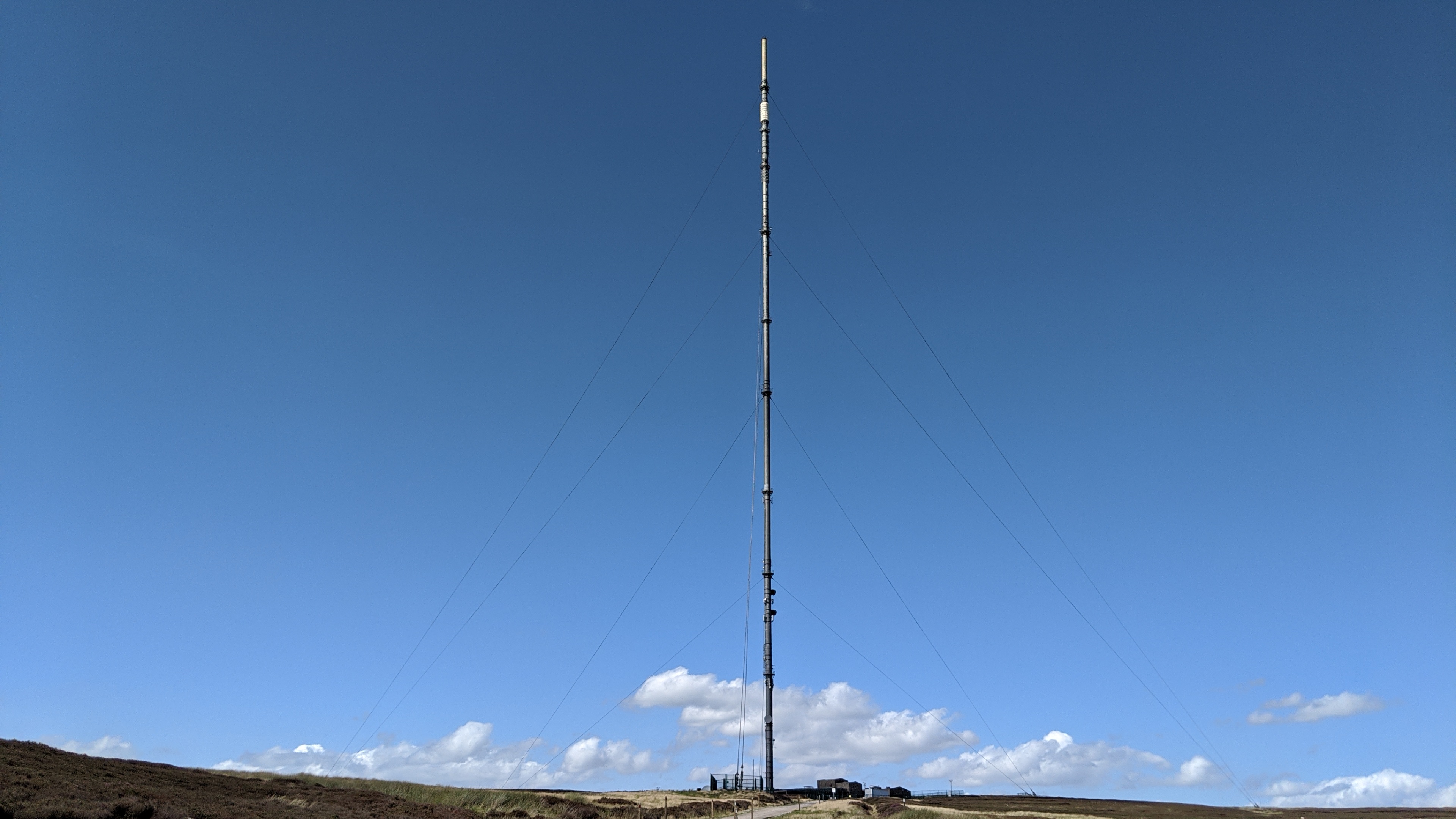
The Bilsdale transmitting station is a broadcasting and telecommunications facility, located at Bilsdale West Moor above Bilsdale, close to Helmsley, North Yorkshire, England. The original facility included a Radio masts and towers#Tubular steel, guyed steel tubular mast that was primarily used for radio and television transmission. The height of the mast was to the pinnacle. Until a fire disabled the transmitter on 10 August 2021 it was among the most powerful transmitters in the UK. The power for analogue was 500 kW effective radiated power, ERP and it was 100 kW / 50 kW for digital. The mast was equipped with aircraft warning lights, in the form of arrays of red Light-emitting diode, LEDs. The station was owned and operated by Arqiva. After the main mast was disabled a temporary mast was installed at the site. The temporary mast commenced operations on 13 October 2021. History Original mast (1969–2021) Bilsdale was constructed by J. L. Eve Construction for the BBC ... [...More Info...] [...Related Items...] OR: [Wikipedia] [Google] [Baidu] |
Bilsdale
Bilsdale is a Dale (landform), dale in the western part of the North York Moors in North Yorkshire, England. The head of the dale is at Hasty Bank, and the dale extends south to meet Rye Dale near Hawnby. The dale is the valley of the River Seph, formed where Raisdale Beck joins Bilsdale Beck at the small village of Chop Gate in the north of the dale. The river flows south to meet the River Rye at Seph Mouth. The dale is divided between two civil parishes. The upper part of the dale comprises the civil parish of Bilsdale Midcable and the lower part of the dale is in the civil parish of Hawnby. History The place-name is derived from an Old Norse personal name ''Bildr'', and so means "Bildr's valley". In the 12th century the northern part of the dale was granted to Kirkham Priory, and the southern part to Rievaulx Abbey. Bilsdale Rievaulx was itself divided by the River Seph. The part to the west of the river became the township of Bilsdale Westside in the parish of Ha ... [...More Info...] [...Related Items...] OR: [Wikipedia] [Google] [Baidu] |
River Seph
The River Seph (or River Sep) is a tributary of the River Rye (itself a tributary of the River Derwent) in North Yorkshire, England. The river flows for down Bilsdale and meets the Rye near the village of Hawnby. When the surrounding land was owned by Roger de Mowbray, the river was referred to as the ''Sep''. Name Common club-rush ('' Schoenoplectus lacustris'') prefers to grow in shallow water such as that found in ponds, streams and river margins. During the medieval period sedges and rushes were known as " ''seaves'' ", hence the origin of the name ''Seave Green'' near Chop Gate at the head of Bilsdale. The name ''Seph'' derives from Old Norse ''sef'' – " sedge, rush ". The meaning for ''River Seph'' might be: # Slow Stream or Calm. # River where seaves grow. # River overgrown with seaves. Examples of rivers that might share a similar etymology: * River Severn (Welsh: Afon Hafren) (''Sephern'' – 1479). * River Seven, Rosedale, North York Moors. Course The ... [...More Info...] [...Related Items...] OR: [Wikipedia] [Google] [Baidu] |
Bilsdale Midcable
Bilsdale Midcable is a civil parish in North Yorkshire, England, which occupies the northern part of Bilsdale in the North York Moors National Park. According to the 2001 census it had a population of 293 increasing to 332 at the 2011 Census. Settlements in the parish are The Grange, Chop Gate (locally pron "Chop Yat"), Seave Green and Urra. The parish also contains Bilsdale Moor, East and West. From 1974 to 2023 it was part of the district of Hambleton, it is now administered by the unitary North Yorkshire Council North Yorkshire Council, known between 1974 and 2023 as North Yorkshire County Council, is the local authority for the non-metropolitan county of North Yorkshire, England. Since 2023 the council has been a unitary authority, being a county coun .... See also * Listed buildings in Bilsdale Midcable References Civil parishes in North Yorkshire Bilsdale {{NorthYorkshire-geo-stub ... [...More Info...] [...Related Items...] OR: [Wikipedia] [Google] [Baidu] |
Helmsley
Helmsley is a market town and civil parish in North Yorkshire, England. Historically part of the North Riding of Yorkshire, the town is located at the point where Ryedale leaves the moorland and joins the flat Vale of Pickering. Helmsley is situated on the River Rye on the A170 road, east of Thirsk, west of Pickering and some due north of York. The southern boundary of the North York Moors National Park passes through Helmsley along the A170 road so that the western part of the town is within the National Park. The settlement grew around its position at a road junction and river crossing point. Helmsley is a compact town, retaining its medieval layout around its market place with more recent development to the north and south of its main thoroughfare, Bondgate. It is a historic town of considerable architectural character whose centre has been designated as a conservation area. The town is associated with the Earls of Feversham, whose ancestral home Duncombe Park wa ... [...More Info...] [...Related Items...] OR: [Wikipedia] [Google] [Baidu] |
North York Moors
The North York Moors is an upland area in north-eastern Yorkshire, England. It contains one of the largest expanses of Calluna, heather moorland in the United Kingdom. The area was designated as a national parks of England and Wales, National Park in 1952, through the National Parks and Access to the Countryside Act 1949. Covering an area of , the National Park has a population of 23,380. It is administered by the North York Moors National Park Authority, which is based in Helmsley. Location and transport To the east, the area is clearly defined by the impressive cliffs of the North Sea coast. The northern and western boundaries are defined by the steep scarp slopes of the Cleveland Hills edging the Tees lowlands and the Hambleton Hills above the Vale of Mowbray. To the south lies the broken line of the Tabular Hills and the Vale of Pickering. Four roads cross the North York Moors from north to south. In the east, the A171 road, A171 joins Whitby and Scarborough, North Yorkshi ... [...More Info...] [...Related Items...] OR: [Wikipedia] [Google] [Baidu] |
North Yorkshire
North Yorkshire is a Ceremonial counties of England, ceremonial county in Northern England.The Unitary authorities of England, unitary authority areas of City of York, York and North Yorkshire (district), North Yorkshire are in Yorkshire and the Humber, and Borough of Middlesbrough, Middlesbrough, Redcar and Cleveland, and Stockton-on-Tees Borough Council, Stockton-on-Tees are in North East England. It borders County Durham to the north, the North Sea to the east, the East Riding of Yorkshire to the south-east, South Yorkshire to the south, West Yorkshire to the south-west, and Cumbria and Lancashire to the west. The county is the largest in England by land area, at , and had a population of 1,158,816 in 2021. The largest settlements are Middlesbrough (148,215) in the north-east and the city of York (141,685) in the south. Middlesbrough is part of the Teesside built-up area, which extends into County Durham and had a total population of 376,663 in 2011. The remainder of the cou ... [...More Info...] [...Related Items...] OR: [Wikipedia] [Google] [Baidu] |
Chop Gate
Chop Gate ( ) is a small village in the North York Moors national park, North Yorkshire, England. Historically part of the North Riding of Yorkshire The North Riding of Yorkshire was a subdivision of Yorkshire, England, alongside York, the East Riding and West Riding. The riding's highest point was at Mickle Fell at . From the Restoration it was used as a lieutenancy area, having b ..., the village is situated south east of Stokesley and north of Helmsley. From 1974 to 2023 it was part of the district of Hambleton, it is now administered by the unitary North Yorkshire Council. The village is at the point where the roads to Bilsdale and Raindale meet. Chop Gate is on the B1257 road between Helmsley and Stokesley. Chop Gate's name probably comes from the Old Norse word 'koppr' meaning 'hill' and 'gata' which means 'road'. Religion St Hilda's Anglican Church St Hilda's Anglican church, in Chop Gate, which opened in 1853, is between the hamlets of Urra and Seav ... [...More Info...] [...Related Items...] OR: [Wikipedia] [Google] [Baidu] |
Laskill
Laskill is a small hamlet in Bilsdale, 5 miles (8 km) north-west of Helmsley, North Yorkshire, England, on the road from Helmsley to Stokesley and is located within the North York Moors National Park. Archaeological investigations have revealed that the Cistercian monks of the nearby Rievaulx Abbey had a large woolhouse there, dating from the middle of the 13th century. The Cistercian monks, known to have been skilled metallurgists, also had a blast furnace (the only medieval example yet identified in Britain) for the smelting of iron ore into cast iron. The iron ore left in the slag at Laskill has been identified by Gerry McDonnell (archeometallurgist of the University of Bradford) as more refined than anything else at the time, suggesting a much more efficient blast furnace technology than otherwise existed – perhaps as advanced as a modern blast furnace. The destruction of the abbey at Rievaulx by King Henry VIII during the Reformation put an end to this b ... [...More Info...] [...Related Items...] OR: [Wikipedia] [Google] [Baidu] |
Jet (lignite)
Jet, Jets, or The Jet(s) may refer to: Aerospace * Jet aircraft, an aircraft propelled by jet engines ** Jet airliner ** Jet engine ** Jet fuel * Jet Airways, an Indian airline * Super Air Jet, an Indonesian airline * Wind Jet (ICAO: JET), an Italian airline * Journey to Enceladus and Titan (JET), a proposed astrobiology orbiter to Saturn * Jet pack, a backpack personal flying device containing a jet motor * Fighter jet, a military aircraft Aircraft * Business jet ** Boeing Business Jet * Very light jet ** Cirrus Vision SF50, originally called "The-Jet by Cirrus" ** Eclipse 400, originally called "Eclipse Concept Jet" ** Honda HA-420 HondaJet ** Piper PA-47 PiperJet Other areas of science, math, and technology * Jet (fluid), a coherent stream of fluid that is projected into a surrounding medium, usually from some kind of a nozzle or aperture * Jet (gemstone), a black or brown semi-precious mineraloid * Jet (mathematics), an operation on a differentiable function ... [...More Info...] [...Related Items...] OR: [Wikipedia] [Google] [Baidu] |
Baron Feversham
Baron Feversham is a title that has been created twice, once in the Peerage of Great Britain and once in the Peerage of the United Kingdom. The first creation, in the Peerage of Great Britain, came in 1747 when Anthony Duncombe, who had earlier represented Salisbury and Downton in the House of Commons, was made Lord Feversham, Baron of Downton, in the County of Wilts. He had previously inherited half of the enormous fortune of his uncle Sir Charles Duncombe. However, Lord Feversham had no sons and the barony became extinct on his death in 1763. The peerage was revived in the Peerage of the United Kingdom in 1826 in favour of his kinsman Charles Duncombe, who was created Baron Feversham, of Duncombe Park in the County of York. He was a former Member of Parliament for Shaftesbury, Aldborough, Heytesbury and Newport. Duncombe was the grandson of Thomas Duncombe, son of John Brown (who assumed the surname Duncombe) by his wife Ursula Duncombe, aunt of the first Baron of t ... [...More Info...] [...Related Items...] OR: [Wikipedia] [Google] [Baidu] |
Thomas Manners, 1st Earl Of Rutland
Thomas Manners, 1st Earl of Rutland, 12th Baron de Ros of Helmsley, Order of the Garter, KG (c. 1497{{snd20 September 1543), of Belvoir Castle in Leicestershire (adjacent to the small county of Rutland), was created Earl of Rutland by King Henry VIII of England, Henry VIII in 1525. Origins Thomas was the son of Sir George Manners, 11th Baron de Ros (c. 1470{{snd1513) by his wife Anne St Leger (1476–1526). His maternal grandparents were Sir Thomas St Leger (c. 1440–1483) and Anne of York, Duchess of Exeter, Anne of York (1439–1476), a daughter of Richard Plantagenet, 3rd Duke of York and Cecily Neville. She was thus an elder sister of Kings Edward IV of England, Edward IV (1461–1483) and of his brother and eventual successor, Richard III of England, Richard III (1483–1485). Her other brothers were Edmund, Earl of Rutland and George Plantagenet, 1st Duke of Clarence. Her sisters included Elizabeth of York, Duchess of Suffolk and Margaret of York. Anne St Leger's first cous ... [...More Info...] [...Related Items...] OR: [Wikipedia] [Google] [Baidu] |


