|
Beyond Capricorn
''Beyond Capricorn: How Portuguese adventurers secretly discovered and mapped Australia and New Zealand 250 years before Captain Cook'' is a 2007 book by journalist Peter Trickett on the theory of Portuguese discovery of Australia. Although its thesis is similar to that advanced by Kenneth McIntyre in 1977, Lawrence Fitzgerald in 1984 and others, the publisher and some news reports presented it as being a new theory on the discovery of Australia. Historical scholars, including Flinders University Associate Professor Bill Richardson,Richardson, W.A.R. ''Yet Another Version of the Portuguese 'Discovery' of Australia'' nline "The Globe",Issue 59; 2007; pp. 59–60. Availability. ited 9 Jan 09/ref> generally reject the premise on which the book is based, pointing out that only circumstantial evidence has been presented which supports the theory.''Agora'', Vol 42, No. 2, 2007. Journal of the History Teacher's Association of Victoria. Book reviews, P.64. The book has been translate ... [...More Info...] [...Related Items...] OR: [Wikipedia] [Google] [Baidu] |
Theory Of Portuguese Discovery Of Australia
The theory of Portuguese discovery of Australia claims that early Portuguese navigators were the first Europeans to sight Australia between 1521 and 1524, well before the arrival of Dutch navigator Willem Janszoon in 1606 on board the who is generally considered to be the first European discoverer. While lacking generally accepted evidence, this theory is based on the following: * The Dieppe maps, a group of 16th-century French world maps, depict a large landmass between Indonesia and Antarctica. Labelled as Java la Grande, this landmass carries French, Portuguese, and Gallicized Portuguese placenames, and has been interpreted by some as corresponding to Australia's northwestern and eastern coasts. * The proximity of Portuguese colonies in Southeast Asia from , particularly Portuguese Timor which is approximately from the Australian coast. * Various antiquities found on Australian coastlines, claimed by some to be relics of early Portuguese voyages to Australia but whi ... [...More Info...] [...Related Items...] OR: [Wikipedia] [Google] [Baidu] |
Vallard Atlas
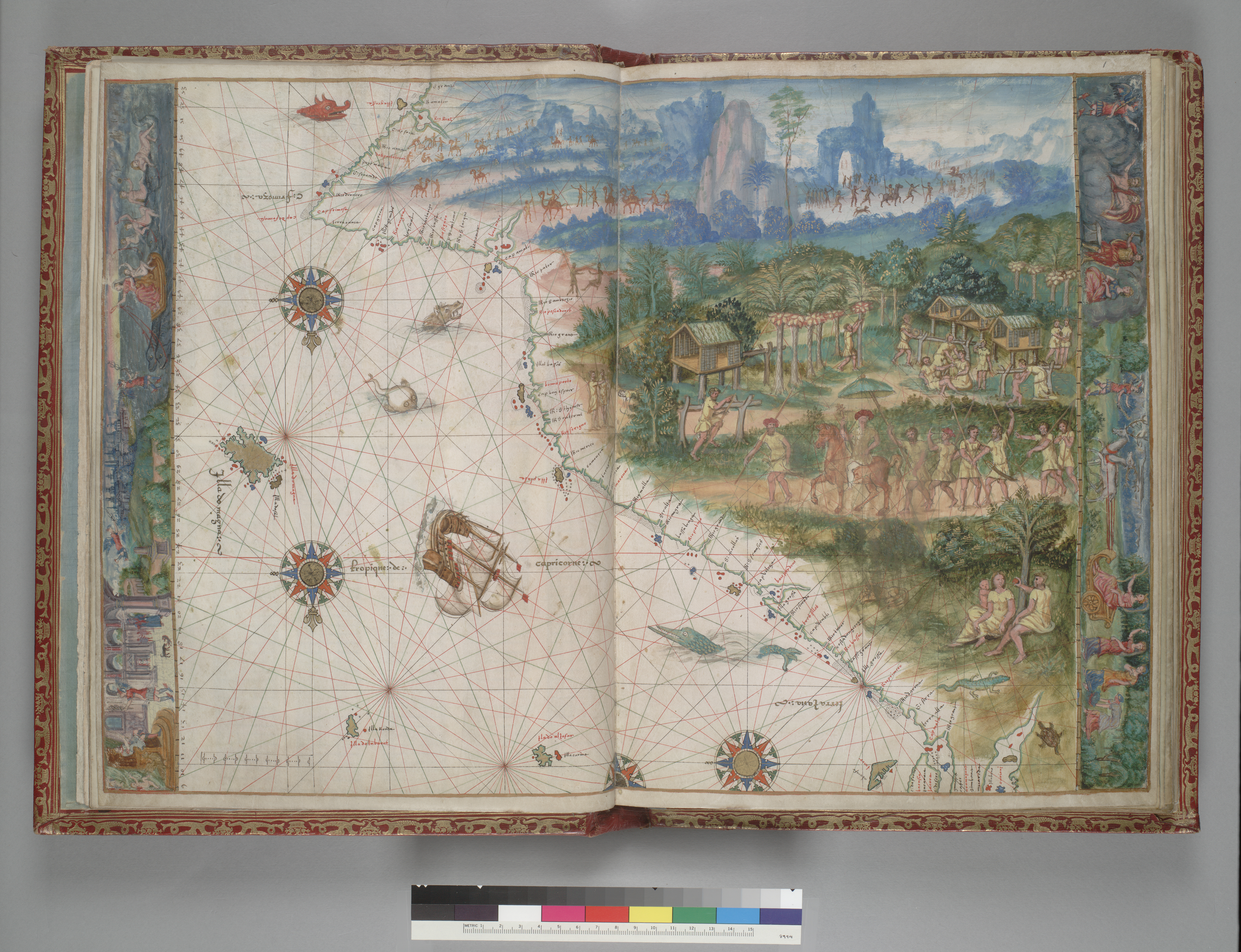
The Vallard Atlas is a world atlas, one of the Dieppe school of maps, produced in 1547. It is believed to have been owned by Nicolas Vallard, its authorship being unknown. History It is considered one of the most notable 16th-century atlases of the Dieppe school of Cartography. It is believed that Nicholas Vallard was the first owner and this is why the publication bears his name The atlas is held at the Huntington Library based in San Marino, California, USA. Description The atlas consists of 68 pages, and contains 15 nautical charts with rich illustrations as well as a calendar and some in-depth maritime information. The atlas contains numerous illuminations that show the New World’s inhabitants, and this is why it is considered a valuable testimony of discovery. The original publication is bound in crimson leather with golden decorations. The maps depicted in the atlas are inverted compared to modern depictions, as the North Pole is placed on the bottom side o ... [...More Info...] [...Related Items...] OR: [Wikipedia] [Google] [Baidu] |
Sydney Airport
Sydney Kingsford Smith Airport (colloquially Mascot Airport, Kingsford Smith Airport, or Sydney Airport; ; ) is an international airport in Sydney, Australia, located 8 km (5 mi) south of the Sydney central business district, in the suburb of Mascot. The airport is owned by Sydney Airport Holdings. It is the primary airport serving Sydney, and is a primary hub for Qantas, as well as a secondary hub for Virgin Australia and Jetstar, as well as a focus city for Air New Zealand. Situated next to Botany Bay, the airport has three runways. Sydney Airport is one of the world's longest continuously operated commercial airports and is the busiest airport in Australia, handling 42.6 million passengers and 348,904 aircraft movements in 2016–17. It was the 38th busiest airport in the world in 2016. Currently 46 domestic and 43 international destinations are served to Sydney directly. In 2018, the airport was rated in the top five worldwide for airports handling 40– ... [...More Info...] [...Related Items...] OR: [Wikipedia] [Google] [Baidu] |
Botany Bay Vallard
Botany, also called plant science (or plant sciences), plant biology or phytology, is the science of plant life and a branch of biology. A botanist, plant scientist or phytologist is a scientist who specialises in this field. The term "botany" comes from the Ancient Greek word (') meaning "pasture", "herbs" "grass", or "fodder"; is in turn derived from (), "to feed" or "to graze". Traditionally, botany has also included the study of fungi and algae by mycologists and phycologists respectively, with the study of these three groups of organisms remaining within the sphere of interest of the International Botanical Congress. Nowadays, botanists (in the strict sense) study approximately 410,000 species of land plants of which some 391,000 species are vascular plants (including approximately 369,000 species of flowering plants), and approximately 20,000 are bryophytes. Botany originated in prehistory as herbalism with the efforts of early humans to identify – and later culti ... [...More Info...] [...Related Items...] OR: [Wikipedia] [Google] [Baidu] |
New South Wales
) , nickname = , image_map = New South Wales in Australia.svg , map_caption = Location of New South Wales in AustraliaCoordinates: , subdivision_type = Country , subdivision_name = Australia , established_title = Before federation , established_date = Colony of New South Wales , established_title2 = Establishment , established_date2 = 26 January 1788 , established_title3 = Responsible government , established_date3 = 6 June 1856 , established_title4 = Federation , established_date4 = 1 January 1901 , named_for = Wales , demonym = , capital = Sydney , largest_city = capital , coordinates = , admin_center = 128 local government areas , admin_center_type = Administration , leader_title1 = Monarch , leader_name1 = Charles III , leader_title2 = Governor , leader_name2 = Margaret Beazley , leader_title3 = Premier , leader_name3 = Dominic Perrottet ( Liberal) , national_representation = Parliament of Australia , national_representation_type1 = Sen ... [...More Info...] [...Related Items...] OR: [Wikipedia] [Google] [Baidu] |
Bittangabee Bay
Bittangabee Bay is a tiny, picturesque bay on the rugged and remote stretch of coastline south of Eden in New South Wales, Australia. The bay is located in Beowa National Park, and there is a campground nearby. The facilities are maintained by National Parks and Wildlife Service (NPWS), Merimbula office. It can be reached by an unsealed road from the Princes Highway. The bay is the only haven between Twofold Bay and Mallacoota Inlet, and passing yachts are seen anchored for the night there most evenings. It is fed by Bittangabee Creek. History Bittangabee Bay was significant for the indigenous people of the region, and early European settlement. Bittangabee Bay was known as 'Pertangerbee' by the original occupants of the area, the Thaua/Thawa/Thauaira people of the Yuin ( Murring) nation, who have lived there for over 6,000 years. [...More Info...] [...Related Items...] OR: [Wikipedia] [Google] [Baidu] |
Portolan Chart
Portolan charts are nautical charts, first made in the 13th century in the Mediterranean basin and later expanded to include other regions. The word ''portolan'' comes from the Italian ''portulano'', meaning "related to ports or harbors", and which since at least the 17th century designates "a collection of sailing directions". Definition The term “portolan chart” was coined in the 1890s because at the time it was assumed that these maps were related to portolani, medieval or early modern books of sailing directions. Other names that have been proposed include rhumb line charts, compass charts or loxodromic charts whereas modern French scholars prefer to call them nautical charts to avoid any relationship with portolani. Several definitions of portolan chart coexist in the literature. A narrow definition includes only medieval or, at the latest, early modern sea charts (i.e. maps that primarily cover maritime rather than inland regions) that include a network of rhum ... [...More Info...] [...Related Items...] OR: [Wikipedia] [Google] [Baidu] |
Western Australia
Western Australia (commonly abbreviated as WA) is a state of Australia occupying the western percent of the land area of Australia excluding external territories. It is bounded by the Indian Ocean to the north and west, the Southern Ocean to the south, the Northern Territory to the north-east, and South Australia to the south-east. Western Australia is Australia's largest state, with a total land area of . It is the second-largest country subdivision in the world, surpassed only by Russia's Sakha Republic. the state has 2.76 million inhabitants percent of the national total. The vast majority (92 percent) live in the south-west corner; 79 percent of the population lives in the Perth area, leaving the remainder of the state sparsely populated. The first Europeans to visit Western Australia belonged to the Dutch Dirk Hartog expedition, who visited the Western Australian coast in 1616. The first permanent European colony of Western Australia occurred following ... [...More Info...] [...Related Items...] OR: [Wikipedia] [Google] [Baidu] |
North Island Of New Zealand
The North Island, also officially named Te Ika-a-Māui, is one of the two main islands of New Zealand, separated from the larger but much less populous South Island by the Cook Strait. The island's area is , making it the world's 14th-largest island. The world's 28th-most-populous island, Te Ika-a-Māui has a population of accounting for approximately % of the total residents of New Zealand. Twelve main urban areas (half of them officially cities) are in the North Island. From north to south, they are Whangārei, Auckland, Hamilton, Tauranga, Rotorua, Gisborne, New Plymouth, Napier, Hastings, Whanganui, Palmerston North, and New Zealand's capital city Wellington, which is located at the south-west tip of the island. Naming and usage Although the island has been known as the North Island for many years, in 2009 the New Zealand Geographic Board found that, along with the South Island, the North Island had no official name. After a public consultation, the board of ... [...More Info...] [...Related Items...] OR: [Wikipedia] [Google] [Baidu] |
Malacca
Malacca ( ms, Melaka) is a state in Malaysia located in the southern region of the Malay Peninsula, next to the Strait of Malacca. Its capital is Malacca City, dubbed the Historic City, which has been listed as a UNESCO World Heritage Site since 7 July 2008. The state is bordered by Negeri Sembilan to the north and west and Johor to the south. The exclave of Tanjung Tuan also borders Negeri Sembilan to the north. Its capital Malacca City is southeast of Malaysia's capital city Kuala Lumpur, northwest of Johor's largest city Johor Bahru and northwest of Johor's second largest city, Batu Pahat. Although it was the location of one of the earliest Malay sultanates, namely the Malacca Sultanate, the local monarchy was abolished when the Portuguese conquered it in 1511. The head of state is the '' Yang di-Pertua Negeri'' or Governor, rather than a Sultan. Malacca is noted for its unique history and it is one of the major tourist destinations in Malaysia. With a highl ... [...More Info...] [...Related Items...] OR: [Wikipedia] [Google] [Baidu] |


