|
Aggijjat
Aggijjat (Inuktitut syllabics: ''ᐊᒡᒋᔾᔭᑦ'') formerly Durban Island is a Canadian Arctic island located in Nunavut, Canada. It is one of Baffin Island's northeast offshore islands within Davis Strait's Merchants Bay. It is in size. Durban Harbour is on the island's southeast facing side. Nearby can be found the larger Paallavvik, and Auyuittuq National Park is also to the west on Baffin Island. History Durban Island (FOX-E) is a former Distant Early Warning Line and is currently a North Warning System site. It is listed by the Contaminated Sites Directorate in Iqaluit Iqaluit is the capital of the Canadian territory of Nunavut. It is the territory's largest community and its only city, and the northernmost city in Canada. It was known as Frobisher Bay from 1942 to 1987, after the large bay on the coast on ... as a contaminated site in need of future remediation. References Islands of Baffin Island Islands of Davis Strait Uninhabited islands of Qikiqt ... [...More Info...] [...Related Items...] OR: [Wikipedia] [Google] [Baidu] |
Paallavvik
Paallavvik (Inuktitut syllabics: ''ᐹᓪᓚᕝᕕᒃ'', ''Paallavvik'' means 'the place where one stumbles', from ''paallat'' 'to stumble' + -''vik'' 'place for X-ing', or ''paallakpuq'' 'to fall down (forward), trip, fall forward') formerly Padloping Island is an uninhabited island in the Qikiqtaaluk Region of Nunavut, Canada. It is located in Merchants Bay, just to the south of Davis Strait, and off the eastern coast of Baffin Island. The smaller Aggijjat (formerly Durban Island) is approximately to the east, while Auyuittuq National Park is to the west. Geography It measures long, by wide. History Padloping was originally an Inuit community on the island by the same name. In July 1941, a United States Army Air Forces (USAAF) team headed by Captain Elliott Roosevelt conducted aerial reconnaissance for an airport site in the region of Baffin Island closest to Greenland. Roosevelt selected the southern edge of Paallavvik as the most promising, there being no better places ... [...More Info...] [...Related Items...] OR: [Wikipedia] [Google] [Baidu] |
Davis Strait
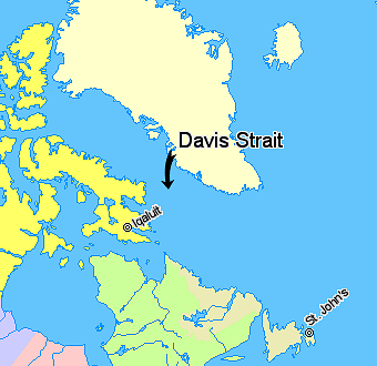
The Davis Strait (Danish language, Danish: ''Davisstrædet'') is a southern arm of the Arctic Ocean that lies north of the Labrador Sea. It lies between mid-western Greenland and Baffin Island in Nunavut, Canada. To the north is Baffin Bay. The strait was named for the English explorer John Davis (English explorer), John Davis (1550–1605), who explored the area while seeking a Northwest Passage. By the 1650s it was used for whaling, whale hunting. Extent The International Hydrographic Organization defines the limits of the Davis Strait as follows: ''On the North.'' The Southern limit of Baffin Bay [The parallel of 70th parallel north, 70° North between Greenland and Baffin Island, Baffin Land]. ''On the East.'' The Southwest coast of Greenland. ''On the South.'' The parallel of 60th parallel north, 60° North between Greenland and Labrador. ''On the West.'' The Eastern limit of the Northwest Passage, Northwestern Passages South of 70° North [the East coast of Baffin Islan ... [...More Info...] [...Related Items...] OR: [Wikipedia] [Google] [Baidu] |
Arctic Archipelago
The Arctic Archipelago, also known as the Canadian Arctic Archipelago, is an archipelago lying to the north of the Canadian continental mainland, excluding Greenland (an autonomous territory of the Danish Realm, which is, by itself, much larger than the combined area of the archipelago) and Iceland (an independent country). Situated in the northern extremity of North America and covering about , this group of 36,563 islands, surrounded by the Arctic Ocean, comprises much of Northern Canada, predominately Nunavut and the Northwest Territories. The archipelago is showing some effects of climate change, with some computer estimates determining that melting there will contribute to the rise in sea levels by 2100. History Around 2500 BCE, the first humans, the Paleo-Eskimos, arrived in the archipelago from the Canadian mainland. Between 1000 and 1500 CE, they were replaced by the Thule people, who are the ancestors of today's Inuit. British claims on the islands, the British A ... [...More Info...] [...Related Items...] OR: [Wikipedia] [Google] [Baidu] |
Provinces And Territories Of Canada
Canada has ten provinces and three territories that are sub-national administrative divisions under the jurisdiction of the Constitution of Canada, Canadian Constitution. In the 1867 Canadian Confederation, three provinces of British North America—New Brunswick, Nova Scotia, and the Province of Canada (which upon Confederation was divided into Ontario and Quebec)—united to form a federation, becoming a fully Independence, independent country over the next century. Over its history, Canada's international borders have changed several times as it has added territories and provinces, making it the List of countries and dependencies by area, world's second-largest country by area. The major difference between a Canadian province and a territory is that provinces receive their power and authority from the ''Constitution Act, 1867'' (formerly called the ''British North America Acts, British North America Act, 1867''), whereas territories are federal territories whose governments a ... [...More Info...] [...Related Items...] OR: [Wikipedia] [Google] [Baidu] |
Nunavut
Nunavut is the largest and northernmost Provinces and territories of Canada#Territories, territory of Canada. It was separated officially from the Northwest Territories on April 1, 1999, via the ''Nunavut Act'' and the Nunavut Land Claims Agreement, ''Nunavut Land Claims Agreement Act'', which provided this territory to the Inuit for self-government. The boundaries had been drawn in 1993. The creation of Nunavut resulted in the territorial evolution of Canada, first major change to Canada's political map in half a century since the province of Newfoundland and Labrador, Newfoundland (now Newfoundland and Labrador) was admitted in 1949. Nunavut comprises a major portion of Northern Canada and most of the Arctic Archipelago. Its vast territory makes it the list of the largest country subdivisions by area, fifth-largest country subdivision in the world, as well as North America's second-largest (after Greenland). The capital Iqaluit (formerly "Frobisher Bay"), on Baffin Island in ... [...More Info...] [...Related Items...] OR: [Wikipedia] [Google] [Baidu] |
List Of Regions Of Nunavut
The Canadian territory of Nunavut, which was established in 1999 from the Northwest Territories by the 1993 Nunavut Land Claims Agreement, is divided into three regions. Though these regions have no governments of their own, Nunavut's territorial government services are highly decentralized on a regional basis. In addition, these regions serve as census divisions for Statistics Canada. Prior to the 2021 Canadian census the Qikiqtaaluk Region and the Kivalliq Region were known as the " Baffin Region" and the " Keewatin Region" respectively to the agency. It is a misconception that Nunavut's regions constitute the former regions of the Northwest Territories (NWT), separated in their entirety. This is not the case, rather, the portions of the regions of the Northwest Territories that ended up in the newly created territory were retained and had their borders slightly adjusted upon the creation of Nunavut. The regional divisions are distinct from the district system of dividing ... [...More Info...] [...Related Items...] OR: [Wikipedia] [Google] [Baidu] |
Qikiqtaaluk Region
The Qikiqtaaluk Region, Qikiqtani Region (Inuktitut syllabics: ᕿᑭᖅᑖᓗᒃ ) or the Baffin Region is the easternmost, northernmost, and southernmost administrative region of Nunavut, Canada. Qikiqtaaluk is the traditional Inuktitut name for Baffin Island. Although the Qikiqtaaluk Region is the most commonly used name in official contexts, several notable public organizations, including Statistics Canada prior to the 2021 Canadian census, use the older term Baffin Region. With a population of 19,355 and an area of , slightly smaller than Egypt, it is the largest and most populated of the three regions. It is also the largest second-level administrative division in the world. The region consists of Baffin Island, the Belcher Islands, Akimiski Island, Mansel Island, Prince Charles Island, Bylot Island, Devon Island, Baillie-Hamilton Island, Cornwallis Island, Bathurst Island, Amund Ringnes Island, Ellef Ringnes Island, Axel Heiberg Island, Ellesmere Island, the ... [...More Info...] [...Related Items...] OR: [Wikipedia] [Google] [Baidu] |
Inuktitut Syllabics
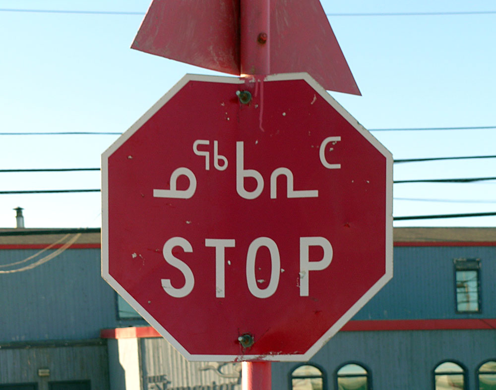
Inuktitut syllabics (, or , ) is an abugida-type writing system used in Canada by the Inuktitut-speaking Inuit of the Provinces and territories of Canada, territory of Nunavut and the Nunavik region of Quebec. In 1976, the Language Commission of the Inuit Cultural Institute made it the co-official script for the Inuit languages, along with the Latin script. The name derives from the root , meaning "mouth". The alternative, Latin-based writing system is named Inuit languages#Writing, (), and it derives from , a word describing the markings or the grain in rocks. meaning "new writing system" is to be seen in contrast to (), the "old syllabics" used before the reforms of 1976. Inuktitut is one variation on Canadian Aboriginal syllabics, and can be digitally encoded using the Unicode standard. The Unicode block for Inuktitut characters is called Unified Canadian Aboriginal Syllabics (Unicode block), Unified Canadian Aboriginal Syllabics. History The first efforts to write In ... [...More Info...] [...Related Items...] OR: [Wikipedia] [Google] [Baidu] |
Baffin Island
Baffin Island (formerly Baffin Land), in the Canadian territory of Nunavut, is the largest island in Canada, the second-largest island in the Americas (behind Greenland), and the fifth-largest island in the world. Its area is (slightly smaller than Thailand) with a population density of 0.03/km2; the population was 13,039 according to the 2021 Canadian census; and it is located at . It also contains the city of Iqaluit (with a population of around 7,000), which is the capital of Nunavut. Name The Inuktitut name for the island is , which means "very big island" ( "island" + "very big") and in Inuktitut syllabics is written as . This name is used for the administrative region the island is part of ( Qikiqtaaluk Region), as well as in multiple places in Nunavut and the Northwest Territories, such as some smaller islands: Qikiqtaaluk in Baffin Bay and Qikiqtaaluk in Foxe Basin. Norse explorers are believed to have referred to it as ("stone land"). In 1576, English seaman ... [...More Info...] [...Related Items...] OR: [Wikipedia] [Google] [Baidu] |
Auyuittuq National Park
Auyuittuq National Park (, , "the land that never melts") is a national park located on Baffin Island's Cumberland Peninsula, in the Qikiqtaaluk Region of Nunavut, the largest political subdivision of Canada. The park was initially known as ''Baffin Island National Park'' when it was established in 1972, but the name was changed in 1976 to its current name to better reflect the region and its history. It features many terrains of Arctic wilderness, such as fjords, glaciers, and ice fields. Although Auyuittuq was established in 1972 as a national park reserve, it was upgraded to a full national park in 2000. Location and access Auyuittuq National Park is located on the Cumberland Peninsula of Baffin Island in Nunavut. The park is located within the Arctic Circle. The park covers The Municipality of Pangnirtung website states that the park measures . and is located partially within the Penny Highlands and contains the Penny Ice Cap. The Penny Ice Cap, made of ice sitting on Pr ... [...More Info...] [...Related Items...] OR: [Wikipedia] [Google] [Baidu] |
Distant Early Warning Line
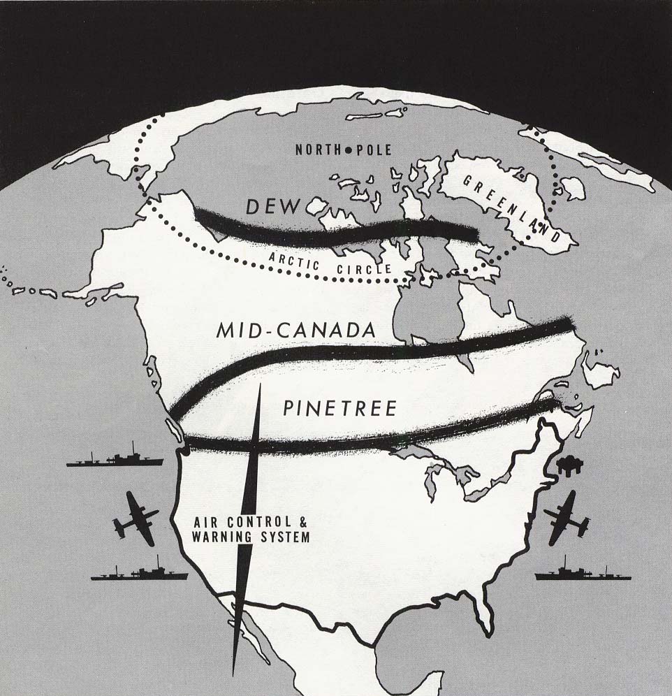
The Distant Early Warning Line, also known as the DEW Line or Early Warning Line, was a system of radar stations in the northern Arctic region of Canada, with additional stations along the north coast and Aleutian Islands of Alaska (see List of White Alice Communications System sites#Project Stretchout sites, Project Stretchout and List of White Alice Communications System sites#Project Bluegrass sites, Project Bluegrass), in addition to the Faroe Islands, Greenland, and Iceland. It was set up to detect incoming bombers of the Soviet Union during the Cold War, and provide early warning of any sea-and-land invasion. The DEW Line was the northernmost and most capable of three radar lines in Canada and Alaska. The first of these was the joint Canadian-United States Pinetree Line, which ran from Newfoundland (island), Newfoundland to Vancouver Island just north of the Canada–United States border, but even while it was being built there were concerns that it would not provide enou ... [...More Info...] [...Related Items...] OR: [Wikipedia] [Google] [Baidu] |
North Warning System
The North Warning System (NWS, ) is a joint United States and Canadian early-warning radar system for the atmospheric air defense of North America. It provides surveillance of airspace from potential incursions or attacks from across North America's polar region. It replaced the Distant Early Warning Line system in the late 1980s. Overview The NWS consists of both long range AN/FPS-117 and short range AN/FPS-124 surveillance radars, operated and maintained by North American Aerospace Defense Command (NORAD). There are 13 long range sites and 36 short range sites. In Canada, the station sites are owned or leased by the Government of Canada, which also owns most of the infrastructure. The radars and tactical radios are owned by the United States Air Force. The Alaska Regional Operations Control Center (ROCC) at Elmendorf AFB, Alaska controls the stations in Alaska; the Canada East and Canada West Regional Operations Control Centres (ROCCs) at CFB North Bay, Ontario control t ... [...More Info...] [...Related Items...] OR: [Wikipedia] [Google] [Baidu] |


