|
Tymphe
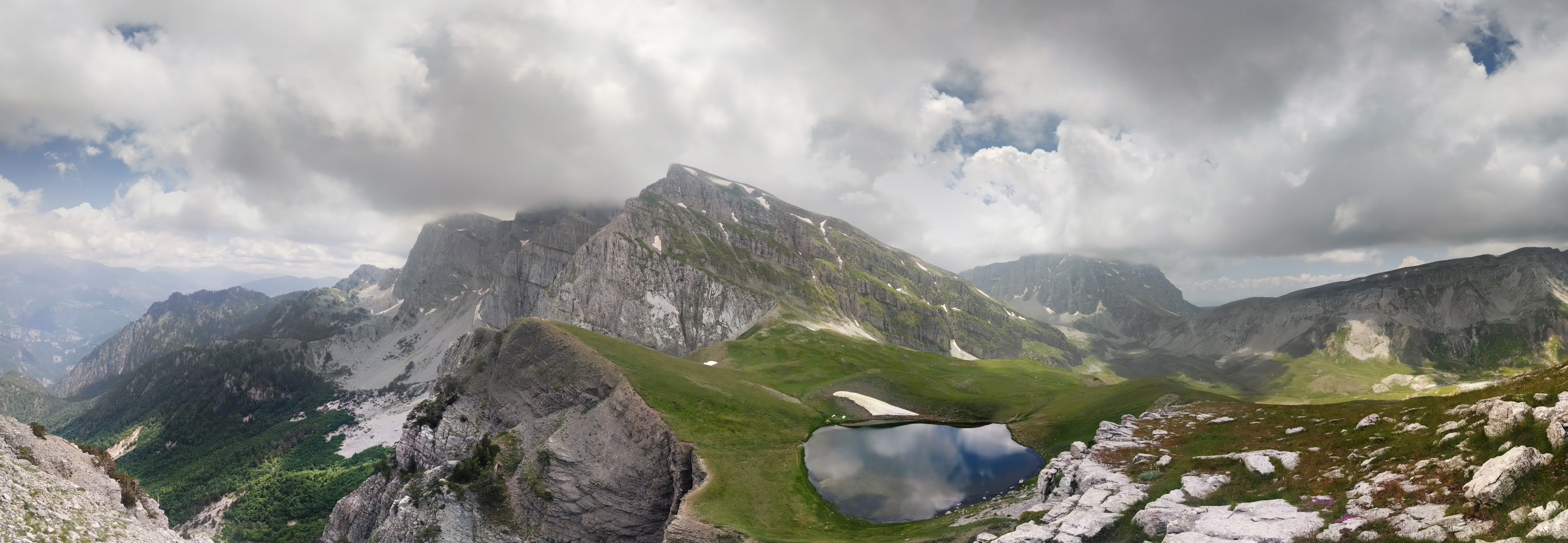
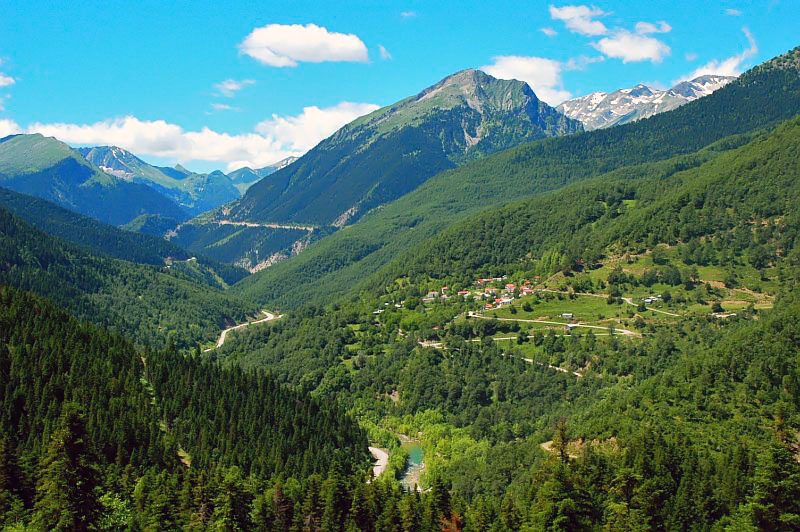
Tymphe (in Latin and English usage) or Tymfi (in the Greek government's preferred transliteration), Timfi, also Tymphi (, ) is a mountain in the northern Pindus mountain range, in northwestern Greece. It is part of the regional units of Greece, regional unit of Ioannina (regional unit), Ioannina and lies in the region of Zagori, just a few metres south of the 40° Parallel (latitude), parallel. Tymphe forms a massif with its highest peak, Gamila, at . The massif of Tymphe includes in its southern part the Vikos Gorge, while they both form part of the Vikos–Aoös National Park which accepts over 100,000 visitors per year. The former municipality of Tymfi (municipal unit), Tymfi owed its name to the mountain. Etymology The exact meaning of the name is not known but has been in use since ancient times. The name "Tymphe" or "Stymphe" is mentioned by ancient geographer Strabo, Book 7, Ch. 7, and is associated with the ancient land of Tymphaea and the Tymphaeans, one of the tribes o ... [...More Info...] [...Related Items...] OR: [Wikipedia] [Google] [Baidu] |
Vikos–Aoös National Park
The Vikos–Aoös National Park ( ''Ethnikós Drymós Víkou–Aóou'') is a national park in the region of Epirus (region), Epirus in northwestern Greece. The park, founded in 1973, is one of ten National parks of Greece, national parks in mainland Greece and is located north of the city of Ioannina, Greece, Ioannina in the northern part of the Pindus mountain range. It is named after the two major gorges of the area and encompasses of mountainous terrain, with numerous rivers, lakes, caves, deep canyons, dense coniferous and deciduous forest. The park is part of the Natura 2000 ecological network and one of UNESCO Geoparks and spans an elevation range from . Over 100,000 people visit the park each year and take part in activities including rafting, canoe-kayaking, hiking and mountain biking. The core of the park, an area of , comprises the spectacular Vikos Gorge, carved by the Voidomatis river. The gorge's main part is long, which attains a depth of , and has a width rangi ... [...More Info...] [...Related Items...] OR: [Wikipedia] [Google] [Baidu] |
Tymphaea
Tymphaea or Tymphaia () was an ancient Greek territory, specifically located in the region of Epirus, inhabited by the Tymphaioi, a northwestern Greek tribe that belonged to the Molossian tribal state or ''koinon''. The tribal territory was annexed by and became a province of the Kingdom of Macedon, specifically Upper Macedonia, in the 4th century BC. History Due to the fact that Greek toponyms that preserve archaic features are very densely found in the wider area, it appears that speakers of the proto-Greek language inhabited a region which included Tymphaea before the late Bronze Age migrations (late 3rd-early 2nd millennium B.C) during several centuries or even millennia before. Tymphaea and its Greek inhabitants, the Tymphaioi, were named after Mount Tymphe. In circa 350 BC, Tymphaea was conquered by Phillip II (r. 359–336 BC) and incorporated into the Kingdom of Macedon as part of Upper Macedonia. The most famous native of Tymphaea was Polyperchon, regent of Alexander II ... [...More Info...] [...Related Items...] OR: [Wikipedia] [Google] [Baidu] |
Zagori
Zagori (; ), is a region, a municipality, and a designated UNESCO World Heritage Site, in the Pindus mountains in Epirus, in northwestern Greece. The seat of the municipality is the village Asprangeloi. It has an area of some and contains 46 villages known as Zagori villages (or Zagorochoria or Zagorohoria), and is in the shape of an upturned equilateral triangle. Ioannina, the provincial capital, is at the southern point of the triangle, while the south-western side is formed by Mount Mitsikeli (1,810m). The Aoos river running north of Mt Tymphe forms the northern boundary, while the south-eastern side runs along the Varda river to Mount Mavrovouni (2,100m) near Metsovo. The municipality has an area of 989.796 km2. The population of the area is about 3,400, which gives a population density of 3.4 inhabitants per square kilometer, very sparse when compared to an average of 73.8 for Greece as a whole. Geography Zagori is an area of great natural beauty, with striking ... [...More Info...] [...Related Items...] OR: [Wikipedia] [Google] [Baidu] |
Vikos Gorge
The Vikos Gorge or Vikos Canyon () is a gorge in the Pindus Mountains of northwestern Greece. It lies on the southern slopes of Mount Tymphe with a length of about 32 km, depth ranging from 120 to 1350 m, and a width ranging from 2500 m to only a few meters at its narrowest part. Vikos is listed as the world's "deepest relative to its width" gorge by the Guinness Book of Records among others. Etymology There are a number of views regarding the etymology of the name: *According to Ioannis Lambridis it derives from Slavic and means 'chasm' or 'gorge'. *According to Evangelos Bogas it derives from the Greek βίκος ' stamnos with ears', which denotes the shape of the gorge and the echoes caused by sounds within it. The word was recorded in the lexicon of Hesychius of Alexandria. *According to Konstantinos Amantos it derives from the Greek phytonym βικίον. *According to Konstantinos Oikonomou it derives from an Albanian word for bridge or wooden pass, ''vig-u'' ... [...More Info...] [...Related Items...] OR: [Wikipedia] [Google] [Baidu] |
Pindus
The Pindus (also Pindos or Pindhos; ; ; ) is a mountain range located in Northern Greece and Southern Albania. It is roughly long, with a maximum elevation of (Smolikas, Mount Smolikas). Because it runs along the border of Thessaly and Epirus, the Pindus range is known colloquially as the ''spine of Greece''. The mountain range stretches from near the Greek-Albanian border in southern Albania, entering the Epirus (region), Epirus and Macedonia (Greece), Macedonia regions in northern Greece down to the north of the Peloponnese. Geologically, it is an extension of the Dinaric Alps, which dominate the western region of the Balkans, Balkan Peninsula. History of the name Historically, the name Pindos refers to the mountainous territory that separates the greater Epirus region from the regions of Macedonia and Thessaly. According to John Tzetzes (a 12th-century Byzantine writer), the Pindos range was then called Metzovon. When translated (between 1682/83 and 1689) to a more co ... [...More Info...] [...Related Items...] OR: [Wikipedia] [Google] [Baidu] |
Camel
A camel (from and () from Ancient Semitic: ''gāmāl'') is an even-toed ungulate in the genus ''Camelus'' that bears distinctive fatty deposits known as "humps" on its back. Camels have long been domesticated and, as livestock, they provide food ( camel milk and meat) and textiles (fiber and felt from camel hair). Camels are working animals especially suited to their desert habitat and are a vital means of transport for passengers and cargo. There are three surviving species of camel. The one-humped dromedary makes up 94% of the world's camel population, and the two-humped Bactrian camel makes up 6%. The wild Bactrian camel is a distinct species that is not ancestral to the domestic Bactrian camel, and is now critically endangered, with fewer than 1,000 individuals. The word ''camel'' is also used informally in a wider sense, where the more correct term is "camelid", to include all seven species of the family Camelidae: the true camels (the above three species), along ... [...More Info...] [...Related Items...] OR: [Wikipedia] [Google] [Baidu] |
Eaves
The eaves are the edges of the roof which overhang the face of a wall and, normally, project beyond the side of a building. The eaves form an overhang to throw water clear of the walls and may be highly decorated as part of an architectural style, such as the Chinese dougong bracket systems. Etymology and usage According to the ''Oxford English Dictionary'', ''eaves'' is derived from the Old English (singular), meaning "edge", and consequently forms both the singular and plural of the word. This Old English word is itself of Germanic origin, related to the German dialect ''Obsen'', and also probably to ''over''. The Merriam-Webster dictionary lists the word as ''eave'' but notes that it is "usually used in plural". Function The primary function of the eaves is to keep rain water off the walls and to prevent the ingress of water at the junction where the roof meets the wall. The eaves may also protect a pathway around the building from the rain, prevent erosion of the footi ... [...More Info...] [...Related Items...] OR: [Wikipedia] [Google] [Baidu] |
Sorrel
Sorrel (''Rumex acetosa''), also called common sorrel or garden sorrel, is a perennial herbaceous plant in the family Polygonaceae. Other names for sorrel include spinach dock and narrow-leaved dock ("dock" being a common name for the genus ''Rumex''). Sorrel is native to Eurasia and a common plant in grassland habitats. It is often cultivated as a leaf vegetable or herb. Description Sorrel is a slender herbaceous perennial plant about high, with roots that run deep into the ground, as well as juicy stems and arrow-shaped (sagittate) leaves which grow from a Rosette (botany), rosette. The lower leaves are in length with long Petiole (botany), petioles and a membranous ocrea formed of fused, sheathing stipules. The upper leaves are Sessility (botany), sessile, (growing directly from the stem without a petiole) and frequently become crimson. It has whorled spikes of reddish-green flowers, which bloom in early summer, becoming purplish. The species is dioecious, with stamens and ... [...More Info...] [...Related Items...] OR: [Wikipedia] [Google] [Baidu] |
Smolikas
Mount Smolikas (; ) is a mountain in the Ioannina regional unit, northwestern Greece. At a height of 2,637 metres above sea level, it is the highest of the Pindus Mountains, and the second highest mountain in Greece after Mount Olympus. The mountain consists of ophiolite rocks. During several periods in the Pleistocene the northern and eastern cirques and valleys were glaciated. The last glaciers of this area retreated around 11,500 years ago. It is drained by the river Vjosa to the south, and the river Vourkopotamo (a tributary of the Sarantaporos) to the north. There is a small alpine lake called " Drakolimni Smolika" near the summit, at about 2,200 metres elevation. Nearby mountain ranges are Tymfi to the south, Gramos to the northwest, Vasilitsa to the southeast and Voio to the northeast. The higher elevations, above 2,000 metres, consist of grasslands and rocks, and there are deciduous and conifer forests at lower elevations. The mountain lies completely within the m ... [...More Info...] [...Related Items...] OR: [Wikipedia] [Google] [Baidu] |
Aromanian Language
The Aromanian language (, , , , , or , , ), also known as Vlach or Macedo-Romanian, is an Eastern Romance languages, Eastern Romance language, similar to Megleno-Romanian language, Megleno-Romanian, Istro-Romanian language, Istro-Romanian and Romanian language, Romanian, spoken in Southeast Europe, Southeastern Europe. Its speakers are called Aromanians or Vlachs (a broader term and an Endonym and exonym, exonym in widespread use to define Romance communities in the Balkans). Aromanian shares many features with modern Romanian language, Romanian, including similar morphology and syntax, as well as a large common vocabulary inherited from Latin. They are considered to have developed from Common Romanian, a common stage of all the Eastern Romance varieties. An important source of dissimilarity between Romanian and Aromanian is the Stratum (linguistics)#Adstratum, adstratum languages (external influences); whereas Romanian Slavic influence on Romanian, has been influenced to a g ... [...More Info...] [...Related Items...] OR: [Wikipedia] [Google] [Baidu] |
Trapezitsa
Trapezitsa () is a village and a community of the Voio municipality in Greece. Before the 2011 local government reform, it was part of the municipality of Neapoli, of which it was a municipal district. The 2021 census recorded 76 inhabitants in the community of Trapezitsa. The community of Trapezitsa covers an area of 10.275 km2. Administrative division The community of Trapezitsa consists of two separate settlements: *Panareti (population 14 in 2021) *Trapezitsa (population 62) See also *List of settlements in the Kozani regional unit This is a list of settlements in the Kozani regional unit, Greece. * Achladia * Agia Kyriaki * Agia Paraskevi * Agia Sotira * Agiasma * Agioi Anargyroi * Agioi Theodoroi * Agios Charalampos * Agios Christoforos * Agios Dimitrios * Agios T ... References Populated places in Kozani (regional unit) Voio (municipality) {{WMacedonia-geo-stub ... [...More Info...] [...Related Items...] OR: [Wikipedia] [Google] [Baidu] |
Lygkos
Lyngos (), also transliterated as ''Lygos'', is a remote mountain range in the eastern Ioannina and the western Grevena regional unit in northwestern Greece. It is a part of the Pindus mountain range. Its highest point is the Avgo, at 2,177 m elevation. The Lyngos mountains lie in a horseshoe shape around the Valia Kalda (Βάλια Κάλντα) valley, which exits towards the Aoos valley to the west. The Valia Kalda is part of the Pindus-Valia Kalda National Park, founded in 1966. It is one of the coldest and wettest regions of Greece. The mountains are densely forested, with alpine meadows in the highest ... [...More Info...] [...Related Items...] OR: [Wikipedia] [Google] [Baidu] |


