|
Staten Island Serpentinite
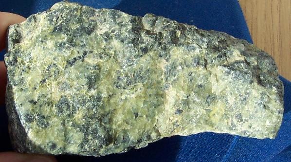
The Staten Island Serpentinite locality is a southward extension of the New England Uplands, adjacent to the Manhattan Prong. It includes Todt Hill on Staten Island, which is the highest point along the Atlantic Seaboard south of Maine, at above sea level. "Todt" is a Dutch word meaning "dead." This hill perhaps received its name from the Dutch settlers because the hilltops overlooking The Narrows consisted of scattered treeless rocky exposures. The chemical character of the bedrock was, in part, the reason for this. Much of Staten Island is covered by the Harbor Hill moraine, the terminal moraine of the last Wisconsin Stage glacier. However, ledges of bedrock consisting of serpentinite are exposed throughout the upland areas on Staten Island. Grymes Hill, the second highest point on Staten Island and just a few miles from Todt Hill has similar bedrock characteristics. Serpentine, the dominant mineral in serpentinite, is rich in magnesium, an element that most plants cannot tolera ... [...More Info...] [...Related Items...] OR: [Wikipedia] [Google] [Baidu] |
New England Uplands
The topography of the New England Uplands section is that of a maturely-dissected plateau with narrow valleys, and the entire area is greatly modified by glaciation. It is the most widespread of the geomorphic sections in the New England Province, extending from Canada through New England down to the Seaboard section and extending southwestward through New York and New Jersey as two narrow upland projections, the Reading Prong and the Manhattan Prong. Numerous hills and mountains rise above the general level of the upland; except in the presence of mountains, the horizon of the regional landscape is fairly level. Glaciation has resulted in the erosion and rounding off of the bedrock topography and numerous rock basin lakes. Glacial drift is thin, patchy, and stony, and ice-contact features such as kames, kame terraces, and eskers are abundant. The surface of the New England Uplands slopes southeast from maximum inland altitudes around , excluding the other mountainous sections of the ... [...More Info...] [...Related Items...] OR: [Wikipedia] [Google] [Baidu] |
Serpentine Subgroup
Serpentine subgroup (part of the kaolinite-serpentine group in the category of phyllosilicates) are greenish, brownish, or spotted minerals commonly found in serpentinite. They are used as a source of magnesium and asbestos, and as decorative stone. The name comes from the greenish colour and smooth or scaly appearance from the Latin , meaning "serpent rock". Serpentine subgroup is a set of common rock-forming hydrous magnesium iron phyllosilicate () minerals, resulting from the metamorphism of the minerals that are contained in mafic to ultramafic rocks. They may contain minor amounts of other elements including chromium, manganese, cobalt or nickel. In mineralogy and gemology, serpentine may refer to any of the 20 varieties belonging to the serpentine subgroup. Owing to admixture, these varieties are not always easy to individualize, and distinctions are not usually made. There are three important mineral polymorphs of serpentine: antigorite, lizardite and chrysotile. ... [...More Info...] [...Related Items...] OR: [Wikipedia] [Google] [Baidu] |
Appalachian Mountains
The Appalachian Mountains, often called the Appalachians, (french: Appalaches), are a system of mountains in eastern to northeastern North America. The Appalachians first formed roughly 480 million years ago during the Ordovician Period. They once reached elevations similar to those of the Alps and the Rocky Mountains before experiencing natural erosion. The Appalachian chain is a barrier to east–west travel, as it forms a series of alternating ridgelines and valleys oriented in opposition to most highways and railroads running east–west. Definitions vary on the precise boundaries of the Appalachians. The United States Geological Survey (USGS) defines the ''Appalachian Highlands'' physiographic division as consisting of 13 provinces: the Atlantic Coast Uplands, Eastern Newfoundland Atlantic, Maritime Acadian Highlands, Maritime Plain, Notre Dame and Mégantic Mountains, Western Newfoundland Mountains, Piedmont, Blue Ridge, Valley and Ridge, St. Lawrence Valley, A ... [...More Info...] [...Related Items...] OR: [Wikipedia] [Google] [Baidu] |
Geology Of New York (state)
The geology of the State of New York is made up of ancient Precambrian crystalline basement rock, forming the Adirondack Mountains and the bedrock of much of the state. These rocks experienced numerous deformations during mountain building events and much of the region was flooded by shallow seas depositing thick sequences of sedimentary rock during the Paleozoic. Fewer rocks have deposited since the Mesozoic as several kilometers of rock have eroded into the continental shelf and Atlantic coastal plain, although volcanic and sedimentary rocks in the Newark Basin are a prominent fossil-bearing feature near New York City from the Mesozoic rifting of the supercontinent Pangea. Stratigraphy, Tectonics & Geologic History The igneous and metamorphic crystalline basement rock of New York formed in the Precambrian and are coterminous with the Canadian Shield. The Adirondack Mountains, Thousand Islands, Hudson Highlands, and Fordham gneiss, along with outcrops in the Berkshires just o ... [...More Info...] [...Related Items...] OR: [Wikipedia] [Google] [Baidu] |
Cameron's Line
Cameron's Line is an Ordovician suture fault in the northeast United States which formed as part of the continental collision known as the Taconic orogeny around 450 mya. Named after Eugene N. Cameron, who first described it in the 1950s, it ties together the North American continental craton, the prehistoric Taconic Island volcanic arc, and the bottom of the ancient Iapetus Ocean. Location Cameron's Line winds southward out of New England through Western Connecticut. It has been identified in western Connecticut near Ridgefield before it heads into the Bronx, along the East River in Manhattan, through New York Bay, Staten Island and into New Jersey. Geology The basement rocks of the Manhattan Formation located on the western side of Cameron's line are metamorphosed sedimentary rocks and can be thought of as the remnants of the edge of the North American continent from 1 billion years ago. They were formed in roughly this location (autochthonous) and have been tectonic ... [...More Info...] [...Related Items...] OR: [Wikipedia] [Google] [Baidu] |
Taconic Orogeny
The Taconic orogeny was a mountain building period that ended 440 million years ago and affected most of modern-day New England. A great mountain chain formed from eastern Canada down through what is now the Piedmont of the East coast of the United States. As the mountain chain eroded in the Silurian and Devonian periods, sediments from the mountain chain spread throughout the present-day Appalachians and midcontinental North America. New England and Canada Beginning in Cambrian time, about 550 million years ago, the Iapetus Ocean began to close. The weight of accumulating sediments, in addition to compressional forces in the crust, forced the eastern edge of the North American continent to fold gradually downward. In this manner, shallow-water carbonate deposition that had persisted on the continental shelf margin through Late Cambrian into Early Ordovician time, gave way to fine-grained clastic deposition and deeper water conditions during the Middle Ordovician. In this period ... [...More Info...] [...Related Items...] OR: [Wikipedia] [Google] [Baidu] |
Iapetus Ocean
The Iapetus Ocean (; ) was an ocean that existed in the late Neoproterozoic and early Paleozoic eras of the geologic timescale (between 600 and 400 million years ago). The Iapetus Ocean was situated in the southern hemisphere, between the paleocontinents of Laurentia, Baltica and Avalonia. The ocean disappeared with the Acadian, Caledonian and Taconic orogenies, when these three continents joined to form one big landmass called Euramerica. The "southern" Iapetus Ocean has been proposed to have closed with the Famatinian and Taconic orogenies, meaning a collision between Western Gondwana and Laurentia. Because the Iapetus Ocean was positioned between continental masses that would at a much later time roughly form the opposite shores of the Atlantic Ocean, it can be seen as a sort of precursor of the Atlantic, and the process by which it opened shares many similarities with that of the Atlantic's initial opening in the Jurassic. The Iapetus Ocean was therefore named for the ... [...More Info...] [...Related Items...] OR: [Wikipedia] [Google] [Baidu] |
Chrysotile
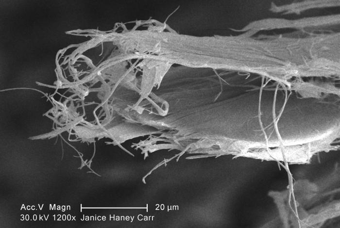
Chrysotile or white asbestos is the most commonly encountered form of asbestos, accounting for approximately 95% of the asbestos in the United StatesOccupational Safety and Health Administration, U.S. Department of Labor (2007)29 C.F.R. 1910.1001 Appendix J. and a similar proportion in other countries.Institut national de recherche sur la sécurité (1997).Amiante." ''Fiches toxicologiques.'' n° 167. (in French) It is a soft, fibrous silicate mineral in the serpentine subgroup of phyllosilicates; as such, it is distinct from other asbestiform minerals in the amphibole group. Its idealized chemical formula is Mg( Si O)( OH). The material has physical properties which make it desirable for inclusion in building materials, but poses serious health risks when dispersed into air and inhaled. Polytypes Three polytypes of chrysotile are known. These are very difficult to distinguish in hand specimens, and polarized light microscopy must normally be used. Some older publi ... [...More Info...] [...Related Items...] OR: [Wikipedia] [Google] [Baidu] |
Serpentine Soil
Serpentine soil is an uncommon soil type produced by weathered ultramafic rock such as peridotite and its metamorphic derivatives such as serpentinite. More precisely, serpentine soil contains minerals of the serpentine subgroup, especially antigorite, lizardite, and chrysotile or white asbestos, all of which are commonly found in ultramafic rocks. The term "serpentine" is commonly used to refer to both the soil type and the mineral group which forms its parent materials. Serpentine soils exhibit distinct chemical and physical properties and are generally regarded as poor soils for agriculture. The soil is often reddish, brown, or gray in color due to its high iron and low organic content. Geologically, areas with serpentine bedrock are characteristically steep, rocky, and vulnerable to erosion, which causes many serpentine soils to be rather shallow. The shallow soils and sparse vegetation lead to elevated soil temperatures and dry conditions. Due to their ultramafic origin, se ... [...More Info...] [...Related Items...] OR: [Wikipedia] [Google] [Baidu] |
Manhattan Prong
The Manhattan Prong of the New England Uplands is a smaller belt of ancient rock in southern New York (including Manhattan, the Bronx, and segments of Brooklyn and Staten Island), parts of Westchester County, and upland portions of southwestern Connecticut. The Manhattan Prong and the Reading Prong are separated by the Newark Basin in the south, but the two features merge at the northern terminus of the Newark Basin in the vicinity of Peekskill, New York. A band of mountains that rise nearly one thousand feet along the northwestern margin of the Newark Basin in New York and New Jersey are called the Ramapo Mountains. Another belt of ancient metamorphic and igneous rock crops out along the southern margin of the Newark Basin south and west of Trenton, New Jersey. In this region the rocks are referred to as part of the Trenton Prong. This region includes Manhattan schist and Tuckahoe marble Tuckahoe marble (also known as Inwood and Westchester marble) is a type of marble found in ... [...More Info...] [...Related Items...] OR: [Wikipedia] [Google] [Baidu] |
Magnesium
Magnesium is a chemical element with the symbol Mg and atomic number 12. It is a shiny gray metal having a low density, low melting point and high chemical reactivity. Like the other alkaline earth metals (group 2 of the periodic table) it occurs naturally only in combination with other elements and it almost always has an oxidation state of +2. It reacts readily with air to form a thin passivation coating of magnesium oxide that inhibits further corrosion of the metal. The free metal burns with a brilliant-white light. The metal is obtained mainly by electrolysis of magnesium salts obtained from brine. It is less dense than aluminium and is used primarily as a component in strong and lightweight alloys that contain aluminium. In the cosmos, magnesium is produced in large, aging stars by the sequential addition of three helium nuclei to a carbon nucleus. When such stars explode as supernovas, much of the magnesium is expelled into the interstellar medium where it m ... [...More Info...] [...Related Items...] OR: [Wikipedia] [Google] [Baidu] |
Grymes Hill
Grymes Hill is a tall hill formed of serpentine rock on Staten Island, New York. It is the second highest natural point on the island and in the five boroughs of New York City. The neighborhood of the same name encompasses an area of and has a population of 8,263 people. The hill also includes parts of the Silver Lake neighborhood. The area includes part of ZIP Codes 10301 and 10304. Etymology The hill is named after Suzette Grymes, wife of prominent New Orleans lawyer and member of the First Families of Virginia, John Randolph Grymes. Her first husband was the first governor of Louisiana, William Charles Cole Claiborne. She settled on Staten Island in 1836. Geography Neighborhoods around Grymes Hill include Ward Hill to the north, Silver Lake to the west, Sunnyside and Emerson Hill to the south, to the southeast is Concord, and Stapleton and Stapleton Heights to the east. The east side of the hill is defined by Van Duzer Street and Richmond Road to the intersection ... [...More Info...] [...Related Items...] OR: [Wikipedia] [Google] [Baidu] |


