|
Oud-Beijerland
Oud-Beijerland () is a town and former municipality in the western Netherlands, in the province of South Holland, now a part of the Hoeksche Waard municipality. With a population of 24,575 in 2020, it is the most populous town of the Hoeksche Waard island. The town is located adjacent to the confluence of the Oude Maas and Spui River. The town of Oud-Beijerland also includes the communities Vuurbaken and Zinkweg. History After the St. Elizabeth's flood (1421), large parts of the islands Putten and Grote Waard were lost and became clay banks and salt marshes which would be inundated at high tide and be unsuitable for habitation. In subsequent centuries, portions of land would be reclaimed. Oud-Beijerland was formed in 1559 as "Beijerland" by Lamoral, Count of Egmont. He was granted the rights to this area in 1557 and had the land reclaimed. This new polder was named ''Beijerland, Moerkerken, Cromstrijen en de Greup''. Circa 1624 the smaller polders Bosschenpolder and Nieuwlan ... [...More Info...] [...Related Items...] OR: [Wikipedia] [Google] [Baidu] |
Hoeksche Waard (municipality)
Hoeksche Waard () is a municipality in the western Netherlands, in the province of South Holland, consisting of the eponymous Hoeksche Waard and Tiengemeten islands. The municipality was formed on 1 January 2019 by the merger of the municipalities Binnenmaas, Cromstrijen, Korendijk, Oud-Beijerland, and Strijen. Gallery File:'s-Gravendeel, de Kerk op de Heul GM1963-WN13 IMG 0979 2021-09-06 17.30.jpg, 's-Gravendeel, church: the Kerk op de Heul File:'s-Gravendeel, korenmolen het Vliegend Hert RM17406 foto3 2014-04-14 17.10.jpg, 's-Gravendeel, windmill: korenmolen het Vliegend Hert File:Westmaas, de Nederlands Hervormde kerk RM38856 IMG 0929 2021-09-06 13.38.jpg, Westmaas, reformed church File:Klaaswaal, de Nederlands Hervormde kerk RM23662 IMG 0941 2021-09-06 14.04.jpg, Klaaswaal, reformed church File:Strijen, de Grote- of Sint Lambertuskerk RM34945 IMG 0960 2021-09-06 16.04.jpg, Strijen, church: the Grote- or Sint Lambertuskerk File:Maasdam, de Kerk GM1963-WN24 IMG 0978 2 ... [...More Info...] [...Related Items...] OR: [Wikipedia] [Google] [Baidu] |
Binnenmaas
Binnenmaas () was a municipality in the western Netherlands, in the province of South Holland. The municipality had a population of in , and covers an area of of which is water. It is named after the lake of the same name. The municipality was formed on 1 January 1984 by the merger of the municipalities Puttershoek, Maasdam, Mijnsheerenland, Westmaas, and Heinenoord. On 1 January 2007 the municipality 's-Gravendeel was added to Binnenmaas. On 1 January 2019 it was merged with Cromstrijen, Korendijk, Oud-Beijerland, and Strijen to form the municipality of Hoeksche Waard. 11 July 2018, accessed at overheid.nl The municipality of Binnenmaas consists of the following communit ... [...More Info...] [...Related Items...] OR: [Wikipedia] [Google] [Baidu] |
Nieuw-Beijerland
Nieuw-Beijerland is a village in the Dutch province of South Holland. It is a part of the municipality of Hoeksche Waard, and lies about 3 km south of Spijkenisse. History The village was first mentioned in 1773 as Nieuw Beierland, and is named after the polder which was created in 1582. Nieuw (new) has been added to distinguish from Oud-Beijerland. The centre of the village has a grid structure. The Dutch Reformed church is an aisleless church with needle tower built in 1826. The grist mill De Swaen was originally built in 1703, but rebuilt in 1932 after a fire. The wind mill can turn, but the inner workings have been removed. Nieuw-Beijerland was home to 1,012 people in 1840. It was a separate municipality until 1984, when it became part of Korendijk. Korendijk was merged into the new municipality Hoeksche Waard The Hoekse Waard (; pre-1947 spelling: Hoeksche Waard) is an island between the Oude Maas, Dordtsche Kil, Hollands Diep, Haringvliet and Spui rivers in t ... [...More Info...] [...Related Items...] OR: [Wikipedia] [Google] [Baidu] |
Vuurbaken
Vuurbaken is a hamlet in the Dutch province of South Holland and is part of the municipality of Hoeksche Waard. It lies to the south of Oud-Beijerland and about 1 km from Zinkweg. Vuurbaken is not a statistical entity, and considered part of Oud-Beijerland and Nieuw-Beijerland Nieuw-Beijerland is a village in the Dutch province of South Holland. It is a part of the municipality of Hoeksche Waard, and lies about 3 km south of Spijkenisse. History The village was first mentioned in 1773 as Nieuw Beierland, and is n .... It has no place name signs, and consists of about 30 houses. References Populated places in South Holland Hoeksche Waard {{SouthHolland-geo-stub ... [...More Info...] [...Related Items...] OR: [Wikipedia] [Google] [Baidu] |
Spui River
The Spui is a small tidal river in South Holland in the Netherlands, connecting the river Oude Maas and the Haringvliet estuary, separating the islands of Voorne-Putten and Hoeksche Waard. Historically, it forked off the Oude Maas at the town of Oud-Beijerland to end in the Haringvliet, but as a (planned) result from the Delta Works, its flow has been reversed. The Spui emerged as a result of a levee breach during the , a storm surge that permanently altered the surrounding landscape. There are no bridges or tunnels crossing the Spui, but there is a car ferry from Hekelingen (municipality Nissewaard) to Nieuw-Beijerland (municipality Hoeksche Waard), and a pedestrian and bicycle ferry between Oud-Beijerland and Rhoon (in Albrandswaard Albrandswaard () is a municipality in the western Netherlands, in the province of South Holland. The municipality had a population of as of , and covers an area of of which is water. The municipality of Albrandswaard consists of the villages ... [...More Info...] [...Related Items...] OR: [Wikipedia] [Google] [Baidu] |
Cromstrijen
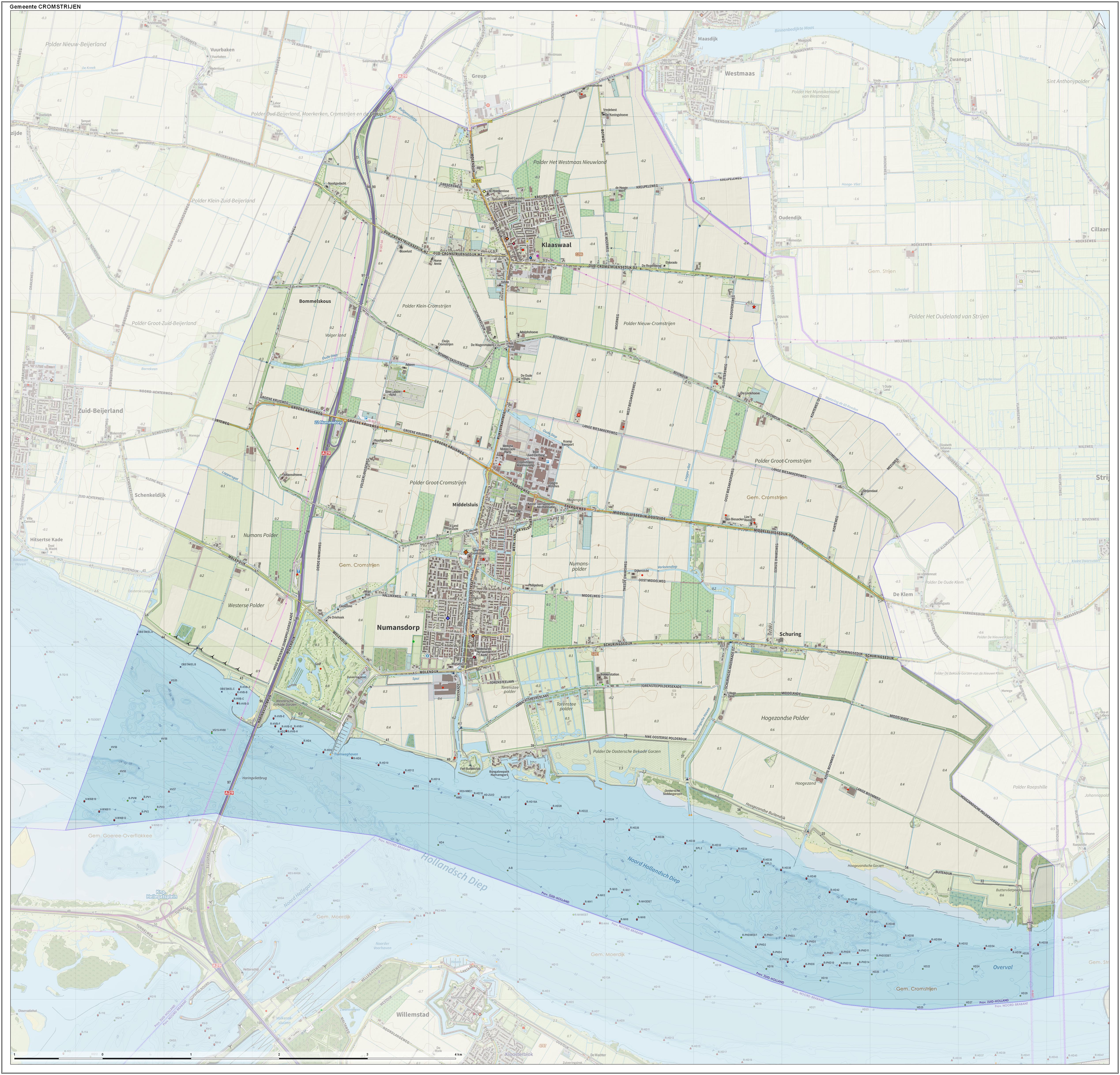
Cromstrijen (; ''Cromstrien'' in local dialect) was a municipality on the Hoeksche Waard Island in the western Netherlands , Terminology of the Low Countries, informally Holland, is a country in Northwestern Europe, with Caribbean Netherlands, overseas territories in the Caribbean. It is the largest of the four constituent countries of the Kingdom of the Nether ..., in the province of South Holland. The municipality covers an area of of which is water. It was formed on 1 January 1984, when the municipalities on the Hoeksche Waard were merged into larger municipalities. On 1 January 2019 it was merged with the municipalities of Binnenmaas, Korendijk, Oud-Beijerland, and Strijen to form the municipality of Hoeksche Waard. The municipality of Cromstrijen consists of the communities Klaaswaal and Numansdorp (townhall). Its population was in . Topography ''Dutch topographic map of the municipality of Cromstrijen, June 2015'' See also References External ... [...More Info...] [...Related Items...] OR: [Wikipedia] [Google] [Baidu] |
Korendijk
Korendijk () was a municipality in the western Netherlands, in the province of South Holland. The municipality covered an area of of which was water. With the municipal reorganization of the Hoeksche Waard on 1 January 1984, the municipality of Korendijk was formed out of the former municipalities of Goudswaard, Nieuw-Beijerland, Piershil (location of town hall), Zuid-Beijerland, and the island Tiengemeten. In addition to these villages, it also had the population centres Nieuwendijk and Zuidzijde. On 1 January 2019, it merged into the municipality of Hoeksche Waard. The municipality of Korendijk was bordered on the southside by the Haringvliet The Haringvliet is a large inlet of the North Sea, in the province of South Holland in the Netherlands. It is an important estuary of the Rhine-Meuse delta. Near Numansdorp, the Hollands Diep splits into the Haringvliet and the Volkerak est ... estuary, on the westside by the Spui River, and by the municipalities Oud-Be ... [...More Info...] [...Related Items...] OR: [Wikipedia] [Google] [Baidu] |
Spui (river)
The Spui is a small tidal river in South Holland in the Netherlands, connecting the river Oude Maas and the Haringvliet estuary, separating the islands of Voorne-Putten and Hoeksche Waard. Historically, it forked off the Oude Maas at the town of Oud-Beijerland to end in the Haringvliet, but as a (planned) result from the Delta Works, its flow has been reversed. The Spui emerged as a result of a levee breach during the , a storm surge that permanently altered the surrounding landscape. There are no bridges or tunnels crossing the Spui, but there is a car ferry A ferry is a boat or ship that transports passengers, and occasionally vehicles and cargo, across a body of water. A small passenger ferry with multiple stops, like those in Venice, Italy, is sometimes referred to as a water taxi or water bus ... from Hekelingen (municipality Nissewaard) to Nieuw-Beijerland (municipality Hoeksche Waard), and a pedestrian and bicycle ferry between Oud-Beijerland and Rhoon ... [...More Info...] [...Related Items...] OR: [Wikipedia] [Google] [Baidu] |
Spijkenisse
Spijkenisse () is a large town in the Provinces of the Netherlands, province of South Holland, Netherlands. Following an administrative reform in 2015, it is part of the List of municipalities of the Netherlands, municipality of Nissewaard, and has a population of 72,500. It covers an area of of which is water. It is part of the Rijnmond, Greater Rotterdam area. History Archaeological evidence suggests that the area around Spijkenisse has been inhabited for several thousand years. The area's prehistoric inhabitants depended on fishing in the Maas and hunting in the surrounding swamps for sustenance. The oldest known reference to the name ''Spickenisse'' is in a source from 1231. Spijkenisse is a portmanteau of the words ' (Spit (landform), spit) and ''nesse'' (nose) meaning "pointy nose." The name is a reference to the settlement's location on a spit of land protruding into the river. Spijkenisse formed as a farming and fishing village on a creek along the Oude Maas. It origin ... [...More Info...] [...Related Items...] OR: [Wikipedia] [Google] [Baidu] |
Telephone Numbers In The Netherlands
Telephone numbers in the Netherlands are administered by the Ministry of Economic Affairs, Agriculture and Innovation of the Netherlands. The telephone numbering plan may be grouped into three general categories: geographical numbers, non-geographical numbers, and numbers for public services. Geographical telephone numbers have nine digits and consist of an area code of two or three digits and a subscriber number of seven or six digits, respectively. When dialled within the country, the number must be prefixed with the trunk access code 0, identifying a destination telephone line in the Dutch telephone network. Non-geographical numbers have no fixed length, but also require the dialling of the trunk access code (0). They are used for mobile telephone networks and other designated service types, such as toll-free dialling, Internet access, voice over IP, restricted audiences, and information resources. In addition, special service numbers exist for emergency response, directory ... [...More Info...] [...Related Items...] OR: [Wikipedia] [Google] [Baidu] |
Hoeksche Waard
The Hoekse Waard (; pre-1947 spelling: Hoeksche Waard) is an island between the Oude Maas, Dordtsche Kil, Hollands Diep, Haringvliet and Spui rivers in the province of South Holland in the Netherlands. The island, part of the namesake municipality of Hoeksche Waard, is a mostly agricultural region, south of the outskirts of Rotterdam. The Hoeksche Waard consists of reclaimed land (polders): after the Saint Elisabeth flood of 1421 most of the area was flooded. The land has been reclaimed gradually in the following centuries. Former municipalities The Hoeksche Waard formerly consisted of the following municipalities until these were merged on 1 January 2019: * Binnenmaas (villages Blaaksedijk, Heinenoord, Goidschalxoord, Maasdam, Mijnsheerenland, Puttershoek, Westmaas and 's-Gravendeel) * Cromstrijen (villages Klaaswaal and Numansdorp) * Korendijk (villages Goudswaard, Nieuw-Beijerland, Piershil and Zuid-Beijerland, and the island of Tiengemeten) * Oud-Beije ... [...More Info...] [...Related Items...] OR: [Wikipedia] [Google] [Baidu] |


