|
Binnenmaas
Binnenmaas () was a municipality in the western Netherlands, in the province of South Holland. The municipality had a population of in , and covers an area of of which is water. It is named after the lake of the same name. The municipality was formed on 1 January 1984 by the merger of the municipalities Puttershoek, Maasdam, Mijnsheerenland, Westmaas, and Heinenoord. On 1 January 2007 the municipality 's-Gravendeel was added to Binnenmaas. On 1 January 2019 it was merged with Cromstrijen, Korendijk, Oud-Beijerland, and Strijen to form the municipality of Hoeksche Waard. 11 July 2018, accessed at overheid.nl The municipality of Binnenmaas consists of the following communit ... [...More Info...] [...Related Items...] OR: [Wikipedia] [Google] [Baidu] |
Mijnsheerenland
Mijnsheerenland is a village and a former municipality on the Hoeksche Waard island in the Dutch province of South Holland with 4,435 inhabitants (as of 1 January 2006). It is located on the shores of the ''Binnenbedijkte Maas'' (Lake Binnenmaas), about 14 km south of the city of Rotterdam, in the municipality of Hoeksche Waard. It was the only village in the former municipality Binnenmaas not built next to a dyke. The main street of Mijnsheerenland is the Raadhuislaan. This street used to be dominated by farmhouses, but in recent years many of them were demolished and replaced by modern homes as Mijnsheerenland became preferred by upmarket house buyers. History After the St. Elizabeth's flood the former land of Schobbe en Everocken was re-dyked in 1437-1438 by the knight Lodewijk Praet of Moerkerken; therefore, the village is often called ''Mijnsheerenland van Moerkerken''. The name of the village (meaning My Lord's Land in English) doesn't have a religious background b ... [...More Info...] [...Related Items...] OR: [Wikipedia] [Google] [Baidu] |
Puttershoek
Puttershoek is a village and former municipality in the western Netherlands. It is located on the banks of the Oude Maas, on the island Hoeksche Waard, in the province of South Holland. On 1 January 1984, the municipality of Puttershoek was merged with several others into Binnenmaas. With 6,293 inhabitants (1 January 2005) Puttershoek was the largest settlement in the municipality of Binnenmaas until 's-Gravendeel joined Binnenmaas in 2007. Since 1 January 2019, it is part of the new municipality Hoeksche Waard. History Before the St. Elizabeth's flood (1421) a township named ''Hoecke'' was located on the spot of the present-day town. The name ''Hoecke'' (meaning ''Corner'') is probably derived from the sharp angle the dike around the former Grote or Zuid-Hollandsche Waard island took here. After the St. Elizabeth's flood, the land was owned by the Lords of Putten, who loaned it to a vassal lord. The first four vassal lords of ''Hoecke'' were all named ''Pieter''. It remains uncl ... [...More Info...] [...Related Items...] OR: [Wikipedia] [Google] [Baidu] |
Strijen
Strijen () is a town and former municipality in the western Netherlands, in the province of South Holland. The municipality, covering an area of of which is water, is located on the Hoeksche Waard island along the Hollands Diep estuary. On 1 January 2019 it was merged with the municipalities of Binnenmaas, Cromstrijen, Korendijk, and Oud-Beijerland to form the municipality of Hoeksche Waard (municipality), Hoeksche Waard. Strijen hosts a public library, swimming pool, a small shopping centre and a local museum. Furthermore, Strijen is home to an important and welcome resting stop for migrating birds, especially geese. During winter, the endangered Eurasian spoonbill uses this area as a foraging ground. The municipality of Strijen also included the population centres of Cillaarshoek, De Klem, Mookhoek, Oudendijk (Strijen), Oudendijk, and Strijensas. Notable people *Anton Corbijn (born 1955), photographer, music video director and film director. References External links ... [...More Info...] [...Related Items...] OR: [Wikipedia] [Google] [Baidu] |
Heinenoord
Heinenoord is a village in the Dutch province of South Holland on the island Hoekse Waard. It is located about 10 km south of Rotterdam, in the municipality of Hoeksche Waard.Wet samenvoeging gemeenten Binnenmaas, Cromstrijen, Korendijk, Oud-Beijerland en Strijen 11 July 2018, accessed at overheid.nl Heinenoord was a separate municipality until 1984, when it became part of Binnenmaas. Since 1 January 2019, it is part of the new municipality Hoeksche Waard. After 1855, the municipality also covered the village of . The ''Heinenoordtunnel'' is a |
Maasdam
Maasdam is a village in the Dutch province of South Holland. It is located about 14 km south of the city of Rotterdam, in the municipality of Hoeksche Waard, on the rural Hoeksche Waard island. From the 14th Century until around 1800, Maasdam was also the name of the local administrative area, the fief and later the "ambacht". Subsequently, from 1 January 1812 until 1 January 1984, it became the name of the local municipality, which comprised the village of Maasdam and the surrounding polders. In the periods 1812 - 1817 and 1832 - 1984, the hamlet of Cillaarshoek and the hamlet and polder of Sint Anthoniepolder were also part of the municipality of Maasdam. The municipality of Maasdam was eventually merged with some surrounding municipalities to become part of the new municipality of Binnenmaas. The exception was Cillaarshoek which was split and partly merged into the existing municipality of Strijen. On 1 January 2019 Binnenmaas was merged with Cromstrijen, Korendijk, ... [...More Info...] [...Related Items...] OR: [Wikipedia] [Google] [Baidu] |
's-Gravendeel
s-Gravendeel () is a village and former municipality in the western Netherlands, in the province of South Holland. 's-Gravendeel is on the eastern side of Hoeksche Waard Island on the river Dordtsche Kil. It is connected to Dordrecht by means of the Kil Tunnel. The village was first mentioned in 1645 as Schravendeel, and means "settlement of the Count (of Holland)". The village was founded after the new polder Nieuw-Bonaventura was drained in 1593. It used to be property of the States of Holland. In 1731, the village was sold to Dordrecht. 's-Gravendeel developed into the centre of the flax industry. The Dutch Reformed church is a cruciform church built in 1905 after the 1637 church had burnt down. The tower was destroyed in 1945 and rebuilt in 1951. 's-Gravendeel was home to 928 people in 1840. It was affected by the North Sea flood of 1953 The 1953 North Sea flood () was a major flood caused by a heavy storm surge that struck the Netherlands, north-west Belgium, En ... [...More Info...] [...Related Items...] OR: [Wikipedia] [Google] [Baidu] |
Blaaksedijk
Blaaksedijk is a hamlet on a dike in the Dutch province of South Holland. The village lies in the municipality of Hoeksche Waard (formerly Binnenmaas). Blaaksedijk lies between Puttershoek, Mijnsheerenland and Heinenoord. Blaaksedijk is considered part of Mijnsheerenland Mijnsheerenland is a village and a former municipality on the Hoeksche Waard island in the Dutch province of South Holland with 4,435 inhabitants (as of 1 January 2006). It is located on the shores of the ''Binnenbedijkte Maas'' (Lake Binnenmaas), .... It has place name signs, and consists of about 350 houses. At the nearby industrial area ''Boonsweg'' the "Nettorama" is located, one of the largest supermarkets of the Hoekse Waard, formerly known as the "Witte Boerderij" (''White Farm''). The "Witte Markt" (''White Market'') is also located there, a flea market which continues to attract a large number of visitors every Saturday. References Populated places in South Holland Hoeksche Waard {{South ... [...More Info...] [...Related Items...] OR: [Wikipedia] [Google] [Baidu] |
Westmaas
Westmaas () is a village in the Dutch province of South Holland. It is located about 14 km south of the city of Rotterdam, next to Mijnsheerenland in the municipality of Hoeksche Waard.Wet samenvoeging gemeenten Binnenmaas, Cromstrijen, Korendijk, Oud-Beijerland en Strijen 11 July 2018, accessed at overheid.nl In 2020, the population was 2,065. Westmaas developed after the Munnikenland was enclosed by a dike in 1439. The village was founded by Carthusian
The Carthusians, also known as the Order of Carthusians (), are a Latin enclosed religious order of the Catholic Church. The orde ...
[...More Info...] [...Related Items...] OR: [Wikipedia] [Google] [Baidu] |
Cromstrijen
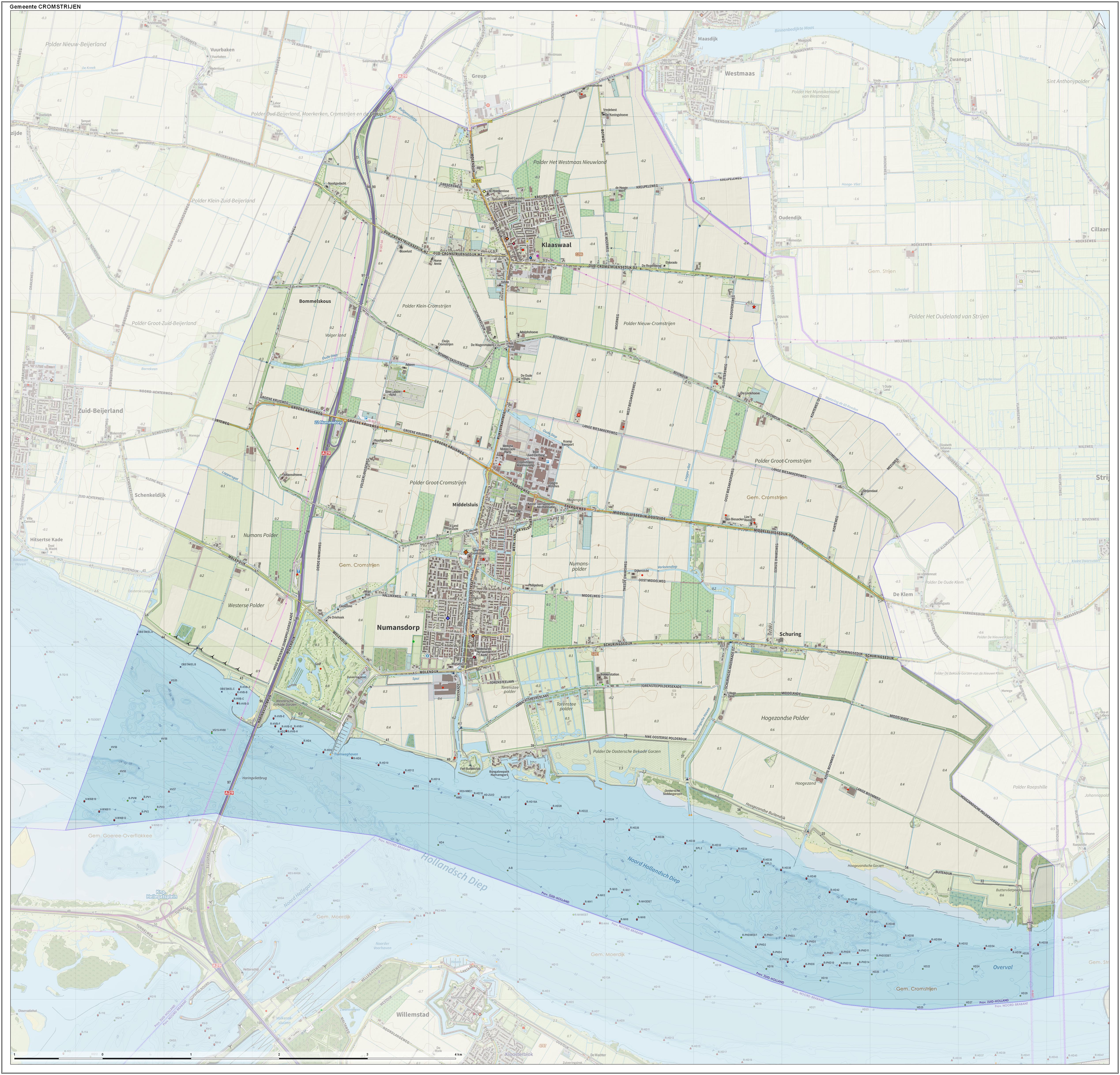
Cromstrijen (; ''Cromstrien'' in local dialect) was a municipality on the Hoeksche Waard Island in the western Netherlands , Terminology of the Low Countries, informally Holland, is a country in Northwestern Europe, with Caribbean Netherlands, overseas territories in the Caribbean. It is the largest of the four constituent countries of the Kingdom of the Nether ..., in the province of South Holland. The municipality covers an area of of which is water. It was formed on 1 January 1984, when the municipalities on the Hoeksche Waard were merged into larger municipalities. On 1 January 2019 it was merged with the municipalities of Binnenmaas, Korendijk, Oud-Beijerland, and Strijen to form the municipality of Hoeksche Waard. The municipality of Cromstrijen consists of the communities Klaaswaal and Numansdorp (townhall). Its population was in . Topography ''Dutch topographic map of the municipality of Cromstrijen, June 2015'' See also References External ... [...More Info...] [...Related Items...] OR: [Wikipedia] [Google] [Baidu] |
Hoeksche Waard (municipality)
Hoeksche Waard () is a municipality in the western Netherlands, in the province of South Holland, consisting of the eponymous Hoeksche Waard and Tiengemeten islands. The municipality was formed on 1 January 2019 by the merger of the municipalities Binnenmaas, Cromstrijen, Korendijk, Oud-Beijerland, and Strijen. Gallery File:'s-Gravendeel, de Kerk op de Heul GM1963-WN13 IMG 0979 2021-09-06 17.30.jpg, 's-Gravendeel, church: the Kerk op de Heul File:'s-Gravendeel, korenmolen het Vliegend Hert RM17406 foto3 2014-04-14 17.10.jpg, 's-Gravendeel, windmill: korenmolen het Vliegend Hert File:Westmaas, de Nederlands Hervormde kerk RM38856 IMG 0929 2021-09-06 13.38.jpg, Westmaas, reformed church File:Klaaswaal, de Nederlands Hervormde kerk RM23662 IMG 0941 2021-09-06 14.04.jpg, Klaaswaal, reformed church File:Strijen, de Grote- of Sint Lambertuskerk RM34945 IMG 0960 2021-09-06 16.04.jpg, Strijen, church: the Grote- or Sint Lambertuskerk File:Maasdam, de Kerk GM1963-WN24 IMG 0978 2 ... [...More Info...] [...Related Items...] OR: [Wikipedia] [Google] [Baidu] |
Oud-Beijerland
Oud-Beijerland () is a town and former municipality in the western Netherlands, in the province of South Holland, now a part of the Hoeksche Waard municipality. With a population of 24,575 in 2020, it is the most populous town of the Hoeksche Waard island. The town is located adjacent to the confluence of the Oude Maas and Spui River. The town of Oud-Beijerland also includes the communities Vuurbaken and Zinkweg. History After the St. Elizabeth's flood (1421), large parts of the islands Putten and Grote Waard were lost and became clay banks and salt marshes which would be inundated at high tide and be unsuitable for habitation. In subsequent centuries, portions of land would be reclaimed. Oud-Beijerland was formed in 1559 as "Beijerland" by Lamoral, Count of Egmont. He was granted the rights to this area in 1557 and had the land reclaimed. This new polder was named ''Beijerland, Moerkerken, Cromstrijen en de Greup''. Circa 1624 the smaller polders Bosschenpolder and Nieuwlan ... [...More Info...] [...Related Items...] OR: [Wikipedia] [Google] [Baidu] |


