|
Madison Limestone
The Madison Limestone is a thick sequence of mostly carbonate rocks of Mississippian age in the Rocky Mountain and Great Plains areas of the western United States. The rocks serve as an important aquifer as well as an oil reservoir in places. The Madison and its equivalent strata extend from the Black Hills of western South Dakota to western Montana and eastern Idaho, and from the Canada–United States border to western Colorado and the Grand Canyon of Arizona. Age and nomenclature The Madison is formally known as the Madison Group. In Montana, where its thickness reaches , the group is subdivided into the Mission Canyon Formation and Lodgepole Formation. Equivalents of the Madison are named the Pahasapa Limestone in the Black Hills, Leadville Limestone (Colorado), Guernsey Limestone (Wyoming), and Redwall Limestone in the Grand Canyon. The upper part of the Madison Group, the Charles Formation in the subsurface of North Dakota and northern Montana, is not strictly an equiv ... [...More Info...] [...Related Items...] OR: [Wikipedia] [Google] [Baidu] |
Sun River
The Sun River (also called the Medicine River) is a tributary of the Missouri River in the Great Plains, approximately 130 mi (209 km) long, in Montana in the United States. It rises in the Rocky Mountains in two forks, the North Fork and South Fork, which join in the Flathead National Forest above Gibson Reservoir along the county line between Teton and Lewis and Clark counties. It flows E, SE, and E away from the mountains, past Simms, Sun River, and Vaughn and joins the Missouri at Great Falls. The water of the river is used extensively for irrigation, through the Sun River Project of the United States Bureau of Reclamation. The irrigation area covers approximately 92,000 acres (372 km2). The North Fork of the Sun River begins high up in the Bob Marshall Wilderness and flows generally Southward for about until it meets up with the South Fork of the Sun River. Almost immediately the two forks flow into Gibson Reservoir, impounded by Gibson Dam. ... [...More Info...] [...Related Items...] OR: [Wikipedia] [Google] [Baidu] |
Three Forks Group
The Three Forks Group is a stratigraphical unit of Famennian age in the Williston Basin. It takes the name from the city of Three Forks, Montana, and was first described in outcrop near the city by A.C. Peale in 1893 (for the Three Forks Shale). Lithology The Three Forks Group is composed of Dolomite, mudstone and bituminous shale. Hydrocarbon production In the subsurface of the Williston Basin, the Three Forks is referred to as the Three Forks ''Formation'', which lies between the Birdbear Formation below, and the Bakken Formation above. Oil produced from the Three Forks Formation in the Williston Basin of North Dakota and south-eastern Saskatchewan is often included in production statistics with the overlying Bakken Formation. For instance, the Three Forks and Bakken were combined in estimates of potential production released by the United States Geological Survey on April 30, 2013. The estimate by the USGS projects that 7.4 billion barrels of oil can be recovered from th ... [...More Info...] [...Related Items...] OR: [Wikipedia] [Google] [Baidu] |
Tournaisian
The Tournaisian is in the ICS geologic timescale The geologic time scale, or geological time scale, (GTS) is a representation of time based on the rock record of Earth. It is a system of chronological dating that uses chronostratigraphy (the process of relating strata to time) and geochr ... the lowest stage (stratigraphy), stage or oldest age (geology), age of the Mississippian (geology), Mississippian, the oldest system (stratigraphy), subsystem of the Carboniferous. The Tournaisian age lasted from Ma to Megaannum, Ma. It is preceded by the Famennian (the uppermost stage of the Devonian) and is followed by the Viséan. Name and regional alternatives The Tournaisian was named after the Belgium, Belgian city of Tournai. It was introduced in scientific literature by Belgian geologist André Hubert Dumont in 1832. Like many Devonian and lower Carboniferous stages, the Tournaisian is a unit from West European regional stratigraphy that is now used in the official inte ... [...More Info...] [...Related Items...] OR: [Wikipedia] [Google] [Baidu] |
Redwall Limestone
The Redwall Limestone is a resistant cliff-forming unit of Mississippian age that forms prominent, red-stained cliffs in the Grand Canyon, ranging in height from to . Lithology Redwall Limestone consists predominantly of light-olive-gray to light-gray, fine- to coarse-grained, thin- to thick-bedded, often cherty, limestone. Its lower part consists of brownish-gray, interbedded finely crystalline dolomite and fine- to coarse-grained limestone with layers of white chert lenses and yellowish-gray and brownish-gray, cliff-forming, thick-bedded, fine-grained dolomite. It is divided into Horseshoe Mesa Member, Mooney Falls Member, Thunder Springs Member, and Whitmore Wash Member.Chronic, H (1983) ''Roadside Geology of Arizona.'' The Mountaineers Books, Seattle, Washington. (softcover, ) Its origins date to the Mississippian age. Contacts The upper and lower contacts of the Redwall Limestone are both unconformities. Locally, the Redwall Limestone directly overlies the unconformity ... [...More Info...] [...Related Items...] OR: [Wikipedia] [Google] [Baidu] |
Leadville Limestone
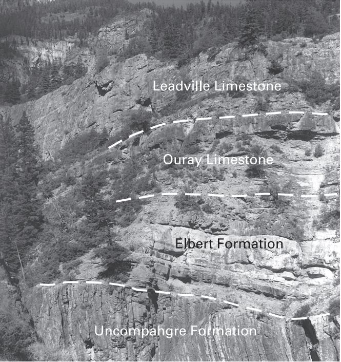
The Leadville Limestone is a Mississippian geologic formation in the western United States.Geologic map of the Marble quadrangle, Gunnison and Pitkin Counties, Colorado Gaskill, D.L., and Godwin, L.H., 1966. USGS Geologic Quadrangle Map GQ-512. Map Scale: 1:24,000. In , the upper part is oolitic , while the lower part is primarily |
Geologic Unit
A stratigraphic unit is a volume of rock of identifiable origin and relative age range that is defined by the distinctive and dominant, easily mapped and recognizable petrographic, lithologic or paleontologic features (facies) that characterize it. Units must be ''mappable'' and ''distinct'' from one another, but the contact need not be particularly distinct. For instance, a unit may be defined by terms such as "when the sandstone component exceeds 75%". Lithostratigraphic units Sequences of sedimentary and volcanic rocks are subdivided the basis of their shared or associated lithology. Formally identified lithostratigraphic units are structured in a hierarchy of lithostratigraphic rank, higher rank units generally comprising two or more units of lower rank. Going from smaller to larger in rank, the main lithostratigraphic ranks are Bed, Member, Formation, Group and Supergroup. Formal names of lithostratigraphic units are assigned by geological surveys. Units of formation or ... [...More Info...] [...Related Items...] OR: [Wikipedia] [Google] [Baidu] |
Grand Canyon
The Grand Canyon (, yuf-x-yav, Wi:kaʼi:la, , Southern Paiute language: Paxa’uipi, ) is a steep-sided canyon carved by the Colorado River in Arizona, United States. The Grand Canyon is long, up to wide and attains a depth of over a mile (). The canyon and adjacent rim are contained within Grand Canyon National Park, the Kaibab National Forest, Grand Canyon–Parashant National Monument, the Hualapai Indian Reservation, the Havasupai Indian Reservation and the Navajo Nation. President Theodore Roosevelt was a major proponent of the preservation of the Grand Canyon area and visited it on numerous occasions to hunt and enjoy the scenery. Nearly two billion years of Earth's geological history have been exposed as the Colorado River and its tributaries cut their channels through layer after layer of rock while the Colorado Plateau was uplifted. [...More Info...] [...Related Items...] OR: [Wikipedia] [Google] [Baidu] |
Canada–United States Border
The border between Canada and the United States is the longest international border in the world. The terrestrial boundary (including boundaries in the Great Lakes, Atlantic, and Pacific coasts) is long. The land border has two sections: Canada's border with the contiguous United States to its south, and with the U.S. state of Alaska to its west. The bi-national International Boundary Commission deals with matters relating to marking and maintaining the boundary, and the International Joint Commission deals with issues concerning boundary waters. The agencies currently responsible for facilitating legal passage through the international boundary are the Canada Border Services Agency (CBSA) and U.S. Customs and Border Protection (CBP). History 18th century The Treaty of Paris of 1783 ended the American Revolutionary War between Great Britain and the United States. In the second article of the Treaty, the parties agreed on all boundaries of the United States, including, ... [...More Info...] [...Related Items...] OR: [Wikipedia] [Google] [Baidu] |
Black Hills
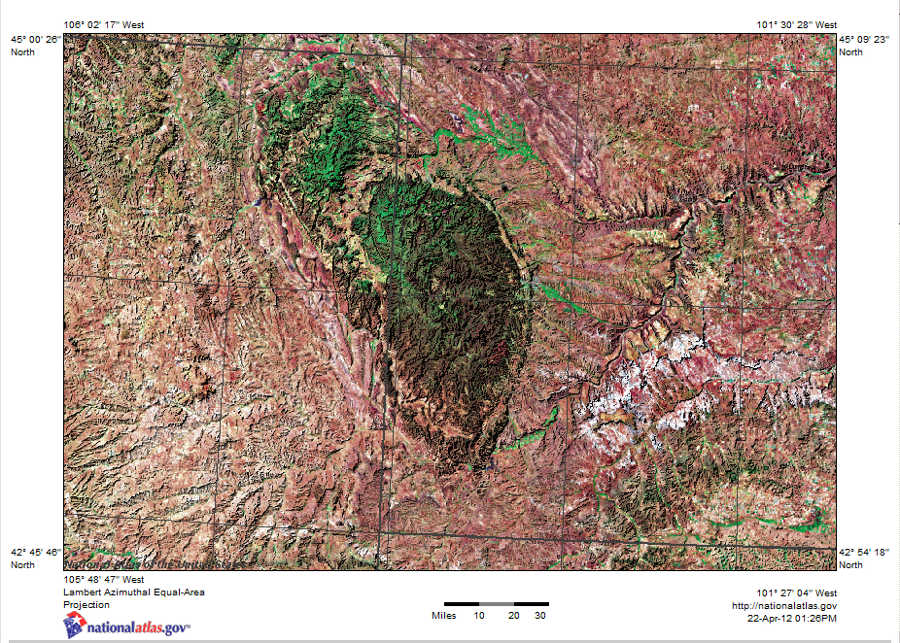
The Black Hills ( lkt, Ȟe Sápa; chy, Moʼȯhta-voʼhonáaeva; hid, awaxaawi shiibisha) is an isolated mountain range rising from the Great Plains of North America in western South Dakota and extending into Wyoming, United States. Black Elk Peak (formerly known as Harney Peak), which rises to , is the range's highest summit. The Black Hills encompass the Black Hills National Forest. The name of the hills in Lakota is ', meaning “the heart of everything that is." The Black Hills are considered a holy site. The hills are so called because of their dark appearance from a distance, as they are covered in evergreen trees. Native Americans have a long history in the Black Hills and consider it a sacred site. After conquering the Cheyenne in 1776, the Lakota took the territory of the Black Hills, which became central to their culture. In 1868, the U.S. government signed the Fort Laramie Treaty of 1868, establishing the Great Sioux Reservation west of the Missouri River, and ... [...More Info...] [...Related Items...] OR: [Wikipedia] [Google] [Baidu] |
Oil Reservoir
A petroleum reservoir or oil and gas reservoir is a subsurface accumulation of hydrocarbons contained in porous or fractured rock formations. Such reservoirs form when kerogen (ancient plant matter) is created in surrounding rock by the presence of high heat and pressure in the Earth's crust. Petroleum reservoirs are broadly classified as ''conventional'' and '' unconventional'' reservoirs. In conventional reservoirs, the naturally occurring hydrocarbons, such as crude oil or natural gas, are trapped by overlying rock formations with lower permeability, while in unconventional reservoirs, the rocks have high porosity and low permeability, which keeps the hydrocarbons trapped in place, therefore not requiring a cap rock. Reservoirs are found using hydrocarbon exploration methods. Oil field An oil field is an area of accumulation of liquid oil underground in multiple (potentially linked) reservoirs, trapped as it rises by impermeable rock formations. In industrial terms, an ... [...More Info...] [...Related Items...] OR: [Wikipedia] [Google] [Baidu] |
Aquifer
An aquifer is an underground layer of water-bearing, permeable rock, rock fractures, or unconsolidated materials ( gravel, sand, or silt). Groundwater from aquifers can be extracted using a water well. Aquifers vary greatly in their characteristics. The study of water flow in aquifers and the characterization of aquifers is called hydrogeology. Related terms include aquitard, which is a bed of low permeability along an aquifer, and aquiclude (or ''aquifuge''), which is a solid, impermeable area underlying or overlying an aquifer, the pressure of which could create a confined aquifer. The classification of aquifers is as follows: Saturated versus unsaturated; aquifers versus aquitards; confined versus unconfined; isotropic versus anisotropic; porous, karst, or fractured; transboundary aquifer. Challenges for using groundwater include: overdrafting (extracting groundwater beyond the equilibrium yield of the aquifer), groundwater-related subsidence of land, groundwater becoming ... [...More Info...] [...Related Items...] OR: [Wikipedia] [Google] [Baidu] |
United States
The United States of America (U.S.A. or USA), commonly known as the United States (U.S. or US) or America, is a country primarily located in North America. It consists of 50 states, a federal district, five major unincorporated territories, nine Minor Outlying Islands, and 326 Indian reservations. The United States is also in free association with three Pacific Island sovereign states: the Federated States of Micronesia, the Marshall Islands, and the Republic of Palau. It is the world's third-largest country by both land and total area. It shares land borders with Canada to its north and with Mexico to its south and has maritime borders with the Bahamas, Cuba, Russia, and other nations. With a population of over 333 million, it is the most populous country in the Americas and the third most populous in the world. The national capital of the United States is Washington, D.C. and its most populous city and principal financial center is New York City. Paleo-Americ ... [...More Info...] [...Related Items...] OR: [Wikipedia] [Google] [Baidu] |


