|
Kozelshchyna
Kozelschyna ( uk, ąÜąŠąĘąĄą╗čīčēąĖąĮą░) is an urban-type settlement in Poltava Oblast (province) of central Ukraine, located 77 km from Poltava. It formerly served as the administrative center of Kozelshchyna Raion, but is now administrated within Kremenchuk Raion. Population: Kozelschyna is also a railway station, and located close to the highway M22-E584. History Kozelschyna was founded in the early 18th century. In 1718, the Poltava colonel I. Chernyak sent in the Kobelyatsky region hundreds of Poltava regiment Kozaks, who then founded the settlements now belonging to the district. In 1764 attributed to Kobelyatsky company Dnieper pikinerskoho Regiment Catherine province Novorossiysk province, from 1775 to 1783 - to Novosanzharsoho County the same province, later - Oleksopolskoho, then - Poltava District Katerinoslavsky province, from 1796 - to the Little Russian province. With the formation, in 1802, of Poltava Governorate The Poltava Governorate (russian: ą¤ąŠą╗čéą░ą ... [...More Info...] [...Related Items...] OR: [Wikipedia] [Google] [Baidu] |
Kozelshchyna Raion
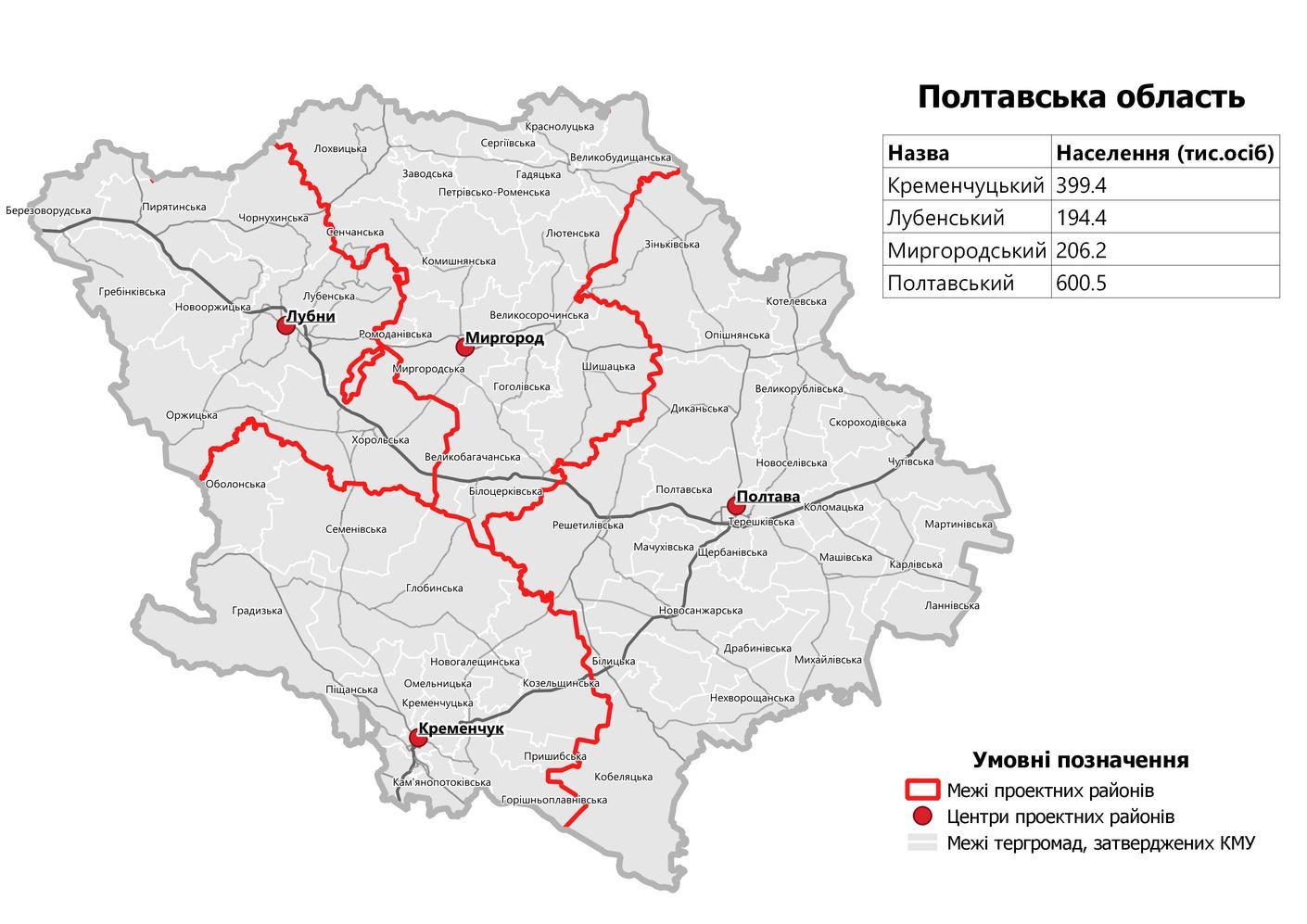
Kozelshchyna Raion ( uk, ąÜąŠąĘąĄą╗čīčēąĖąĮčüčīą║ąĖą╣ čĆą░ą╣ąŠąĮ; translit.: ''Kozelshchynskyi raion'') was a raion (district) in Poltava Oblast in central Ukraine. The raion's administrative center was the urban-type settlement of Kozelshchyna Kozelschyna ( uk, ąÜąŠąĘąĄą╗čīčēąĖąĮą░) is an urban-type settlement in Poltava Oblast (province) of central Ukraine, located 77 km from Poltava. It formerly served as the administrative center of Kozelshchyna Raion, but is now administrated with .... The other urban-type settlement in the raion was Nova Haleshchyna ( uk, ąØąŠą▓ą░ ąōą░ą╗ąĄčēąĖąĮą░). The raion was abolished and its territory was merged into Kremenchuk Raion on 18 July 2020 as part of the administrative reform of Ukraine, which reduced the number of raions of Poltava Oblast to four. The last estimate of the raion population was Important rivers within the Kozelshchyna Raion include the Psel. Settlements References External links *Kozelshchyna Raionofficial websit ... [...More Info...] [...Related Items...] OR: [Wikipedia] [Google] [Baidu] |
Poltava Oblast
Poltava Oblast ( uk, ą¤ąŠą╗čéą░╠üą▓čüčīą║ą░ ąŠ╠üą▒ą╗ą░čüčéčī, translit=Poltavska oblast; also referred to as Poltavshchyna ŌĆō uk, ą¤ąŠą╗čéą░╠üą▓čēąĖąĮą░, literally 'Poltava Country') is an oblast (province) of central Ukraine. The administrative center of the oblast is the city of Poltava. Most of its territory is part of the historic Cossack Hetmanate (its southern regions: Poltava, Myrhorod, Lubny, and Hadiach). Population: Two other important cities there are Horishni Plavni and Kremenchuk. History During the 2022 Russian Invasion of Ukraine, the town of Myrhorod was bombed. However as of April 2022, there has been no ground fighting and the province remains completely under Ukrainian control. Geography Poltava Oblast is situated in the central part of Ukraine. Located on the left bank of Dnieper, Poltava region was part of the Cossack Hetmanate. It has an area of 28,800 km2. The oblast borders upon Chernihiv, Sumy, Kharkiv, Dnipropetrovsk, Kirovohrad, Cherkasy an ... [...More Info...] [...Related Items...] OR: [Wikipedia] [Google] [Baidu] |
Countries Of The World
The following is a list providing an overview of sovereign states around the world with information on their status and recognition of their sovereignty. The 206 listed states can be divided into three categories based on membership within the United Nations System: 193 UN member states, 2 UN General Assembly non-member observer states, and 11 other states. The ''sovereignty dispute'' column indicates states having undisputed sovereignty (188 states, of which there are 187 UN member states and 1 UN General Assembly non-member observer state), states having disputed sovereignty (16 states, of which there are 6 UN member states, 1 UN General Assembly non-member observer state, and 9 de facto states), and states having a special political status (2 states, both in free association with New Zealand). Compiling a list such as this can be a complicated and controversial process, as there is no definition that is binding on all the members of the community of nations concerni ... [...More Info...] [...Related Items...] OR: [Wikipedia] [Google] [Baidu] |
Eastern European Time
Eastern European Time (EET) is one of the names of UTC+02:00 time zone, 2 hours ahead of Coordinated Universal Time. The zone uses daylight saving time, so that it uses UTC+03:00 during the summer. A number of African countries use UTC+02:00 all year long, where it is called Central Africa Time (CAT), although Egypt and Libya also use the term ''Eastern European Time''. The most populous city in the Eastern European Time zone is Cairo, with the most populous EET city in Europe being Athens. Usage The following countries, parts of countries, and territories use Eastern European Time all year round: * Egypt, since 21 April 2015; used EEST ( UTC+02:00; UTC+03:00 with daylight saving time) from 1988ŌĆō2010 and 16 MayŌĆō26 September 2014. See also Egypt Standard Time. * Kaliningrad Oblast (Russia), since 26 October 2014; also used EET in years 1945 and 1991ŌĆō2011. See also Kaliningrad Time. * Libya, since 27 October 2013; switched from Central European Time, whic ... [...More Info...] [...Related Items...] OR: [Wikipedia] [Google] [Baidu] |
Ukraine
Ukraine ( uk, ąŻą║čĆą░茹Įą░, Ukra├»na, ) is a country in Eastern Europe. It is the second-largest European country after Russia, which it borders to the east and northeast. Ukraine covers approximately . Prior to the ongoing Russian invasion, it was the eighth-most populous country in Europe, with a population of around 41 million people. It is also bordered by Belarus to the north; by Poland, Slovakia, and Hungary to the west; and by Romania and Moldova to the southwest; with a coastline along the Black Sea and the Sea of Azov to the south and southeast. Kyiv is the nation's capital and largest city. Ukraine's state language is Ukrainian; Russian is also widely spoken, especially in the east and south. During the Middle Ages, Ukraine was the site of early Slavic expansion and the area later became a key centre of East Slavic culture under the state of Kievan Rus', which emerged in the 9th century. The state eventually disintegrated into rival regional po ... [...More Info...] [...Related Items...] OR: [Wikipedia] [Google] [Baidu] |
Postal Code
A postal code (also known locally in various English-speaking countries throughout the world as a postcode, post code, PIN or ZIP Code) is a series of letters or digits or both, sometimes including spaces or punctuation, included in a postal address for the purpose of sorting mail. the Universal Postal Union lists 160 countries which require the use of a postal code. Although postal codes are usually assigned to geographical areas, special codes are sometimes assigned to individual addresses or to institutions that receive large volumes of mail, such as government agencies and large commercial companies. One example is the French CEDEX system. Terms There are a number of synonyms for postal code; some are country-specific; * CAP: The standard term in Italy; CAP is an acronym for ''codice di avviamento postale'' (postal expedition code). * CEP: The standard term in Brazil; CEP is an acronym for ''c├│digo de endere├¦amento postal'' (postal addressing code). * Eircode: ... [...More Info...] [...Related Items...] OR: [Wikipedia] [Google] [Baidu] |
Urban-type Settlement
Urban-type settlementrussian: ą┐ąŠčüčæą╗ąŠą║ ą│ąŠčĆąŠą┤čüą║ąŠ╠üą│ąŠ čéąĖ╠üą┐ą░, translit=posyolok gorodskogo tipa, abbreviated: russian: ą┐.ą│.čé., translit=p.g.t.; ua, čüąĄą╗ąĖčēąĄ ą╝č¢čüčīą║ąŠą│ąŠ čéąĖą┐čā, translit=selyshche mis'koho typu, abbreviated: uk, čü.ą╝.čé., translit=s.m.t.; be, ą┐ą░čüčæą╗ą░ą║ ą│ą░čĆą░ą┤čüą║ąŠą│ą░ čéčŗą┐čā, translit=pasiolak haradskoha typu; pl, osiedle typu miejskiego; bg, čüąĄą╗ąĖčēąĄ ąŠčé ą│čĆą░ą┤čüą║ąĖ čéąĖą┐, translit=selishte ot gradski tip; ro, a╚Öezare de tip or─ā╚Öenesc. is an official designation for a semi-urban settlement (previously called a "town"), used in several Eastern European countries. The term was historically used in Bulgaria, Poland, and the Soviet Union, and remains in use today in 10 of the post-Soviet states. The designation was used in all 15 member republics of the Soviet Union from 1922, when it replaced a number of terms that could have been translated by the English term "town" (Russia – '' posad'', Ukraine ... [...More Info...] [...Related Items...] OR: [Wikipedia] [Google] [Baidu] |
Oblasts Of Ukraine
An oblast ( uk, ąŠ╠üą▒ą╗ą░čüčéčī; ) in Ukraine, often called a region or province, is the main type of first-level administrative division of the country. Ukraine's territory is divided into 24 oblasts, as well as one autonomous republic, Crimea, and two cities with special status, Kyiv and Sevastopol. Ukraine is a unitary state, thus the oblasts do not have much legal scope of competence other than that which is established in the Ukrainian Constitution and by law. Articles 140ŌĆō146 of Chapter XI of the constitution deal directly with local authorities and their competency. Oblasts are subdivided into raions (districts), each oblast having from 3 to 10 raions following the July 2020 reform. General characteristics In Ukraine, the term ''oblast'' denotes a primary administrative division. Under the Russian Empire and into the 1920s, Ukraine was divided between several governorates. The term ''oblast'' was introduced in 1932 by Soviet authorities when the Ukrainian SSR wa ... [...More Info...] [...Related Items...] OR: [Wikipedia] [Google] [Baidu] |
Raions Of Ukraine
Raions of Ukraine (often translated as "districts"; Ukrainian: čĆą░╠üą╣ąŠąĮ, tr. ''raion''; plural: čĆą░ą╣ąŠ╠üąĮąĖ, tr. ''raiony'') are the second level of administrative division in Ukraine, below the oblast. Raions were created in a 1922 administrative reform of the Soviet Union, to which Ukraine, as the Ukrainian Soviet Socialist Republic, belonged. On 17 July 2020, the Verkhovna Rada (Ukraine's parliament) approved an administrative reform to merge most of the 490 raions, along with the " cities of regional significance", which were previously outside the raions, into just 136 reformed raions. Most tasks of the raions (education, healthcare, sport facilities, culture, and social welfare) were taken over by new hromadas, the subdivisions of raions. [...More Info...] [...Related Items...] OR: [Wikipedia] [Google] [Baidu] |
Flag Of Kremenchuk Raion
A flag is a piece of fabric (most often rectangular or quadrilateral) with a distinctive design and colours. It is used as a symbol, a signalling device, or for decoration. The term ''flag'' is also used to refer to the graphic design employed, and flags have evolved into a general tool for rudimentary signalling and identification, especially in environments where communication is challenging (such as the maritime environment, where semaphore is used). Many flags fall into groups of similar designs called flag families. The study of flags is known as "vexillology" from the Latin , meaning "flag" or "banner". National flags are patriotic symbols with widely varied interpretations that often include strong military associations because of their original and ongoing use for that purpose. Flags are also used in messaging, advertising, or for decorative purposes. Some military units are called "flags" after their use of flags. A ''flag'' (Arabic: ) is equivalent to a brigad ... [...More Info...] [...Related Items...] OR: [Wikipedia] [Google] [Baidu] |


