|
Kane Island
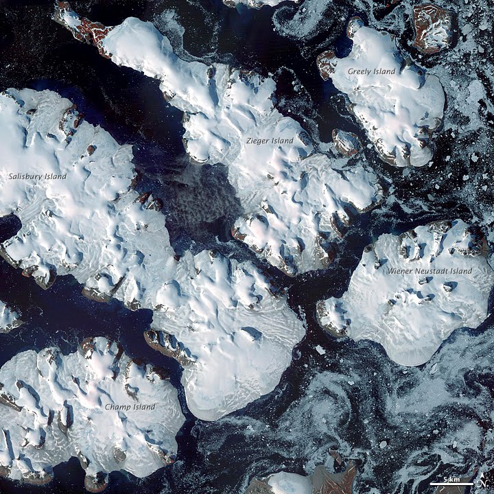
Kane Island (russian: Остров Кейна; Ostrov Keyna) is an island in Franz Josef Land, Arkhangelsk Oblast, Russian Arctic. Geography The largely unglacierised Kane island has a maximum altitude of . It is about in length, measured from north to south. The northeastern tip is called Cape Hellwald (Russian: мыс Гельвальда) while Cape Easter (Russian: мыс Пасхи) is in the southeast. The island is located on the eastern side of the central Zichy Land group within Franz Josef Land. Kuhn Island and the small Brosch Island are situated about to the northwest of Kane Island. All three islands are separated from the larger Greely Island to the southwest by the Sternek Strait (Russian: пролив Штернека). History The island was discovered by the Austro-Hungarian North Pole expedition. They first reached Cape Easter on 5 April 1874, Easter Sunday, during the second of Julius Payer's sledge journeys. On the return journey from their n ... [...More Info...] [...Related Items...] OR: [Wikipedia] [Google] [Baidu] |
Arctic
The Arctic ( or ) is a polar region located at the northernmost part of Earth. The Arctic consists of the Arctic Ocean, adjacent seas, and parts of Canada (Yukon, Northwest Territories, Nunavut), Danish Realm (Greenland), Finland, Iceland, Norway, Russia ( Murmansk, Siberia, Nenets Okrug, Novaya Zemlya), Sweden and the United States (Alaska). Land within the Arctic region has seasonally varying snow and ice cover, with predominantly treeless permafrost (permanently frozen underground ice) containing tundra. Arctic seas contain seasonal sea ice in many places. The Arctic region is a unique area among Earth's ecosystems. The cultures in the region and the Arctic indigenous peoples have adapted to its cold and extreme conditions. Life in the Arctic includes zooplankton and phytoplankton, fish and marine mammals, birds, land animals, plants and human societies. Arctic land is bordered by the subarctic. Definition and etymology The word Arctic comes from the Greek word ( ... [...More Info...] [...Related Items...] OR: [Wikipedia] [Google] [Baidu] |
Franz Josef Land
Franz Josef Land, Frantz Iosef Land, Franz Joseph Land or Francis Joseph's Land ( rus, Земля́ Фра́нца-Ио́сифа, r=Zemlya Frantsa-Iosifa, no, Fridtjof Nansen Land) is a Russian archipelago in the Arctic Ocean. It is inhabited only by military personnel. It constitutes the northernmost part of Arkhangelsk Oblast and consists of 192 islands, which cover an area of , stretching from east to west and from north to south. The islands are categorized in three groups (western, central, and eastern) separated by the British Channel and the Austrian Strait. The central group is further divided into a northern and southern section by the Markham Sound. The largest island is Prince George Land, which measures , followed by Wilczek Land, Graham Bell Island and Alexandra Land. Eighty-five percent of the archipelago is glaciated, with large unglaciated areas on the largest islands and many of the smallest ones. The islands have a combined coastline of . Compared to ot ... [...More Info...] [...Related Items...] OR: [Wikipedia] [Google] [Baidu] |
Russia
Russia (, , ), or the Russian Federation, is a transcontinental country spanning Eastern Europe and Northern Asia. It is the largest country in the world, with its internationally recognised territory covering , and encompassing one-eighth of Earth's inhabitable landmass. Russia extends across eleven time zones and shares land boundaries with fourteen countries, more than any other country but China. It is the world's ninth-most populous country and Europe's most populous country, with a population of 146 million people. The country's capital and largest city is Moscow, the largest city entirely within Europe. Saint Petersburg is Russia's cultural centre and second-largest city. Other major urban areas include Novosibirsk, Yekaterinburg, Nizhny Novgorod, and Kazan. The East Slavs emerged as a recognisable group in Europe between the 3rd and 8th centuries CE. Kievan Rus' arose as a state in the 9th century, and in 988, it adopted Orthodox Christianity from t ... [...More Info...] [...Related Items...] OR: [Wikipedia] [Google] [Baidu] |
Arkhangelsk Oblast
Arkhangelsk Oblast (russian: Арха́нгельская о́бласть, ''Arkhangelskaya oblast'') is a federal subject of Russia (an oblast). It includes the Arctic archipelagos of Franz Josef Land and Novaya Zemlya, as well as the Solovetsky Islands in the White Sea. Arkhangelsk Oblast also has administrative jurisdiction over the Nenets Autonomous Okrug (NAO). Including the NAO, Arkhangelsk Oblast has an area of 587,400 km2. Its population (including the NAO) was 1,227,626 as of the 2010 Census. The city of Arkhangelsk, with a population of 301,199 as of the 2021 Census, is the administrative center of the oblast.Charter, Article 5 The second largest city is the nearby Severodvinsk, home to Sevmash, a major shipyard for the Russian Navy. Among the oldest populated places of the oblast are Kholmogory, Kargopol, and Solvychegodsk; there are a number of Russian Orthodox monasteries, including the Antoniev Siysky Monastery and the World Heritage Site of ... [...More Info...] [...Related Items...] OR: [Wikipedia] [Google] [Baidu] |
Russian Arctic
The Extreme North or Far North (russian: Крайний Север, Дальний Север) is a large part of Russia located mainly north of the Arctic Circle and boasting enormous mineral and natural resources. Its total area is about , comprising about one-third of Russia's total area. Formally, the regions of the Extreme North comprise the whole of Chukotka Autonomous Okrug, Kamchatka Krai, Magadan Oblast, Murmansk Oblast and Sakha, as well as certain parts and cities of Arkhangelsk Oblast, Irkutsk Oblast, Khabarovsk Krai, Komi Republic, Krasnoyarsk Krai, Republic of Karelia, Sakhalin Oblast, Tuva, Tyumen Oblast, as well as all islands of the Arctic Ocean, its seas, the Bering Sea, and the Sea of Okhotsk. Due to the harsh conditions of the area, people who work there have traditionally been entitled by the Russian government to higher wages than workers of other regions. As a result of the climate and environment, the indigenous peoples of the area have developed cer ... [...More Info...] [...Related Items...] OR: [Wikipedia] [Google] [Baidu] |
Zichy Land
Zichy Land (russian: Земля Зичи; ''Zemlya Zichy'') is a geographical subgroup of Franz Josef Land, Arkhangelsk Oblast, Russia. It is formed by the central cluster of large islands in the midst of the archipelago. The islands are separated from each other by narrow sounds that are frozen most of the year, forming a compact whole. This island group was named after Hungarian Count Ödön Zichy (1811-1894) who was, beside Count Johann Nepomuk Wilczek, the second highest sponsor for the Austro-Hungarian North Pole Expedition to Franz Josef Land. Geography The broad channel to the southwest of Zichy Land is known as Markham Sound or Markham Channel (russian: Пролив маркама; Proliv Markama), after the British polar explorer Admiral Sir Albert Hastings Markham. The northernmost point of Zichy Land is Cape Bema on Karl-Alexander Island and its southernmost point is Cape Fiume on Champ Island. The distance between the two comprises . Cape Armitidzh in Luigi Is ... [...More Info...] [...Related Items...] OR: [Wikipedia] [Google] [Baidu] |
Kuhn Island
Kuhn Island ( da, Kuhn Ø) is a coastal island in Hochstetter Bay, eastern Greenland. There are coal deposits on the island. The island was discovered by the Second German North Polar Expedition (1869-1870) and is named after Franz Kuhn von Kuhnenfeld, the Austro-Hungarian minister of war, who was a patron of the expedition's cartographer, Julius von Payer. Geography This island lies to the north of Wollaston Foreland, separated from Thomas Thomsen Land in the mainland by a narrow sound, the Fligely Fjord. The Lindeman Fjord has its mouth to the southwest and the Hochstetter Bay of the Greenland Sea lies to the east. The mouths of Ardencaple Fjord and Grandjean Fjord open to the north. The islands that are located further off the shore in the bay are Shannon Island to the NE and the Pendulum Islands Little Pendulum Island ( da, Lille Pedulum Ø) is an island in Eastern Greenland, in the Northeast Greenland National Park. History The island was named by Douglas Ch ... [...More Info...] [...Related Items...] OR: [Wikipedia] [Google] [Baidu] |
Brosch Island
Greely Island (russian: Остров Грили; Ostrov Grili) is an island in Franz Josef Land, Arkhangelsk Oblast, Russia. This island was named after American Arctic explorer Adolphus Greely. Geography Greely Island's area is and it is almost completely glacierized. Greely Island is part of the Zichy Land subgroup of the Franz Josef Archipelago. It is separated from Ziegler Island by a narrow sound. Adjacent Islands Kuhn Island Kuhn Island (Russian: Остров Куна, ''Ostrov Kuna'') is a large island with unglacierized shores lying off Greely Island's northern coastline. It has a maximum height of . Brosch Island Just south of Kuhn Island lies the small Brosch Island (Russian: Остров Брош, ''Ostrov Brosh'') with a maximum height of . This island was named after Gustav Brosch, a naval lieutenant from Bohemia in the Austro-Hungarian North Pole Expedition. Kane Island Kane Island (Russian: Остров Кейна, ''Ostrov Keyna'') is another large partly ... [...More Info...] [...Related Items...] OR: [Wikipedia] [Google] [Baidu] |
Greely Island
Greely Island (russian: Остров Грили; Ostrov Grili) is an island in Franz Josef Land, Arkhangelsk Oblast, Russia. This island was named after American Arctic explorer Adolphus Greely. Geography Greely Island's area is and it is almost completely glacierized. Greely Island is part of the Zichy Land subgroup of the Franz Josef Archipelago. It is separated from Ziegler Island by a narrow sound. Adjacent Islands Kuhn Island Kuhn Island (Russian: Остров Куна, ''Ostrov Kuna'') is a large island with unglacierized shores lying off Greely Island's northern coastline. It has a maximum height of . Brosch Island Just south of Kuhn Island lies the small Brosch Island (Russian: Остров Брош, ''Ostrov Brosh'') with a maximum height of . This island was named after Gustav Brosch, a naval lieutenant from Bohemia in the Austro-Hungarian North Pole Expedition. Kane Island Kane Island (Russian: Остров Кейна, ''Ostrov Keyna'') is another large partly ... [...More Info...] [...Related Items...] OR: [Wikipedia] [Google] [Baidu] |
Austro-Hungarian North Pole Expedition
The Austro-Hungarian North Pole expedition was an Arctic expedition to find the North-East Passage that ran from 1872 to 1874 under the leadership of Julius Payer and Karl Weyprecht. The expedition discovered and partially explored Franz Josef Land. Background The Austro-Hungarian North Pole expedition was largely an initiative of geographer August Petermann who was a proponent of a navigable northern Arctic Sea. Petermann had previously been involved in the German North Pole expeditions of 1868–1870 that had failed to find navigable paths on the east coast of Greenland. Petermann then advocated for probing the area between Svalbard and Novaya Zemlya which he assumed would be less obstructed by ice due to the influence of the Gulf Stream. In 1871, a trial expedition took place. Weyprecht and Payer were put in charge. They chartered the Norwegian schooner ''Isbjørn'' and hired captain Johan Kjeldsen and a Norwegian crew in Tromsø. ''Isbjørn'' sailed to the east coast ... [...More Info...] [...Related Items...] OR: [Wikipedia] [Google] [Baidu] |
Julius Von Payer
Julius Johannes Ludovicus Ritter von Payer (2 September 1841, – 29 August 1915), ennobled Ritter von Payer in 1876, was an officer of the Austro-Hungarian Army, mountaineer, arctic explorer, cartographer, painter, and professor at the Theresian Military Academy. He is chiefly known for the Austro-Hungarian North Pole expedition in 1872–74 and the discovery of Franz Josef Land. Early life and military career Born in Schönau, Bohemia, his father Franz Anton Rudolf Payer was a retired officer of the Austrian Uhlans who died when Julius was only fourteen. His mother was Blandine, née John. Payer attended the '' k.k.'' cadet school in Łobzów near Kraków, Galicia (present-day Poland). Between 1857 and 1859 he studied at the Theresian Military Academy in Wiener Neustadt. From 1859, Payer served as a sub-lieutenant with the Austrian 36th infantry regiment in Verona, Venetia. He participated in the disastrous Battle of Solferino on 24 June 1859 and was honoured for his ... [...More Info...] [...Related Items...] OR: [Wikipedia] [Google] [Baidu] |
Elisha Kent Kane
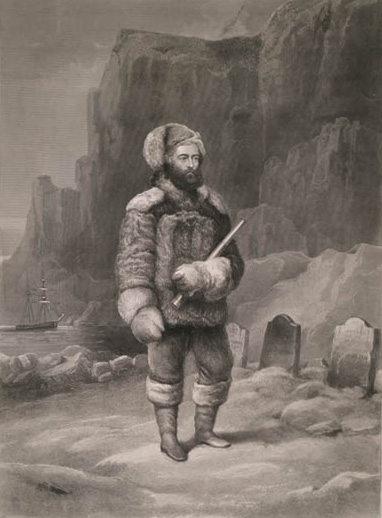
Elisha Kent Kane (February 3, 1820 – February 16, 1857) was a United States Navy medical officer and Arctic explorer. He served as assistant surgeon during Caleb Cushing's journey to China to negotiate the Treaty of Wangxia and in the Africa Squadron. He was assigned as a special envoy to the United States Army during the Mexican–American War and as a surveyor in the U.S. Coast Survey. He was senior medical officer in the First Grinnell expedition to rescue or discover the fate of the explorer Sir John Franklin. He was credited with the discovery of an encampment and gravesite from Franklin's lost expedition on Beechey Island. He led the Second Grinnell expedition to the Arctic which was unsuccessful in discovering the fate of Franklin's expedition. His explorations of the Arctic went further North than any other expeditions at the time and led to the eventual path to the North Pole taken by subsequent explorers. He spoke frequently to large audiences about his Arct ... [...More Info...] [...Related Items...] OR: [Wikipedia] [Google] [Baidu] |
_b_593.jpg)


