|
Haida Eddies
Haida Eddies are episodic, clockwise rotating ocean eddies that form during the winter off the west coast of British Columbia’s Haida Gwaii and Alaska’s Alexander Archipelago. These eddies are notable for their large size, persistence, and frequent recurrence. Rivers flowing off the North American continent supply the continental shelf in the Hecate Strait with warmer, fresher, and nutrient-enriched water. Haida eddies are formed every winter when this rapid outflow of water through the strait wraps around Cape St. James at the southern tip of Haida Gwaii, and meets with the cooler waters of the Alaska Current. This forms a series of plumes which can merge into large eddies that are shed into the northeast Pacific Ocean by late winter, and may persist for up to two years. Haida eddies can be more than 250 km in diameter, and transport a mass of coastal water approximately the volume of Lake Michigan over 1,000 km offshore into the lower nutrient waters of the northeast ... [...More Info...] [...Related Items...] OR: [Wikipedia] [Google] [Baidu] |
Geoid
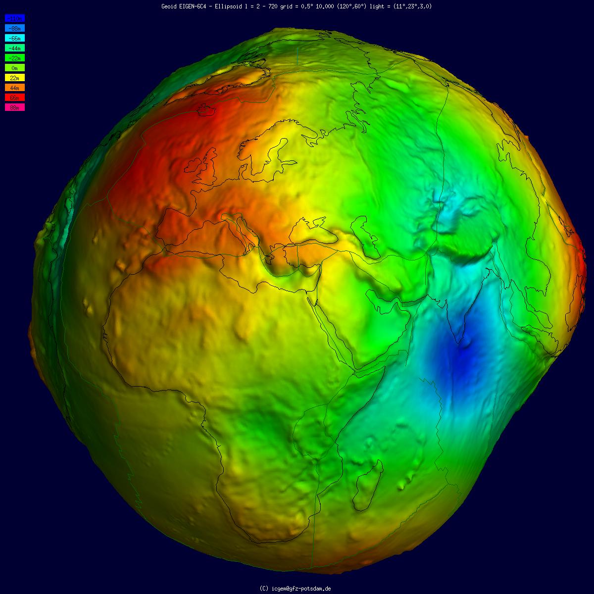
The geoid () is the shape that the ocean surface would take under the influence of the gravity of Earth, including gravitational attraction and Earth's rotation, if other influences such as winds and tides were absent. This surface is extended through the continents (such as with very narrow hypothetical canals). According to Gauss, who first described it, it is the "mathematical figure of the Earth", a smooth but irregular surface whose shape results from the uneven distribution of mass within and on the surface of Earth. It can be known only through extensive gravitational measurements and calculations. Despite being an important concept for almost 200 years in the history of geodesy and geophysics, it has been defined to high precision only since advances in satellite geodesy in the late 20th century. All points on a geoid surface have the same geopotential (the sum of gravitational potential energy and centrifugal potential energy). The force of gravity acts everywhere ... [...More Info...] [...Related Items...] OR: [Wikipedia] [Google] [Baidu] |
Columbia River
The Columbia River ( Upper Chinook: ' or '; Sahaptin: ''Nch’i-Wàna'' or ''Nchi wana''; Sinixt dialect'' '') is the largest river in the Pacific Northwest region of North America. The river rises in the Rocky Mountains of British Columbia, Canada. It flows northwest and then south into the U.S. state of Washington, then turns west to form most of the border between Washington and the state of Oregon before emptying into the Pacific Ocean. The river is long, and its largest tributary is the Snake River. Its drainage basin is roughly the size of France and extends into seven US states and a Canadian province. The fourth-largest river in the United States by volume, the Columbia has the greatest flow of any North American river entering the Pacific. The Columbia has the 36th greatest discharge of any river in the world. The Columbia and its tributaries have been central to the region's culture and economy for thousands of years. They have been used for transportation sinc ... [...More Info...] [...Related Items...] OR: [Wikipedia] [Google] [Baidu] |
Pacific Decadal Oscillation
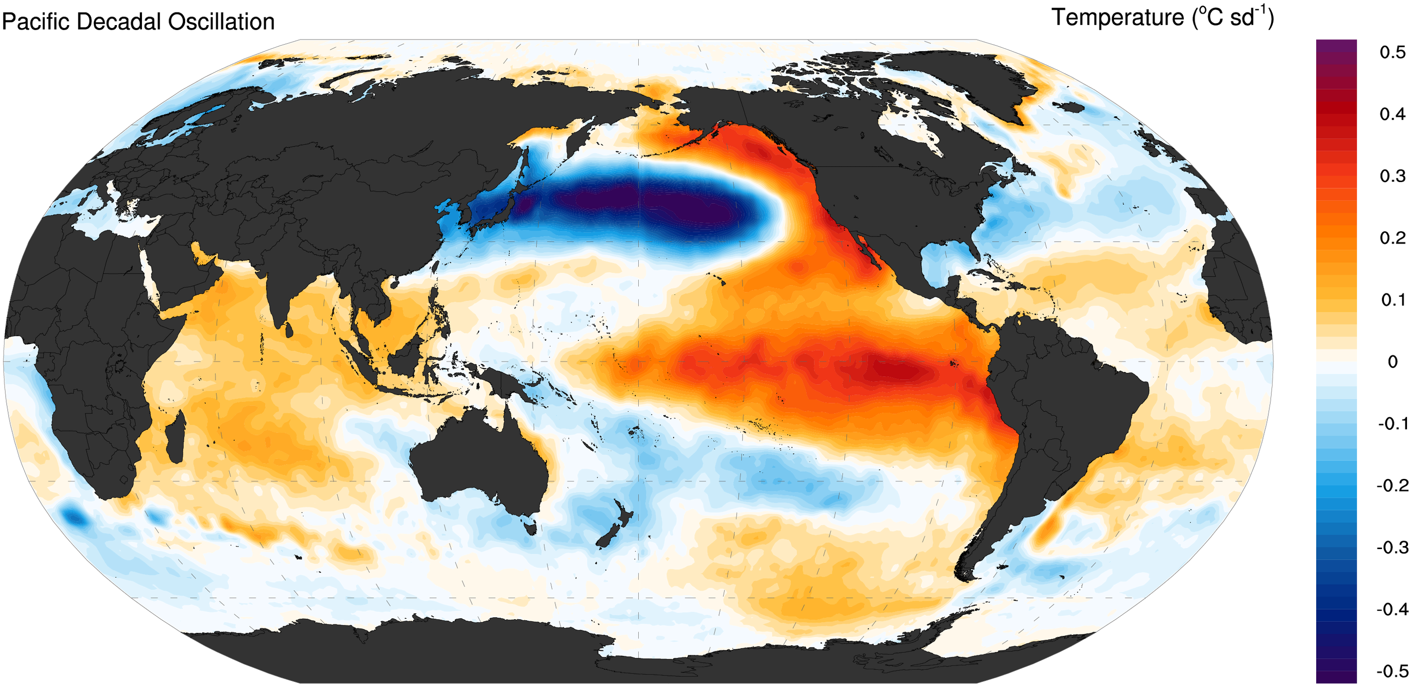
The Pacific decadal oscillation (PDO) is a robust, recurring pattern of ocean-atmosphere climate variability centered over the mid-latitude Pacific basin. The PDO is detected as warm or cool surface waters in the Pacific Ocean, north of 20°N. Over the past century, the amplitude of this climate pattern has varied irregularly at interannual-to-interdecadal time scales (meaning time periods of a few years to as much as time periods of multiple decades). There is evidence of reversals in the prevailing polarity (meaning changes in cool surface waters versus warm surface waters within the region) of the oscillation occurring around 1925, 1947, and 1977; the last two reversals corresponded with dramatic shifts in salmon production regimes in the North Pacific Ocean. This climate pattern also affects coastal sea and continental surface air temperatures from Alaska to California. During a " warm", or "positive", phase, the west Pacific becomes cooler and part of the eastern ocean warms ... [...More Info...] [...Related Items...] OR: [Wikipedia] [Google] [Baidu] |
El Niño–Southern Oscillation
El Niño–Southern Oscillation (ENSO) is an irregular periodic variation in winds and sea surface temperatures over the tropical eastern Pacific Ocean, affecting the climate of much of the tropics and subtropics. The warming phase of the sea temperature is known as ''El Niño'' and the cooling phase as '' La Niña''. The ''Southern Oscillation'' is the accompanying atmospheric component, coupled with the sea temperature change: ''El Niño'' is accompanied by high air surface pressure in the tropical western Pacific and ''La Niña'' with low air surface pressure there. The two periods last several months each and typically occur every few years with varying intensity per period. The two phases relate to the Walker circulation, which was discovered by Gilbert Walker during the early twentieth century. The Walker circulation is caused by the pressure gradient force that results from a high-pressure area over the eastern Pacific Ocean, and a low-pressure system over Indonesia. ... [...More Info...] [...Related Items...] OR: [Wikipedia] [Google] [Baidu] |
California Current
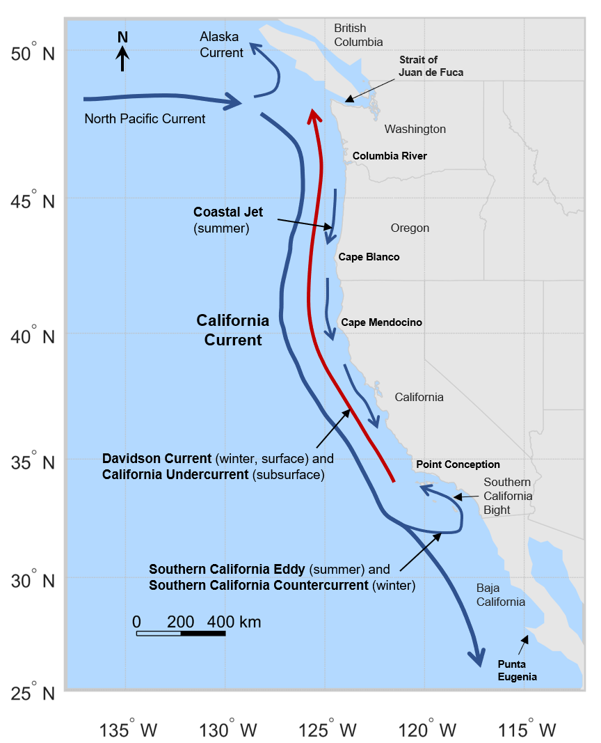
The California Current is a cold water Pacific Ocean current that moves southward along the western coast of North America, beginning off southern British Columbia and ending off southern Baja California Sur. It is considered an Eastern boundary current due to the influence of the North American coastline on its course. It is also one of five major coastal currents affiliated with strong upwelling zones, the others being the Humboldt Current, the Canary Current, the Benguela Current, and the Somali Current. The California Current is part of the North Pacific Gyre, a large swirling current that occupies the northern basin of the Pacific. Physical properties The movement of Alaskan and northern ocean currents southward down the west coast results in much cooler ocean temperatures than at comparable latitudes on the east coast of the United States, where ocean currents come from the Caribbean and tropical Atlantic. The cooler ocean current along the west coast also makes summ ... [...More Info...] [...Related Items...] OR: [Wikipedia] [Google] [Baidu] |
Ocean Gyre
In oceanography, a gyre () is any large system of circulating ocean currents, particularly those involved with large wind movements. Gyres are caused by the Coriolis effect; planetary vorticity, horizontal friction and vertical friction determine the circulatory patterns from the '' wind stress curl'' (torque). ''Gyre'' can refer to any type of vortex in an atmosphere or a sea, even one that is human-created, but it is most commonly used in terrestrial oceanography to refer to the major ocean systems. Major gyres The following are the five most notable ocean gyres:The five most notable gyres PowerPoint Presentation * Indian Ocean Gyre * [...More Info...] [...Related Items...] OR: [Wikipedia] [Google] [Baidu] |
North Pacific Current
The North Pacific Current (sometimes referred to as the North Pacific Drift) is a slow warm water current that flows west-to-east between 30 and 50 degrees north in the Pacific Ocean. The current forms the southern part of the North Pacific Subpolar Gyre and the northern part of the North Pacific Subtropical Gyre. The North Pacific Current is formed by the collision of the Kuroshio Current, running northward off the coast of Japan, and the Oyashio Current, which is a cold subarctic current that flows south and circulates counterclockwise along the western North Pacific Ocean. In the eastern North Pacific off southern British Columbia, it splits into the southward flowing cold water California Current and the northward flowing Alaska Current. Flows and temperature Originating from the eastward directed flow occurring east of the island of Honshu, Japan, the North Pacific Current extends over 40° of longitude. According to the Great Soviet Encyclopedia, the NPC may be considere ... [...More Info...] [...Related Items...] OR: [Wikipedia] [Google] [Baidu] |
North Pacific Gyre
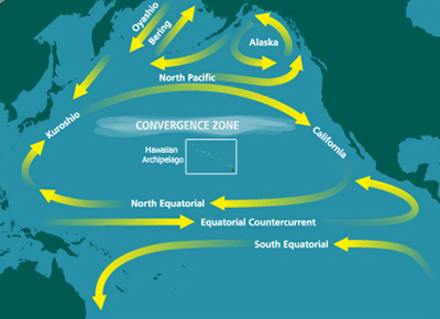
The North Pacific Gyre (NPG) or North Pacific Subtropical Gyre (NPSG), located in the northern Pacific Ocean, is one of the five major oceanic gyres. This gyre covers most of the northern Pacific Ocean. It is the largest ecosystem on Earth, located between the equator and 50° N latitude, and comprising 20 million square kilometers. The gyre has a clockwise circular pattern and is formed by four prevailing ocean currents: the North Pacific Current to the north, the California Current to the east, the North Equatorial Current to the south, and the Kuroshio Current to the west. It is the site of an unusually intense collection of human-created marine debris, known as the Great Pacific Garbage Patch. The North Pacific Subtropical Gyre and the much smaller North Pacific Subpolar Gyre make up the two major gyre systems in the mid-latitudes of the Northern Pacific Ocean. This two-gyre circulation in the North Pacific is driven by the trade and westerly winds. This is one of the bes ... [...More Info...] [...Related Items...] OR: [Wikipedia] [Google] [Baidu] |
National Oceanic And Atmospheric Administration
The National Oceanic and Atmospheric Administration (abbreviated as NOAA ) is an United States scientific and regulatory agency within the United States Department of Commerce that forecasts weather, monitors oceanic and atmospheric conditions, charts the seas, conducts deep sea exploration, and manages fishing and protection of marine mammals and endangered species in the U.S. exclusive economic zone. Purpose and function NOAA's specific roles include: * ''Supplying Environmental Information Products''. NOAA supplies to its customers and partners information pertaining to the state of the oceans and the atmosphere, such as weather warnings and forecasts via the National Weather Service. NOAA's information services extend as well to climate, ecosystems, and commerce. * ''Providing Environmental Stewardship Services''. NOAA is a steward of U.S. coastal and marine environments. In coordination with federal, state, local, tribal and international authorities, NOAA manages th ... [...More Info...] [...Related Items...] OR: [Wikipedia] [Google] [Baidu] |
Institute Of Ocean Sciences
The Institute of Ocean Sciences is operated by Fisheries and Oceans Canada and is one of the largest marine research centres in Canada. It is located on Patricia Bay and the former British Columbia Highway 17A in Sidney, British Columbia on Vancouver Island just west of Victoria International Airport. The institute is paired with a Canadian Coast Guard The Canadian Coast Guard (CCG; french: links=no, Garde côtière canadienne, GCC) is the coast guard of Canada. Formed in 1962, the coast guard is tasked with marine search and rescue (SAR), communication, navigation, and transportation issues ... base, and makes use of the ships and as well as the Japanese . ReferencesFisheries and Oceans Canada: IOS [...More Info...] [...Related Items...] OR: [Wikipedia] [Google] [Baidu] |
European Remote-Sensing Satellite
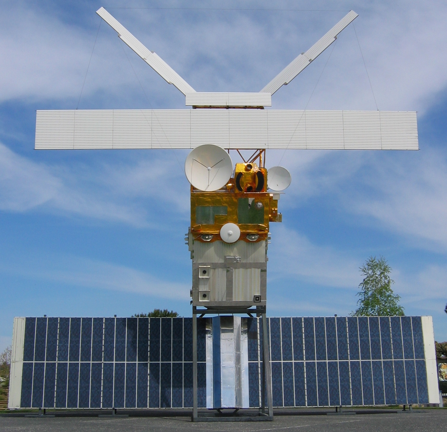
European Remote Sensing satellite (ERS) was the European Space Agency's first Earth-observing satellite programme using a polar orbit. It consisted of 2 satellites, ERS-1 and ERS-2. ERS-1 ERS-1 launched 17 July 1991 from Guiana Space Centre aboard an Ariane 4 rocket. The satellite was put into a Sun-synchronous polar orbit at an altitude of 782–785 km. ERS-1 failed on 10 March 2000 after nine years in orbit. Instruments ERS-1 carried an array of Earth-observation instruments that gathered information about the Earth (land, water, ice and atmosphere) using a variety of measurement principles. These included: * RA (Radar Altimeter) is a single frequency nadir-pointing radar altimeter operating in the Ku band. * ATSR-1 ( Along-Track Scanning Radiometer) is a 4 channel infrared radiometer and microwave sounder for measuring temperatures at the sea-surface and the top of clouds. * SAR (synthetic-aperture radar) operating in C band can detect changes in surface ... [...More Info...] [...Related Items...] OR: [Wikipedia] [Google] [Baidu] |

