|
European Remote-Sensing Satellite
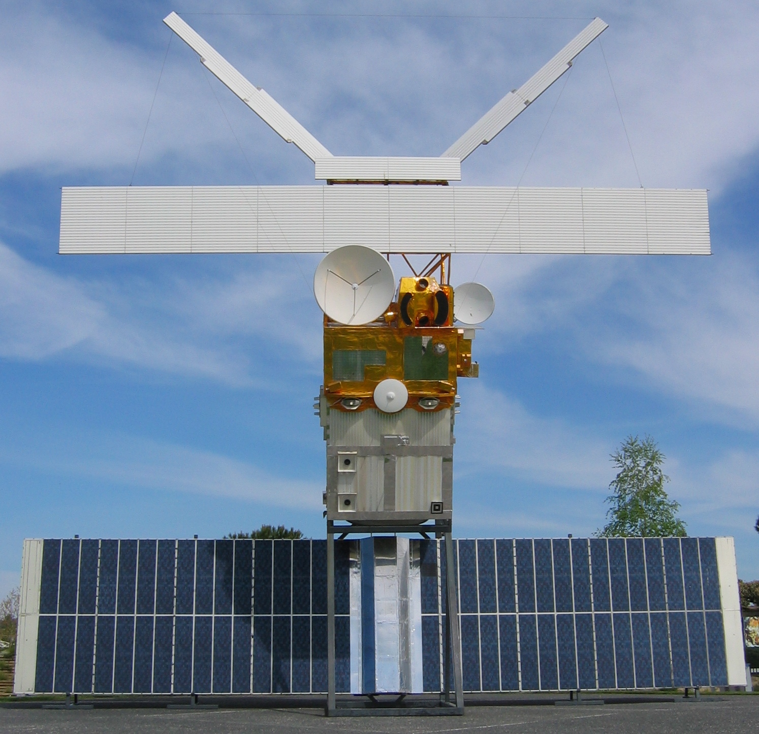
European Remote Sensing satellite (ERS) was the European Space Agency's first Earth-observing satellite programme using a polar orbit. It consisted of 2 satellites, ERS-1 and ERS-2. ERS-1 ERS-1 launched 17 July 1991 from Guiana Space Centre aboard an Ariane 4 rocket. The satellite was put into a Sun-synchronous polar orbit at an altitude of 782–785 km. ERS-1 failed on 10 March 2000 after nine years in orbit. Instruments ERS-1 carried an array of Earth-observation instruments that gathered information about the Earth (land, water, ice and atmosphere) using a variety of measurement principles. These included: * RA (Radar Altimeter) is a single frequency nadir-pointing radar altimeter operating in the Ku band. * ATSR-1 ( Along-Track Scanning Radiometer) is a 4 channel infrared radiometer and microwave sounder for measuring temperatures at the sea-surface and the top of clouds. * SAR (synthetic-aperture radar) operating in C band can detect changes in surface ... [...More Info...] [...Related Items...] OR: [Wikipedia] [Google] [Baidu] |
ERS 2
European Remote Sensing satellite (ERS) was the European Space Agency's first Earth-observing satellite programme using a polar orbit. It consisted of 2 satellites, ERS-1 and ERS-2. ERS-1 ERS-1 launched 17 July 1991 from Guiana Space Centre aboard an Ariane 4 rocket. The satellite was put into a Sun-synchronous polar orbit at an altitude of 782–785 km. ERS-1 failed on 10 March 2000 after nine years in orbit. Instruments ERS-1 carried an array of Earth-observation instruments that gathered information about the Earth (land, water, ice and atmosphere) using a variety of measurement principles. These included: * RA (Radar Altimeter) is a single frequency nadir-pointing radar altimeter operating in the Ku band. * ATSR-1 ( Along-Track Scanning Radiometer) is a 4 channel infrared radiometer and microwave sounder for measuring temperatures at the sea-surface and the top of clouds. * SAR (synthetic-aperture radar) operating in C band can detect changes in surface height ... [...More Info...] [...Related Items...] OR: [Wikipedia] [Google] [Baidu] |
Synthetic-aperture Radar
Synthetic-aperture radar (SAR) is a form of radar that is used to create two-dimensional images or three-dimensional reconstructions of objects, such as landscapes. SAR uses the motion of the radar antenna over a target region to provide finer spatial resolution than conventional stationary beam-scanning radars. SAR is typically mounted on a moving platform, such as an aircraft or spacecraft, and has its origins in an advanced form of side looking airborne radar (SLAR). The distance the SAR device travels over a target during the period when the target scene is illuminated creates the large ''synthetic'' antenna aperture (the ''size'' of the antenna). Typically, the larger the aperture, the higher the image resolution will be, regardless of whether the aperture is physical (a large antenna) or synthetic (a moving antenna) – this allows SAR to create high-resolution images with comparatively small physical antennas. For a fixed antenna size and orientation, objects which ... [...More Info...] [...Related Items...] OR: [Wikipedia] [Google] [Baidu] |
Kourou
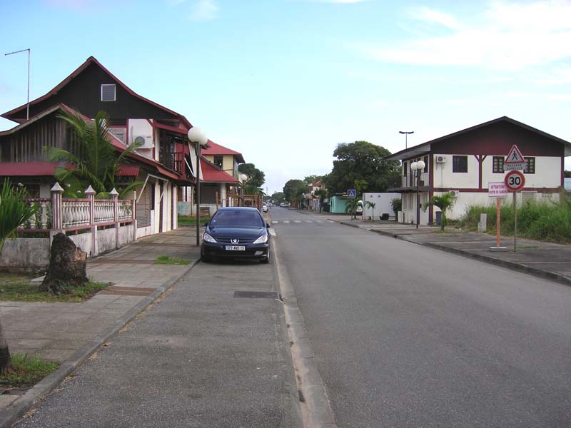
Kourou () is a commune in French Guiana, an overseas region and department of France in South America. Kourou is famous for being the location of the Guiana Space Centre, the main spaceport of France and the European Space Agency (ESA). It is an administrative district in French Guiana and the main town there. Geography Some northwest of the French Guianese capital Cayenne the Kourou River empties into the Atlantic Ocean. At the mouth of this river sits the town of Kourou, which is ringed by four hills: Carapa, Pariacabo, Café and Lombard, with the Singes and Condamine mountains not far behind. There are three lakes within the town's city limits: Lake Bois Diable (where one can take lessons in jetski and other aquatic sports), Lake Marie-Claire (the smallest and calmest), and Lake Bois Chaudat (the biggest of the three; also open to sport lovers, especially canoers and kayakers). Long white sand beaches and some rocky outcrops line the town's ocean coast, the riverbank ... [...More Info...] [...Related Items...] OR: [Wikipedia] [Google] [Baidu] |
Gyroscope
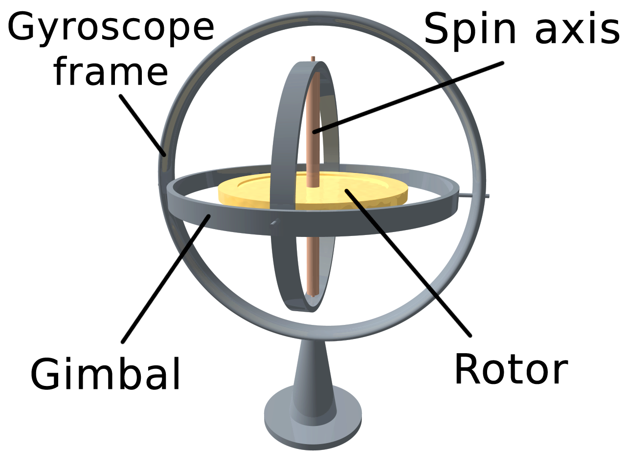
A gyroscope (from Ancient Greek γῦρος ''gŷros'', "round" and σκοπέω ''skopéō'', "to look") is a device used for measuring or maintaining orientation and angular velocity. It is a spinning wheel or disc in which the axis of rotation (spin axis) is free to assume any orientation by itself. When rotating, the orientation of this axis is unaffected by tilting or rotation of the mounting, according to the conservation of angular momentum. Gyroscopes based on other operating principles also exist, such as the microchip-packaged MEMS gyroscopes found in electronic devices (sometimes called gyrometers), solid-state ring lasers, fibre optic gyroscopes, and the extremely sensitive quantum gyroscope. Applications of gyroscopes include inertial navigation systems, such as in the Hubble Space Telescope, or inside the steel hull of a submerged submarine. Due to their precision, gyroscopes are also used in gyrotheodolites to maintain direction in tunnel mining. Gyroscope ... [...More Info...] [...Related Items...] OR: [Wikipedia] [Google] [Baidu] |
Attitude Control
Attitude control is the process of controlling the orientation of an aerospace vehicle with respect to an inertial frame of reference or another entity such as the celestial sphere, certain fields, and nearby objects, etc. Controlling vehicle attitude requires sensors to measure vehicle orientation, actuators to apply the torques needed to orient the vehicle to a desired attitude, and algorithms to command the actuators based on (1) sensor measurements of the current attitude and (2) specification of a desired attitude. The integrated field that studies the combination of sensors, actuators and algorithms is called guidance, navigation and control (GNC). Aircraft attitude control An aircraft's attitude is stabilized in three directions: '' yaw'', nose left or right about an axis running up and down; ''pitch'', nose up or down about an axis running from wing to wing; and ''roll'', rotation about an axis running from nose to tail. Elevators (moving flaps on the horizontal t ... [...More Info...] [...Related Items...] OR: [Wikipedia] [Google] [Baidu] |
Geoid
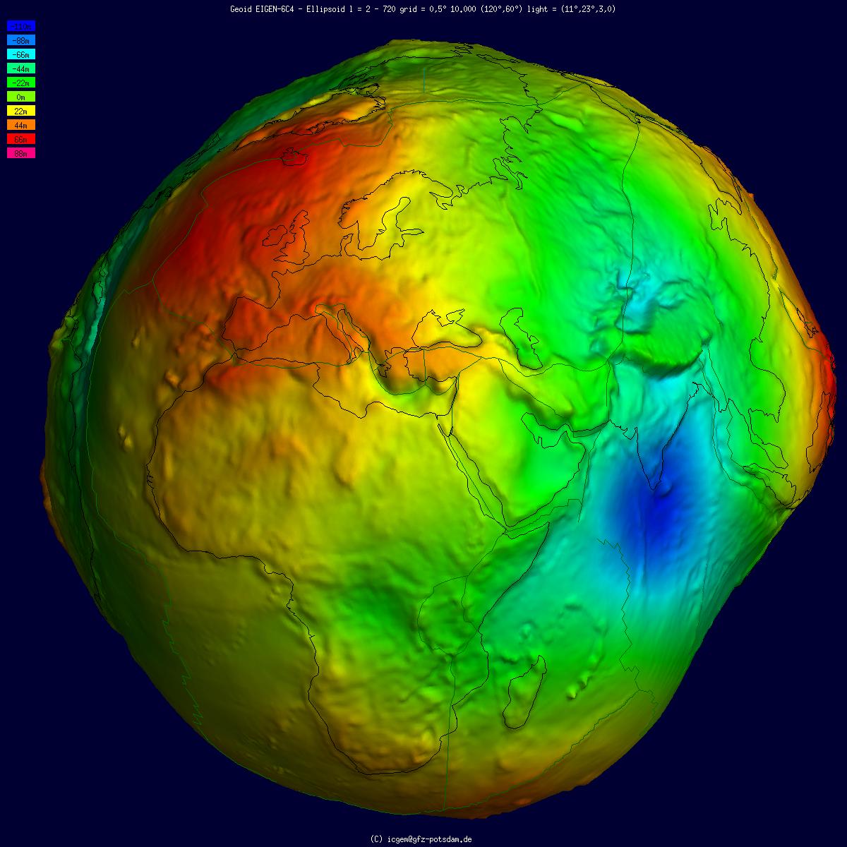
The geoid () is the shape that the ocean surface would take under the influence of the gravity of Earth, including gravitational attraction and Earth's rotation, if other influences such as winds and tides were absent. This surface is extended through the continents (such as with very narrow hypothetical canals). According to Gauss, who first described it, it is the "mathematical figure of the Earth", a smooth but irregular surface whose shape results from the uneven distribution of mass within and on the surface of Earth. It can be known only through extensive gravitational measurements and calculations. Despite being an important concept for almost 200 years in the history of geodesy and geophysics, it has been defined to high precision only since advances in satellite geodesy in the late 20th century. All points on a geoid surface have the same geopotential (the sum of gravitational potential energy and centrifugal potential energy). The force of gravity acts everywhere ... [...More Info...] [...Related Items...] OR: [Wikipedia] [Google] [Baidu] |
Bathymetry
Bathymetry (; ) is the study of underwater depth of ocean floors (''seabed topography''), lake floors, or river floors. In other words, bathymetry is the underwater equivalent to hypsometry or topography. The first recorded evidence of water depth measurements are from Ancient Egypt over 3000 years ago. Bathymetric (or hydrographic) charts are typically produced to support safety of surface or sub-surface navigation, and usually show seafloor relief or terrain as contour lines (called depth contours or isobaths) and selected depths ('' soundings''), and typically also provide surface navigational information. Bathymetric maps (a more general term where navigational safety is not a concern) may also use a Digital Terrain Model and artificial illumination techniques to illustrate the depths being portrayed. The global bathymetry is sometimes combined with topography data to yield a global relief model. Paleobathymetry is the study of past underwater depths. Seabed topogr ... [...More Info...] [...Related Items...] OR: [Wikipedia] [Google] [Baidu] |
Altimeter
An altimeter or an altitude meter is an instrument used to measure the altitude of an object above a fixed level. The measurement of altitude is called altimetry, which is related to the term bathymetry, the measurement of depth under water. The most common unit for altimeter calibration worldwide is hectopascals (hPa), except for North America (other than Canada ) and Japan where inches of mercury (inHg) are used. To obtain an accurate altitude reading in either feet or meters, the local barometric pressure must be calibrated correctly using the barometric formula. History The scientific principles behind the altimeter were first written by Rev. Alexander Bryce a Scottish minister and astronomer in 1772 who realised that the principles of a barometer could be adjusted to measure height. Pressure altimeter Altitude can be determined based on the measurement of atmospheric pressure. The greater the altitude, the lower the pressure. When a barometer is supplied with a nonlinear ... [...More Info...] [...Related Items...] OR: [Wikipedia] [Google] [Baidu] |
Radar
Radar is a detection system that uses radio waves to determine the distance ('' ranging''), angle, and radial velocity of objects relative to the site. It can be used to detect aircraft, ships, spacecraft, guided missiles, motor vehicles, weather formations, and terrain. A radar system consists of a transmitter producing electromagnetic waves in the radio or microwaves domain, a transmitting antenna, a receiving antenna (often the same antenna is used for transmitting and receiving) and a receiver and processor to determine properties of the objects. Radio waves (pulsed or continuous) from the transmitter reflect off the objects and return to the receiver, giving information about the objects' locations and speeds. Radar was developed secretly for military use by several countries in the period before and during World War II. A key development was the cavity magnetron in the United Kingdom, which allowed the creation of relatively small systems with sub-meter resolution. Th ... [...More Info...] [...Related Items...] OR: [Wikipedia] [Google] [Baidu] |
Radiation Hardening
Radiation hardening is the process of making electronic components and circuits resistant to damage or malfunction caused by high levels of ionizing radiation ( particle radiation and high-energy electromagnetic radiation), especially for environments in outer space (especially beyond the low Earth orbit), around nuclear reactors and particle accelerators, or during nuclear accidents or nuclear warfare. Most semiconductor electronic components are susceptible to radiation damage, and radiation-hardened (rad-hard) components are based on their non-hardened equivalents, with some design and manufacturing variations that reduce the susceptibility to radiation damage. Due to the extensive development and testing required to produce a radiation-tolerant design of a microelectronic chip, the technology of radiation-hardened chips tends to lag behind the most recent developments. Radiation-hardened products are typically tested to one or more resultant-effects tests, including total ... [...More Info...] [...Related Items...] OR: [Wikipedia] [Google] [Baidu] |
Retroreflector
A retroreflector (sometimes called a retroflector or cataphote) is a device or surface that reflection (physics), reflects radiation (usually light) back to its source with minimum scattering. This works at a wide range of angle of incidence (optics), angle of incidence, unlike a planar mirror, which does this only if the mirror is exactly perpendicular to the wave front, having a zero angle of incidence. Being directed, the retroflector's reflection is brighter than that of a diffuse reflector. Corner reflectors and Cat's eye (road), cat's eye reflectors are the most used kinds. Types There are several ways to obtain retroreflection: Corner reflector A set of three mutually perpendicular reflective surfaces, placed to form the internal corner of a cube, work as a retroreflector. The three corresponding normal vectors of the corner's sides form a basis in which to represent the direction of an arbitrary incoming ray, . When the ray reflects from the first side, say x, the ... [...More Info...] [...Related Items...] OR: [Wikipedia] [Google] [Baidu] |
Laser
A laser is a device that emits light through a process of optical amplification based on the stimulated emission of electromagnetic radiation. The word "laser" is an acronym for "light amplification by stimulated emission of radiation". The first laser was built in 1960 by Theodore H. Maiman at Hughes Research Laboratories, based on theoretical work by Charles Hard Townes and Arthur Leonard Schawlow. A laser differs from other sources of light in that it emits light which is ''coherent''. Spatial coherence allows a laser to be focused to a tight spot, enabling applications such as laser cutting and lithography. Spatial coherence also allows a laser beam to stay narrow over great distances (collimation), enabling applications such as laser pointers and lidar (light detection and ranging). Lasers can also have high temporal coherence, which allows them to emit light with a very narrow spectrum. Alternatively, temporal coherence can be used to produce ultrashort pulses ... [...More Info...] [...Related Items...] OR: [Wikipedia] [Google] [Baidu] |


