|
Drina Banovina
The Drina Banovina or Drina Banate ( sh-Latn-Cyrl, separator=" / ", Drinska banovina, Дринска бановина), was a province ( banovina) of the Kingdom of Yugoslavia between 1929 and 1941. Its capital was Sarajevo and it included portions of present-day Bosnia and Herzegovina and Serbia. It was named after the Drina River and, like all Yugoslav banovinas, was intentionally not based on ethnic boundaries. As a result of the creation of the Banovina of Croatia in 1939, its territory was reduced considerably. Borders According to the 1931 Constitution of the Kingdom of Yugoslavia, Demographics According to the Yugoslav census of 1931, the Drina banovina had a population of 1,534,739 and a population density of 55.1 people per square kilometre. The census also says that Drina banovina had a high agricultural population, with an agricultural population of 91.3 people per square kilometre. This was the second highest agricultural population density in the country behi ... [...More Info...] [...Related Items...] OR: [Wikipedia] [Google] [Baidu] |
Subdivisions Of The Kingdom Of Yugoslavia
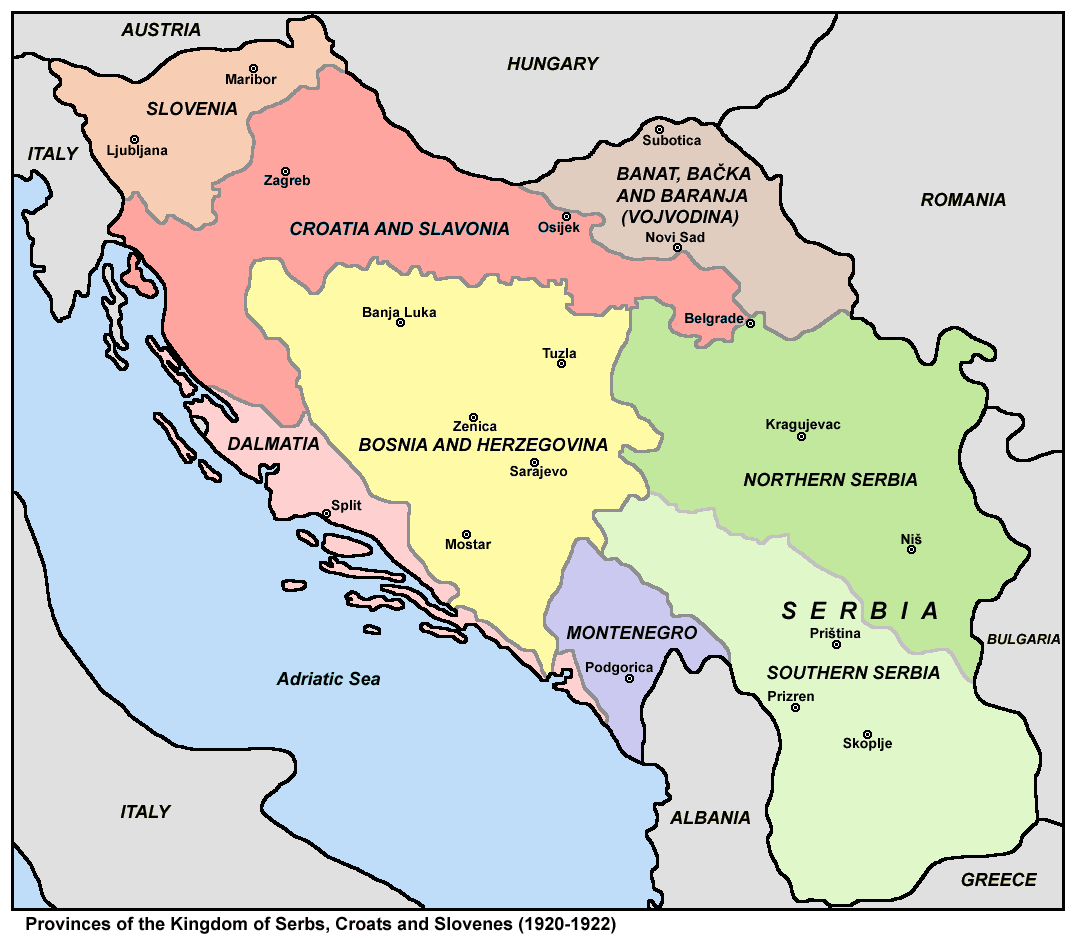
The subdivisions of the Kingdom of Yugoslavia (initially known as the Kingdom of Serbs, Croats, and Slovenes) existed successively in three different forms. From 1918 to 1922, the kingdom maintained the pre-World War I subdivisions of Yugoslavia's predecessor states. In 1922, the state was divided into 33 ''oblasts'' or provinces and, in 1929, a new system of nine banates (in Serbo-Croatian, the word for "banate" is ''banovina'') was implemented. Pre-Yugoslav subdivisions (1918–1922) From 1918 to 1922, Kingdom of Serbs, Croats, and Slovenes continued to be subdivided into the pre-World War I divisions of Austria-Hungary and the formerly independent kingdoms of Serbia and Montenegro. Provinces (''pokrajine'') were: # Slovenia # Croatia and Slavonia # Dalmatia # Bosnia and Herzegovina # Banat, Bačka and Baranja # Serbia ## Northern Serbia ## Southern Serbia # Montenegro These were subdivided into districts and counties: # District of Andrijevica (former Montenegro) # Distri ... [...More Info...] [...Related Items...] OR: [Wikipedia] [Google] [Baidu] |
Treskavica
Treskavica ( sr-cyrl, Трескавица) is a mountain range in Bosnia and Herzegovina, situated in Trnovo municipality just south of city of Sarajevo. Mala Ćaba (Đokin Toranj) peak at 2088 m (6850 ft.), which makes Treskavica the tallest of all the mountains circling Sarajevo, and only some 300 m shorter than the tallest mountain in the country. On clear days with good weather, climbers can see far into the distance, up to Montenegro and the Adriatic Sea. Topography Geologically, the Treskavica range is part of the Dinaric Alps and formed largely of secondary and tertiary sedimentary rock, mostly limestone and dolomite. A number of beautiful mountain lakes are scattered throughout the group, of which Veliko Jezero is the largest. A number of streams source from these mountains: the Bistrica tributary of the Drina river, the Željeznica tributary of the Bosna river, Ljuta and Rakitnica tributaries of the Neretva. Notable peaks are Mala Ćaba (2088 m.), Pašina Planina ... [...More Info...] [...Related Items...] OR: [Wikipedia] [Google] [Baidu] |
Čajniče
Čajniče ( sr-cyr, Чајниче, ) is a town and municipality located in Republika Srpska, an entity of Bosnia and Herzegovina. As of 2013, the town has a population of 2,401 inhabitants, while the municipality has 4,895 inhabitants. Settlements Aside from the town of Čajniče, the municipality includes the following settlements: * Avlija * Batkovići * Batotići * Batovo * Bezujno * Borajno * Brezovice * Bučkovići na Bezujanci * Đakovići * Glamočevići * Gložin * Hunkovići * Ifsar * Kamen * Kapov Han * Karovići * Krstac * Lađevci * Luke * Međurječje * Metaljka * Milatkovići * Miljeno * Mištar * Podavrelo * Ponikve * Prvanj * Slatina * Staronići * Stopići * Sudići * Todorovići * Trpinje * Tubrojevići * Zaborak Demographics Population Ethnic composition Notable people * Hanka Paldum, Bosnian singer See also *Municipalities of Republika Srpska Under the "Law on Territorial Organization and Local Self-Government" ... [...More Info...] [...Related Items...] OR: [Wikipedia] [Google] [Baidu] |
Višegrad
Višegrad ( sr-cyrl, Вишеград, ) is a town and municipality located in eastern Republika Srpska, an entity of Bosnia and Herzegovina. It rests at the confluence of the Drina and the Rzav river. As of 2013, it has a population of 10,668 inhabitants, while the town of Višegrad has a population of 5,869 inhabitants. The town includes the Ottoman-era Mehmed Paša Sokolović Bridge, a UNESCO world heritage site which was popularized by Ivo Andrić in his novel '' The Bridge on the Drina''. A tourist site called '' Andrićgrad (Andrić Town)'', dedicated to Andrić, is located near the bridge. Etymology Višegrad is a South Slavic toponym meaning "the upper town/castle/fort". Geography Višegrad is located at the confluence of the Drina river and the Rzav river in eastern Bosnia and Herzegovina, on the road from Goražde and Ustiprača towards Užice, Serbia, which is part of the geographical region of Podrinje. It is also part of the historical region of Stari Vlah; ... [...More Info...] [...Related Items...] OR: [Wikipedia] [Google] [Baidu] |
Zlatibor
Zlatibor ( sr-cyr, Златибoр ) is a mountainous region situated in the western part of Serbia. Among the most popular places in Serbia for tourism, Zlatibor's main attractions include health tourism, skiing, and hiking and the longest panoramic gondola lift in the world. Tornik ski resort is located in the area. The largest city in the region is Užice—located at the foothills of the mountain—while most of the area belongs to the municipality of Čajetina. The town of Zlatibor has changed over the years from a group of vacation homes to an urban location with diverse amenities. The Zlatibor region is divided among two municipalities, Čajetina and Užice, while both lie within the Zlatibor District. The Belgrade-Bar railroad passes through Zlatibor. History In the Middle Ages, the region was known as Rujno, a ''župa'' that was part of Raška, a centre of the medieval Serbian state. The name ''Zlatibor'' came into the 18th century, but its etymology is unc ... [...More Info...] [...Related Items...] OR: [Wikipedia] [Google] [Baidu] |
Arilje
Arilje ( sr-cyr, Ариље, ) is a town and municipality located in the Zlatibor District of southwestern Serbia. The population of the town is 6,763, while the municipality has 18,792 inhabitants. The town is famous for having large raspberry plantations in which many locals are employed. Geography The municipality of Arilje is located in western Serbia in the river basins of the clear mountain rivers of the Rzav and Moravica. It has a hilly-mountainous area at an altitude of 330 to 1,382 meters. The municipality seat is situated at the confluence of the Rzav and Moravica rivers in a region described by many as a heavenly earth. There is numerous material evidence of continuous life in this region, from the prehistoric to contemporary time. There are many interesting facts associated to this place as well. The residents of Thessaly found refuge here in the 11th century, and with great trust they laid the relics of their St. Achileus into the existing temple. The town was named ... [...More Info...] [...Related Items...] OR: [Wikipedia] [Google] [Baidu] |
Moravica District
The Moravica District ( sr, / , ) is one of eight administrative districts of Šumadija and Western Serbia. It is located in the central and south-western parts of Serbia. The name ''Moravica'' derives from the river Moravica, which forms the West Morava, both passing through the district. According to the 2011 census results, it had a population of 212,603. The administrative center of the Moravica district is the city of Čačak. Municipalities The district encompasses of the 3 municipalities and the city of Čačak: * Gornji Milanovac * Lučani * Ivanjica Demographics According to the last official census done in 2011, the Moravica District had 212,603 inhabitants. 53.8% of the population lived in the urban areas. Ethnic groups Ethnic composition of the Moravica district: Culture In the monuments heritage of Čačak a special place is taken by the religious building: monasteries and churches. The ten monasteries of the Ovčarsko-Kablarska Gorge are referred to as the ... [...More Info...] [...Related Items...] OR: [Wikipedia] [Google] [Baidu] |
Ljubić (Čačak)
Ljubić ( sr-cyrl, Љубић) is a village in the municipality of Čačak Čačak ( sr-Cyrl, Чачак, ) is a city and the administrative center of the Moravica District in central Serbia. It is located in the West Morava Valley within the geographical region of Šumadija. , the city proper has 73,331 inhabitants, w ..., Serbia. According to the 2011 census, the village has a population of 61 people.Popis stanovništva, domaćinstava i Stanova 2002. Knjiga 1: Nacionalna ili etnička pripadnost po naseljima. Republika Srbija, Republički zavod za statistiku Beograd 2003. References Populated places in Moravica District {{MoravicaRS-geo-stub ... [...More Info...] [...Related Items...] OR: [Wikipedia] [Google] [Baidu] |
Požega, Serbia
Požega ( sr-cyr, Пожега, ), formerly Užička Požega ( sr-cyr, Ужичка Пожега), is a town and municipality located in the Zlatibor District of western Serbia. The population of the town is 13,153, while the municipality has 29,638 inhabitants. Settlements Aside from the town of Požega, the municipality includes the following settlements: * Bakionica * Velika Ježevica * Visibaba * Vranjani * Glumač * Godovik * Gornja Dobrinja * Gorobilje * Gugalj * Donja Dobrinja * Dražinovići * Duškovci * Zaselje * Zdravčići * Jelen Do * Kalenići * Lopaš * Loret * Ljutice * Mađer * Mala Ježevica * Milićevo Selo * Mršelji * Otanj * Papratište * Pilatovići * Prijanovići * Prilipac * Radovci * Rasna * Rečice * Roge * Rupeljevo * Svračkovo * Srednja Dobrinja * Tabanovići * Tvrdići * Tometino Polje * Tučkovo * Uzići * Čestobrodica Demographics According to the 2011 census results, the municipality of Požega has a p ... [...More Info...] [...Related Items...] OR: [Wikipedia] [Google] [Baidu] |
Mionica
Mionica ( sr-cyr, Мионица, ) is a town and municipality located in the Kolubara District of western Serbia. , the population of the town is 1,571, while population of the municipality is 14,263 inhabitants. Geography The township of Mionica is located from Belgrade, the capital of Serbia. With an area of , it is bordering the Maljen and Suvobor mountains to the South and has access to the Kolubara river, Sava region and the Panonian plain to the North. While the Serbs make up for a large majority of the population, the Roma make up a significant minority, while there are smaller populations of ethnic Montenegrins, Croats, Hungarians, Macedonians, Slovenians, Germans and Albanians. Demographics According to the 2011 census results, the municipality of Mionica has 14,335 inhabitants. Ethnic groups The ethnic composition of the municipality: Economy Mionica's economy is predominantly agricultural. Its primary activities are the fruit orchards and raising cattle. The mu ... [...More Info...] [...Related Items...] OR: [Wikipedia] [Google] [Baidu] |


